

Middle Harbour Creek, New South Wales
Encyclopedia

Middle Harbour
Middle Harbour is the northern arm of Port Jackson in Sydney, Australia.Middle Harbour extends about to the northwest, from where it joins the main harbour near the Heads. Its shore is nearly everywhere rugged, barren and forested and for this reason Middle Harbour was almost entirely neglected...
Sydney
Sydney
Sydney is the most populous city in Australia and the state capital of New South Wales. Sydney is located on Australia's south-east coast of the Tasman Sea. As of June 2010, the greater metropolitan area had an approximate population of 4.6 million people...
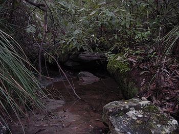
, New South Wales. Located in the Garigal National Park
Garigal National Park
Garigal National Park is a national park in New South Wales , 20 km north of central Sydney. The park is somewhat disjointed but covers the following areas:...
the creek flows from Mona Vale Road in the north down to Bungaroo
Bungaroo
Bungaroo is a rock bar that separates the salt water tidal Middle Harbour from fresh water Middle Harbour Creek located in Sydney, New South Wales. Located in the Garigal National Park it was first explored by Governor Arthur Phillip when his group used the spot as a camping site while searching...
where the creek becomes middle harbour. Access along the majority of the creek is easy with tracks from (the western shore) St Ives
St Ives, New South Wales
St Ives is a suburb on the Upper North Shore of Sydney in the state of New South Wales, Australia. St Ives is located 18 kilometres north of the Sydney Central Business District in the local government area of Ku-ring-gai Council...
, East Killara
East Killara, New South Wales
East Killara is a suburb on the Upper North Shore of Sydney in the state of New South Wales, Australia. East Killara is located 15 kilometres north-west of the Sydney Central Business District in the local government area of Ku-ring-gai Council. Killara is a separate suburb to the south-west.East...
, East Lindfield
East Lindfield, New South Wales
East Lindfield is a locality on the Upper North Shore of Sydney in the state of New South Wales, Australia. East Lindfield is located 13 kilometres north-west of the Sydney Central Business District in the local government area of Ku-ring-gai Council....
, (Eastern shore) Belrose
Belrose, New South Wales
Belrose is a suburb of the northern beaches, Sydney in the state of New South Wales, Australia, 19 kilometres north-east of the Sydney central business district in the local government area of Warringah Council, and is part of the Northern Beaches region...
, Davidson
Davidson, New South Wales
Davidson is a suburb of northern Sydney, in the state of New South Wales, Australia. Davidson is located 20 kilometres north-east of the Sydney central business district, in the local government area of Warringah Council...
, Frenchs Forest
Frenchs Forest, New South Wales
-Commercial areas:Forestway shopping centre is at the intersection of Forestway and Warringah Roads. During the 1960s and 1970s, this centre had the name Arndale...
and Forestville
Forestville, New South Wales
Forestville is a suburb of northern Sydney, in the state of New South Wales, Australia. Forestville is located 15 kilometres north-east of the Sydney central business district in the local government area of Warringah Council...
. Day walks are popular with access to the creek along several well maintained fire trails, the better-known being the Bungaroo Track
Bungaroo
Bungaroo is a rock bar that separates the salt water tidal Middle Harbour from fresh water Middle Harbour Creek located in Sydney, New South Wales. Located in the Garigal National Park it was first explored by Governor Arthur Phillip when his group used the spot as a camping site while searching...
, Cascades Track and Bare Creek track. The bushland surrounding the creek is rich in Bloodwoods (Eucalyptus gummifera, Scribbly gums (Eucalyptus haemastoma), The narrow-leaved stringy bark (Eucalyptus oblonga)
History
Middle Harbour creek was first explored by Governor Arthur PhillipArthur Phillip
Admiral Arthur Phillip RN was a British admiral and colonial administrator. Phillip was appointed Governor of New South Wales, the first European colony on the Australian continent, and was the founder of the settlement which is now the city of Sydney.-Early life and naval career:Arthur Phillip...
on an expedition that started from Manly Cove on 15 April 1788. Their original intention was to discover food. They camped on 16 April at Bungaroo where the tidal Middle Harbour finishes and the creek begins
Access
- Bungaroo TrackBungarooBungaroo is a rock bar that separates the salt water tidal Middle Harbour from fresh water Middle Harbour Creek located in Sydney, New South Wales. Located in the Garigal National Park it was first explored by Governor Arthur Phillip when his group used the spot as a camping site while searching...
- Cascades Track runs from the Corner of Acron Road and Douglas Street, St Ives or Stone Parade, Frenchs Forest. The track is a well maintained fire trail with an extremely steep cemented section and a creek crossing (from the St Ives side) at a ford before reaching the cascades, which is a beautiful cascading of water over sandstone. Until the 1970s the Cascades was a popular swimming water hole with local children. There are several sandstone caves in the area which offer walkers a great view of the area.
- Bare Creek Track runs from close to Austlink Corporate Park on the intersection of Mona Vale Road and Forest Way Roads, however the trail is overgrown and often difficult to find at that location. The best way to find the track is by following the trail from the end of Wyatt Avenue around the back of Sydney East Substation to find the Heath Track which meets the Bare Creek Track after a short walk.
External links
- The Northern Beaches Mountain Biking Group (NoBMoB) have details of trails around Cascades