

Mertz Glacier
Encyclopedia
Glacier
A glacier is a large persistent body of ice that forms where the accumulation of snow exceeds its ablation over many years, often centuries. At least 0.1 km² in area and 50 m thick, but often much larger, a glacier slowly deforms and flows due to stresses induced by its weight...
in George V Coast
George V Coast
George V Coast is that portion of the coast of Antarctica lying between Point Alden, at 142° 02' E, and Cape Hudson, at 153° 45' E. Explored by members of the Main Base party of the Australasian Antarctic Expedition under Douglas Mawson who named this feature for King George V of the United Kingdom...
of East Antarctica
East Antarctica
East Antarctica, also called Greater Antarctica, constitutes the majority of the Antarctic continent, lying on the Indian Ocean side of the Transantarctic Mountains...
. It is the source of a glacial prominence that historically has extended northward into the Southern Ocean
Southern Ocean
The Southern Ocean comprises the southernmost waters of the World Ocean, generally taken to be south of 60°S latitude and encircling Antarctica. It is usually regarded as the fourth-largest of the five principal oceanic divisions...
, the Mertz Glacial Tongue. It is named in honor of the Swiss explorer Xavier Mertz
Xavier Mertz
Xavier Mertz was a Swiss explorer, mountaineer and skier, from Basel. He took part in the Far Eastern Party, a 1912–13 component of the Australasian Antarctic Expedition, which claimed his life...
.
The Mertz-Ninnis Valley (67°25′S 146°0′E) is an undersea valley named in association with the Mertz Glacier and the Ninnis Glacier
Ninnis Glacier
Ninnis Glacier is a large, heavily hummocked and crevassed glacier descending steeply from the high interior to the sea in a broad valley, on George V Coast in Antarctica. It was discovered by the Australasian Antarctic Expedition under Douglas Mawson, who named it for Lieutenant B. E. S...
.
Geography
Mertz Glacier is about 45 miles (72 km) long and averaging 20 miles (32 km) wide. It reaches the sea at the head of a 60 km fjordFjord
Geologically, a fjord is a long, narrow inlet with steep sides or cliffs, created in a valley carved by glacial activity.-Formation:A fjord is formed when a glacier cuts a U-shaped valley by abrasion of the surrounding bedrock. Glacial melting is accompanied by rebound of Earth's crust as the ice...
where it continues as a large glacier tongue out between Cape De la Motte
Cape De la Motte
Cape De la Motte is a prominent cape separating Watt and Buchanan Bays. Just southward the continental ice surface rises 520 m at Mount Hunt. Charted by the Australasian Antarctic Expedition under Douglas Mawson, who named it for C.P...
/Buchanan Bay
Buchanan Bay
Buchanan Bay is an Arctic waterway in Qikiqtaaluk Region, Nunavut, Canada. It is located in Nares Strait by eastern Ellesmere Island. The bay is bordered by Cape Camperdown on Bache Peninsula to the north, Cape Rutherford on Johan Peninsula to the south, and the Alexandra Fiord at its head.It is ...
on the West, and Cape Hurley
Cape Hurley
Cape Hurley is an ice-covered coastal point marking on the east the mouth of the depression occupied by the Mertz Glacier. Discovered by the Australasian Antarctic Expedition under Douglas Mawson, who named it for Frank Hurley, official photographer of the expedition....
/Fisher Bay
Fisher Bay
Fisher Bay is an embayment about 14 miles wide between the eastern side of the Mertz Glacier Tongue and the mainland of Antarctica. It was discovered by the Australasian Antarctic Expedition under Douglas Mawson, who named it for Andrew Fisher, Prime Minister of Australia in 1911....
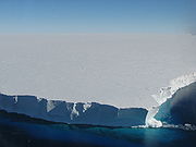
on the east, into the Southern Ocean. The Mertz Glacier Tongue (67°10′S 145°30′E) is about 50 miles (80 km) long in total hence it protrudes about 20–25 km out into the Ocean. It is roughly 25 miles (40 km) wide. The Glacier delivers about 10 to 12 Gigatons of ice per year to the fjord and the Tongue advances at about 1 km per year down the fjord and out into the Ocean.
History
The glacier was discovered by the Australasian Antarctic ExpeditionAustralasian Antarctic Expedition
The Australasian Antarctic Expedition was an Australasian scientific team that explored part of Antarctica between 1911 and 1914. It was led by the Australian geologist Douglas Mawson, who was knighted for his achievements in leading the expedition. In 1910 he began to plan an expedition to chart...
(1911–14) under Douglas Mawson
Douglas Mawson
Sir Douglas Mawson, OBE, FRS, FAA was an Australian geologist, Antarctic explorer and Academic. Along with Roald Amundsen, Robert Falcon Scott, and Ernest Shackleton, Mawson was a key expedition leader during the Heroic Age of Antarctic Exploration.-Early work:He was appointed geologist to an...
, who named it for Xavier Mertz, a member of the expedition who lost his life on January 7, 1913. Mertz's body likely remains in the glacier that bears his name, a few miles closer to the Southern Ocean than when he was buried in the ice by Mawson.
2010 calving
In February 2010 about half of the Mertz Glacier Tongue, a piece of ice about 78 kilometres (48.5 mi) long and 33–39 km (20.5–24.2 mi) wide and protruding 100 kilometres (62.1 mi) out into the Southern OceanSouthern Ocean
The Southern Ocean comprises the southernmost waters of the World Ocean, generally taken to be south of 60°S latitude and encircling Antarctica. It is usually regarded as the fourth-largest of the five principal oceanic divisions...
, broke away from the main body of the Tongue. The separation occurred around the 12 or 13 February along two existing rift lines on opposite sides of the Tongue. The event was helped in part when the large Iceberg B-9B collided with it. Iceberg B-9B is a 97 kilometres (60.3 mi) long by 30 kilometres (18.6 mi) wide remnant of Iceberg B-9
Iceberg B-9
Iceberg B-9 154 km by 35 km calved away from Antarctica, from the sector east of Roosevelt Island, neighbouring the Bay of Whales and immediately east of the calving site of Iceberg B-15. It carried away Little America V....
which broke off the Ross Ice Shelf
Ross Ice Shelf
The Ross Ice Shelf is the largest ice shelf of Antarctica . It is several hundred metres thick. The nearly vertical ice front to the open sea is more than 600 km long, and between 15 and 50 metres high above the water surface...
in 1987 and has recently ungrounded itself from Ninnis Bank to the east of the Tongue where it had been lodged for 18 years.
The newly formed iceberg has been named Iceberg C-28, because it is the 28th substantial iceberg to have broken off the Antarctic ice shelf, in the quadrant that faces Australia, since 1976. The iceberg is 400 metres (1,312.3 ft) high, has a surface area of 2545 square kilometres (982.6 sq mi) and wei ghs in at about 860 billion tonnes. According to Australian glaciologist Neal Young, such an event occurs once in 50 to 100 years. As the Tongue advances at 1 km per year this new iceberg represents about 70 years of glacier advance.
Within 2 weeks the Mertz Iceberg rotated about the point of impact with B9-B and lay parallel with the coastline.
The iceberg drifted westwards after the collision and in April 2010 hit a submerged peak which caused it to break into two pieces.
The flow of icebergs from the calved glacier tongue has reduced the effectiveness of the polynya
Polynya
A polynya or polynia is an area of open water surrounded by sea ice. It is now used as geographical term for an area of unfrozen sea within the ice pack. It is a loanword from , , which means a natural ice hole, and was adopted in the 19th century by polar explorers to describe navigable...
west of Mertz Glacier that acted as one of Antarctica's major dense salty water formation zones. The calving could affect future circulation of the Thermohaline around Antarctica.
See also
- Ice streamIce streamAn ice stream is a region of an ice sheet that moves significantly faster than the surrounding ice. Ice streams are a type of glacier. They are significant features of the Antarctic where they account for 10% of the volume of the ice...
- List of glaciers in the Antarctic
- List of Antarctic ice streams
- Petermann GlacierPetermann glacierPetermann Glacier is a large glacier located in North-West Greenland to the east of Nares Strait. It connects the Greenland ice sheet to the Arctic Ocean near 81 degrees north latitude. The tidewater glacier consists of a long and wide floating ice tongue whose thickness changes from about at...
- Wilkins SoundWilkins SoundWilkins Sound is a seaway in Antarctica that is largely occupied by the Wilkins Ice Shelf. It is located on the southwest side of the Antarctic Peninsula between the concave western coastline of Alexander Island and the shores of Charcot Island and Latady Island farther to the west.Its northern...