
.gif)
Meon Valley Railway Line (trail)
Encyclopedia
Hampshire
Hampshire is a county on the southern coast of England in the United Kingdom. The county town of Hampshire is Winchester, a historic cathedral city that was once the capital of England. Hampshire is notable for housing the original birthplaces of the Royal Navy, British Army, and Royal Air Force...
, England
England
England is a country that is part of the United Kingdom. It shares land borders with Scotland to the north and Wales to the west; the Irish Sea is to the north west, the Celtic Sea to the south west, with the North Sea to the east and the English Channel to the south separating it from continental...
.
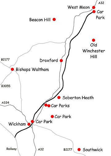
The trail follows part of the bed of the former Meon Valley Railway
Meon Valley Railway
The Meon Valley Railway was a cross-country railway in Hampshire, England that ran for between Alton and Fareham, closely following the course of the River Meon. At its northern end, it joined with the Mid-Hants Railway to Winchester, the Alton Line to Brookwood and the Basingstoke and Alton...
(Alton
Alton, Hampshire
Alton is a historic market town and civil parish in the East Hampshire district of the English county of Hampshire. It had a population of 16,584 at the 1991 census and is administered by East Hampshire district council. It is located on the source of the River Wey and is the highest town in...
to Fareham
Fareham
The market town of Fareham lies in the south east of Hampshire, England, between the cities of Southampton and Portsmouth, roughly in the centre of the South Hampshire conurbation.It gives its name to the borough comprising the town and the surrounding area...
), which closed in 1968. It ends at West Meon
West Meon
West Meon is a small village in Hampshire, England, with a population of 690.It is situated near to Petersfield and East Meon, on the headwaters of the River Meon....
due to removal of the former viaduct across the Meon Valley, and the presence of tunnels further north.
The section from West Meon
West Meon
West Meon is a small village in Hampshire, England, with a population of 690.It is situated near to Petersfield and East Meon, on the headwaters of the River Meon....
south to the Eastleigh
Eastleigh
Eastleigh is a railway town in Hampshire, England, and the main town in the Eastleigh borough which is part of Southampton Urban Area. The town lies between Southampton and Winchester, and is part of the South Hampshire conurbation...
to Fareham
Fareham
The market town of Fareham lies in the south east of Hampshire, England, between the cities of Southampton and Portsmouth, roughly in the centre of the South Hampshire conurbation.It gives its name to the borough comprising the town and the surrounding area...
line is open to walkers, cyclists and horse riders and uses existing public bridleways and some newly created permissive bridleways.
The route from West Meon to Wickham
Wickham
Wickham, formerly spelled Wykeham, is a small historic village and civil parish in Hampshire, southern England, located about three miles north of Fareham. It is within the City of Winchester local government district, although it is considerably closer to Fareham than to Winchester...
to is 14.5 km (9 mi); the further 3 kilometre section south-west of Wickham is a dead end.
There are free car parks at West Meon (off Station Road) and at Wickham (also off Station Road). There are also pay car parks in West Walk (part of the Forest of Bere
Forest of Bere
The Forest of Bere lies north of Fareham. A mixture of woodland, open space, ponds, streams, heathland, farmland and downland it provides countryside access to the residents of South-East Hampshire having a number of paths and bridleways for walking and cycling...
).
The route is level but can be muddy in places. The northern section emerges from the cutting south of West Meon onto an embankment which gives views of Old Winchester Hill
Old Winchester Hill
Old Winchester Hill is a chalk hill in Hampshire, England surmounted by an Iron Age hill fort and a Bronze Age cemetery. It is a Site of Special Scientific Interest and a National Nature Reserve. The hill fort has never been fully excavated.-Location:...
to the east and Beacon Hill
Beacon Hill, Warnford, Hampshire
Beacon Hill, Warnford, Hampshire is a chalk hill in the South Downs on the boundary of the parishes of Warnford and Exton. Part of the hill is a National Nature Reserve and biological SSSI, first notified in 1979.The hill-Location:...
to the west. A few former bridges on the route have been dismantled, necessitating descent to cross minor roads. There is access at several points along the route including Meonstoke
Meonstoke
Meonstoke is a village in Hampshire, England. Meonstoke lies in the Meon Valley where it cuts through the Middle Chalk of the South Downs. Old Winchester Hill is at the edge of the parish to the east....
which has a pub and shop. The current temporary South Downs Way
South Downs Way
The South Downs Way is a long distance footpath and bridleway running along the South Downs in southern England, and is one of 15 National Trails in England and Wales...
route crosses the trail to the east of Exton
Exton, Hampshire
Exton is a small village and civil parish in the City of Winchester district of Hampshire, England. The village lies in the South Downs National Park, on the west bank of the River Meon, immediately to the north of Corhampton. It is located two miles north east of Droxford and five miles north...
with an access point. Ironically the bridge by which the Monarch's Way
Monarch's Way
The Monarch's Way is a long-distance footpath in England that approximates the escape route taken by King Charles II in 1651 after being defeated in the Battle of Worcester.Most of the footpath is waymarked...
crosses the trail east of Warnford
Warnford
Warnford is a village and civil parish in the City of Winchester district of Hampshire, England.The village lies on the A32 in the valley of the River Meon between West Meon and Exton. It has a church and a pub, . There is an infrequent bus service from Bishop's Waltham to Petersfield...
is intact with no access, but the trail can be joined by a short diversion along the South Downs Way.
Various circular routes are possible, for example using the trail from West Meon to Meonstoke, taking the South Downs Way
South Downs Way
The South Downs Way is a long distance footpath and bridleway running along the South Downs in southern England, and is one of 15 National Trails in England and Wales...
via Corhampton and Beacon Hill, and Monarch's way to Warnford, returning by local footpaths.
The A32
A32 road
The A32 is a road in Hampshire, southern England, that links Gosport and Alton. Starting at Gosport, facing Portsmouth, it travels north via Fareham, Wickham, Droxford, before joining the A31 road near Alton...
main road follows a similar route to the trail.