

Memphis Parkway System
Encyclopedia
The Memphis Parkway System, locally known as the Parkway System, The Parkways, or simply by their individual names is a system of parkway
s that formed the original outer beltway around Memphis, Tennessee
. They consist of South Parkway, East Parkway, and North Parkway. Designed by George Kessler
, the Parkway System connects Martin Luther King Jr. Riverside Park with Overton Park
. The system was put on the National Register of Historic Places on July 3, 1989.
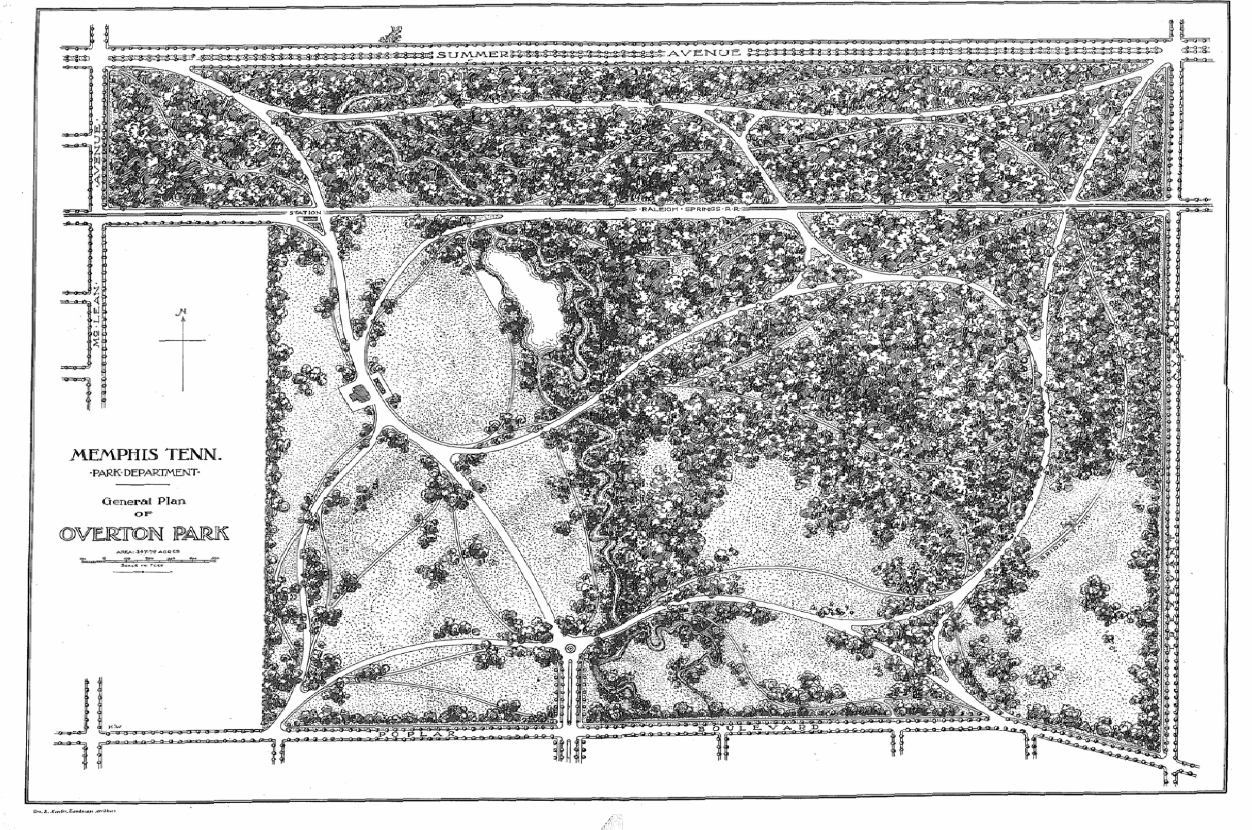 In response to the yellow fever epidemic and in an attempt to revitalize Memphis, the city's leaders decided to improve the city's infrastructure, including improving sewer systems, creating public utilities, and creating a system of parks connected by a system of boulevards. Starting in 1897, several areas of land were annexed into the city, along with the areas that now comprise the parks mentioned above. These lands were purchased in 1901. In that same year, the city selected George Kessler to lay out this new plan. Planning and construction of the Lea's Woods tract of land (now known as Overton Park) was started in 1902 and completed in the same year. The development and construction of Wilderberger Farm (now known as Martin Luther King Jr. Riverside Park) started in the same year, but finished a year later in 1903.
The development and construction of what is now known as the Parkway System started in 1904. The project had been delayed due to a lawsuit stating the government was using its power of eminent domain
incorrectly, but the Tennessee Supreme Court found in favor of the city. Instead of a winding system of meandering parkways, Kessler decided to create a rectangular border around the city of Memphis using some existing streets. South Parkway and East Parkway (originally Trezevant Street) were constructed first. North Parkway was originally known as Summer Avenue (the name still carried by the route as it continues east from the intersection of North and East Parkways). North Parkway was also known as Speedway. Kessler originally designed parts of the Parkway System to be straight portions of tree-lined avenues where car and carriage owners could race against each other. However, the city of Memphis ended this practice in 1910 and imposed a speed limit on the entire system. Today, the road's racing past can still be seen in the name of the Speedway Terrace Historical District along North Parkway near Watkins Street.
The entire parkway system was completed in 1906. After its completion, residential development along its route increased. Many cities in Tennessee used Memphis' park and parkway system as a model for their own urban planning. The Parkway System roughly marked the city's boundaries for many years to come and is still an important corridor in the city of Memphis.
next to the park and continues east. This portion, known as South Parkway West, is a four-lane undivided road through an industrial area with no boulevard median or landscaping. After crossing Interstate 240
, the section known as South Parkway East becomes divided with a wooded boulevard median, like the majority of the parkways.
South Parkway, after passing U.S. Highway 78 (Lamar Avenue), turns into East Parkway South at its intersection with Airways Boulevard and Spottswood Avenue. It also picks up the designation of Tennessee State Route 277. East Parkway South continues north until it crosses under Union Avenue and becomes East Parkway North. At this point, it picks up U.S. Highway 70, U.S. Highway 79, U.S. Highway 72, and U.S. Highway 64 in addition to keeping the SR 277 designation. When it passes Poplar Avenue, Hwy 72 goes to the east, but it picks up the Tennessee State Route 57
designation. At this point, it passes to the east of Overton Park and intersects with Sam Cooper Boulevard
.
When East Parkway meets North Parkway, it loses all of the above-mentioned U.S. highways to the east (Summer Avenue) and the state highways to the north (Trezevant Street). However North Parkway picks up the Tennessee State Route 1 designation and is one of the only sections in the state to have this route signed. North Parkway continues west, crosses Interstate 40
, and ends at U.S. Highway 51/Tennessee State Route 3/Tennessee State Route 14
(Danny Thomas Boulevard). The road continues west as A.W. Willis Avenue, crossing the Wolf River Harbor
, and ending on Mud Island
.
Except for the South Parkway West section, the entire system is divided by a large median containing several trees, most of them very large and mature, and sections of flowered landscaping. South Parkway has two lanes in each direction, while North and East Parkways have three lanes in each direction (except for when the routes pass under other roadways, in which case each direction narrows to two lanes, and the four northbound lanes of East Parkway between Poplar and Sam Cooper). The entire system has a forty-mile-per-hour speed limit.
South Parkway Section
East Parkway Section
North Parkway Section
Parkway
The term parkway has several distinct principal meanings and numerous synonyms around the world, for either a type of landscaped area or a type of road.Type of landscaped area:...
s that formed the original outer beltway around Memphis, Tennessee
Memphis, Tennessee
Memphis is a city in the southwestern corner of the U.S. state of Tennessee, and the county seat of Shelby County. The city is located on the 4th Chickasaw Bluff, south of the confluence of the Wolf and Mississippi rivers....
. They consist of South Parkway, East Parkway, and North Parkway. Designed by George Kessler
George Kessler
George Edward Kessler was a German American pioneer city planner and landscape architect.Over the course of his forty-one year career, George E. Kessler completed over 200 projects and prepared plans for 26 communities, 26 park and boulevard systems, 49 parks, 46 estates & residents, and 26 schools...
, the Parkway System connects Martin Luther King Jr. Riverside Park with Overton Park
Overton Park
Overton Park is a large, public park in Midtown Memphis, Tennessee. The park grounds contain the Memphis Brooks Museum of Art, Memphis Zoo, a 9-hole golf course, Memphis College of Art, Rainbow Lake, Veterans Plaza, Greensward, and other features...
. The system was put on the National Register of Historic Places on July 3, 1989.
History
The development and construction of what is now known as the Parkway System started in 1904. The project had been delayed due to a lawsuit stating the government was using its power of eminent domain
Eminent domain
Eminent domain , compulsory purchase , resumption/compulsory acquisition , or expropriation is an action of the state to seize a citizen's private property, expropriate property, or seize a citizen's rights in property with due monetary compensation, but without the owner's consent...
incorrectly, but the Tennessee Supreme Court found in favor of the city. Instead of a winding system of meandering parkways, Kessler decided to create a rectangular border around the city of Memphis using some existing streets. South Parkway and East Parkway (originally Trezevant Street) were constructed first. North Parkway was originally known as Summer Avenue (the name still carried by the route as it continues east from the intersection of North and East Parkways). North Parkway was also known as Speedway. Kessler originally designed parts of the Parkway System to be straight portions of tree-lined avenues where car and carriage owners could race against each other. However, the city of Memphis ended this practice in 1910 and imposed a speed limit on the entire system. Today, the road's racing past can still be seen in the name of the Speedway Terrace Historical District along North Parkway near Watkins Street.
The entire parkway system was completed in 1906. After its completion, residential development along its route increased. Many cities in Tennessee used Memphis' park and parkway system as a model for their own urban planning. The Parkway System roughly marked the city's boundaries for many years to come and is still an important corridor in the city of Memphis.
Route Description
Moving in a counter-clockwise direction from the southwest corner, the Parkway System starts at Martin Luther King Jr. Riverside Park. It crosses Interstate 55Interstate 55
Interstate 55 is an Interstate Highway in the central United States. Its odd number indicates that it is a north–south Interstate Highway. I-55 goes from LaPlace, Louisiana at Interstate 10 to Chicago at U.S. Route 41 , at McCormick Place. A common nickname for the highway is "double...
next to the park and continues east. This portion, known as South Parkway West, is a four-lane undivided road through an industrial area with no boulevard median or landscaping. After crossing Interstate 240
Interstate 240
Interstate 240 may refer to:* Interstate 240 , a connection into Asheville, North Carolina* Interstate 240 , a freeway on the south side of Oklahoma City* Interstate 240 , a bypass of Memphis, Tennessee...
, the section known as South Parkway East becomes divided with a wooded boulevard median, like the majority of the parkways.
South Parkway, after passing U.S. Highway 78 (Lamar Avenue), turns into East Parkway South at its intersection with Airways Boulevard and Spottswood Avenue. It also picks up the designation of Tennessee State Route 277. East Parkway South continues north until it crosses under Union Avenue and becomes East Parkway North. At this point, it picks up U.S. Highway 70, U.S. Highway 79, U.S. Highway 72, and U.S. Highway 64 in addition to keeping the SR 277 designation. When it passes Poplar Avenue, Hwy 72 goes to the east, but it picks up the Tennessee State Route 57
Tennessee State Route 57
Tennessee State Route 57 is an east–west highway that runs from Memphis to the Mississippi state line near Pickwick Dam and Pickwick Landing State Park. Except for in Shelby County, SR 57 is a two lane road generally with a speed limit...
designation. At this point, it passes to the east of Overton Park and intersects with Sam Cooper Boulevard
Sam Cooper Boulevard
Sam Cooper Boulevard is a six-lane controlled-access parkway/expressway in Memphis, Tennessee, U.S.A.. The more recent western segment of the road follows a parkway design, the older eastern portion which was proposed and constructed as a segment of Interstate 40 is built as an expressway, without...
.
When East Parkway meets North Parkway, it loses all of the above-mentioned U.S. highways to the east (Summer Avenue) and the state highways to the north (Trezevant Street). However North Parkway picks up the Tennessee State Route 1 designation and is one of the only sections in the state to have this route signed. North Parkway continues west, crosses Interstate 40
Interstate 40
Interstate 40 is the third-longest major east–west Interstate Highway in the United States, after I-90 and I-80. Its western end is at Interstate 15 in Barstow, California; its eastern end is at a concurrency of U.S. Route 117 and North Carolina Highway 132 in Wilmington, North Carolina...
, and ends at U.S. Highway 51/Tennessee State Route 3/Tennessee State Route 14
Tennessee State Route 14
State Route 14 is a south–north route from the Mississippi border in Memphis, Tennessee to intersect with State Route 54 in Tipton County.- Route description :...
(Danny Thomas Boulevard). The road continues west as A.W. Willis Avenue, crossing the Wolf River Harbor
Wolf River (Tennessee)
The Wolf River is a alluvial stream in western Tennessee and northern Mississippi, whose confluence with the Mississippi River was the site of various Chickasaw, French, Spanish and American communities and forts that eventually became Memphis, Tennessee....
, and ending on Mud Island
Mud Island, Memphis
Mud Island is not actually an island but a small peninsula, surrounded by the Mississippi River to the west and the Wolf River Harbor to the east. In 1960, the Wolf River was diverted so that it went north of Mud Island, and Mud Island opened to the public in 1982...
.
Except for the South Parkway West section, the entire system is divided by a large median containing several trees, most of them very large and mature, and sections of flowered landscaping. South Parkway has two lanes in each direction, while North and East Parkways have three lanes in each direction (except for when the routes pass under other roadways, in which case each direction narrows to two lanes, and the four northbound lanes of East Parkway between Poplar and Sam Cooper). The entire system has a forty-mile-per-hour speed limit.
Landmarks
Below is a list of landmarks within close proximity of the parkways.South Parkway Section
- President's IslandPresident's IslandPresident's Island is a peninsula on the Mississippi River in southwest Memphis, Tennessee. The city's major river port and an industrial park are located there.-History:...
/ McKellar Lake - M.L.K. Riverside Park
East Parkway Section
- Cooper-Young, MemphisCooper-Young, MemphisCooper-Young is an eclectic neighborhood and historic district in the Midtown section of Memphis, Tennessee, named for the intersection of Cooper Street and Young Avenue. The entrance to the neighborhood is marked by the Cooper-Young Trestle, a long steel sculpture which depicts homes and...
- Christian Brothers UniversityChristian Brothers UniversityChristian Brothers University is the oldest collegiate degree-granting institution in the city of Memphis. The university is run by the Christian Brothers, a Roman Catholic religious order founded by St. John Baptist de la Salle, the patron saint of teachers...
- Children's Museum of MemphisChildren's Museum of MemphisThe Children's Museum of Memphis is located in Midtown Memphis at 2525 Central Avenue in Memphis, Tennessee, USA.CMOM’s mission is to create memorable learning experiences through the joy of play in hands-on exhibits and programs. The museum offers interactive and educational exhibits and...
- Mid-South ColiseumMid-South ColiseumThe Mid-South Coliseum, also known as "The Entertainment Capital of the Mid-South", was a multi-purpose arena, that seated 10,085 people, in Memphis, Tennessee...
- Liberty Bowl Memorial StadiumLiberty Bowl Memorial StadiumLiberty Bowl Memorial Stadium is a football stadium, located at the Mid-South Fairgrounds, in Midtown Memphis, Tennessee, United States. The stadium is the site of the annual AutoZone Liberty Bowl, and is the home field of the University of Memphis Tigers football team...
- Memphis Theological SeminaryMemphis Theological SeminaryMemphis Theological Seminary is an ecumenical theological seminary located in Midtown, Memphis, Tennessee. It is affiliated with the Cumberland Presbyterian Church, but accepts and trains ministerial candidates from other groups as well...
- Memphis Brooks Museum of ArtMemphis Brooks Museum of ArtMemphis Brooks Museum of Art is an art museum in Memphis, Tennessee. The Brooks Museum, which was founded in 1916, is the oldest and largest art museum in the state of Tennessee. The museum is a privately funded nonprofit institution located in Overton Park in Midtown Memphis.The original...
- Overton ParkOverton ParkOverton Park is a large, public park in Midtown Memphis, Tennessee. The park grounds contain the Memphis Brooks Museum of Art, Memphis Zoo, a 9-hole golf course, Memphis College of Art, Rainbow Lake, Veterans Plaza, Greensward, and other features...
North Parkway Section
- Memphis ZooMemphis ZooThe Memphis Zoo, located in Midtown Memphis, Tennessee, is home to more than 3,500 animals representing over 500 different species. Created in April 1906, the zoo has been a major tenant of Overton Park for more than 100 years. The land currently designated to the Memphis Zoo was defined by the...
- Rhodes CollegeRhodes CollegeRhodes College is a private, predominantly undergraduate, liberal arts college located in Memphis, Tennessee, USA. Originally founded by freemasons in 1848, Rhodes became affiliated with the Presbyterian Church in 1855. Rhodes enrolls approximately 1,700 students pursuing bachelor's and master's...
- St. Jude Children's Research HospitalSt. Jude Children's Research HospitalSt. Jude Children's Research Hospital, founded in 1962, is a leading pediatric treatment and research facility focused on children's catastrophic diseases. It is located in Memphis, Tennessee. It is a nonprofit medical corporation chartered as a 501 tax-exempt organization under IRS regulations.In...
- Pyramid ArenaPyramid ArenaThe Pyramid Arena is a 20,142-seat arena located in downtown Memphis at the banks of the Mississippi River. The facility was built in 1991 and was originally owned and operated jointly by the city of Memphis and Shelby County. Its unique structure plays on the city's namesake in Egypt, known for...