

McGarry, Ontario
Encyclopedia
McGarry is a township
in the Canadian province of Ontario
, located within the Timiskaming District
.
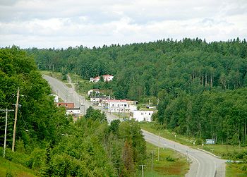
The township includes the communities of Virginiatown and Kearns. It is situated on the border with Quebec, along Highway 66
between Kirkland Lake and Rouyn-Noranda.
Private dwellings, excluding seasonal cottages: 325 (total: 429)
Mother tongue:
Township (Canada)
The term township generally means the district or area associated with a town. However in some systems no town needs to be involved. The specific use of the term to describe political subdivisions has varied by country, usually to describe a local rural or semi-rural government within the county...
in the Canadian province of Ontario
Ontario
Ontario is a province of Canada, located in east-central Canada. It is Canada's most populous province and second largest in total area. It is home to the nation's most populous city, Toronto, and the nation's capital, Ottawa....
, located within the Timiskaming District
Timiskaming District, Ontario
Timiskaming is a district and census division in Northeastern Ontario in the Canadian province of Ontario. The district was created in 1912 from parts of Algoma, Nipissing, and Sudbury districts. In 1921, Cochrane District was created from parts of this district and parts of Thunder Bay...
.
The township includes the communities of Virginiatown and Kearns. It is situated on the border with Quebec, along Highway 66
Highway 66 (Ontario)
King's Highway 66, commonly referred to as Highway 66, is a provincially maintained highway in the Canadian province of Ontario.Located in the Timiskaming District, the highway begins at Matachewan near a junction with Highway 65. It extends eastward for to the Quebec border just east of...
between Kirkland Lake and Rouyn-Noranda.
Demographics
Population:- Population in 2006: 674 (2001 to 2006 population change: -14.4 %)
- Population in 2001: 787
- Population in 1996: 1015
- Population in 1991: 1139
Private dwellings, excluding seasonal cottages: 325 (total: 429)
Mother tongue:
- English as first language: 30.5 %
- French as first language: 63 %
- English and French as first language: 1.5 %
- Other as first language: 5 %
External links
- Community profile (2008)
- Township of McGarry
- Image of McGarry Township Building, circa 1953 from RootsWeb