

Mayfair, Philadelphia, Pennsylvania
Encyclopedia
Northeast Philadelphia
Northeast Philadelphia, nicknamed Northeast Philly, the Northeast and the Great Northeast, is a section of the city of Philadelphia, Pennsylvania. According to the 2000 Census, the Northeast has a sizable percentage of the city's 1.547 million people — a population of between 300,000 and 450,000,...
section of Philadelphia, Pennsylvania
Philadelphia, Pennsylvania
Philadelphia is the largest city in the Commonwealth of Pennsylvania and the county seat of Philadelphia County, with which it is coterminous. The city is located in the Northeastern United States along the Delaware and Schuylkill rivers. It is the fifth-most-populous city in the United States,...
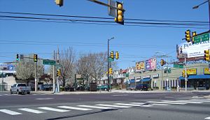
centered on the intersection of Cottman and Frankford Avenues. It is bordered by Tacony
Tacony, Philadelphia, Pennsylvania
Tacony is a historic neighborhood in Northeast Philadelphia, about from downtown Philadelphia. It is the oldest continuously occupied neighborhood in Philadelphia. It is bounded by Frankford Avenue on the northwest, Cottman Avenue on the northeast, Levick Street on the southwest, and the...
to the south and east, Holmesburg
Holmesburg, Philadelphia, Pennsylvania
Holmesburg is a neighborhood in the Northeast section of Philadelphia, Pennsylvania. Holmesburg was named for the descendants of John Holme who immigrated to Philadelphia in the 1680s and had no known relation to Surveyor General Thomas Holme. John Holme's descendants acquired land in Lower...
to the east, Pennypack Park
Pennypack Park
Pennypack Park is a municipal park, part of Philadelphia's Fairmount Park system, in Northeast Philadelphia in the U.S. state of Pennsylvania. Established in 1905 by ordinance of the City of Philadelphia, it includes about of woodlands, meadows and wetlands. The Pennypack Creek runs through the...
to the north, and Oxford Circle
Oxford Circle, Philadelphia, Pennsylvania
Oxford Circle is a neighborhood in the lower Northeast section of Philadelphia, Pennsylvania, United States. Its namesake is the much used traffic circle...
and Rhawnhurst
Rhawnhurst, Philadelphia, Pennsylvania
Rhawnhurst is a residential neighborhood in the Northeast section of Philadelphia, named for George and William Rhawn by area real estate developers. Roughly bordered by Cottman Avenue to the south, Pennway Street to the west, the Pennypack Creek to the north, and Roosevelt Boulevard to the east,...
to the west.
History
Before development in the 1920's, Mayfair was essentially farmland and home to The Edwin Forrest Home for Children (near present day Frankford and Shelmire Avenue) and The Oxford and Lower Dublin Poor House (west of present day Rowland and Sheffield Aves). First established in 1929, Mayfair came to fruition in the years following World War IIWorld War II
World War II, or the Second World War , was a global conflict lasting from 1939 to 1945, involving most of the world's nations—including all of the great powers—eventually forming two opposing military alliances: the Allies and the Axis...
as a community that provided fresher and more spacious living in an urban environment. It was constructed over farmland surrounded by the established neighborhoods of Tacony, Holmesburg and Fox Chase. Mayfair featured several groundbreaking concepts for city dwellers: bigger rowhomes
Terraced house
In architecture and city planning, a terrace house, terrace, row house, linked house or townhouse is a style of medium-density housing that originated in Great Britain in the late 17th century, where a row of identical or mirror-image houses share side walls...
with yards in the front and parking garages in the back. The automobile
Automobile
An automobile, autocar, motor car or car is a wheeled motor vehicle used for transporting passengers, which also carries its own engine or motor...
became the primary mode of transportation and shopping retail centers became available close to home, as shopping districts developed along Roosevelt Boulevard
Roosevelt Boulevard
The following roads are called Roosevelt Boulevard:*Roosevelt Boulevard in Jacksonville, Florida*Roosevelt Boulevard between Marmora and Ocean City, New Jersey*Roosevelt Boulevard in Philadelphia, Pennsylvania...
and Cottman Avenue. Development also served to connect the surrounding neighborhoods of the Northeast that had previously been isolated. In these regards, Mayfair was a forerunner to American suburbanization
Suburbanization
Suburbanization a term used to describe the growth of areas on the fringes of major cities. It is one of the many causes of the increase in urban sprawl. Many residents of metropolitan regions work within the central urban area, choosing instead to live in satellite communities called suburbs...
, an early part of the population shift from the inner city to its outer regions.
Population
As of the 2000 census, the tracts covering most of Mayfair had a population of 33,514 people, 95% white and mostly in owner-occupied rowhomes. About 90 percent of the population was born in Pennsylvania.Mayfair is widely known for its association with Irish-American culture and has long been a bastion of the Philadelphia Irish. During the 2000 census, 14,682 people noted Irish ancestry, including 11,100 who claimed it as their primary ancestry. Other claimed ancestries of note were German (7,069), Italian (6,067), Polish (3,512), and English (2,442). Like most of the city's Northeast, the demographics of the area have experienced an increase in diversification since 2000, with the integration of Asians, Arabs, Blacks and Hispanics in the communities.
Mayfair uses the ZIP codes 19135, 19136, 19149 and 19152.