
Maxwell Lake
Encyclopedia
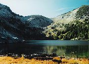
Maxwell Lake is a tarn
located in the Eagle Cap Wilderness
of Northeastern Oregon
. It is situated near the North Minam Meadows and is 16 aerial miles from the town of Lostine, Oregon
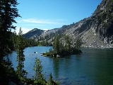
. It is known for its two small islands and typically successful fishing, which make it a popular day hiking and overnight backpacking destination. It is the 16th highest lake in the Eagle Cap Wilderness
.
that has an exclusive trail. The trail, which is named after the lake, has the trail number 1674. It is 4 miles long (one way) and the U.S. Forest Service
lists it as "More difficult". Less than half a mile from the beginning the trail crosses a small bridge. The trail then begins to switchback
for several miles, crossing Maxwell Creek. Here the trail has no bridge and the climber is forced to find another means to cross. Though somewhat shallow in the summer and fall, Maxwell Creek can be fairly deep in the spring time. The trail straightens for the last mile, but gains elevation quickly. This part of the trail may be difficult for some climbers.
Tarn (lake)
A tarn is a mountain lake or pool, formed in a cirque excavated by a glacier. A moraine may form a natural dam below a tarn. A corrie may be called a cirque.The word is derived from the Old Norse word tjörn meaning pond...
located in the Eagle Cap Wilderness
Eagle Cap Wilderness
Eagle Cap Wilderness is a wilderness area located in the Wallowa Mountains of northeastern Oregon , within the Wallowa–Whitman National Forest. The Wilderness was established in 1940. In 1964, it was included in the National Wilderness Preservation System...
of Northeastern Oregon
Oregon
Oregon is a state in the Pacific Northwest region of the United States. It is located on the Pacific coast, with Washington to the north, California to the south, Nevada on the southeast and Idaho to the east. The Columbia and Snake rivers delineate much of Oregon's northern and eastern...
. It is situated near the North Minam Meadows and is 16 aerial miles from the town of Lostine, Oregon
Lostine, Oregon
Lostine is a city in Wallowa County, Oregon, United States. The population was 263 at the 2000 census.-Geography:According to the United States Census Bureau, the city has a total area of , all land.-Demographics:...
. It is known for its two small islands and typically successful fishing, which make it a popular day hiking and overnight backpacking destination. It is the 16th highest lake in the Eagle Cap Wilderness
Eagle Cap Wilderness
Eagle Cap Wilderness is a wilderness area located in the Wallowa Mountains of northeastern Oregon , within the Wallowa–Whitman National Forest. The Wilderness was established in 1940. In 1964, it was included in the National Wilderness Preservation System...
.
Trail
Maxwell Lake is one of the few lakes in the Eagle Cap WildernessEagle Cap Wilderness
Eagle Cap Wilderness is a wilderness area located in the Wallowa Mountains of northeastern Oregon , within the Wallowa–Whitman National Forest. The Wilderness was established in 1940. In 1964, it was included in the National Wilderness Preservation System...
that has an exclusive trail. The trail, which is named after the lake, has the trail number 1674. It is 4 miles long (one way) and the U.S. Forest Service
United States Forest Service
The United States Forest Service is an agency of the United States Department of Agriculture that administers the nation's 155 national forests and 20 national grasslands, which encompass...
lists it as "More difficult". Less than half a mile from the beginning the trail crosses a small bridge. The trail then begins to switchback
Hairpin turn
A hairpin turn , named for its resemblance to a hairpin/bobby pin, is a bend in a road with a very acute inner angle, making it necessary for an oncoming vehicle to turn almost 180° to continue on the road. Such turns in ramps and trails may be called switchbacks in American English, by analogy...
for several miles, crossing Maxwell Creek. Here the trail has no bridge and the climber is forced to find another means to cross. Though somewhat shallow in the summer and fall, Maxwell Creek can be fairly deep in the spring time. The trail straightens for the last mile, but gains elevation quickly. This part of the trail may be difficult for some climbers.