

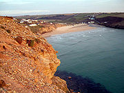
Mawgan Porth
Encyclopedia
Cornwall
Cornwall is a unitary authority and ceremonial county of England, within the United Kingdom. It is bordered to the north and west by the Celtic Sea, to the south by the English Channel, and to the east by the county of Devon, over the River Tamar. Cornwall has a population of , and covers an area of...
, England, United Kingdom. It is situated north of Watergate Bay
Watergate Bay
Watergate Bay is a bay located two miles north of Newquay on the B3276 Newquay to Padstow road near the village of Tregurrian in Cornwall, United Kingdom. It faces the Atlantic Ocean....
approximately four miles (6 km) north of Newquay
Newquay
Newquay is a town, civil parish, seaside resort and fishing port in Cornwall, England. It is situated on the North Atlantic coast of Cornwall approximately west of Bodmin and north of Truro....
, on the Atlantic Ocean
Atlantic Ocean
The Atlantic Ocean is the second-largest of the world's oceanic divisions. With a total area of about , it covers approximately 20% of the Earth's surface and about 26% of its water surface area...
coast.
Mawgan Porth is in the civil parish
Civil parish
In England, a civil parish is a territorial designation and, where they are found, the lowest tier of local government below districts and counties...
of Mawgan-in-Pydar
St Mawgan
St Mawgan in Pydar is a civil parish in Cornwall, United Kingdom. The village of St Mawgan is situated four miles northeast of Newquay....
at the seaward end of the Vale of Lanherne (or Vale of Mawgan) where the River Menalhyl
River Menalhyl
The River Menalhyl is a river in Cornwall, UK, that flows through the parishes of St Columb Major and Mawgan-in-Pydar. Its length is about 12 miles and it flows in a generally north-west direction...
discharges into the sea. The hamlet consists of a pub, a general store, and several hotels, guest houses and caravan parks.
The sandy beach, backed by dunes with cliffs at each end, is quality-assessed and supervised by lifeguards during the summer. It is a popular surfing
Surfing
Surfing' is a surface water sport in which the surfer rides a surfboard on the crest and face of a wave which is carrying the surfer towards the shore...
location. The South West Coast Path
South West Coast Path
The South West Coast Path is Britain's longest waymarked long-distance footpath and a National Trail. It stretches for , running from Minehead in Somerset, along the coasts of Devon and Cornwall, to Poole Harbour in Dorset. Since it rises and falls with every river mouth, it is also one of the more...
passes behind the beach and the area attracts holiday-makers
History
In the years 1949-52, 1954 and 1974, excavations revealed a settlement of the Late SaxonAnglo-Saxons
Anglo-Saxon is a term used by historians to designate the Germanic tribes who invaded and settled the south and east of Great Britain beginning in the early 5th century AD, and the period from their creation of the English nation to the Norman conquest. The Anglo-Saxon Era denotes the period of...
Period comprising three groups of buildings ('courtyard houses') and a burial ground dating from around 850-1050. Finds included pottery and stone artefacts.