
Massachusetts Route 56
Encyclopedia
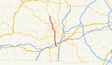
Route 56 is a north–south state highway running 20.1 miles (32.3 km) through central Worcester County
, Massachusetts
.
. It crosses the French River
before meeting U.S. Route 20
. It continues north, passing under I-90
(the Mass Pike) without access between the two. (The nearest access to the Pike is in Auburn
.) Route 56 then crosses the French River again before entering the town of Leicester
. It follows the Huntoon Memorial Highway until turning right onto Pleasant Street, following that street into the center of town, intersecting Route 9 just before turning north, passing Becker College
in the process.
Route 56 continues northward, passing several of the Kettle Brook Reservoirs as it enters Paxton
. In Paxton, Route 56 begins a 1.3 miles (2.1 km) concurrency with Route 122 which takes it into the center of Paxton. At the intersection of Route 122 and Route 31, Route 56 joins Route 31 northbound for less than a tenth of a mile before the two split, with Route 56 heading northward. The route then enters the town of Rutland
, passing northward towards that town's center. The route has a 0.1 mile (0.160934 km) concurrency with Route 122A
through the town center before turning northward again, ending at Route 68
near the Hubbardston
town line.
Worcester County, Massachusetts
-Demographics:In 1990 Worcester County had a population of 709,705.As of the census of 2000, there were 750,963 people, 283,927 households, and 192,502 families residing in the county. The population density was 496 people per square mile . There were 298,159 housing units at an average density...
, Massachusetts
Massachusetts
The Commonwealth of Massachusetts is a state in the New England region of the northeastern United States of America. It is bordered by Rhode Island and Connecticut to the south, New York to the west, and Vermont and New Hampshire to the north; at its east lies the Atlantic Ocean. As of the 2010...
.
Route description
Route 56 begins at Route 12 in North OxfordOxford, Massachusetts
Oxford is a town in Worcester County, Massachusetts, United States. The population was 13,709 at the 2010 census.For geographic and demographic information on the census-designated place Oxford, please see the article Oxford , Massachusetts.-History:...
. It crosses the French River
French River (Massachusetts)
The French River is a river in south-central Massachusetts and northeastern Connecticut.The river rises near Leicester, Massachusetts, and flows generally southwards through Auburn, Oxford, and Dudley; it then enters Connecticut where it joins the Quinebaug River at Thompson, just northeast of Putnam...
before meeting U.S. Route 20
U.S. Route 20 in Massachusetts
The cross-country U.S. Route 20 runs its easternmost in the U.S. state of Massachusetts. The highway crosses the state border from New Lebanon, New York into Hancock, Massachusetts, and runs eastward into Boston, where it ends at Route 2 in Kenmore Square...
. It continues north, passing under I-90
Massachusetts Turnpike
The Massachusetts Turnpike is the easternmost stretch of Interstate 90. The Turnpike begins at the western border of Massachusetts in West Stockbridge connecting with the Berkshire Connector portion of the New York State Thruway...
(the Mass Pike) without access between the two. (The nearest access to the Pike is in Auburn
Auburn, Massachusetts
Auburn is a town in Worcester County, Massachusetts, United States. The population was 16,188 at the 2010 census.- History :Auburn was first settled in 1789 and was officially incorporated in 1808 as the town of Ward, in honor of American Revolution General Artemas Ward...
.) Route 56 then crosses the French River again before entering the town of Leicester
Leicester, Massachusetts
Leicester is a town in Worcester County, Massachusetts, United States. The population was 10,970 at the 2010 census.-History:Leicester was first settled in 1713 and was officially incorporated in 1714....
. It follows the Huntoon Memorial Highway until turning right onto Pleasant Street, following that street into the center of town, intersecting Route 9 just before turning north, passing Becker College
Becker College
Becker College is a college in Massachusetts, United States with campuses in Worcester and Leicester. Established in 1887, Becker College is home to two distinct campuses located in Worcester and Leicester, Massachusetts...
in the process.
Route 56 continues northward, passing several of the Kettle Brook Reservoirs as it enters Paxton
Paxton, Massachusetts
Paxton is a town in Worcester County, Massachusetts, United States. The population was 4,806 at the 2010 census.-History:Paxton was first settled in 1749 and was officially incorporated in 1765....
. In Paxton, Route 56 begins a 1.3 miles (2.1 km) concurrency with Route 122 which takes it into the center of Paxton. At the intersection of Route 122 and Route 31, Route 56 joins Route 31 northbound for less than a tenth of a mile before the two split, with Route 56 heading northward. The route then enters the town of Rutland
Rutland, Massachusetts
Rutland is a town in Worcester County, Massachusetts, United States. The population was 7,973 at the 2010 census. Worcester County's only buffalo herd is located in Rutland, at Alta Vista Farm...
, passing northward towards that town's center. The route has a 0.1 mile (0.160934 km) concurrency with Route 122A
Massachusetts Route 122A
Route 122A is a southeast-northwest state highway in Massachusetts. It is an alternate route of Massachusetts Route 122, with a mile-long concurrency with its parent route in downtown Worcester.-Route description:...
through the town center before turning northward again, ending at Route 68
Massachusetts Route 68
-Route description:Route 68 begins in the Jefferson section of the town of Holden, at Route 122A. It heads northward into Rutland, passing through the northeastern part of the town, passing the northern end of Route 56...
near the Hubbardston
Hubbardston, Massachusetts
Hubbardston is a town in Worcester County, Massachusetts, United States. As of the 2010 U.S. census, the town population was 4,382.- History :...
town line.
Junction list
| County | Location | Mile | Roads intersected | Notes |
|---|---|---|---|---|
| Worcester Worcester County, Massachusetts -Demographics:In 1990 Worcester County had a population of 709,705.As of the census of 2000, there were 750,963 people, 283,927 households, and 192,502 families residing in the county. The population density was 496 people per square mile . There were 298,159 housing units at an average density... |
Oxford Oxford, Massachusetts Oxford is a town in Worcester County, Massachusetts, United States. The population was 13,709 at the 2010 census.For geographic and demographic information on the census-designated place Oxford, please see the article Oxford , Massachusetts.-History:... |
0.0 |  Route 12 Route 12 |
Southern end of Route 56. |
| 0.5 |  U.S. Route 20 U.S. Route 20U.S. Route 20 in Massachusetts The cross-country U.S. Route 20 runs its easternmost in the U.S. state of Massachusetts. The highway crosses the state border from New Lebanon, New York into Hancock, Massachusetts, and runs eastward into Boston, where it ends at Route 2 in Kenmore Square... |
|||
| 1.5 |  I-90/Mass Pike I-90/Mass PikeMassachusetts Turnpike The Massachusetts Turnpike is the easternmost stretch of Interstate 90. The Turnpike begins at the western border of Massachusetts in West Stockbridge connecting with the Berkshire Connector portion of the New York State Thruway... |
No access from Route 56 to I-90. | ||
| Leicester Leicester, Massachusetts Leicester is a town in Worcester County, Massachusetts, United States. The population was 10,970 at the 2010 census.-History:Leicester was first settled in 1713 and was officially incorporated in 1714.... |
6.3 |  Route 9 Route 9 |
||
| Paxton Paxton, Massachusetts Paxton is a town in Worcester County, Massachusetts, United States. The population was 4,806 at the 2010 census.-History:Paxton was first settled in 1749 and was officially incorporated in 1765.... |
10.2 |  Route 122 South Route 122 South |
Begin concurrency with Route 122. | |
| 11.5 | Route 122 North Route 31 South Route 31 South |
End concurrency with Route 122. Begin concurrency with Route 31. |
||
| 11.6 | Route 31 North |
End concurrency with Route 31. | ||
| Rutland Rutland, Massachusetts Rutland is a town in Worcester County, Massachusetts, United States. The population was 7,973 at the 2010 census. Worcester County's only buffalo herd is located in Rutland, at Alta Vista Farm... |
16.4 |  Route 122A Route 122AMassachusetts Route 122A Route 122A is a southeast-northwest state highway in Massachusetts. It is an alternate route of Massachusetts Route 122, with a mile-long concurrency with its parent route in downtown Worcester.-Route description:... South |
Begin concurrency with Route 122A. | |
| 16.5 | Route 122A Massachusetts Route 122A Route 122A is a southeast-northwest state highway in Massachusetts. It is an alternate route of Massachusetts Route 122, with a mile-long concurrency with its parent route in downtown Worcester.-Route description:... North |
End concurrency with Route 122A. | ||
| 20.1 |  Route 68 Route 68Massachusetts Route 68 -Route description:Route 68 begins in the Jefferson section of the town of Holden, at Route 122A. It heads northward into Rutland, passing through the northeastern part of the town, passing the northern end of Route 56... |
Northern end of Route 56. |