
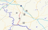
Maryland Route 67
Encyclopedia
Maryland Route 67 is a state highway
in the U.S. state
of Maryland
. Known as Rohrersville Road, the state highway runs 12.2 miles (19.6 km) from U.S. Route 340
(US 340) in Weverton
north to US 40 Alternate in Boonsboro
. MD 67 parallels the western flank of South Mountain
in southeastern Washington County
, connecting Boonsboro with Weverton and Rohrersville
. In conjunction with US 340 and US 40 Atlernate, MD 67 connects Hagerstown
and Harpers Ferry, West Virginia
, a link that made the highway one of the original state roads marked for improvement in 1909. The first section of the state highway was constructed through Rohrersville around 1920. The remainder of the highway was built between Boonsboro and Weverton in the late 1920s and early 1930s. MD 67 was reconstructed with multiple relocations starting in the late 1950s, culminating in a relocation at the southern terminus to tie into the US 340 freeway in the late 1960s.
near Harpers Ferry. The state highway crosses Israel Creek and heads north through a mix of farmland and forest within the Pleasant Valley, the valley of Israel Creek between Elk Ridge to the west and South Mountain to the east. Just north of Israel Creek, MD 67 intersects unsigned MD 67D, a connector east to Weverton Road, the old alignment of MD 67. Within the hamlet of Garretts Mill, the state highway intersects Garretts Mill Road, which heads west toward the Robert Clagett Farm
and the Magnolia Plantation
, and receives the other end of Weverton Road, which is accessed via MD 67E. MD 67 passes along the edge of Brownsville
, which is served by the old alignment, Boteler Road.
MD 67 continues north through the village of Gapland
. The old alignment of MD 67, Gapland Road, heads northwest into the heart of the village. Gapland Road heads east to Crampton's Gap
, a mountain pass through South Mountain that provides access to Burkittsville
in the Middletown Valley
. Crampton's Gap is the site of the Battle of Crampton's Gap
and Gathland State Park
. North of Gapland, Trego Road splits to the northwest toward Trego
, Eakles Mills
, and Keedysville
. The valley widens as MD 67 approaches Rohrersville. Main Street, which is unsigned MD 858
, serves the village while MD 67 bypasses it to the east, crossing Little Antietam Creek. MD 67 continues north, paralleled on the east by its old alignment of Woodstock Lane while passes to the west of the hamlet of Park Hall
, which contains Kefauver Place
. Another section of old alignment, Mount Carmel Church Road, which leads to the Nicodemus Mill Complex
, loops to the west as MD 67 crosses Dog Creek. The state highway passes two more segments of old alignment, both named Appletown Road, before reaching its northern terminus at US 40 Alternate (Boonsboro Pike) just south of Boonsboro.
MD 67 was reconstructed from Boonsboro to Gapland starting in the late 1950s, leaving behind several sections of old alignment that were designated sections of MD 858. Two of these sections, Main Street in Rohrersville (now MD 858F) and Mount Carmel Church Road north of Rohrersville, were bypassed in 1959. The southern terminus of MD 67 was relocated when US 340 was relocated as a four-lane divided highway through Weverton in 1964. Portions of MD 67 through Brownsville and Weverton were bypassed concurrent with the construction of MD 67's trumpet interchange around 1969.
.
{| class=wikitable
!Location
!Mile
!Road
!Notes
|-
|Weverton
|0.00
|
|Southern terminus; trumpet interchange
|-
|Gapland
|5.10
|Gapland Road east – Gathland State Park
|Former MD 572
|-
|rowspan=2|Rohrersville
|7.15
|
|rowspan=2|Officially MD 858F; old alignment of MD 67
|-
|8.10
|
|-
|Boonsboro
|12.20
|
|Northern terminus
State highway
State highway, state road or state route can refer to one of three related concepts, two of them related to a state or provincial government in a country that is divided into states or provinces :#A...
in the U.S. state
U.S. state
A U.S. state is any one of the 50 federated states of the United States of America that share sovereignty with the federal government. Because of this shared sovereignty, an American is a citizen both of the federal entity and of his or her state of domicile. Four states use the official title of...
of Maryland
Maryland
Maryland is a U.S. state located in the Mid Atlantic region of the United States, bordering Virginia, West Virginia, and the District of Columbia to its south and west; Pennsylvania to its north; and Delaware to its east...
. Known as Rohrersville Road, the state highway runs 12.2 miles (19.6 km) from U.S. Route 340
U.S. Route 340 in Maryland
U.S. Route 340 is a part of the U.S. Highway System that runs from Greenville, Virginia to Frederick, Maryland. In Maryland, the U.S. highway runs from the Virginia state line at the Potomac River at Sandy Hook east to its northern terminus at US 15 and US 40 in Frederick...
(US 340) in Weverton
Weverton, Maryland
Weverton is an unincorporated hamlet located in the southern tip of Washington County, Maryland, near the north shore of the Potomac River. Its population is approximately 500. Weverton is located at the intersection of MD Route 67 and U.S. Route 340...
north to US 40 Alternate in Boonsboro
Boonsboro, Maryland
Boonsboro is a town in Washington County, Maryland, United States, located at the foot of South Mountain. It nearly borders Frederick County and is proximate to the Antietam National Battlefield...
. MD 67 parallels the western flank of South Mountain
South Mountain (Maryland and Pennsylvania)
South Mountain is the northern extension of the Blue Ridge Mountain range in Maryland and Pennsylvania. From the Potomac River near Knoxville, Maryland in the south, to Dillsburg, Pennsylvania in the north, the long range separates the Hagerstown and Cumberland valleys from the Piedmont regions of...
in southeastern Washington County
Washington County, Maryland
Washington County is a county located in the western part of the U.S. state of Maryland, bordering southern Pennsylvania to the north, northern Virginia to the south, and the Eastern Panhandle of West Virginia to the south and west. As of the 2010 Census, its population is 147,430...
, connecting Boonsboro with Weverton and Rohrersville
Rohrersville, Maryland
Rohrersville is a census-designated place in Washington County, Maryland, United States. The population was 170 at the 2000 census.-Geography:Rohrersville is located at ....
. In conjunction with US 340 and US 40 Atlernate, MD 67 connects Hagerstown
Hagerstown, Maryland
Hagerstown is a city in northwestern Maryland, United States. It is the county seat of Washington County, and, by many definitions, the largest city in a region known as Western Maryland. The population of Hagerstown city proper at the 2010 census was 39,662, and the population of the...
and Harpers Ferry, West Virginia
Harpers Ferry, West Virginia
Harpers Ferry is a historic town in Jefferson County, West Virginia, United States. In many books the town is called "Harper's Ferry" with an apostrophe....
, a link that made the highway one of the original state roads marked for improvement in 1909. The first section of the state highway was constructed through Rohrersville around 1920. The remainder of the highway was built between Boonsboro and Weverton in the late 1920s and early 1930s. MD 67 was reconstructed with multiple relocations starting in the late 1950s, culminating in a relocation at the southern terminus to tie into the US 340 freeway in the late 1960s.
Route description
MD 67 begins at a trumpet interchange with US 340 (Jefferson Pike) in Weverton within the Potomac Water GapPotomac Water Gap
The Potomac Water Gap is a double water gap in the Blue Ridge Mountains, located at the intersection of the states of Virginia, West Virginia and Maryland, near Harpers Ferry...
near Harpers Ferry. The state highway crosses Israel Creek and heads north through a mix of farmland and forest within the Pleasant Valley, the valley of Israel Creek between Elk Ridge to the west and South Mountain to the east. Just north of Israel Creek, MD 67 intersects unsigned MD 67D, a connector east to Weverton Road, the old alignment of MD 67. Within the hamlet of Garretts Mill, the state highway intersects Garretts Mill Road, which heads west toward the Robert Clagett Farm
Robert Clagett Farm
The Robert Clagett Farm is a historic home and farm located at Knoxville, Washington County, Maryland, United States. The house is a one-story sandstone structure measuring three bays long by two bays deep in the Georgian-style. The house features a two-story galleried porch and an interior stone...
and the Magnolia Plantation
Magnolia Plantation (Knoxville, Maryland)
Magnolia Plantation, also known as the Boteler-Holder Farm, is a historic home located at Knoxville, Washington County, Maryland, United States. It is a 2-story, five-bay-wide house built about 1835, with a -story three-bay rear addition, set on finely coursed local fieldstone foundations...
, and receives the other end of Weverton Road, which is accessed via MD 67E. MD 67 passes along the edge of Brownsville
Brownsville, Maryland
Brownsville is a small unincorporated community in Washington County, Maryland, United States, near Gapland in an area known as Pleasant Valley.-Geography:...
, which is served by the old alignment, Boteler Road.
MD 67 continues north through the village of Gapland
Gapland, Maryland
Gapland is an unincorporated community in Washington County, Maryland, United States.-References:...
. The old alignment of MD 67, Gapland Road, heads northwest into the heart of the village. Gapland Road heads east to Crampton's Gap
Crampton's Gap
Crampton's Gap, also known as Crampton Gap, is a wind gap on South Mountain in Maryland.The gap connects Burkittsville in the Middletown Valley to the east with Gapland and Rohrersville in the Pleasant Valley to the west....
, a mountain pass through South Mountain that provides access to Burkittsville
Burkittsville, Maryland
Burkittsville is a town in Frederick County, Maryland, United States. The population was 171 at the 2000 census.-Geography:Burkittsville is located at ....
in the Middletown Valley
Middletown Valley
Middletown Valley, also historically known as Catoctin Valley, is a valley in western Frederick County in the state of Maryland.-Geography:...
. Crampton's Gap is the site of the Battle of Crampton's Gap
Battle of Crampton's Gap
The Battle of Crampton's Gap or Battle of Burkittsville was a battle fought between forces under Confederate Brig. Gen. Howell Cobb and Union Maj. Gen. William B...
and Gathland State Park
Gathland State Park
Gathland State Park is a small state park located near Burkittsville, Maryland, in the United States. The park is composed of the remains of the estate of George Alfred Townsend , a correspondent during the American Civil War who wrote under the pen name "Gath"...
. North of Gapland, Trego Road splits to the northwest toward Trego
Trego, Maryland
Trego is an unincorporated community in Washington County, Maryland, United States.-References:...
, Eakles Mills
Eakles Mills, Maryland
Eakles Mills is an unincorporated community in Washington County, Maryland, United States.-References:...
, and Keedysville
Keedysville, Maryland
Keedysville is a town in Washington County, Maryland, United States. The population was 482 as of the 2000 Census. As of 1 July 2008, the U.S. Census Bureau estimated the town's population at 862, a 78.8% increase from 2000.-Geography:...
. The valley widens as MD 67 approaches Rohrersville. Main Street, which is unsigned MD 858
Maryland Route 858
Maryland Route 858 is a collection of unsigned state highways in the U.S. state of Maryland. These four highways are service roads constructed or old alignments maintained to provide access to private property or county highways whose access was compromised by the reconstruction of MD 67 in...
, serves the village while MD 67 bypasses it to the east, crossing Little Antietam Creek. MD 67 continues north, paralleled on the east by its old alignment of Woodstock Lane while passes to the west of the hamlet of Park Hall
Park Hall, Washington County, Maryland
Park Hall is an unincorporated community in Washington County, Maryland, United States. Park Hall is southeast of Keedysville....
, which contains Kefauver Place
Kefauver Place
Kefauver Place is a historic farm complex located at Rohrersville, Washington County, Maryland, United States. It includes a log cabin built about 1820; a log barn of about 1830 with later-19th century additions; a 19th century timber-framed corn crib; a two-story brick house constructed around...
. Another section of old alignment, Mount Carmel Church Road, which leads to the Nicodemus Mill Complex
Nicodemus Mill Complex
Nicodemus Mill Complex is a historic home and mill complex located at Keedysville, Washington County, Maryland, United States. It consists of a dated 1810 -story, five-bay stone house with a mid-19th-century brick service wing, the ruins of a grist mill built about 1829, and an extensive complement...
, loops to the west as MD 67 crosses Dog Creek. The state highway passes two more segments of old alignment, both named Appletown Road, before reaching its northern terminus at US 40 Alternate (Boonsboro Pike) just south of Boonsboro.
History
The highway from Weverton to Boonsboro was marked for improvement by the Maryland State Roads Commission as one of the original state roads in 1909. However, by 1915, the uncompleted highway was deemed as not forming a necessary part of the main arterial system. The first section of MD 67 to be improved was Main Street through Rohrersville, which was paved by 1921. The modern road was extended north to Boonsboro in 1925 and 1926. Construction began on MD 67 from Rohrersville to Gapland in 1926 and was completed in 1928. The paved highway was extended through Brownsville to north of Garretts Mill in 1929 and 1930. The southern end of pavement remained north of Garretts Mill until the modern road was extended south through Weverton to US 340 in 1934 and 1935.MD 67 was reconstructed from Boonsboro to Gapland starting in the late 1950s, leaving behind several sections of old alignment that were designated sections of MD 858. Two of these sections, Main Street in Rohrersville (now MD 858F) and Mount Carmel Church Road north of Rohrersville, were bypassed in 1959. The southern terminus of MD 67 was relocated when US 340 was relocated as a four-lane divided highway through Weverton in 1964. Portions of MD 67 through Brownsville and Weverton were bypassed concurrent with the construction of MD 67's trumpet interchange around 1969.
Junction list
The entire route is in Washington CountyWashington County, Maryland
Washington County is a county located in the western part of the U.S. state of Maryland, bordering southern Pennsylvania to the north, northern Virginia to the south, and the Eastern Panhandle of West Virginia to the south and west. As of the 2010 Census, its population is 147,430...
.
{| class=wikitable
!Location
!Mile
!Road
!Notes
|-
|Weverton
Weverton, Maryland
Weverton is an unincorporated hamlet located in the southern tip of Washington County, Maryland, near the north shore of the Potomac River. Its population is approximately 500. Weverton is located at the intersection of MD Route 67 and U.S. Route 340...
|0.00
|
|Southern terminus; trumpet interchange
|-
|Gapland
Gapland, Maryland
Gapland is an unincorporated community in Washington County, Maryland, United States.-References:...
|5.10
|Gapland Road east – Gathland State Park
Gathland State Park
Gathland State Park is a small state park located near Burkittsville, Maryland, in the United States. The park is composed of the remains of the estate of George Alfred Townsend , a correspondent during the American Civil War who wrote under the pen name "Gath"...
|Former MD 572
|-
|rowspan=2|Rohrersville
Rohrersville, Maryland
Rohrersville is a census-designated place in Washington County, Maryland, United States. The population was 170 at the 2000 census.-Geography:Rohrersville is located at ....
|7.15
|
|rowspan=2|Officially MD 858F; old alignment of MD 67
|-
|8.10
|
|-
|Boonsboro
Boonsboro, Maryland
Boonsboro is a town in Washington County, Maryland, United States, located at the foot of South Mountain. It nearly borders Frederick County and is proximate to the Antietam National Battlefield...
|12.20
|
|Northern terminus
Auxiliary routes
- MD 67A is the designation for an unnamed 0.08 mile (0.1287472 km) one-lane cut-off of old alignment between southbound MD 67 and the north end of MD 858F (Main Street) in Rohrersville.
- MD 67B is the designation for an unnamed 0.09 mile (0.1448406 km) spur of old alignment north from the northern end of Gapland Road on the southbound side of MD 67 in Gapland.
- MD 67C is the designation for a 0.03 mile (0.0482802 km) section of Boteler Road at its northern junction with MD 67 in Brownsville.
- MD 67D is the designation for Weverton Road, a 0.31 mile (0.4988954 km) connector from MD 67 just north of US 340 to near the southern end of the old alignment of MD 67, also named Weverton Road, in Weverton.
- MD 67E is the designation for Weverton Road, a 0.04 mile (0.0643736 km) connector from MD 67 to near the northern end of Weverton Road north of Weverton.
- MD 67F is the designation for the unnamed 0.09 mile (0.1448406 km) access road from MD 67 to Pleasant Valley Elementary School between Weverton and Brownsville.