
Maryland Route 564
Encyclopedia
Maryland Route 564 is a state highway
in the U.S. state
of Maryland
. Known for most of its length as Lanham Severn Road, the state highway runs 6.73 mi (10.8 km) from MD 450
in Lanham
east to a dead end near a connection to MD 197
in Bowie
.
's Penn Line
at a distance. The state highway crosses Baldhill Branch and passes through the unincorporated community of Seabrook
, where the road intersects Seabrook Road and passes the Seabrook
MARC station. After passing through a commercial area in Seabrook, MD 564 passes several industrial properties on the railroad side of the highway. The state highway enters Glenn Dale
, where the highway temporarily expands to a four-lane divided highway for intersections with Glenn Dale Road (unsigned MD 953A) and MD 193
(Glenn Dale Boulevard).
MD 564 continues northeast, passing Hillmeade Road and Springfield Road before entering the city of Bowie, where the highway's name changes to 9th Street. At Chestnut Avenue, which is unsigned MD 564A, the state highway assumes that street's name and turns south to cross the Amtrak Northeast Corridor just north of its junction with CSX
's Popes Creek Subdivision
. MD 564 turns east onto 11st Street, which heads west toward the railroad wye as unsigned MD 564C. After passing Race Track Road, which heads east toward an intersection with MD 197 (Laurel–Bowie Road), MD 564 curves south and reaches its southern terminus at the entrance to a farm adjacent to the Washington, Baltimore and Annapolis Trail
's crossing of MD 197.
.
auxiliary routes in Bowie.
State highway
State highway, state road or state route can refer to one of three related concepts, two of them related to a state or provincial government in a country that is divided into states or provinces :#A...
in the U.S. state
U.S. state
A U.S. state is any one of the 50 federated states of the United States of America that share sovereignty with the federal government. Because of this shared sovereignty, an American is a citizen both of the federal entity and of his or her state of domicile. Four states use the official title of...
of Maryland
Maryland
Maryland is a U.S. state located in the Mid Atlantic region of the United States, bordering Virginia, West Virginia, and the District of Columbia to its south and west; Pennsylvania to its north; and Delaware to its east...
. Known for most of its length as Lanham Severn Road, the state highway runs 6.73 mi (10.8 km) from MD 450
Maryland Route 450
Maryland Route 450 is a state highway in the U.S. state of Maryland. The state highway runs from U.S. Route 1 Alternate in Bladensburg east to US 50, US 301, and MD 2 near Annapolis. MD 450 is the original alignment of US 50 in Prince George's and Anne Arundel Counties...
in Lanham
Lanham, Maryland
Lanham is an unincorporated community in Prince George's County in the State of Maryland in the United States of America. Because it is not formally incorporated, it has no official boundaries, but the United States Census Bureau has defined a census-designated place consisting of Lanham and the...
east to a dead end near a connection to MD 197
Maryland Route 197
Maryland Route 197 is a state highway in the U.S. state of Maryland. Known for most of its length as Laurel–Bowie Road, the state highway runs from U.S. Route 301 in Bowie north to MD 198 in Laurel. In addition to being the main connection between Bowie and Laurel, MD 197 provides access...
in Bowie
Bowie, Maryland
Bowie is a city in Prince George's County, Maryland, United States. The population was 54,727 at the 2010 census. Bowie has grown from a small railroad stop to the largest municipality in Prince George's County, and the fifth most populous city and third largest city by area in the state of...
.
Route description
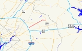
MD 564 begins at a partial interchange with MD 450 (Annapolis Road) in Lanham. There is no access from westbound MD 450 to eastbound MD 564 or from westbound MD 564 to eastbound MD 450. Eastbound MD 564 exits from eastbound MD 450, passes under MD 450, and meets westbound MD 564 at an intersection where heading straight leads to Cipriano Road. The two directions of MD 564 come together as Lanham Severn Road, a two-lane road heading northeast paralleling the Amtrak Northeast Corridor and MARCMARC Train
MARC , known prior to 1984 as Maryland Rail Commuter Service, is a regional rail system comprising three lines in the Baltimore-Washington Metropolitan Area. MARC is administered by the Maryland Transit Administration , a Maryland Department of Transportation agency, and is operated under contract...
's Penn Line
Penn Line (MARC)
The Penn Line is a MARC commuter rail line running from Union Station, Washington D.C. to Perryville, Maryland via Penn Station, Baltimore, Maryland on Amtrak's Northeast Corridor. It is MARC's busiest and only electric line. Currently the line is the fastest commuter rail line in the country, with...
at a distance. The state highway crosses Baldhill Branch and passes through the unincorporated community of Seabrook
Seabrook, Maryland
Seabrook is an unincorporated community located in central Maryland about east of Washington DC.According to the 2000 census, the population of Lanham-Seabrook is 18,190...
, where the road intersects Seabrook Road and passes the Seabrook
Seabrook (MARC station)
Seabrook is a station on MARC's Penn Line, a commuter rail line conntecting Washington, D.C. and Baltimore, in Seabrook, Maryland. It is located at 6221 Seabrook Road south of Lanham Severn Road in Seabrook, Maryland, although MARC gives the location as being in Lanham, Maryland. The station is...
MARC station. After passing through a commercial area in Seabrook, MD 564 passes several industrial properties on the railroad side of the highway. The state highway enters Glenn Dale
Glenn Dale, Maryland
Glenn Dale is an unincorporated area and census-designated place in Prince George's County, Maryland, United States. The population was 12,609 at the 2000 census...
, where the highway temporarily expands to a four-lane divided highway for intersections with Glenn Dale Road (unsigned MD 953A) and MD 193
Maryland Route 193
Maryland Route 193 is a state highway in the U.S. state of Maryland. Known for most of its length as University Boulevard and Greenbelt Road, the state highway runs from MD 185 in Kensington east to MD 202 in Greater Upper Marlboro...
(Glenn Dale Boulevard).
MD 564 continues northeast, passing Hillmeade Road and Springfield Road before entering the city of Bowie, where the highway's name changes to 9th Street. At Chestnut Avenue, which is unsigned MD 564A, the state highway assumes that street's name and turns south to cross the Amtrak Northeast Corridor just north of its junction with CSX
CSX Transportation
CSX Transportation operates a Class I railroad in the United States known as the CSX Railroad. It is the main subsidiary of the CSX Corporation. The company is headquartered in Jacksonville, Florida, and owns approximately 21,000 route miles...
's Popes Creek Subdivision
Popes Creek Subdivision
The Pope's Creek Subdivision is a CSX Transportation railroad line in Maryland, running from Bowie to Morgantown and the Chalk Point Generating Station.- History :...
. MD 564 turns east onto 11st Street, which heads west toward the railroad wye as unsigned MD 564C. After passing Race Track Road, which heads east toward an intersection with MD 197 (Laurel–Bowie Road), MD 564 curves south and reaches its southern terminus at the entrance to a farm adjacent to the Washington, Baltimore and Annapolis Trail
Washington, Baltimore and Annapolis Trail
The Washington, Baltimore and Annapolis Trail is a long discontinuous rail trail from Lanham to Odenton in Maryland. Despite its name, it does not actually connect with Washington, D.C., Annapolis or Baltimore; its name is taken from the Washington, Baltimore and Annapolis Electric Railway, from...
's crossing of MD 197.
Junction list
The entire route is in Prince George's CountyPrince George's County, Maryland
Prince George's County is a county located in the U.S. state of Maryland, immediately north, east, and south of Washington, DC. As of 2010, it has a population of 863,420 and is the wealthiest African-American majority county in the nation....
.
| Location | Mile |
Destinations | Notes |
|---|---|---|---|
| Lanham Lanham, Maryland Lanham is an unincorporated community in Prince George's County in the State of Maryland in the United States of America. Because it is not formally incorporated, it has no official boundaries, but the United States Census Bureau has defined a census-designated place consisting of Lanham and the... |
0.00 | Western terminus; partial interchange with no access from westbound MD 450 to eastbound MD 564 | |
| 0.31 | / Cipriano Road north – Greenbelt Greenbelt, Maryland Greenbelt is a city in Prince George's County, Maryland, United States. Contained within today's City of Greenbelt is the historic planned community now known locally as "Old Greenbelt" and designated as the Greenbelt Historic District... |
U-turn from eastbound MD 564 to westbound MD 564 | |
| Glenn Dale Glenn Dale, Maryland Glenn Dale is an unincorporated area and census-designated place in Prince George's County, Maryland, United States. The population was 12,609 at the 2000 census... |
2.93 | Glenn Dale Road | Old alignment of MD 193; unsigned MD 953A |
| 3.04 | |||
| Bowie Bowie, Maryland Bowie is a city in Prince George's County, Maryland, United States. The population was 54,727 at the 2010 census. Bowie has grown from a small railroad stop to the largest municipality in Prince George's County, and the fifth most populous city and third largest city by area in the state of... |
5.60 | Chestnut Avenue north | MD 564 turns south onto Chestnut Avenue; unsigned MD 564A; old alignment of MD 197 |
| 5.71 | 11th Street west | MD 564 turns east onto 11th Street; unsigned MD 564C | |
| 6.35 | Race Track Road east to | Former MD 703 | |
| 6.73 | Road end | Eastern terminus |
Auxiliary routes
MD 564 has three unsignedUnsigned highway
An unsigned highway is a highway that has been assigned a route number, but does not bear conventional road markings that would normally be used to identify the route with that number...
auxiliary routes in Bowie.
- MD 564A is the designation for a 0.06 mile (0.0965604 km) section of Chestnut Avenue that connects MD 564 to the county-maintained portion of the street on the north side of the Amtrak Northeast Corridor.
- MD 564B is the designation for Chestnut Street, a 0.04 mile (0.0643736 km) section of old alignment of MD 197 from MD 564C north to a dead end adjacent to the Huntington Railroad Museum on the south side of the Amtrak Northeast Corridor.
- MD 564C is the designation for a 0.02 mile (0.0321868 km) section of 11th Street that connects the county-maintained portion of Chestnut Avenue with MD 564 on the south side of the Amtrak Northeast Corridor.