
Maryland Route 174
Encyclopedia
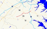
Maryland Route 174 is an east–west route located in Anne Arundel County
. Running just under six miles (10 km), it connects Maryland Route 3 Business in Glen Burnie, Maryland
with Fort Meade. Known locally as Quarterfield Road, Donaldson Avenue, and Reece Road, Route 174 provides a link between the business area around BWI Airport and the military community of the Fort Meade area near Odenton
, which the route draws close to but does not enter.
. While Reece Road's eastern terminus is at MD 713, the Maryland route designation begins at an intersection with Jacobs Road northwest of the town; the road south of there is owned by the U.S. government.
MD 174 and Reece Road continue northeast, following a two-lane road with full shoulders (as opposed to the shoulderless version owned by the government) and passes through a residential area, curving to the east. After it passes by a school building it turns north and passes through small agricultural fields, re-entering development just before it bridges the Amtrak Northeast Corridor, where the road narrows momentarily. It zigzags northward through the homes in Severn
as it meets Old Camp Meade Road, an older through street which has since been divided by the construction of the Northeast Corridor. The route then proceeds east and meets an intersection with Maryland Route 170
.
At this intersection, MD 174 dualizes
for a short stretch, its name changing to Donaldson Avenue and continues eastward further in much the same format as it was in before, passing through even more suburban neighborhoods. As it turns northeast, it intersects Quarterfield Road, widening to four lanes and taking on this name. MD 174, now as Quarterfield Road, passes by a large shopping center as it then interchanges with Interstate 97
. After this, it enters southeastern Glen Burnie
, where it interchanges with MD 100 as well, just before it ends at Maryland Route 3 Business (Crain Highway) near another school building.
.
Anne Arundel County, Maryland
Anne Arundel County is a county located in the U.S. state of Maryland. It is named for Anne Arundell , a member of the ancient family of Arundells in Cornwall, England and the wife of Cæcilius Calvert, 2nd Baron Baltimore. Its county seat is Annapolis, which is also the capital of the state...
. Running just under six miles (10 km), it connects Maryland Route 3 Business in Glen Burnie, Maryland
Glen Burnie, Maryland
Glen Burnie is a census-designated place in Anne Arundel County, Maryland, United States, and is a suburb of Baltimore. The population was 67,639 at the 2010 census...
with Fort Meade. Known locally as Quarterfield Road, Donaldson Avenue, and Reece Road, Route 174 provides a link between the business area around BWI Airport and the military community of the Fort Meade area near Odenton
Odenton, Maryland
Odenton is a census-designated place in Anne Arundel County, Maryland, United States. The population was 20,534 at the 2000 census. The town is named after former Governor of Maryland, Oden Bowie. It is bordered by Gambrills to the east, Severn to the north, Fort Meade to the west, and Crofton to...
, which the route draws close to but does not enter.
Route description
Maryland Route 174 begins along Reece Road in Fort MeadeFort Meade, Maryland
Fort Meade is a census-designated place in Anne Arundel County, Maryland, United States. The population was 9,882 at the 2000 census. It is the home to the National Security Agency, which is located on the US Army post Fort George G...
. While Reece Road's eastern terminus is at MD 713, the Maryland route designation begins at an intersection with Jacobs Road northwest of the town; the road south of there is owned by the U.S. government.
MD 174 and Reece Road continue northeast, following a two-lane road with full shoulders (as opposed to the shoulderless version owned by the government) and passes through a residential area, curving to the east. After it passes by a school building it turns north and passes through small agricultural fields, re-entering development just before it bridges the Amtrak Northeast Corridor, where the road narrows momentarily. It zigzags northward through the homes in Severn
Severn, Maryland
Severn is a census-designated place in Anne Arundel County, Maryland, United States. The population was 35,076 at the 2000 census, which is a 30 percent increase over the 24,499 population of 1990...
as it meets Old Camp Meade Road, an older through street which has since been divided by the construction of the Northeast Corridor. The route then proceeds east and meets an intersection with Maryland Route 170
Maryland Route 170
Maryland Route 170 is a roughly 13-mile-long road in Anne Arundel County.-Route description:MD 170 begins at the intersection of MD 175 Annapolis Road and Piney Orchard Parkway, in Odenton. It runs north towards Severn, interchanging with MD 32 northwest of the town...
.
At this intersection, MD 174 dualizes
Dual carriageway
A dual carriageway is a class of highway with two carriageways for traffic travelling in opposite directions separated by a central reservation...
for a short stretch, its name changing to Donaldson Avenue and continues eastward further in much the same format as it was in before, passing through even more suburban neighborhoods. As it turns northeast, it intersects Quarterfield Road, widening to four lanes and taking on this name. MD 174, now as Quarterfield Road, passes by a large shopping center as it then interchanges with Interstate 97
Interstate 97
Interstate 97 is an intrastate Interstate Highway located entirely within Anne Arundel County, Maryland, United States. It runs from Annapolis at the overlapped section of US 50, US 301, and the unsigned I-595 to Baltimore at the city's beltway...
. After this, it enters southeastern Glen Burnie
Glen Burnie, Maryland
Glen Burnie is a census-designated place in Anne Arundel County, Maryland, United States, and is a suburb of Baltimore. The population was 67,639 at the 2010 census...
, where it interchanges with MD 100 as well, just before it ends at Maryland Route 3 Business (Crain Highway) near another school building.
Junction list
The entire route is in Anne Arundel CountyAnne Arundel County, Maryland
Anne Arundel County is a county located in the U.S. state of Maryland. It is named for Anne Arundell , a member of the ancient family of Arundells in Cornwall, England and the wife of Cæcilius Calvert, 2nd Baron Baltimore. Its county seat is Annapolis, which is also the capital of the state...
.
| Location | Mile |
Intersection | Notes |
|---|---|---|---|
| Fort Meade Fort Meade, Maryland Fort Meade is a census-designated place in Anne Arundel County, Maryland, United States. The population was 9,882 at the 2000 census. It is the home to the National Security Agency, which is located on the US Army post Fort George G... |
0.00 | Jacobs Road West | Western terminus |
| Severn Severn, Maryland Severn is a census-designated place in Anne Arundel County, Maryland, United States. The population was 35,076 at the 2000 census, which is a 30 percent increase over the 24,499 population of 1990... |
2.48 | ||
| Glen Burnie Glen Burnie, Maryland Glen Burnie is a census-designated place in Anne Arundel County, Maryland, United States, and is a suburb of Baltimore. The population was 67,639 at the 2010 census... |
4.94 | I-97 exit 13 | |
| 5.18 | |||
| 5.63 | Interchange | ||
| 5.94 | Eastern terminus |