
Maryland Route 112
Encyclopedia
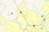
Maryland Route 112 is a Maryland
state highway
that goes between MD 28 in Darnestown
and MD 190
near Seneca
. The entire route is in Montgomery County
.
. It starts following Seneca Road, carrying a 45 mi/h speed limit as it travels east-northeast through what eventually becomes a large expanse of residential areas. The scenery along the road is very wooded in the west, which gives way to several agricultural fields in the east with the trees leaving after a short stretch (about one mile). It comes to an end at MD 28 in Darnestown
, where several stores rest at its eastern end.
.
Maryland
Maryland is a U.S. state located in the Mid Atlantic region of the United States, bordering Virginia, West Virginia, and the District of Columbia to its south and west; Pennsylvania to its north; and Delaware to its east...
state highway
State highway
State highway, state road or state route can refer to one of three related concepts, two of them related to a state or provincial government in a country that is divided into states or provinces :#A...
that goes between MD 28 in Darnestown
Darnestown, Maryland
Darnestown is a census-designated place and an unincorporated area in Montgomery County, Maryland, United States.-Geography:As an unincorporated area, Darnestown's boundaries are not officially defined...
and MD 190
Maryland Route 190
Maryland Route 190, or River Road, is a major state highway through southern Montgomery County, Maryland, United States.-Route description:MD 190 begins at MD 112's western terminus in Seneca, and ends at the Montgomery County/Washington, D.C. border...
near Seneca
Seneca, Maryland
Seneca is an unincorporated community in Montgomery County, Maryland, United States.-References:...
. The entire route is in Montgomery County
Montgomery County, Maryland
Montgomery County is a county in the U.S. state of Maryland, situated just to the north of Washington, D.C., and southwest of the city of Baltimore. It is one of the most affluent counties in the United States, and has the highest percentage of residents over 25 years of age who hold post-graduate...
.
Route description
Maryland Route 112 begins in the west at an intersection with the northern terminus of MD 190 near SenecaSeneca, Maryland
Seneca is an unincorporated community in Montgomery County, Maryland, United States.-References:...
. It starts following Seneca Road, carrying a 45 mi/h speed limit as it travels east-northeast through what eventually becomes a large expanse of residential areas. The scenery along the road is very wooded in the west, which gives way to several agricultural fields in the east with the trees leaving after a short stretch (about one mile). It comes to an end at MD 28 in Darnestown
Darnestown, Maryland
Darnestown is a census-designated place and an unincorporated area in Montgomery County, Maryland, United States.-Geography:As an unincorporated area, Darnestown's boundaries are not officially defined...
, where several stores rest at its eastern end.
Junction list
The entire route is in Montgomery CountyMontgomery County, Maryland
Montgomery County is a county in the U.S. state of Maryland, situated just to the north of Washington, D.C., and southwest of the city of Baltimore. It is one of the most affluent counties in the United States, and has the highest percentage of residents over 25 years of age who hold post-graduate...
.
| Location | Mile |
Roads intersected | Notes |
|---|---|---|---|
| Seneca | 0.00 | Western terminus | |
| Darnestown Darnestown, Maryland Darnestown is a census-designated place and an unincorporated area in Montgomery County, Maryland, United States.-Geography:As an unincorporated area, Darnestown's boundaries are not officially defined... |
2.81 | Eastern terminus |