

Maris Pacifici
Encyclopedia
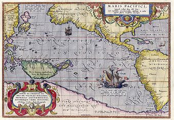
Maris Pacifici is more accurately named the Descriptio Maris Pacifici, Description of the Pacific Sea. It was the first dedicated map of the Pacific to be printed and is considered an important advancement in cartography
Cartography
Cartography is the study and practice of making maps. Combining science, aesthetics, and technique, cartography builds on the premise that reality can be modeled in ways that communicate spatial information effectively.The fundamental problems of traditional cartography are to:*Set the map's...
.
This map was drawn by Abraham Ortelius
Abraham Ortelius
thumb|250px|Abraham Ortelius by [[Peter Paul Rubens]]Abraham Ortelius thumb|250px|Abraham Ortelius by [[Peter Paul Rubens]]Abraham Ortelius (Abraham Ortels) thumb|250px|Abraham Ortelius by [[Peter Paul Rubens]]Abraham Ortelius (Abraham Ortels) (April 14, 1527 – June 28,exile in England to take...
in 1589, based upon a map of America
United States
The United States of America is a federal constitutional republic comprising fifty states and a federal district...
from the same year that was drawn by Frans Hogenberg. Some details of the map may have been influenced by a 1568 description of Japan
Japan
Japan is an island nation in East Asia. Located in the Pacific Ocean, it lies to the east of the Sea of Japan, China, North Korea, South Korea and Russia, stretching from the Sea of Okhotsk in the north to the East China Sea and Taiwan in the south...
in a manuscript by Vaz Dourado
Fernão Vaz Dourado
Fernão Vaz Dourado was a Portuguese cartographer of the sixteenth century, belonging to the third period of the old Portuguese nautical cartography, which is characterised by the abandonment of Ptolemaic influence in the representation of the Orient and introduction of better accuracy in the...
, rather than a map, hence its peculiar shape.
The land mass illustrated to the south of all of the Pacific and South America is a representation of Terra Australis
Terra Australis
Terra Australis, Terra Australis Ignota or Terra Australis Incognita was a hypothesized continent appearing on European maps from the 15th to the 18th century...
.