

Fernão Vaz Dourado
Encyclopedia
Portugal
Portugal , officially the Portuguese Republic is a country situated in southwestern Europe on the Iberian Peninsula. Portugal is the westernmost country of Europe, and is bordered by the Atlantic Ocean to the West and South and by Spain to the North and East. The Atlantic archipelagos of the...
cartographer
Cartography
Cartography is the study and practice of making maps. Combining science, aesthetics, and technique, cartography builds on the premise that reality can be modeled in ways that communicate spatial information effectively.The fundamental problems of traditional cartography are to:*Set the map's...
of the sixteenth century, belonging to the third period of the old Portuguese nautical cartography, which is characterised by the abandonment of Ptolemaic influence in the representation of the Orient and introduction of better accuracy in the depiction of lands and continents. Little is known about this historical figure.
The known works of Dourado are of an extraordinary quality and beauty. He is considered as one of the best cartographers of the time. Most of his manuscript charts are of relatively large scale and are included in nautical atlases. The following six atlas from the period 1568-1580 are known:
- 1568 - 20 manuscript sheets on parchment, dedicated to D. Luís de Ataíde (Biblioteca Nacional, Madrid)
- 1570 - 20 manuscript sheets on parchment (Huntington Library, San Marino, USA)
- 1571 - 20 manuscript sheets on parchment, two were stolen in the nineteenth century (Torre do Tombo, Lisbon)
- c. 1576 - 20 manuscript sheets on parchment (Biblioteca Nacional de Portugal, Lisbon)
- 1575 - 21 manuscript sheets on parchment (British Museum, London)
- 1580 - 20 manuscript sheets on parchment (Biblioteca Nacional de Portugal, Lisbon)
The 1568 atlas contains the first large-scale charts of Ceilão (Sri Lanka
Sri Lanka
Sri Lanka, officially the Democratic Socialist Republic of Sri Lanka is a country off the southern coast of the Indian subcontinent. Known until 1972 as Ceylon , Sri Lanka is an island surrounded by the Indian Ocean, the Gulf of Mannar and the Palk Strait, and lies in the vicinity of India and the...
) and Japan
Japan
Japan is an island nation in East Asia. Located in the Pacific Ocean, it lies to the east of the Sea of Japan, China, North Korea, South Korea and Russia, stretching from the Sea of Okhotsk in the north to the East China Sea and Taiwan in the south...
, later copied by many other cartographers.
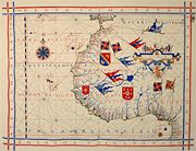
His chart of the northwestern coast of Africa
Africa
Africa is the world's second largest and second most populous continent, after Asia. At about 30.2 million km² including adjacent islands, it covers 6% of the Earth's total surface area and 20.4% of the total land area...
, displayed above is executed using the so-called "plain chart model", where observed latitudes and magnetic directions were plotted directly into the plane, with a constant scale, as if the Earth were flat. Until the adoption of the Mercator projection
Mercator projection
The Mercator projection is a cylindrical map projection presented by the Belgian geographer and cartographer Gerardus Mercator, in 1569. It became the standard map projection for nautical purposes because of its ability to represent lines of constant course, known as rhumb lines or loxodromes, as...
charting method, this was the most advanced charting method in Europe.