
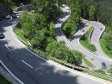
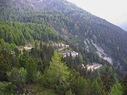
Maloja Pass
Encyclopedia
Mountain pass
A mountain pass is a route through a mountain range or over a ridge. If following the lowest possible route, a pass is locally the highest point on that route...
in the Swiss Alps
Swiss Alps
The Swiss Alps are the portion of the Alps mountain range that lies within Switzerland. Because of their central position within the entire Alpine range, they are also known as the Central Alps....
in the canton
Cantons of Switzerland
The 26 cantons of Switzerland are the member states of the federal state of Switzerland. Each canton was a fully sovereign state with its own borders, army and currency from the Treaty of Westphalia until the establishment of the Swiss federal state in 1848...
of Graubünden
Graubünden
Graubünden or Grisons is the largest and easternmost canton of Switzerland. The canton shares borders with the cantons of Ticino, Uri, Glarus and St. Gallen and international borders with Italy, Austria and Liechtenstein...
, linking the Engadin
Engadin
The Engadin or Engadine is a long valley in the Swiss Alps located in the canton of Graubünden in southeast Switzerland. It follows the route of the Inn River from its headwaters at Maloja Pass running northeast until the Inn flows into Austria one hundred kilometers downstream...
with the Val Bregaglia
Val Bregaglia
The Val Bregaglia or Bergell Tal is an alpine valley of Switzerland and Italy at the base of which runs the river Mera River...
and Chiavenna in Italy
Italy
Italy , officially the Italian Republic languages]] under the European Charter for Regional or Minority Languages. In each of these, Italy's official name is as follows:;;;;;;;;), is a unitary parliamentary republic in South-Central Europe. To the north it borders France, Switzerland, Austria and...
. It marks the watershed between the Danube and Po basins.
The road from Chiavenna to Silvaplana with distances and elevation
Elevation
The elevation of a geographic location is its height above a fixed reference point, most commonly a reference geoid, a mathematical model of the Earth's sea level as an equipotential gravitational surface ....
:
- 0 km Chiavenna 333 m
- 10 km CastasegnaCastasegnaCastasegna is a former municipality in the district of Maloja in the Swiss canton of Graubünden, right at the Italian border. It's now part of the municipality of Bregaglia. The town is situated in the Bergell valley, above the river Mera.-Geography:...
(Italian-Swiss border) 696 m - 13 km PromontognoPromontognoPromontogno is a town in Graubünden, Switzerland....
802 m - 16 km StampaStampaStampa is a former municipality in the Maloja district of the Swiss canton, Graubünden. It is now part of the municipality of Bregaglia.-Geography:Stampa has an area, , of . Of this area, 14.2% is used for agricultural purposes, while 18.8% is forested...
994 m - 18 km BorgonovoBorgonovoBorgonovo is a town in Graubünden, Switzerland.-Notable people:*Alberto Giacometti, artist, born in Borgonovo in 1901....
1029 m - 19 km VicosopranoVicosopranoVicosoprano is a former municipality in the district of Maloja in the Swiss canton of Graubünden, and is the largest village in the Val Bregaglia. It's now part of the municipality of Bregaglia.-Geography:...
1065 m - 27 km Casaccia 1458 m
- 32 km Maloja Pass 1815 m
- 33 km MalojaMalojaMaloja may refer to:* Maloja , an administrative district in the Swiss canton of Graubünden.* Maloja Pass, an alpine pass in the Swiss canton of Graubünden....
(village) 1809 m - 40 km Sils/Segl 1798 m
- 44 km SilvaplanaSilvaplanaSilvaplana is a municipality in the district of Maloja in the Swiss canton of Graubünden and the name of a lake in the municipality.-History:...
1802 m
Maloja pass is open in winter. However, after a snowfall the road may be closed for a couple of hours or for an entire day. Even if open, the road might be covered with snow—winter tires or chains would help.
See also
- List of highest paved roads in Europe
- List of mountain passes
- List of the highest Swiss passes