

Malian Gulf
Encyclopedia
Aegean Sea
The Aegean Sea[p] is an elongated embayment of the Mediterranean Sea located between the southern Balkan and Anatolian peninsulas, i.e., between the mainlands of Greece and Turkey. In the north, it is connected to the Marmara Sea and Black Sea by the Dardanelles and Bosporus...
in the region of Phthiotis
Phthiotis
Phthiotis is one of the regional units of Greece. It is part of the administrative region of Central Greece. The capital is the city of Lamia. It is bordered by the Malian Gulf to the east, Boeotia in the south, Phocis in the south, Aetolia-Acarnania in the southwest, Evrytania in the west,...
in eastern Central Greece
Central Greece
Continental Greece or Central Greece , colloquially known as Roúmeli , is a geographical region of Greece. Its territory is divided into the administrative regions of Central Greece, Attica, and part of West Greece...
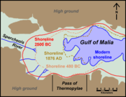
. The gulf is named after the ancient Malians who lived on its shores.
It stretches east to west to a distance of 15 to 22 km, depending on the definition. Due to the constant accretion of silt from the river the Spercheios and smaller streams, the gulf has been shrinking over the centuries and is very shallow, with a maximum depth is 27 m. Thus the ancient strait of Thermopylae
Thermopylae
Thermopylae is a location in Greece where a narrow coastal passage existed in antiquity. It derives its name from its hot sulphur springs. "Hot gates" is also "the place of hot springs and cavernous entrances to Hades"....
, which at the time the famous battle
Battle of Thermopylae
The Battle of Thermopylae was fought between an alliance of Greek city-states, led by King Leonidas of Sparta, and the Persian Empire of Xerxes I over the course of three days, during the second Persian invasion of Greece. It took place simultaneously with the naval battle at Artemisium, in August...
was fought, was delineated by Mount Kallidromo
Kallidromo
Kallidromo is a mountain in Central Greece in southeastern Phthiotis and northeasternmost Phocis. Its maximum elevation is 1,372 m. The GR-1 passes to the north and to the southwest and the west, the GR-3 as well as the narrow curve, the OSE line is also to the southwest and west. The Phokida...
and the Malian Gulf, has now become a broad coastal plain. The only harbour is that of Stylida
Stylida
Stylida is a town and a municipality in Phthiotis, Greece. The population of the municipal unit was 6,858 .-Municipality:The municipality Stylida was formed at the 2011 local government reform by the merger of the following 3 former municipalities, that became municipal...
, which serves the city of Lamia
Lamia (city)
Lamia is a city in central Greece. The city has a continuous history since antiquity, and is today the capital of the regional unit of Phthiotis and of the Central Greece region .-Name:...
. To its east is the northwesternmost point of the island of Euboea
Euboea
Euboea is the second largest Greek island in area and population, after Crete. The narrow Euripus Strait separates it from Boeotia in mainland Greece. In general outline it is a long and narrow, seahorse-shaped island; it is about long, and varies in breadth from to...
, Cape Lichada.