

Macquarie Harbour
Encyclopedia
Macquarie Harbour is a large, shallow, but navigable by shallow draft vessels inlet on the West Coast
of Tasmania
, Australia
.
wrote in his narrative "First Discovery of Port Davey and Macquarie Harbour" how he sailed from Hobart in a small open five-oared whaleboat to discover Macquarie Harbour on 28 December 1815.
However, different accounts of the journey have indicated different methods and dates of the discovery. In the commentary to the Historical Records of Australia, the editor notes that T.W. Birch stated before the commission of inquiry into the state of the colony in 1820 that Kelly had discovered Macquarie Harbour after proceeding along in a boat from Port Davey where they had travelled in the schooner Henrietta Packet. Kelly gave evidence before the commission, and did not mention any discoveries. In a letter dated 11 April 1816, preserved in the record office, London, T.W. Birch transmitted an account of this voyage, which records the discovery of Macquarie Harbour on 26 December 1815.
Charles Whitham
(see below, p.110) notes variations on the date.
Surveyor-General Oxley of New South Wales in March 1820 battled with the seas around the heads and Hells Gates. Surveyor-General Evans travelled in the area in 1821-22.
The harbour was established as a prison which was a place of "extreme physical and mental torture" . It was built for British convicts but many Irish
patriots and Tasmanian Aborigines
were also detained there.
empty into Macquarie Harbour. The narrow entrance to Macquarie Harbour has hazardous tidal currents and is called Hell's Gates
. Outside of the Harbour the entrance area is known as Macquarie Heads, and the most western point is Cape Sorell. The sheer volume of fresh water that pours into the Harbour through the rivers, combined with the narrow exit result in barometric tides. When there is rain in the mountains surrounding the Harbour, the tide rises, and it falls when the atmospheric pressure reverses and results in less rain.
The Queen River, King River and Macquarie Harbour were all polluted by mine waste from the Mount Lyell Mining and Railway Company
until its closing in 1994. It is estimated that 100 million tonnes of tailings were disposed of into the Queen River. The Mount Lyell Remediation and Research and Demonstration Program
was carried out by the office of Supervising Scientist and the Tasmanian Department of Environment and Land Management over the following two years. The result of the program a marked reduction in the waste material entering the rivers and harbour.
, due to its extreme isolation and extreme climate.
Later the small port of Strahan
was developed on the shores of Macquarie Harbour to support the nearby mining settlements, mainly Queenstown
. Another port was developed on the south east section of the harbour in Kelly Basin
along with townsite of Pillinger
. The settlement and port were short lived as was the North Mount Lyell
company that developed the facilities.
takes part of the north eastern shore of the Harbour, before turning inland at the mouth of the King River.
Boats take tourists to Hell's Gates and Macquarie Heads, Sarah Island and up the lower reaches of the Gordon River. Also charter flights utilise Strahan Airport
for helicopter and fixed wing flights.
West Coast, Tasmania
The West Coast of Tasmania is the part of the state that is strongly associated with wilderness, mining and tourism, rough country and isolation...
of Tasmania
Tasmania
Tasmania is an Australian island and state. It is south of the continent, separated by Bass Strait. The state includes the island of Tasmania—the 26th largest island in the world—and the surrounding islands. The state has a population of 507,626 , of whom almost half reside in the greater Hobart...
, Australia
Australia
Australia , officially the Commonwealth of Australia, is a country in the Southern Hemisphere comprising the mainland of the Australian continent, the island of Tasmania, and numerous smaller islands in the Indian and Pacific Oceans. It is the world's sixth-largest country by total area...
.
History
James KellyJames Kelly (Australian explorer)
James Kelly , Australian mariner, explorer and port official, was born on 24 December 1791 at Parramatta, New South Wales. He was probably the son of James Kelly, a cook in the convict transport Queen, and Catherine Devereaux, a convict transported for life from Dublin in the same ship.Kelly was...
wrote in his narrative "First Discovery of Port Davey and Macquarie Harbour" how he sailed from Hobart in a small open five-oared whaleboat to discover Macquarie Harbour on 28 December 1815.
However, different accounts of the journey have indicated different methods and dates of the discovery. In the commentary to the Historical Records of Australia, the editor notes that T.W. Birch stated before the commission of inquiry into the state of the colony in 1820 that Kelly had discovered Macquarie Harbour after proceeding along in a boat from Port Davey where they had travelled in the schooner Henrietta Packet. Kelly gave evidence before the commission, and did not mention any discoveries. In a letter dated 11 April 1816, preserved in the record office, London, T.W. Birch transmitted an account of this voyage, which records the discovery of Macquarie Harbour on 26 December 1815.
Charles Whitham
Charles Whitham
Charles Whitham was the author of the oft reprinted Western Tasmania: A land of Riches and Beauty - which was a comprehensive study of the geographical features of West Coast, Tasmania and the conditions of the region in the 1920s...
(see below, p.110) notes variations on the date.
Surveyor-General Oxley of New South Wales in March 1820 battled with the seas around the heads and Hells Gates. Surveyor-General Evans travelled in the area in 1821-22.
Convict era
- For more detail about the convicts see:Macquarie Harbour Penal StationMacquarie Harbour Penal StationThe Macquarie Harbour Penal Station was a notorious British penal settlement established on Sarah Island in the southern portion of Macquarie Harbour in what was Van Diemen's Land in , Australia....
The harbour was established as a prison which was a place of "extreme physical and mental torture" . It was built for British convicts but many Irish
Republic of Ireland
Ireland , described as the Republic of Ireland , is a sovereign state in Europe occupying approximately five-sixths of the island of the same name. Its capital is Dublin. Ireland, which had a population of 4.58 million in 2011, is a constitutional republic governed as a parliamentary democracy,...
patriots and Tasmanian Aborigines
Tasmanian Aborigines
The Tasmanian Aborigines were the indigenous people of the island state of Tasmania, Australia. Before British colonisation in 1803, there were an estimated 3,000–15,000 Parlevar. A number of historians point to introduced disease as the major cause of the destruction of the full-blooded...
were also detained there.
Rivers
The King River which cuts through the West Coast Range and the Gordon RiverGordon River
The Gordon River is one of the major rivers of Tasmania, Australia. It rises in the centre of the island at Lake Richmond and flows westward for about 193km where it empties into Macquarie Harbour on the West Coast of Tasmania. Major tributaries include the Serpentine River and the Franklin...
empty into Macquarie Harbour. The narrow entrance to Macquarie Harbour has hazardous tidal currents and is called Hell's Gates
Hell's Gates (Tasmania)
Hells Gates is the name of the mouth of Macquarie Harbour on the West Coast of Tasmania. It is a notoriously shallow and dangerous channel entrance to the harbour. The actual channel is between Cape Sorell, Tasmania on the west and Entrance Island on the east...
. Outside of the Harbour the entrance area is known as Macquarie Heads, and the most western point is Cape Sorell. The sheer volume of fresh water that pours into the Harbour through the rivers, combined with the narrow exit result in barometric tides. When there is rain in the mountains surrounding the Harbour, the tide rises, and it falls when the atmospheric pressure reverses and results in less rain.
The Queen River, King River and Macquarie Harbour were all polluted by mine waste from the Mount Lyell Mining and Railway Company
Mount Lyell Mining and Railway Company
Mount Lyell Mining and Railway Company was a Tasmanian mining company formed on the 29 March 1893, most commonly referred to as Mount Lyell. Mount Lyell was the dominant copper mining company of the West Coast from 1893 to 1994, and was based in Queenstown, Tasmania.Following consolidation of...
until its closing in 1994. It is estimated that 100 million tonnes of tailings were disposed of into the Queen River. The Mount Lyell Remediation and Research and Demonstration Program
Mount Lyell Remediation and Research and Demonstration Program
The Mount Lyell Remediation and Research and Demonstration Program was a joint program between the Supervising Scientist Australia and the Department of Environment and Land Management, Tasmania to clean up the King River, Queen River and Macquarie Harbour following 100 years of mine waste and...
was carried out by the office of Supervising Scientist and the Tasmanian Department of Environment and Land Management over the following two years. The result of the program a marked reduction in the waste material entering the rivers and harbour.
Settlements
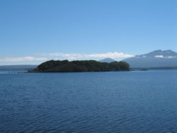
The first settlement at Macquarie Harbour was on Sarah Island, a small island in the harbour. This island was used as a prison for recalcitrant prisoners from other settlements in TasmaniaTasmania
Tasmania is an Australian island and state. It is south of the continent, separated by Bass Strait. The state includes the island of Tasmania—the 26th largest island in the world—and the surrounding islands. The state has a population of 507,626 , of whom almost half reside in the greater Hobart...
, due to its extreme isolation and extreme climate.
Later the small port of Strahan
Strahan, Tasmania
-See also:* Convicts on the West Coast of Tasmania* Macquarie Harbour* Railways on the West Coast of Tasmania* West Coast Piners-Further reading:* *...
was developed on the shores of Macquarie Harbour to support the nearby mining settlements, mainly Queenstown
Queenstown, Tasmania
Queenstown is a town in the West Coast region of the island of Tasmania. It is located in a valley on western slopes of Mount Owen on the West Coast Range.It had a population of 5,119 people . At the 2006 census, Queenstown had a population of 2,117....
. Another port was developed on the south east section of the harbour in Kelly Basin
Kelly Basin, Tasmania
Kelly Basin is a bay on the south eastern side of Macquarie Harbour on the West Coast of Tasmania, Australia.It was the location of the terminus of the North Mount Lyell Railway, and the ghost town of Pillinger....
along with townsite of Pillinger
Pillinger, Tasmania
Pillinger, Tasmania is an abandoned port and townsite in Kelly Basin, on the south eastern side of Macquarie Harbour on the West Coast of Tasmania....
. The settlement and port were short lived as was the North Mount Lyell
North Mount Lyell
North Mount Lyell was the name of a mine, mining company, locality and former railway near Gormanston on the West Coast of Tasmania...
company that developed the facilities.
Named features
- Birchs InletBirchs InletBirchs Inlet, also spelt Birch's Inlet or Birches Inlet, is a narrow cove or coastal inlet on the south-western side of Macquarie Harbour on the west coast of Tasmania, Australia. It is named after Thomas William Birch , a surgeon, whaler, merchant and shipowner who settled in Tasmania in 1808...
- at south west end of harbour - Bird River - mouth in Kelly Basin
- Bonnet Island - in Kelly Channel at entrance to harbour (42° 13′ S, 145° 14′ E}
- Braddon River - mouth on mid-eastern shore
- Entrance Island - at entrance to harbour (42° 12′ S, 145° 14′ E)
- Farm Cove - at south east side
- Gould Point - adjacent to Farm Cove
- Gordon RiverGordon RiverThe Gordon River is one of the major rivers of Tasmania, Australia. It rises in the centre of the island at Lake Richmond and flows westward for about 193km where it empties into Macquarie Harbour on the West Coast of Tasmania. Major tributaries include the Serpentine River and the Franklin...
- mouth on south eastern end of harbour - Hell's GatesHell's Gates (Tasmania)Hells Gates is the name of the mouth of Macquarie Harbour on the West Coast of Tasmania. It is a notoriously shallow and dangerous channel entrance to the harbour. The actual channel is between Cape Sorell, Tasmania on the west and Entrance Island on the east...
- mouth at north west end of harbour - Kelly Basin - port/town at southern end of harbour - also named Pillinger
- Kelly Channel - at entrance to harbour
- King River - mouth at north east of harbour
- Lettes Bay - between Regatta Point and King River mouth
- Liberty Point - on mid western shore
- Long Bay - south of Regatta Point
- Philips Island - adjacent to mouth of Braddon River on east shore
- Pine Cove - just south of the King River Mouth
- Regatta PointRegatta Point, TasmaniaRegatta Point is the location of a port and rail terminus in West Coast Tasmania, Australia- Port :Regatta Point is often assumed into the name of the locality across the bay in Macquarie Harbour, Strahan, Tasmania...
- eastern side of Risby Cove - Risby Cove - water between Strahan Harbour and Regatta Point
- Rum Point - on western shore south of Sarah Island
- Sarah Island - in southern part of Harbour
- Sophia Point - on mid-eastern shore
- Strahan Harbour - from Strahan Point parallel to 'The Esplanade'
- Swan Basin - near Hell's Gates
Tourism
Today Strahan is the base for tourism on the west coast. The West Coast Wilderness RailwayWest Coast Wilderness Railway
The West Coast Wilderness Railway, Tasmania is a reconstruction of the Mount Lyell Mining and Railway Company railway between Queenstown and Regatta Point...
takes part of the north eastern shore of the Harbour, before turning inland at the mouth of the King River.
Boats take tourists to Hell's Gates and Macquarie Heads, Sarah Island and up the lower reaches of the Gordon River. Also charter flights utilise Strahan Airport
Strahan Airport
Strahan Airport is an airport located 3 km west of Strahan, Tasmania, Australia. It is the main airport for the West Coast of Tasmania, and is owned and maintained by the West Coast Council...
for helicopter and fixed wing flights.
Microform
- Kelly, James, 1791-1859. First discovery of Port Davey and Macquarie Harbour p 160-181 "Royal Society of Tasmania: Papers and Proceedings, 1920. Issued separately 24th December, 1920" Microfiche. Canberra : National Library of Australia, 2004.
See also
- Convicts on the West Coast of TasmaniaConvicts on the West Coast of TasmaniaThe West Coast of Tasmania has a significant convict heritage. The use of the West Coast as an outpost to house convicts in isolated penal settlements occurred in the era 1822-1833, and 1846-1847....
- Convictism in AustraliaConvictism in AustraliaDuring the late 18th and 19th centuries, large numbers of convicts were transported to the various Australian penal colonies by the British government. One of the primary reasons for the British settlement of Australia was the establishment of a penal colony to alleviate pressure on their...