
Macarthur, Australian Capital Territory
Encyclopedia
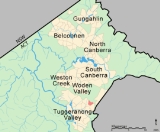
Macarthur is a suburb in the Canberra
district of Tuggeranong. The suburb is named after John Macarthur
, one of the founders of Australia's Merino
wool industry. It was gazetted on 22 March 1982 and first settled in 1983. The wool industry is the theme for street names. The suburb has an area of 1.27 km². It is next to the suburbs of Fadden and Gilmore, and is located north of Isabella Drive.
The residents of Macarthur are predominantly Australian born, with 81.2% being born in Australia. The three main countries of birth for those born overseas were United Kingdom
, 4.6%, New Zealand
1.5, and United States
, 0.7%. The most popular religious affiliations in descending order are Catholic, Anglican
, no religion, Uniting
, Presbyterian and Orthodox Christian
.
, is located in Macarthur. Macarthur also includes a horse holding paddock.
Three ACTION bus routes service Macarthur. Route 67 runs through Macarthur along Coyne Street as part of its route between the Tuggeranong
and Woden
Interchanges; this service runs every 30 to 60 minutes between 6:30 a.m. and 7:30 p.m. on weekdays. The additional service 267 follows the same route through Macarthur as Route 67. It runs during peak hour
from the Tuggeranong Interchange to City West. Another service, route 966 runs between 8:00 a.m. and 11:00pm on Saturdays, 9:00 a.m. and 7:00 p.m. on Sundays and from 7:00 p.m. until 11:00 p.m. on weeknights to link the suburb to Tugggeranong
, Erindale Centre
, Fadden
and Gowrie
when the 67 service does not operate.
Macarthur Park used Coyne Street, Jackie Howe Crescent, Merriman Crescent and Carson Street to form the circuit and the undulating nature of the course made it one of the most attractive road courses in south-east Australia. The Canberra Road Racing Club (formed while racing at Fairburn Park) organised its first race meeting in 1978. Between 1978 and 1982 many race meetings and championship races were run with some modifications to the circuit made to accept sidecars in the last two years of competition.
Now that the suburb has been developed the circuit no longer exists. The only signs are the miscoloured traffic island extension on Coyne Street, which was put back in after the island was shortened to allow sidecars to be raced on the circuit, and a sign in the nearby pines about 50 metres from a small off-street carpark that explains the short history of the circuit and the riders that rode it. Visitors to the area may notice the name of Wayne Gardener on the sign.
of Canberra
. The electorate is currently represented in the House of Representatives
by Annette Ellis
. Canberra is considered a safe Labor
seat.
In the ACT Legislative Assembly
, Gowrie is in the electorate of Brindabella, which is currently represented by three Labor and two Liberal
members.
. This is from the Silurian
age at 414 Mya.
Canberra
Canberra is the capital city of Australia. With a population of over 345,000, it is Australia's largest inland city and the eighth-largest city overall. The city is located at the northern end of the Australian Capital Territory , south-west of Sydney, and north-east of Melbourne...
district of Tuggeranong. The suburb is named after John Macarthur
John MacArthur
John MacArthur may refer to:* John Macarthur , Australian wool industry pioneer and Rum Rebel* John McArthur, Jr. , American architect* John McArthur , Union general during the American Civil War...
, one of the founders of Australia's Merino
Merino
The Merino is an economically influential breed of sheep prized for its wool. Merinos are regarded as having some of the finest and softest wool of any sheep...
wool industry. It was gazetted on 22 March 1982 and first settled in 1983. The wool industry is the theme for street names. The suburb has an area of 1.27 km². It is next to the suburbs of Fadden and Gilmore, and is located north of Isabella Drive.
Demographics
There were 1589 people living in Macarthur on Census night 2001. The median age of people in Macarthur was 32 years, the same as Canberra. Unemployment in Macarthur was two and a half percent lower than the Canberra average. The median weekly individual income for Macarthur in 2001 was $600–$699, compared to $500–$599 for Canberra, while the median weekly household income was $1500–$1999. In 2001 the median monthly housing loan repayment in Macarthur was $800–$999.The residents of Macarthur are predominantly Australian born, with 81.2% being born in Australia. The three main countries of birth for those born overseas were United Kingdom
United Kingdom
The United Kingdom of Great Britain and Northern IrelandIn the United Kingdom and Dependencies, other languages have been officially recognised as legitimate autochthonous languages under the European Charter for Regional or Minority Languages...
, 4.6%, New Zealand
New Zealand
New Zealand is an island country in the south-western Pacific Ocean comprising two main landmasses and numerous smaller islands. The country is situated some east of Australia across the Tasman Sea, and roughly south of the Pacific island nations of New Caledonia, Fiji, and Tonga...
1.5, and United States
United States
The United States of America is a federal constitutional republic comprising fifty states and a federal district...
, 0.7%. The most popular religious affiliations in descending order are Catholic, Anglican
Anglican Church of Australia
The Anglican Church of Australia is a member church of the Anglican Communion. It was previously officially known as the Church of England in Australia and Tasmania...
, no religion, Uniting
Uniting Church in Australia
The Uniting Church in Australia was formed on 22 June 1977 when many congregations of the Methodist Church of Australasia, the Presbyterian Church of Australia and the Congregational Union of Australia came together under the Basis of Union....
, Presbyterian and Orthodox Christian
Eastern Orthodox Church
The Orthodox Church, officially called the Orthodox Catholic Church and commonly referred to as the Eastern Orthodox Church, is the second largest Christian denomination in the world, with an estimated 300 million adherents mainly in the countries of Belarus, Bulgaria, Cyprus, Georgia, Greece,...
.
Suburb amenities
Macarthur Preschool is located on Carson Street; its closure is planned for the end of 2006. Wanniassa Hills, part of the Canberra Nature ParkCanberra Nature Park
The Canberra Nature Park is actually 30 separate protected areas in Canberra, Australian Capital Territory, ranging from bushland hills to lowland native grassland...
, is located in Macarthur. Macarthur also includes a horse holding paddock.
Three ACTION bus routes service Macarthur. Route 67 runs through Macarthur along Coyne Street as part of its route between the Tuggeranong
Tuggeranong Town Centre
Tuggeranong Town Centre services the southernmost Canberra district of Tuggeranong. It is located on the south-western side of Lake Tuggeranong and composed of a large three-storey mall, the Tuggeranong Hyperdome, as well as a smaller shopping complex, the Homeworld, and many other buildings and...
and Woden
Woden Town Centre
Woden Town Centre is the main commercial centre of the district of Woden Valley in Canberra, Australia. It is located in the Canberra suburb of Phillip....
Interchanges; this service runs every 30 to 60 minutes between 6:30 a.m. and 7:30 p.m. on weekdays. The additional service 267 follows the same route through Macarthur as Route 67. It runs during peak hour
Rush hour
A rush hour or peak hour is a part of the day during which traffic congestion on roads and crowding on public transport is at its highest. Normally, this happens twice a day—once in the morning and once in the evening, the times during when the most people commute...
from the Tuggeranong Interchange to City West. Another service, route 966 runs between 8:00 a.m. and 11:00pm on Saturdays, 9:00 a.m. and 7:00 p.m. on Sundays and from 7:00 p.m. until 11:00 p.m. on weeknights to link the suburb to Tugggeranong
Tuggeranong Town Centre
Tuggeranong Town Centre services the southernmost Canberra district of Tuggeranong. It is located on the south-western side of Lake Tuggeranong and composed of a large three-storey mall, the Tuggeranong Hyperdome, as well as a smaller shopping complex, the Homeworld, and many other buildings and...
, Erindale Centre
Erindale Centre
The Erindale Centre is a designated group centre located in the Canberra suburb of Wanniassa. It stands on the former site of the Erindale Homestead for which it is named, and serves the suburbs of Wanniassa, Monash, Gowrie, Fadden and Oxley...
, Fadden
Fadden, Australian Capital Territory
Fadden is a suburb in the Canberra, Australia district of Tuggeranong. The postcode is 2904. The suburb is named after Sir Arthur Fadden, Prime Minister of Australia briefly in 1941. It was gazetted on 5 August 1975. Its streets are named after Queensland politicians...
and Gowrie
Gowrie, Australian Capital Territory
Gowrie is a suburb of Canberra, Australia, located in the northern end of the Tuggeranong Valley. Tuggeranong suburbs are the southernmost of Australia's capital city...
when the 67 service does not operate.
Sport
For a few short years Macarthur was part of the ACT's motorsport activities. In 1978 a group of Canberra motorcycle racers approached the Department of the Interior for permission to use an unbuilt, yet developed, area in one of the unused suburbs in Tuggeranong for racing. The Department gave them permission provided they found a suitable suburb that was well away from built-up areas in the closest suburb, Kambah, and that they complied with noise restrictions of that time. Macarthur, which was being developed but not actively being built upon, was chosen and was thus called Macarthur Park.Macarthur Park used Coyne Street, Jackie Howe Crescent, Merriman Crescent and Carson Street to form the circuit and the undulating nature of the course made it one of the most attractive road courses in south-east Australia. The Canberra Road Racing Club (formed while racing at Fairburn Park) organised its first race meeting in 1978. Between 1978 and 1982 many race meetings and championship races were run with some modifications to the circuit made to accept sidecars in the last two years of competition.
Now that the suburb has been developed the circuit no longer exists. The only signs are the miscoloured traffic island extension on Coyne Street, which was put back in after the island was shortened to allow sidecars to be raced on the circuit, and a sign in the nearby pines about 50 metres from a small off-street carpark that explains the short history of the circuit and the riders that rode it. Visitors to the area may notice the name of Wayne Gardener on the sign.
Politics
Macarthur is located within the federal electorateElectoral district
An electoral district is a distinct territorial subdivision for holding a separate election for one or more seats in a legislative body...
of Canberra
Division of Canberra
The Division of Canberra is an Australian Electoral Division in the Australian Capital Territory. The division was created in 1974 from the southern half of the old Division of Australian Capital Territory...
. The electorate is currently represented in the House of Representatives
Australian House of Representatives
The House of Representatives is one of the two houses of the Parliament of Australia; it is the lower house; the upper house is the Senate. Members of Parliament serve for terms of approximately three years....
by Annette Ellis
Annette Ellis
Annette Louise Ellis , Australian politician, was a Labor Party member of the Australian House of Representatives from March 1996 to August 2010, representing the Division of Namadgi 1996–98 and the Division of Canberra from 1998 to 2010.In the 1996 federal election she contested Namadgi against...
. Canberra is considered a safe Labor
Australian Labor Party
The Australian Labor Party is an Australian political party. It has been the governing party of the Commonwealth of Australia since the 2007 federal election. Julia Gillard is the party's federal parliamentary leader and Prime Minister of Australia...
seat.
In the ACT Legislative Assembly
Australian Capital Territory Legislative Assembly
The Australian Capital Territory Legislative Assembly is the unicameral legislature of the Australian Capital Territory...
, Gowrie is in the electorate of Brindabella, which is currently represented by three Labor and two Liberal
Liberal Party of Australia
The Liberal Party of Australia is an Australian political party.Founded a year after the 1943 federal election to replace the United Australia Party, the centre-right Liberal Party typically competes with the centre-left Australian Labor Party for political office...
members.
Geology
Macarthur is built on Deakin Volcanics green-grey, purple and cream rhyoliteRhyolite
This page is about a volcanic rock. For the ghost town see Rhyolite, Nevada, and for the satellite system, see Rhyolite/Aquacade.Rhyolite is an igneous, volcanic rock, of felsic composition . It may have any texture from glassy to aphanitic to porphyritic...
. This is from the Silurian
Silurian
The Silurian is a geologic period and system that extends from the end of the Ordovician Period, about 443.7 ± 1.5 Mya , to the beginning of the Devonian Period, about 416.0 ± 2.8 Mya . As with other geologic periods, the rock beds that define the period's start and end are well identified, but the...
age at 414 Mya.