
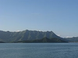
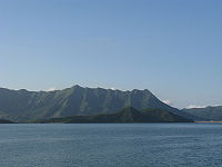
Ma Shi Chau
Encyclopedia
Tai Po District
Tai Po District is one of the 18 districts of Hong Kong. It covers the areas of Tai Po, Tai Po Kau, Ting Kok, Plover Cove and the northern part of Sai Kung Peninsula on both shores of Tolo Channel. It is located in the New Territories...
. It is located in Tolo Harbour
Tolo Harbour
Tolo Harbour , or Tai Po Hoi is a sheltered harbour in northeast New Territories of Hong Kong.-Geography:Tide Cove aka...
in the northeast New Territories
New Territories
New Territories is one of the three main regions of Hong Kong, alongside Hong Kong Island and the Kowloon Peninsula. It makes up 86.2% of Hong Kong's territory. Historically, it is the region described in The Convention for the Extension of Hong Kong Territory...
(near Sam Mun Tsai). It is connected with another island, Yim Tin Tsai
Yim Tin Tsai (Tai Po)
Yim Tin Tsai is an island of Hong Kong located in Tolo Harbour.-Geography:Yim Tin Tsai is located in Tolo Harbour and forms part of the southern border of Plover Cove. It is connected to the mainland in the north by a road, leading next to The Beverly Hills, and to the island of Ma Shi Chau in the...
, by a narrow strip of land that is only accessible when the tide is low.
Geography
Ma Shi Chau has an area of 0.61 km2. It is part of the Ma Shi Chau Special AreaMa Shi Chau Special Area
Ma Shi Chau Special Area is a Special Area of Hong Kong. It is located in Tai Po District and in Tolo Harbour, in the northeast of the New Territories....
, as it exhibits tombolo
Tombolo
A tombolo, from the Italian tombolo, derived from the Latin tumulus, meaning 'mound,' and sometimes translated as ayre , is a deposition landform in which an island is attached to the mainland by a narrow piece of land such as a spit or bar. Once attached, the island is then known as a tied island...
and tide
Tide
Tides are the rise and fall of sea levels caused by the combined effects of the gravitational forces exerted by the moon and the sun and the rotation of the Earth....
features rarely seen in Hong Kong. It is the largest island of the four in the Special Area, the others being Yeung Chau
Yeung Chau, Tai Po
Yeung Chau is an unihabited island of Hong Kong located in Plover Cove, Tolo Harbour, in the northwestern part of the territory. Administratively, it is part of Tai Po District....
, Centre Island
Centre Island, Hong Kong
Centre Island aka. A Chau is a small unihabited island of Hong Kong located in Tolo Harbour, in the northwestern part of the territory. Administratively, it is part of Tai Po District.-History:...
and an unnamed island near Yim Tin Tsai.
It has sedimentary rock
Sedimentary rock
Sedimentary rock are types of rock that are formed by the deposition of material at the Earth's surface and within bodies of water. Sedimentation is the collective name for processes that cause mineral and/or organic particles to settle and accumulate or minerals to precipitate from a solution....
dating back to the Permian
Permian
The PermianThe term "Permian" was introduced into geology in 1841 by Sir Sir R. I. Murchison, president of the Geological Society of London, who identified typical strata in extensive Russian explorations undertaken with Edouard de Verneuil; Murchison asserted in 1841 that he named his "Permian...
period that is protected by its Special Area status.