
.gif)
M-28 Business (Ishpeming-Negaunee, Michigan)
Encyclopedia
M-28 Business Route is a state trunkline highway
serving as a business route
that runs for 4.841 miles (7.791 km) through the downtown districts of Ishpeming
and Negaunee
in Michigan
. The trunkline provides a marked route for traffic diverting from U.S. Highway 41
(US 41) and M-28
through the two historic iron-mining communities. It is one of three business loops for M-numbered highways in the state of Michigan. There have previously been two other BUS M-28 designations for routes in Newberry
and Marquette
.
The trunkline was originally a section of US 41/M-28 and M-35
. Before the 1930s, the main highways ran through the two downtown areas. US 41/M-28 was relocated to run near Teal Lake. The former routing had various names over the years. It was designated as an alternate route
of the main highways, using both the US 41A/M-28A and ALT US 41/ALT M-28 designations before it was designated as BUS M-28 in 1958. M-35 continued to run through downtown Negaunee along a section of the highway until the 1960s. A rerouting in 1999 moved the trunkline designation along Lakeshore Drive in Ishpeming, and a streetscape project rebuilt the road in Negaunee in 2005.
and Niles
for M-32
and M-60
respectively. In the past, two other business routes for M-28 existed in Newberry and Marquette, but they have since been retired. The extant BUS M-28 designation remains for the loop through Ishpeming and Negaunee.
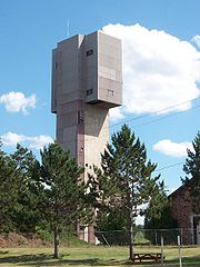
(LS&I) and southeasterly towards Lake Bancroft. South of the lake, BUS M-28 turns east on Division Street. Traffic along the highway here can view the towers of the Cliffs Shaft Mine Museum
; the museum is dedicated to telling the story of underground iron ore mining in the region.
 Division Street carries the BUS M-28 designation into the central business district
of Ishpeming, where it runs past local businesses, Ishpeming High School and the original Ishpeming City Hall
. On the east side of downtown, both the central machine shops and the research labs for Cleveland-Cliffs Iron Company are located on Division Street. Continuing east, the trunkline follows Ready Street over hills and through a residential area to the Ishpeming–Negaunee city line.
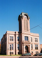 In Negaunee, the routing uses a street named County Road east from the city line. County Road passes Jackson Park, location of the first iron ore discovery in the area. The iron mined from the region supplied half of the nation's supply between 1850 and 1900. South of downtown Negaunee, BUS M-28 turns north along the west fork of Silver Street. The street runs north under an overpass that carries Rail Street, so named because it was once a rail line into downtown Negaunee. The trunkline turns east on Jackson Street, running next to the Negaunee City Hall, which was built in 1914–15 at a time when the city's population was increasing and iron production was peaking. The building still houses the city's offices, police station and library.
The business loop follows Jackson Street east to Division Street, where the street curves slightly and becomes Main Street. BUS M-28 follows Main Street one block to the intersection with Teal Lake Avenue. Turning north, the trunkline follows Teal Lake Avenue through residential areas of town past the Negaunee Middle School and up over a hill. On the opposite side of the hill next to Teal Lake Bluff, the business loop intersects Arch Street, which carries traffic to Negaunee High School to the west or the football field complex to the east. Negaunee High School was the site of the former Mather B Mine Complex. The administration building for the mine was converted to its present educational use in 1986. BUS M-28 continues along Teal Lake Avenue past the football field and under the LS&I tracks where it ends at another signalized intersection with US 41/M-28 by Teal Lake. The total length of BUS M-28 is 4.873 miles (7.842 km).
(MDOT) publishes the annual average daily traffic
(AADT) for its roadways on a yearly basis. AADT is a statistic used in transportation planning
used to express the average number of vehicles on a segment of roadway on any given day of the year. On Lakeshore Drive in Ishpeming, MDOT stated that 6,300 vehicles used the roadway daily in 2006. Along Division Street, traffic drops to 3,700 vehicles before dropping further to 3,300 vehicles along the section on County Road in Negaunee. Silver Street had the lowest traffic counts at 1,700 vehicles on an average day. Traffic is heaviest along Teal Lake Avenue, at 7,800 vehicles.
When M-35 was routed through downtown Negaunee, it joined BUS M-28 northward from the east fork of Silver Street on to US 41/M-28. This routing was moved to bypass the city in 1964 when iron ore mining activity destabilized a portion of the M-35 routing southeast of town. From this point on, BUS M-28 has not shared its routing with any other state trunklines. The western end of BUS M-28 was rerouted on June 4, 1999, when the City of Ishpeming petitioned MDOT to reroute the highway along Lakeshore Drive to US 41/M-28. Previously, it ran along Greenwood Street and North Lake Road and met US 41/M-28 in the West Ishpeming
neighborhood of Ishpeming Township
.
MDOT in a partnership with the City of Negaunee upgraded Teal Lake Avenue between Arch and Rock streets in a streetscaping project to provide a "pedestrian refuge area". This work entailed reconstruction of the retaining wall, curbing and gutters in 2005. Arch Street is the access to Negaunee High School, and this section of BUS M-28 is near the athletic field complex in Negaunee. The project budgeted $120,200 with $24,200 from the City of Negaunee (equivalent to $ and $ respectively in ).
 The following table lists BUS M-28's major intersections with the primary Marquette County Roads.
Michigan Highway System
The Michigan State Trunkline Highway System is made up of all the highways designated as Interstates, U.S. Highways and State Highways in the US state of Michigan. The system is maintained by the Michigan Department of Transportation and comprises of trunklines in all 83 counties of Michigan on...
serving as a business route
Business route
A business route in the United States and Canada is a short special route connected to a parent numbered highway at its beginning, then routed through the central business district of a nearby city or town, and finally reconnecting with the same parent numbered highway again at its...
that runs for 4.841 miles (7.791 km) through the downtown districts of Ishpeming
Ishpeming, Michigan
Ishpeming is a city in Marquette County in the Upper Peninsula of the U.S. state of Michigan. The population was 6,686 at the 2000 census. This is down from a higher population in the 1950s and 1960s when the economically supportive iron ore mines had a much higher employment level...
and Negaunee
Negaunee, Michigan
Negaunee is a city in Marquette County in the U.S. state of Michigan. The population was 4,576 at the 2000 census. The city is located at the southwest corner of Negaunee Township. The city is home to the Michigan Iron Industry Museum...
in Michigan
Michigan
Michigan is a U.S. state located in the Great Lakes Region of the United States of America. The name Michigan is the French form of the Ojibwa word mishigamaa, meaning "large water" or "large lake"....
. The trunkline provides a marked route for traffic diverting from U.S. Highway 41
U.S. Route 41 in Michigan
US Highway 41 is a part of the United States Numbered Highway System that runs from Miami, Florida, to the Upper Peninsula of the US state of Michigan. In Michigan, it is a state trunkline highway that enters the state via the Interstate Bridge between Marinette, Wisconsin, and Menominee,...
(US 41) and M-28
M-28 (Michigan highway)
M-28 is an east–west state trunkline highway that almost completely traverses the Upper Peninsula in the U.S. state of Michigan, from Wakefield to near Sault Ste. Marie in Bruce Township...
through the two historic iron-mining communities. It is one of three business loops for M-numbered highways in the state of Michigan. There have previously been two other BUS M-28 designations for routes in Newberry
Newberry, Michigan
Newberry is a village in the U.S. state of Michigan and the county seat of Luce County. Located within McMillan Township at its very southern end, it shares some administrative responsibilities with the surrounding township. The population was 2,686 at the 2000 census.The village was named in...
and Marquette
Marquette, Michigan
Marquette is a city in the U.S. state of Michigan and the county seat of Marquette County. The population was 21,355 at the 2010 census, making it the most populated city of the Upper Peninsula. Marquette is a major port on Lake Superior, primarily for shipping iron ore and is the home of Northern...
.
The trunkline was originally a section of US 41/M-28 and M-35
M-35 (Michigan highway)
M-35 is a state trunkline highway in the Upper Peninsula of the US state of Michigan. Running for in a general north–south direction, it connects the cities of Menominee, Escanaba and Negaunee. The southern section of M-35 in Menominee and Delta counties carries two additional designations...
. Before the 1930s, the main highways ran through the two downtown areas. US 41/M-28 was relocated to run near Teal Lake. The former routing had various names over the years. It was designated as an alternate route
Alternate route
An official alternate route is a special route in the United States that provides an alternate alignment for a highway. They are loop roads and found in many road systems in the United States including the U.S. Route system and various state route systems...
of the main highways, using both the US 41A/M-28A and ALT US 41/ALT M-28 designations before it was designated as BUS M-28 in 1958. M-35 continued to run through downtown Negaunee along a section of the highway until the 1960s. A rerouting in 1999 moved the trunkline designation along Lakeshore Drive in Ishpeming, and a streetscape project rebuilt the road in Negaunee in 2005.
Route description
There are currently three business routes in the state of Michigan derived from M-numbered highways. The other two are in HillmanHillman, Michigan
Hillman is a village in Alpena and Montmorency counties in the U.S. state of Michigan. The population was 685 at the 2000 census. Nearly all of the village is located within Hillman Township , with only a tiny portion extending into Green Township .-Geography:According to the United States Census...
and Niles
Niles, Michigan
Niles is a city in Berrien and Cass counties in the U.S. state of Michigan, near South Bend, Indiana. The population was 11,600 at the 2010 census. It is the greater populated of two principal cities of and included in the Niles-Benton Harbor, Michigan Metropolitan Statistical Area, which has a...
for M-32
M-32 (Michigan highway)
M-32 is a state trunkline highway in the Lower Peninsula of the U.S. state of Michigan. It is an east–west route running from M-66 in East Jordan to US Highway 23 in Alpena. It runs via Gaylord and Atlanta through forested terrain...
and M-60
M-60 (Michigan highway)
M-60 is an east–west state trunkline highway in the US state of Michigan. It runs from the Niles area at a junction with US Highway 12 to the Jackson area where it ends at Interstate 94 . The trunkline passes through a mix of farm fields and woodlands, crosses or runs along several rivers and...
respectively. In the past, two other business routes for M-28 existed in Newberry and Marquette, but they have since been retired. The extant BUS M-28 designation remains for the loop through Ishpeming and Negaunee.
Ishpeming
BUS M-28 begins at a signalized intersection on US 41/M-28 with Lakeshore Drive in the city of Ishpeming. The trunkline runs south along Lakeshore Drive under the tracks of the Lake Superior and Ishpeming RailroadLake Superior and Ishpeming Railroad
The Lake Superior and Ishpeming Railroad , a U.S. railroad offering service from Marquette, Michigan, to nearby locations in Michigan's Upper Peninsula, began operations in 1896...
(LS&I) and southeasterly towards Lake Bancroft. South of the lake, BUS M-28 turns east on Division Street. Traffic along the highway here can view the towers of the Cliffs Shaft Mine Museum
Cliffs Shaft Mine Museum
The Cliffs Shaft Mine Museum is a former iron mine, now a heritage museum, located on Euclid Street between Lakeshore Drive and Spruce Street in Ishpeming, Michigan. The museum, operated by "Marquette Range Iron Mining Heritage Theme Park Inc.", celebrates the history of the Marquette Iron Range...
; the museum is dedicated to telling the story of underground iron ore mining in the region.
Central business district
A central business district is the commercial and often geographic heart of a city. In North America this part of a city is commonly referred to as "downtown" or "city center"...
of Ishpeming, where it runs past local businesses, Ishpeming High School and the original Ishpeming City Hall
Ishpeming Municipal Building
The Ishpeming Municipal Building is a public building located at 100 East Division Street in Ishpeming, Michigan. It is also known as Ishpeming City Hall...
. On the east side of downtown, both the central machine shops and the research labs for Cleveland-Cliffs Iron Company are located on Division Street. Continuing east, the trunkline follows Ready Street over hills and through a residential area to the Ishpeming–Negaunee city line.
Negaunee
The business loop follows Jackson Street east to Division Street, where the street curves slightly and becomes Main Street. BUS M-28 follows Main Street one block to the intersection with Teal Lake Avenue. Turning north, the trunkline follows Teal Lake Avenue through residential areas of town past the Negaunee Middle School and up over a hill. On the opposite side of the hill next to Teal Lake Bluff, the business loop intersects Arch Street, which carries traffic to Negaunee High School to the west or the football field complex to the east. Negaunee High School was the site of the former Mather B Mine Complex. The administration building for the mine was converted to its present educational use in 1986. BUS M-28 continues along Teal Lake Avenue past the football field and under the LS&I tracks where it ends at another signalized intersection with US 41/M-28 by Teal Lake. The total length of BUS M-28 is 4.873 miles (7.842 km).
Traffic counts
The Michigan Department of TransportationMichigan Department of Transportation
The Michigan Department of Transportation is a constitutional government agency in the US state of Michigan. The primary purpose of MDOT is to maintain the Michigan State Trunkline Highway System which includes all Interstate, US and state highways in Michigan with the exception of the Mackinac...
(MDOT) publishes the annual average daily traffic
Annual average daily traffic
Average Annual daily traffic, abbreviated AADT, is a measure used primarily in transportation planning and transportation engineering. It is the total volume of vehicle traffic of a highway or road for a year divided by 365 days. AADT is a useful and simple measurement of how busy the road is...
(AADT) for its roadways on a yearly basis. AADT is a statistic used in transportation planning
Transportation planning
Transportation planning is a field involved with the evaluation, assessment, design and siting of transportation facilities .-Models and Sustainability :...
used to express the average number of vehicles on a segment of roadway on any given day of the year. On Lakeshore Drive in Ishpeming, MDOT stated that 6,300 vehicles used the roadway daily in 2006. Along Division Street, traffic drops to 3,700 vehicles before dropping further to 3,300 vehicles along the section on County Road in Negaunee. Silver Street had the lowest traffic counts at 1,700 vehicles on an average day. Traffic is heaviest along Teal Lake Avenue, at 7,800 vehicles.
History
BUS M-28 was originally a portion of US 41/M-28 before the construction of the northerly bypass of Ishpeming and Negaunee in 1937. The business loop was not designated BUS M-28 permanently until 1958. It was designated US 41A/M-28A before being redesignated ALT US 41/ALT M-28. This dual designation mirrored the other Marquette County business route, BUS US 41.When M-35 was routed through downtown Negaunee, it joined BUS M-28 northward from the east fork of Silver Street on to US 41/M-28. This routing was moved to bypass the city in 1964 when iron ore mining activity destabilized a portion of the M-35 routing southeast of town. From this point on, BUS M-28 has not shared its routing with any other state trunklines. The western end of BUS M-28 was rerouted on June 4, 1999, when the City of Ishpeming petitioned MDOT to reroute the highway along Lakeshore Drive to US 41/M-28. Previously, it ran along Greenwood Street and North Lake Road and met US 41/M-28 in the West Ishpeming
West Ishpeming, Michigan
West Ishpeming is an unincorporated community in Ishpeming Township, Marquette County in the U.S. state of Michigan. It is also a census-designated place for statistical purposes, with no legal status as an incorporated municipality...
neighborhood of Ishpeming Township
Ishpeming Township, Michigan
Ishpeming Township is a civil township of Marquette County in the U.S. state of Michigan. The population was 3,522 at the 2000 census.- Communities :...
.
MDOT in a partnership with the City of Negaunee upgraded Teal Lake Avenue between Arch and Rock streets in a streetscaping project to provide a "pedestrian refuge area". This work entailed reconstruction of the retaining wall, curbing and gutters in 2005. Arch Street is the access to Negaunee High School, and this section of BUS M-28 is near the athletic field complex in Negaunee. The project budgeted $120,200 with $24,200 from the City of Negaunee (equivalent to $ and $ respectively in ).
Major intersections
See also
- BUS M-28 in NewberryM-28 Business (Newberry, Michigan)M-28 Business Route was a state trunkline highway in the Upper Peninsula of Michigan. It served as a business route running for through the Newberry area. The business loop followed a U-shaped routing to connect downtown Newberry with M-28 south of town...
- BUS US 41 in MarquetteU.S. Route 41 Business (Marquette, Michigan)US Highway 41 Business Route was a state trunkline highway that served as a business loop off US 41 in the US state of Michigan through the City of Marquette along Washington and Front streets. Jurisdiction over the two streets was transferred to the City as part of a route swap that resulted...
, formerly also BUS M-28