

Louth Navigation
Encyclopedia
Louth, Lincolnshire
Louth is a market town and civil parish within the East Lindsey district of Lincolnshire, England.-Geography:Known as the "capital of the Lincolnshire Wolds", it is situated where the ancient trackway Barton Street crosses the River Lud, and has a total resident population of 15,930.The Greenwich...
to Tetney
Tetney
Tetney is a small village in the East Lindsey district of Lincolnshire, England, just west of the Prime Meridian.-Geography and amenities:The village is on the A1031 road, the Cleethorpes-Mablethorpe road, just south of Cleethorpes and Humberston...
in Lincolnshire
Lincolnshire
Lincolnshire is a county in the east of England. It borders Norfolk to the south east, Cambridgeshire to the south, Rutland to the south west, Leicestershire and Nottinghamshire to the west, South Yorkshire to the north west, and the East Riding of Yorkshire to the north. It also borders...
, England
England
England is a country that is part of the United Kingdom. It shares land borders with Scotland to the north and Wales to the west; the Irish Sea is to the north west, the Celtic Sea to the south west, with the North Sea to the east and the English Channel to the south separating it from continental...
, through 8 locks.
Construction
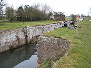
6 of the 8 locks were built in an unusual way with the sides of the lock chambers consisting of 4 elliptical bays, this was apparently to make them stronger. Some of these locks still survive, the remains of one can be seen at AlvinghamAlvingham
Alvingham is a village that lies on a small back road leading east out of Louth, Lincolnshire, England.-Geography:In the west of the parish, it borders Keddington. The parish boundary meets Brackenborough with Little Grimsby, east of Brackenborough Wood. Passing northwards, it meets Yarburgh, and...
. The two other locks had conventional straight walls.
History
The canal obtained its Act of Parliament in 1763 (although the canal had been planned as far back as 1756) and construction started in 1767. The canal opened in 1770. The canal cost £28,000 to build and was able to carry seagoing boats.For much of its life the canal was leased by the Chaplin family who were able to run it at something of a profit with estimated tolls getting as high as £5000 a year in the late 1820s.
The coming of the railways lead to a decline in the use of the canal and World War I
World War I
World War I , which was predominantly called the World War or the Great War from its occurrence until 1939, and the First World War or World War I thereafter, was a major war centred in Europe that began on 28 July 1914 and lasted until 11 November 1918...
killed what traffic was left. The final blow was the devastation caused by the Louth Flood of 1920 to the Riverhead area, the terminus of the canal. The canal closed in 1924.
Louth Navigation Trust
The Louth Navigation Trust have since restored the tow path which may be walked and parts of the canal are in shallow water. They are currently engaged in an ambitious scheme to restore the full length of the canal by 2020.The Louth Navigation, unlike many other disused canals is in water throughout its length and has not been in-filled or built over as it is important for drainage of the surrounding land. Several formerly movable bridges have since been replaced with fixed bridges. The 8 locks are in varying states of repair, two have been completely obliterated, Alvingham lock (pictured) is the best surviving example.