
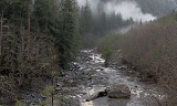
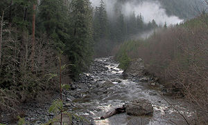
Loss Creek
Encyclopedia

Vancouver Island
Vancouver Island is a large island in British Columbia, Canada. It is one of several North American locations named after George Vancouver, the British Royal Navy officer who explored the Pacific Northwest coast of North America between 1791 and 1794...
, British Columbia, Canada.
The creek runs east-west from north of River Jordan, British Columbia
River Jordan, British Columbia
Jordan River, founded as and still officially gazetteted as River Jordan, is a small settlement on the west coast of Vancouver Island, British Columbia, Canada, located approximately west of Victoria....
to Sombrio Beach. It is geologically interesting since the creek follows the Leech River major thrust fault
Thrust fault
A thrust fault is a type of fault, or break in the Earth's crust across which there has been relative movement, in which rocks of lower stratigraphic position are pushed up and over higher strata. They are often recognized because they place older rocks above younger...
and forms a distinct border between two different terrane
Terrane
A terrane in geology is short-hand term for a tectonostratigraphic terrane, which is a fragment of crustal material formed on, or broken off from, one tectonic plate and accreted or "sutured" to crust lying on another plate...
s: In the south the Crescent Terrane, an ancient volcanic island, and in the north the Pacific Rim Terrane, composed of gneiss
Gneiss
Gneiss is a common and widely distributed type of rock formed by high-grade regional metamorphic processes from pre-existing formations that were originally either igneous or sedimentary rocks.-Etymology:...
and schist
Schist
The schists constitute a group of medium-grade metamorphic rocks, chiefly notable for the preponderance of lamellar minerals such as micas, chlorite, talc, hornblende, graphite, and others. Quartz often occurs in drawn-out grains to such an extent that a particular form called quartz schist is...
.