
Lone Peak Wilderness
Encyclopedia
Uinta National Forest
Uinta National Forest is a national forest located in north central Utah, USA. It was originally part of the Uinta Forest Reserve, created by Grover Cleveland on February 2, 1897. The name is derived from the Ute word Yoov-we-teuh which means pine forest...
and the Wasatch-Cache National Forest
Wasatch-Cache National Forest
Uinta-Wasatch-Cache National Forest is a United States National Forest located primarily in northern Utah , with smaller parts extending into southeastern Idaho and southwestern Wyoming . The name is from the Ute word Wasatch for a low place in high mountains, and the French word Cache meaning to...
in the U.S.
United States
The United States of America is a federal constitutional republic comprising fifty states and a federal district...
state of Utah
Utah
Utah is a state in the Western United States. It was the 45th state to join the Union, on January 4, 1896. Approximately 80% of Utah's 2,763,885 people live along the Wasatch Front, centering on Salt Lake City. This leaves vast expanses of the state nearly uninhabited, making the population the...
.
The Lone Peak Wilderness was established in 1978 as part of the Endangered American Wilderness Act and was the only designated wilderness area in Utah until the enactment of the Utah Wilderness Act of 1984. Situated in the central Wasatch range on the Wasatch-Cache and Uinta National Forests, this wilderness is generally bounded on the north by Little Cottonwood Canyon
Little Cottonwood Canyon
Little Cottonwood Canyon lies within the Wasatch-Cache National Forest along the eastern side of the Salt Lake Valley, roughly 15 miles from Salt Lake City, Utah. The canyon is part of Granite, a CDP and “Community Council” designated by Salt Lake County. The canyon is a glacial trough , carved by...
, on the South by American Fork Canyon
American Fork Canyon
American Fork Canyon is a canyon located in the Wasatch Mountains of Utah. The canyon is famous for the Timpanogos Cave National Monument, which resides on its south side...
, on the west by the Salt Lake
Salt Lake Valley
Salt Lake Valley is a valley in Salt Lake County in the north-central portion of the U.S. state of Utah. It contains Salt Lake City and many of its suburbs, notably West Valley City, Murray, Sandy, and West Jordan; its total population is 1,029,655 as of 2010...
and Utah Valley
Utah Valley
Utah Valley is a valley in North Central Utah located in Utah County, and is considered part of the Wasatch Front. It contains Provo, Orem, and their suburbs, including Highland, Eagle Mountain, Saratoga Springs, Mapleton, Spanish Fork, Lindon, Pleasant Grove, Springville, Lehi, Payson, and...
s, and on the east by Twin Peaks
Twin Peaks
Twin Peaks is an American television serial drama created by David Lynch and Mark Frost. The series follows the investigation headed by FBI Special Agent Dale Cooper , of the murder of a popular teenager and homecoming queen, Laura Palmer...
. Timpanogos Cave National Monument
Timpanogos Cave National Monument
Timpanogos Cave National Monument is a cave system in the Wasatch mountains in American Fork Canyon near American Fork, Utah, in the United States. The 1.5 mile trail to the cave is steep at several points, but paved and wide, so the cave opening is accessible to most...
is adjacent to the south boundary of the Wilderness.
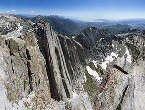
Geology
The Lone Peak Wilderness provides a spectacular backdrop for the growing urban areas along the Wasatch Front and is dominated by rugged terrain, narrow canyons and high peaks, including the PfeifferhornPfeifferhorn
The Pfeifferhorn is the triangularly-shaped peak located in the most isolated part of the Lone Peak Wilderness Area of Utah's Wasatch Mountains. This rugged Utah mountain is commonly referred to as the Little Matterhorn. This summit offers a hiking route to the summit which requires some scrambling...
, commonly referred to as Little Matterhorn
Matterhorn
The Matterhorn , Monte Cervino or Mont Cervin , is a mountain in the Pennine Alps on the border between Switzerland and Italy. Its summit is 4,478 metres high, making it one of the highest peaks in the Alps. The four steep faces, rising above the surrounding glaciers, face the four compass points...
Peak, at 11,326 feet (3,452 m) and Lone Peak
Lone Peak
Lone Peak, a mountain peak southeast of Salt Lake City, Utah, is the center of the Lone Peak Wilderness Area, which was established in 1978. At elevation, it is one of the taller peaks in the Wasatch Range along the Wasatch Front and tends to be a favorite hike...
at 11,253 feet (3,430 meters). The geologic structure of the area is varied and complex, consisting of granitoid
Granitoid
A granitoid or granitic rock is a variety of coarse grained plutonic rock similar to granite which mineralogically are composed predominately of feldspar and quartz. Examples of granitoid rocks include granite, quartz monzonite, quartz diorite, syenite, granodiorite and trondhjemite. Many are...
rock masses and several sedimentary formations. Carving of the present alpine topography is due to glaciation, with erosion being the current dominant force in the land sculpturing process. Much of the higher elevation is alpine, characterized by large, open cirque basins and exposed rocky ridges. A few small natural and reservoired lakes add to the scenic beauty.
Vegetation
Vegetation includes dense mountain brush mixed with sagebrushSagebrush
Sagebrush is a common name of a number of shrubby plant species in the genus Artemisia native to western North America;Or, the sagebrush steppe ecoregion, having one or more kinds of sagebrush, bunchgrasses and others;...
and grass
Grass
Grasses, or more technically graminoids, are monocotyledonous, usually herbaceous plants with narrow leaves growing from the base. They include the "true grasses", of the Poaceae family, as well as the sedges and the rushes . The true grasses include cereals, bamboo and the grasses of lawns ...
. Patches of Douglas fir, subalpine fir
Subalpine Fir
The Subalpine Fir or Rocky Mountain Fir is a western North American fir, native to the mountains of Yukon, British Columbia and western Alberta in Canada; southeastern Alaska, Washington, Oregon, Idaho, western Montana, Wyoming, Utah, Colorado, New Mexico, Arizona, northeastern Nevada, and the...
and aspen
Aspen
Populus section Populus, of the Populus genus, includes the aspen trees and the white poplar Populus alba. The five typical aspens are all native to cold regions with cool summers, in the north of the Northern Hemisphere, extending south at high altitudes in the mountains. The White Poplar, by...
are common in isolated patches on north facing slopes. Snow remains in some areas until mid-summer.
Restrictions
To preserve and protect the physical and aesthetic environment, National ForestUnited States National Forest
National Forest is a classification of federal lands in the United States.National Forests are largely forest and woodland areas owned by the federal government and managed by the United States Forest Service, part of the United States Department of Agriculture. Land management of these areas...
wildernesses are closed to motor vehicles, motorized equipment, hang gliders and bicycles. In addition, parts of this wilderness lay within the culinary watershed for Salt Lake County and special restrictions concerning camping, swimming and domestic animals apply.
The following acts are prohibited in the Lone Peak Wilderness Area:
- Group sizes exceeding 10 persons for overnight use
- Camping within 200 feet (60 m) of lakes, trails, or other sources of water
- Camping for a period of 3 days at an individual site
- Short-cutting a trail switchback, and
- Disposing of garbage, debris, or other waste.
Additionally, open fires are not allowed in the Red Pine Lake, Red Pine Fork and Maybird Gulch drainages within the Wilderness.
Trails
Most trails are rated moderate to severe with elevations from to more than . Trails are easy to follow, but may cross extremely rough terrain at high elevations. Usage of the area is light to moderate, heaviest on weekends and during hunting seasons.Weather
Summer temperatures can range from near 90 °F in the daytime to below 40 °F (4 °C) at night. Occasional summer thundershowers can be expected.See also
- Wilderness ActWilderness ActThe Wilderness Act of 1964 was written by Howard Zahniser of The Wilderness Society. It created the legal definition of wilderness in the United States, and protected some 9 million acres of federal land. The result of a long effort to protect federal wilderness, the Wilderness Act was signed...
- National Wilderness Preservation SystemNational Wilderness Preservation SystemThe National Wilderness Preservation System of the United States protects federally managed land areas designated for preservation in their natural condition. It was established by the Wilderness Act upon the signature of President Lyndon B. Johnson on September 3, 1964...
- List of U.S. Wilderness Areas
External links
- Wilderness.net - Lone Peak Wilderness
- Wasatch-Cache National Forest - Lone Peak Wilderness
- Google Maps satellite view