

Loch Errochty
Encyclopedia
Scottish Highlands
The Highlands is an historic region of Scotland. The area is sometimes referred to as the "Scottish Highlands". It was culturally distinguishable from the Lowlands from the later Middle Ages into the modern period, when Lowland Scots replaced Scottish Gaelic throughout most of the Lowlands...
it is situated within the Perth and Kinross
Perth and Kinross
Perth and Kinross is one of 32 council areas in Scotland, and a Lieutenancy Area. It borders onto the Aberdeenshire, Angus, Dundee City, Fife, Clackmannanshire, Stirling, Argyll and Bute and Highland council areas. Perth is the administrative centre...
council area.
Overview
The Errochty dam lies at the head of Glen Errochty, two km NW of the hamlet of TrinafourTrinafour
Trinafour is a village in Perth and Kinross, Scotland, approximately seventeen miles north-west of Pitlochry, its nearest town. It is located at the western edge of Glen Errochty....
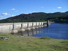
at the approximate grid reference of . The loch has an area of 303 hectares and is 5 km long and a kilometre across at its widest point. The loch is entirely man made, being created by the damming of the Errochty Water, the river which runs down the glen. The dam was constructed in 1957 by the contractors A. & M. Carmichael Ltd as part of phase two of the Tummel hydro-electric power scheme
Tummel hydro-electric power scheme
The Tummel hydro-electric power scheme for the generation of hydro-electric power is located in the Grampian Mountains, between Loch Ericht, Loch Rannoch and Loch Tummel, in Perth and Kinross, Scotland.-References: – PDF file-External links:*...
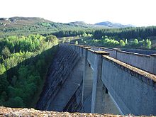
. The loch stands at 330 metres above sea level. The dam itself is an example of a diamond-headed buttress dam
Buttress dam
A buttress dam or hollow dam is a dam with a solid, water-tight upstream side that is supported at intervals on the downstream side by a series of buttresses or supports. The dam wall may be flat or curved. Most buttress dams are made of reinforced concrete and are heavy, pushing the dam into the...
, it is 49 metres high and 354 metres across. The diamond-headed buttresses provide extra strength to deal with possible tremors from the Highland Boundary Fault
Highland Boundary Fault
The Highland Boundary Fault is a geological fault that traverses Scotland from Arran and Helensburgh on the west coast to Stonehaven in the east...
which runs just to the south of Pitlochry
Pitlochry
Pitlochry , is a burgh in the council area of Perth and Kinross, Scotland, lying on the River Tummel. Its population according to the 2001 census was 2,564....
. Water from Loch Errochty is diverted through a 10 km long tunnel to the Errochty hydroelectricity
Hydroelectricity
Hydroelectricity is the term referring to electricity generated by hydropower; the production of electrical power through the use of the gravitational force of falling or flowing water. It is the most widely used form of renewable energy...
power station at the western end of Loch Tummel
Loch Tummel
Loch Tummel is a long, narrow loch, 7 kilometres north west of Pitlochry in Perth and Kinross, Scotland .-Geography:The loch is approximately 11 kilometres long from east to west, and is just under 1 kilometre wide...
. The gatehouse for the tunnel at Loch Errochty is near the southern shore, the actual intake is beneath it at the bottom of the loch. The power station has a maximum output of 75 MW and is the largest power producer of the nine main stations in the Tummel scheme. Water is released from the dam to compensate the flow of the Errochty Water, this compensation water flows down a pipeline for 1.5 km to the very small 500kW hydro power station at Trinafour before being released into the Errochty Water.
Water supply to the loch
Loch Errochty’s main feeder streams are the Allt Sléibh and the Allt Ruighe nan Saorach which both rise in the high ground to the west of the head of the loch. Other small streams flow directly off the 892 metre high mountain of Beinn a' ChuallaichBeinn a' Chuallaich
Beinn a’ Chuallaich is a Scottish hill located at co-ordinates , four km NE of the village of Kinloch Rannoch in the Perth and Kinross council area. It is part of the high ground between Strath Tummel and Glen Errochty.-Overview:...
which stands just to the south. Supplementary water is diverted into the loch from the east by the Errochty catchwater
Catchwater
A catchwater is a large-scale man-made device for catching surface runoff from hills and channelling it to reservoirs for later usage as a part of the public water supply....
, a system of tunnels and surface pipelines at a height of approximately 380 metres which redirects water from five small tributary streams of the River Garry, and the Garry itself. The catchwater then goes through a tunnel in the hill which separates the Garry and Errochty valleys to join the loch. This method of re-directing water allows it to be used more often to generate electricity. Some of the water within the Tummel scheme passes through five of the power stations and thus generates electricity five times.
Access and fishing
The north shore of the loch has a narrow surfaced road which is not open to general traffic, there being a locked gate at Trinafour to prevent access. The south side of the loch has extensive woodlands in the area around the dam wall. A track goes through the woodland from Trinafour and then continues in open country along the south shore until it reaches the ruin of Ruighe nan Saorach. Recreational fishingRecreational fishing
Recreational fishing, also called sport fishing, is fishing for pleasure or competition. It can be contrasted with commercial fishing, which is fishing for profit, or subsistence fishing, which is fishing for survival....
is popular on the loch with some large specimens of Pike
Esox
Esox is a genus of freshwater fish, the only living genus in the family Esocidae — the esocids which were endemic to North America, Europe and Eurasia during the Paleogene through present.The type species is E. lucius, the northern pike...
and Perch
Perch
Perch is a common name for fish of the genus Perca, freshwater gamefish belonging to the family Percidae. The perch, of which there are three species in different geographical areas, lend their name to a large order of vertebrates: the Perciformes, from the Greek perke meaning spotted, and the...
being present. There are no salmon
Salmon
Salmon is the common name for several species of fish in the family Salmonidae. Several other fish in the same family are called trout; the difference is often said to be that salmon migrate and trout are resident, but this distinction does not strictly hold true...
in the loch as a fish ladder
Fish ladder
A fish ladder, also known as a fishway, fish pass or fish steps, is a structure on or around artificial barriers to facilitate diadromous fishes' natural migration. Most fishways enable fish to pass around the barriers by swimming and leaping up a series of relatively low steps into the waters on...
has not been provided to allow the passage of migrating fish past the dam. Permits to fish are required from the Auchleeks estate.
Old buildings
The southern shore of the loch has numerous remains of old buildings, this is believed to be the remnants of old sheep farms which were in the valley before it was flooded. The remains include old farmsteads, shielingShieling
A shieling is a small house or hut once common in the hills and mountains of Scotland and northern England. Farmers and their families lived there during the summer, when their livestock were grazing common land in the hills...
s and sheep pens, some with walls 30 cm (12 ins) high. Many more of the remains are now believed to be under water.