

Little River Canyon Rim Parkway
Encyclopedia
State Route 176 (Alabama)
State Route 176 was created in September 1980 along previous County/Secondary State Roads 81 and 89 in DeKalb County and part of County/Secondary State Road 89 in Cherokee County...
, Dekalb County Road 148 and Cherokee County Road 275, forms a 22-mile scenic drive following the 16-mile long Little River Canyon National Preserve
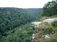
Little River Canyon National Preserve
Little River Canyon National Preserve is a United States National Preserve located on top of Lookout Mountain near Fort Payne, Alabama, and DeSoto State Park. Created by an act of Congress in 1992, the nearly preserve protects what is sometimes said to be the nation's longest mountaintop river,...
in northeastern Alabama
Alabama
Alabama is a state located in the southeastern region of the United States. It is bordered by Tennessee to the north, Georgia to the east, Florida and the Gulf of Mexico to the south, and Mississippi to the west. Alabama ranks 30th in total land area and ranks second in the size of its inland...
. The highway was first designated in 1972 as State Route 275
State Route 275 (Alabama)
State Route 275 is a numbered state highway in Alabama. The route is a western bypass route of Talladega. Commissioned in 1990, State Route 275 is the second incarnation of what was originally the designation for the entire Little River Canyon Rim Parkway.-Route description:SR-275 begins at...
, but was later renumbered to State Route 176 on the northern portion east of former Dekalb County Road 81 and turned back south of former Dekalb County Road 81 in September 1980.
As one of Alabama's most scenic attractions, the highway itself is only well-maintained on the state portion. The turned back portion, which was highly substandard previously, fell into serious disrepair under local control: almost to the point of abandonment. On the small part of the section maintained by Dekalb County
DeKalb County, Alabama
As of the 2010 Census DeKalb County had a population of 71,109. The median age was 37.5. The racial and ethnic makeup of the population was 81.6% non-Hispanic white, 1.5% African American, 1.4% Native American, 0.3% Asian, 0.2% Pacific Islander , 9.9% from some other race, 2.2% reporting two or...
, the road is less than two lanes wide. In Cherokee County
Cherokee County, Alabama
Cherokee County, Alabama is a county of the U.S. state of Alabama. It is named for the Cherokee tribe. As of 2010 the population was 25,989. Its county seat is Centre and it is a prohibition or dry county.- History :...
, the road widens to two narrow lanes, but has miles of broken pavement and potholes. The roadway is also characterized by extremely steep grades both at the Johnnies Creek tributary and where the roadway descends from Lookout Mountain
Lookout Mountain
thumb|right|See seven statesLookout Mountain is located at the northwest corner of the U.S. state of Georgia, the northeast corner of Alabama, and along the southern border of Tennessee at Chattanooga. Lookout Mountain, along with Sand Mountain to the northwest, makes up a large portion of the...
to the Canyon Mouth Park. While the State Route 176 portion has less severe grades, it is designed similarly with sharp curves and a couple sharp drop offs at the edge of the canyon in some areas.
In terms of scenery and attractions, not only does the route cross many seasonal tributaries, but also it has many lookout points, smaller canyons such as Bear Creek, Dees Branch and Johnnies Creek and a view of the state's highest waterfall, Grace's High Falls. Halfway along the route at Eberhardt Point, the highway passes by the site of Canyonland Amusement Park, an abandoned and mostly demolished park that featured a chairlift into the canyon floor. The existence of Canyonland Amusement Park was the likely reason that the original State Route 275 was created. This was especially notable, because a sign for the park (painted over, but with a Coca-Cola logo) was originally placed in an island in the middle of the road entrance on the southern terminus. Another point of interest is the Canyon Mouth Park, where Little River leaves the canyon just before entering Lake Weiss.
While the state portion of the parkway received asphalt for the first time in 2004 (all of the parkway was originally paved with tar and gravel), the county portion continues to go into greater disrepair with no efforts to upgrade, improve or even resurface the route ever commenced. Much improvements in tourist-related signage, overlooks and recreational areas have been made, however, since Little River Canyon became a National Preserve.