

Listed buildings in Barrow-in-Furness
Encyclopedia
There are 272 listed buildings in the Borough of
Barrow-in-Furness
with the majority of these being located in Barrow itself. The following article arranges all buildings by grade (I, II* and II). Approximately 20 of these are concentrated around the ruins of the 12th century Furness Abbey
whilst there are numerous Victorian
buildings in Barrow town centre
along Abbey Road and Duke Street
(including the 19th century Town Hall
).
Barrow-in-Furness (borough)
Barrow-in-Furness is a local government district with borough status in Cumbria, England. It is named after its main town, Barrow-in-Furness. Other settlements include Dalton-in-Furness, Roose and Askam-in-Furness. It is the smallest borough in the county, but is the most densely populated, with...
Barrow-in-Furness
Barrow-in-Furness
Barrow-in-Furness is an industrial town and seaport which forms about half the territory of the wider Borough of Barrow-in-Furness in the county of Cumbria, England. It lies north of Liverpool, northwest of Manchester and southwest from the county town of Carlisle...
with the majority of these being located in Barrow itself. The following article arranges all buildings by grade (I, II* and II). Approximately 20 of these are concentrated around the ruins of the 12th century Furness Abbey
Furness Abbey
Furness Abbey, or St. Mary of Furness is a former monastery situated on the outskirts of the English town of Barrow-in-Furness, Cumbria. The abbey dates back to 1123 and was once the second wealthiest and most powerful Cistercian monastery in the country, behind only Fountains Abbey in North...
whilst there are numerous Victorian
Victorian era
The Victorian era of British history was the period of Queen Victoria's reign from 20 June 1837 until her death on 22 January 1901. It was a long period of peace, prosperity, refined sensibilities and national self-confidence...
buildings in Barrow town centre
Central Barrow
Central Barrow refers to the town centre of Barrow-in-Furness, Cumbria, North West England, UK. Central Barrow is also the name of the electoral ward that covers roughly the Eastern part of Barrow Town Centre. In 2001 5,584 lived in the Central ward, with the majority of people being White...
along Abbey Road and Duke Street
Duke Street, Barrow-in-Furness
Duke Street is a road running through the town centre and Hindpool area of Barrow-in-Furness, England. Stretching almost one mile from east to west it connects two major A roads as well as intersecting Abbey Road roughly midway...
(including the 19th century Town Hall
Barrow-in-Furness Town Hall
Barrow-in-Furness Town Hall is a Victorian-era, neo-gothic municipal building in Barrow-in-Furness, England. The building serves as the base of Barrow Borough Council and houses a number of local government departments. The building was constructed in a four year period entirely from local sandstone...
).
Grade I Listed buildings
The town of Barrow and its immediate surrounding area has 8 Grade I listed buildings. They are listed below.| Name | Image | Location | Year Comleted | Year Listed | English Heritage Description |
|---|---|---|---|---|---|
| Piel Castle Piel Castle Piel Castle also known as Fouldry Castle, is a castle situated on the south-eastern point of Piel Island, 1 km off the southern tip of the Furness Peninsula, protecting the deep water harbour of Barrow-in-Furness in north west England..... |
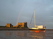 |
Roose Roose Roose or Roosecote is a suburb and ward of Barrow-in-Furness, Cumbria, England. The word 'roose' is Celtic for "moor" or "heath" and the suffix 'cote' of Roosecote means "hut" or "huts"... (Piel Island Piel Island Piel Island lies half a mile off the southern tip of the Furness Peninsula in the administrative county of Cumbria, though historically within Lancashire north of the sands. It is located at . It is one of the Islands of Furness in Northern England... ) |
1327 | 1949 | PIEL CASTLE |
| Furness Abbey Furness Abbey Furness Abbey, or St. Mary of Furness is a former monastery situated on the outskirts of the English town of Barrow-in-Furness, Cumbria. The abbey dates back to 1123 and was once the second wealthiest and most powerful Cistercian monastery in the country, behind only Fountains Abbey in North... |
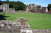 |
Newbarns Newbarns Newbarns is an area and electoral ward of Barrow-in-Furness, Cumbria, England. It is bordered by Hawcoat, Parkside, Risedale and Roose, the local population stood at 5,515 in 2001. Newbarns covers an area of 2.78 square kilometres and lies east of Abbey Road, and encompases Furness Abbey, Barrow... |
1127 | 1949 | FURNESS ABBEY, INCLUDING ALL MEDIEVAL REMAINS IN CARE OF ENGLISH HERITAGE |
| Furness Abbey Chapel Furness Abbey Furness Abbey, or St. Mary of Furness is a former monastery situated on the outskirts of the English town of Barrow-in-Furness, Cumbria. The abbey dates back to 1123 and was once the second wealthiest and most powerful Cistercian monastery in the country, behind only Fountains Abbey in North... |
Newbarns Newbarns Newbarns is an area and electoral ward of Barrow-in-Furness, Cumbria, England. It is bordered by Hawcoat, Parkside, Risedale and Roose, the local population stood at 5,515 in 2001. Newbarns covers an area of 2.78 square kilometres and lies east of Abbey Road, and encompases Furness Abbey, Barrow... |
c.1300 | 1976 | CAPELLA EXTRA PORTAS WITH ATTACHED WALLS | |
| Furness Abbey Main Gateway Furness Abbey Furness Abbey, or St. Mary of Furness is a former monastery situated on the outskirts of the English town of Barrow-in-Furness, Cumbria. The abbey dates back to 1123 and was once the second wealthiest and most powerful Cistercian monastery in the country, behind only Fountains Abbey in North... |
Newbarns Newbarns Newbarns is an area and electoral ward of Barrow-in-Furness, Cumbria, England. It is bordered by Hawcoat, Parkside, Risedale and Roose, the local population stood at 5,515 in 2001. Newbarns covers an area of 2.78 square kilometres and lies east of Abbey Road, and encompases Furness Abbey, Barrow... |
c.1500s | 1976 | GATEWAY ADJOINING CAPELLA EXTRA | |
| Furness Abbey Precinct Wall Furness Abbey Furness Abbey, or St. Mary of Furness is a former monastery situated on the outskirts of the English town of Barrow-in-Furness, Cumbria. The abbey dates back to 1123 and was once the second wealthiest and most powerful Cistercian monastery in the country, behind only Fountains Abbey in North... |
Newbarns Newbarns Newbarns is an area and electoral ward of Barrow-in-Furness, Cumbria, England. It is bordered by Hawcoat, Parkside, Risedale and Roose, the local population stood at 5,515 in 2001. Newbarns covers an area of 2.78 square kilometres and lies east of Abbey Road, and encompases Furness Abbey, Barrow... |
1127 | 1949 | FURNESS ABBEY WALL | |
| Furness Abbey West Gateway Furness Abbey Furness Abbey, or St. Mary of Furness is a former monastery situated on the outskirts of the English town of Barrow-in-Furness, Cumbria. The abbey dates back to 1123 and was once the second wealthiest and most powerful Cistercian monastery in the country, behind only Fountains Abbey in North... |
Newbarns Newbarns Newbarns is an area and electoral ward of Barrow-in-Furness, Cumbria, England. It is bordered by Hawcoat, Parkside, Risedale and Roose, the local population stood at 5,515 in 2001. Newbarns covers an area of 2.78 square kilometres and lies east of Abbey Road, and encompases Furness Abbey, Barrow... |
c.1300s | 1976 | ST GATE TO FURNESS ABBEY, REMAINS OF | |
| Rampside Hall | Roose Roose Roose or Roosecote is a suburb and ward of Barrow-in-Furness, Cumbria, England. The word 'roose' is Celtic for "moor" or "heath" and the suffix 'cote' of Roosecote means "hut" or "huts"... (Rampside Rampside Rampside is a village in Cumbria, England, located a few miles south-east of the town of Barrow-in-Furness, in the north-western corner of Morecambe Bay on the Furness peninsula.-History:... ) |
c.1600s | 1949 | RAMPSIDE HALL 101 |
Grade II* Listed buildings
The town of Barrow and it's immediate surrounding area has 15 Grade II* listed buildings. They are listed below.| Name | Image | Location | Year Comleted | Year Listed | English Heritage Description |
|---|---|---|---|---|---|
| Abbey House Hotel Abbey House, Barrow-in-Furness Abbey House, Barrow-in-Furness in the modern county of Cumbria, formerly in Lancashire , is a Neo-Elizabethan H-plan mansion built by Sir Edwin Lutyens in 1913-14 as a guest house for Vickers Ltd and a flat for the Managing Director, Sir James McKechnie. In its abstracted, military echo of the... |
Newbarns Newbarns Newbarns is an area and electoral ward of Barrow-in-Furness, Cumbria, England. It is bordered by Hawcoat, Parkside, Risedale and Roose, the local population stood at 5,515 in 2001. Newbarns covers an area of 2.78 square kilometres and lies east of Abbey Road, and encompases Furness Abbey, Barrow... |
1914 | 1949 | ABBEY HOUSE HOTEL | |
| Sowerby Hall Farm, Barn | Ormsgill Ormsgill Ormsgill is a ward of Barrow-in-Furness, Cumbria, England. It is bordered by Hindpool, Parkside, Hawcoat, Roanhead and the Walney Channel. The population of the ward in 2001 stood at 5,961... |
c.1500s | 1993 | BARN IMMEDIATELY TO REAR OF SOWERBY HALL FARMHOUSE | |
| St. James' Church St. James' Church, Barrow-in-Furness St. James' Church is a large Church of England church in Barrow-in-Furness, England. It belongs to the Diocese of Carlisle which in itself forms part of the ecclesiastical Province of York. St... |
Hindpool Hindpool Hindpool is an area and electoral ward of Barrow-in-Furness, Cumbria, England. It is bordered by Barrow Island, Central Barrow, Ormsgill, Parkside and the Walney Channel, the local population stood at 5,515 in 2001. The ward covers the entire western half of the town centre and includes Barrow's... |
1869 | 1976 | CHURCH OF ST JAMES | |
| Barrow-in-Furness Town Hall Barrow-in-Furness Town Hall Barrow-in-Furness Town Hall is a Victorian-era, neo-gothic municipal building in Barrow-in-Furness, England. The building serves as the base of Barrow Borough Council and houses a number of local government departments. The building was constructed in a four year period entirely from local sandstone... |
Central Barrow Central Barrow Central Barrow refers to the town centre of Barrow-in-Furness, Cumbria, North West England, UK. Central Barrow is also the name of the electoral ward that covers roughly the Eastern part of Barrow Town Centre. In 2001 5,584 lived in the Central ward, with the majority of people being White... |
1887 | 1976 | TOWN HALL | |
| Devonshire Pub | Barrow Island | 1874 | 1976 | THE DEVONSHIRE PUBLIC HOUSE | |
| Devonshire Buildings | Barrow Island | 1875 | 1976 | DEVONSHIRE BUILDINGS 10-14 | |
| Ormsgill Farmhouse | Ormsgill Ormsgill Ormsgill is a ward of Barrow-in-Furness, Cumbria, England. It is bordered by Hindpool, Parkside, Hawcoat, Roanhead and the Walney Channel. The population of the ward in 2001 stood at 5,961... |
1605 | 1949 | ORMSGILL FARMHOUSE | |
| Park House Farmhouse | Newbarns Newbarns Newbarns is an area and electoral ward of Barrow-in-Furness, Cumbria, England. It is bordered by Hawcoat, Parkside, Risedale and Roose, the local population stood at 5,515 in 2001. Newbarns covers an area of 2.78 square kilometres and lies east of Abbey Road, and encompases Furness Abbey, Barrow... |
c.1500s | 1949 | PARK HOUSE FARMHOUSE | |
| 1-13 Sloop Street | Barrow Island | 1884 | 1993 | SLOOP STREET TENEMENTS | |
| Walney Lighthouse | South Walney Walney Island The Isle of Walney, also known as Walney Island, is an island in the United Kingdom which lies off the west coast of England, at the northern tip of Morecambe Bay. It forms part of the Borough of Barrow-in-Furness, and it is separated from the mainland at Barrow by Walney Channel, a narrow channel... |
1790 | 1976 | WALNEY LIGHTHOUSE WITH TWO ATTACHED COTTAGES AND OUTBUILDINGS | |
| 1-13 Steamer Street | Barrow Island | 1884 | 1993 | STEAMER STREET TENEMENTS |
Grade II Listed buildings
The town of Barrow and it's immediate surrounding area has 249 Grade II listed buildings. They are listed below.| Name | Image | Location | Year Comleted | Year Listed | English Heritage Description |
|---|---|---|---|---|---|
| 1-8 Piel Island | Roose Roose Roose or Roosecote is a suburb and ward of Barrow-in-Furness, Cumbria, England. The word 'roose' is Celtic for "moor" or "heath" and the suffix 'cote' of Roosecote means "hut" or "huts"... (Piel Island Piel Island Piel Island lies half a mile off the southern tip of the Furness Peninsula in the administrative county of Cumbria, though historically within Lancashire north of the sands. It is located at . It is one of the Islands of Furness in Northern England... ) |
1875 | 1976 | 1-8 PIEL ISLAND | |
| The Ship Inn | Roose Roose Roose or Roosecote is a suburb and ward of Barrow-in-Furness, Cumbria, England. The word 'roose' is Celtic for "moor" or "heath" and the suffix 'cote' of Roosecote means "hut" or "huts"... (Piel Island Piel Island Piel Island lies half a mile off the southern tip of the Furness Peninsula in the administrative county of Cumbria, though historically within Lancashire north of the sands. It is located at . It is one of the Islands of Furness in Northern England... ) |
c.1700s | 1976 | THE SHIP INN | |
| Roa Island Hotel | Roose Roose Roose or Roosecote is a suburb and ward of Barrow-in-Furness, Cumbria, England. The word 'roose' is Celtic for "moor" or "heath" and the suffix 'cote' of Roosecote means "hut" or "huts"... (Roa Island Roa Island Roa Island lies just over half a mile south of the village of Rampside at the southernmost point of the Furness Peninsula in Cumbria, though formerly in the area of Lancashire north of the sands. It is located at . It is one of the Islands of Furness in northern England. It has an area of about... ) |
c.1800s | 1976 | ROA ISLAND HOTEL | |
| Glenfield House, Former Mining Offices | Roose Roose Roose or Roosecote is a suburb and ward of Barrow-in-Furness, Cumbria, England. The word 'roose' is Celtic for "moor" or "heath" and the suffix 'cote' of Roosecote means "hut" or "huts"... (Stank) |
1875 | 1976 | GLENFIELD HOUSE | |
| Stank Iron ore Mines Entrance | Roose Roose Roose or Roosecote is a suburb and ward of Barrow-in-Furness, Cumbria, England. The word 'roose' is Celtic for "moor" or "heath" and the suffix 'cote' of Roosecote means "hut" or "huts"... (Stank) |
1875 | 1976 | ENTRANCE GATEWAYS TO GLENFIELD HOUSE INCLUDING ATTACHED SIDE GATE TO ROSE COTTAGE | |
| Stank Mines Engine House | Roose Roose Roose or Roosecote is a suburb and ward of Barrow-in-Furness, Cumbria, England. The word 'roose' is Celtic for "moor" or "heath" and the suffix 'cote' of Roosecote means "hut" or "huts"... (Stank) |
1875 | 1976 | ENGINE HOUSE AT NGR SD 2325 7080 TO NORTH EAST OF GLENFIELD HOUSE | |
| Former Mine Ancillary Block | Roose Roose Roose or Roosecote is a suburb and ward of Barrow-in-Furness, Cumbria, England. The word 'roose' is Celtic for "moor" or "heath" and the suffix 'cote' of Roosecote means "hut" or "huts"... (Stank) |
1875 | 1976 | FORMER MINE BUILDING IMMEDIATELY TO NORTH OF GLENFIELD HOUSE | |
| Rose Cottage, Former Mine Lodge | Roose Roose Roose or Roosecote is a suburb and ward of Barrow-in-Furness, Cumbria, England. The word 'roose' is Celtic for "moor" or "heath" and the suffix 'cote' of Roosecote means "hut" or "huts"... (Stank) |
1875 | 1976 | ROSE COTTAGE | |
| Stank Farm | Roose Roose Roose or Roosecote is a suburb and ward of Barrow-in-Furness, Cumbria, England. The word 'roose' is Celtic for "moor" or "heath" and the suffix 'cote' of Roosecote means "hut" or "huts"... (Stank) |
c.1600s | 1976 | STANK FARMHOUSE AND ATTACHED FARM BUILDINGS | |
| Stank Farm Cow House | Roose Roose Roose or Roosecote is a suburb and ward of Barrow-in-Furness, Cumbria, England. The word 'roose' is Celtic for "moor" or "heath" and the suffix 'cote' of Roosecote means "hut" or "huts"... (Stank) |
c.1700s | 1976 | BARN ON ROADSIDE TO NORTH WEST OF STANK FARMHOUSE | |
| Porter's Lodge | Newbarns Newbarns Newbarns is an area and electoral ward of Barrow-in-Furness, Cumbria, England. It is bordered by Hawcoat, Parkside, Risedale and Roose, the local population stood at 5,515 in 2001. Newbarns covers an area of 2.78 square kilometres and lies east of Abbey Road, and encompases Furness Abbey, Barrow... |
1873 | 1976 | ABBEY DALE | |
| Bow Bridge Bow Bridge, Cumbria Bow Bridge is a late medieval bridge located near Furness Abbey in Cumbria. It is made of stone and crosses Mill Beck. It has been a Grade II Listed Structure since 1993.... |
Newbarns Newbarns Newbarns is an area and electoral ward of Barrow-in-Furness, Cumbria, England. It is bordered by Hawcoat, Parkside, Risedale and Roose, the local population stood at 5,515 in 2001. Newbarns covers an area of 2.78 square kilometres and lies east of Abbey Road, and encompases Furness Abbey, Barrow... |
1873 | 1993 | BRIDGE OVER MILL BECK AND ATTACHED GATEWAY AT ABBEY DALE | |
| Furness Abbey Cottage | Newbarns Newbarns Newbarns is an area and electoral ward of Barrow-in-Furness, Cumbria, England. It is bordered by Hawcoat, Parkside, Risedale and Roose, the local population stood at 5,515 in 2001. Newbarns covers an area of 2.78 square kilometres and lies east of Abbey Road, and encompases Furness Abbey, Barrow... |
1873 | 1983 | FURNESS ABBEY COTTAGE | |
| Former Custodian's Cottage | Newbarns Newbarns Newbarns is an area and electoral ward of Barrow-in-Furness, Cumbria, England. It is bordered by Hawcoat, Parkside, Risedale and Roose, the local population stood at 5,515 in 2001. Newbarns covers an area of 2.78 square kilometres and lies east of Abbey Road, and encompases Furness Abbey, Barrow... |
c.1400s | 1993 | FURNESS ABBEY, FORMER CUSTODIAN'S COTTAGE | |
| The Abbey Tavern | Newbarns Newbarns Newbarns is an area and electoral ward of Barrow-in-Furness, Cumbria, England. It is bordered by Hawcoat, Parkside, Risedale and Roose, the local population stood at 5,515 in 2001. Newbarns covers an area of 2.78 square kilometres and lies east of Abbey Road, and encompases Furness Abbey, Barrow... |
c.1800s | 1993 | THE ABBEY TAVERN | |
| 298 Abbey Road Abbey Road (Barrow) Abbey Road is the principal road system through the English town of Barrow-in-Furness, its name derives from Furness Abbey which lies at the northern end of the road. Barrow is one of the few planned towns in the UK and Abbey Road was built as the main highway through it... |
Newbarns Newbarns Newbarns is an area and electoral ward of Barrow-in-Furness, Cumbria, England. It is bordered by Hawcoat, Parkside, Risedale and Roose, the local population stood at 5,515 in 2001. Newbarns covers an area of 2.78 square kilometres and lies east of Abbey Road, and encompases Furness Abbey, Barrow... |
1878 | 1976 | 298 ABBEY ROAD | |
| Abbey Gate Cottages | Newbarns Newbarns Newbarns is an area and electoral ward of Barrow-in-Furness, Cumbria, England. It is bordered by Hawcoat, Parkside, Risedale and Roose, the local population stood at 5,515 in 2001. Newbarns covers an area of 2.78 square kilometres and lies east of Abbey Road, and encompases Furness Abbey, Barrow... |
1873 | 1976 | ABBEY GATE COTTAGES | |
| North Lodge, Abbey House Abbey House, Barrow-in-Furness Abbey House, Barrow-in-Furness in the modern county of Cumbria, formerly in Lancashire , is a Neo-Elizabethan H-plan mansion built by Sir Edwin Lutyens in 1913-14 as a guest house for Vickers Ltd and a flat for the Managing Director, Sir James McKechnie. In its abstracted, military echo of the... |
Newbarns Newbarns Newbarns is an area and electoral ward of Barrow-in-Furness, Cumbria, England. It is bordered by Hawcoat, Parkside, Risedale and Roose, the local population stood at 5,515 in 2001. Newbarns covers an area of 2.78 square kilometres and lies east of Abbey Road, and encompases Furness Abbey, Barrow... |
1914 | 1976 | NORTH LODGE TO ABBEY HOUSE | |
| West Lodge, Abbey House Abbey House, Barrow-in-Furness Abbey House, Barrow-in-Furness in the modern county of Cumbria, formerly in Lancashire , is a Neo-Elizabethan H-plan mansion built by Sir Edwin Lutyens in 1913-14 as a guest house for Vickers Ltd and a flat for the Managing Director, Sir James McKechnie. In its abstracted, military echo of the... |
Newbarns Newbarns Newbarns is an area and electoral ward of Barrow-in-Furness, Cumbria, England. It is bordered by Hawcoat, Parkside, Risedale and Roose, the local population stood at 5,515 in 2001. Newbarns covers an area of 2.78 square kilometres and lies east of Abbey Road, and encompases Furness Abbey, Barrow... |
1914 | 1976 | WEST LODGE TO ABBEY HOUSE WITH ATTACHED GATEHOUSE AND WING WALLS | |
| Central Fire Station | Central Barrow Central Barrow Central Barrow refers to the town centre of Barrow-in-Furness, Cumbria, North West England, UK. Central Barrow is also the name of the electoral ward that covers roughly the Eastern part of Barrow Town Centre. In 2001 5,584 lived in the Central ward, with the majority of people being White... |
1911 | 1991 | CENTRAL FIRE STATION | |
| Nan Tait Centre Nan Tait Centre The Nan Tait Centre is a Grade II listed building located on Abbey Road in the Hindpool area of Barrow-in-Furness, Cumbria, England. Designed by architects Woodhouse and Willoughby it was built for the Barrow Corporation as the town's new Technical School. The foundation stone was laid on 26 May... |
Hindpool Hindpool Hindpool is an area and electoral ward of Barrow-in-Furness, Cumbria, England. It is bordered by Barrow Island, Central Barrow, Ormsgill, Parkside and the Walney Channel, the local population stood at 5,515 in 2001. The ward covers the entire western half of the town centre and includes Barrow's... |
1903 | 1976 | COLLEGE OF FURTHER EDUCATION ANNEXE INCLUDING FRONT RAILINGS AND PIERS | |
| Abbey Road Conservatives Club | Hindpool Hindpool Hindpool is an area and electoral ward of Barrow-in-Furness, Cumbria, England. It is bordered by Barrow Island, Central Barrow, Ormsgill, Parkside and the Walney Channel, the local population stood at 5,515 in 2001. The ward covers the entire western half of the town centre and includes Barrow's... |
1899 | 1976 | CONSERVATIVE CLUB | |
| Cooke's Buildings | Hindpool Hindpool Hindpool is an area and electoral ward of Barrow-in-Furness, Cumbria, England. It is bordered by Barrow Island, Central Barrow, Ormsgill, Parkside and the Walney Channel, the local population stood at 5,515 in 2001. The ward covers the entire western half of the town centre and includes Barrow's... |
1875 | 1976 | COOKE'S BUILDINGS | |
| Duke of Edinburgh Hotel The Duke of Edinburgh Hotel The Duke of Edinburgh Hotel is a 4-star luxury hotel located on Abbey Road in Barrow-in-Furness, England. The building itself was built in 1871 and was granted grade II status in 1976. The hotel was built during a period of great economic growth in Barrow, the town was home to the largest... |
Hindpool Hindpool Hindpool is an area and electoral ward of Barrow-in-Furness, Cumbria, England. It is bordered by Barrow Island, Central Barrow, Ormsgill, Parkside and the Walney Channel, the local population stood at 5,515 in 2001. The ward covers the entire western half of the town centre and includes Barrow's... |
1875 | 1976 | DUKE OF EDINBURGH HOTEL | |
| Abbey Approach Gateway | Newbarns Newbarns Newbarns is an area and electoral ward of Barrow-in-Furness, Cumbria, England. It is bordered by Hawcoat, Parkside, Risedale and Roose, the local population stood at 5,515 in 2001. Newbarns covers an area of 2.78 square kilometres and lies east of Abbey Road, and encompases Furness Abbey, Barrow... |
1873 | 1976 | GATEWAY TO ABBEY APPROACH | |
| Dane Gill Beck Bridge | Newbarns Newbarns Newbarns is an area and electoral ward of Barrow-in-Furness, Cumbria, England. It is bordered by Hawcoat, Parkside, Risedale and Roose, the local population stood at 5,515 in 2001. Newbarns covers an area of 2.78 square kilometres and lies east of Abbey Road, and encompases Furness Abbey, Barrow... |
1887 | 1993 | JUBILEE BRIDGE | |
| Oxford Chambers | Hindpool Hindpool Hindpool is an area and electoral ward of Barrow-in-Furness, Cumbria, England. It is bordered by Barrow Island, Central Barrow, Ormsgill, Parkside and the Walney Channel, the local population stood at 5,515 in 2001. The ward covers the entire western half of the town centre and includes Barrow's... |
1875 | 1976 | OXFORD CHAMBERS | |
| Public Library Telephone Booths | Hindpool Hindpool Hindpool is an area and electoral ward of Barrow-in-Furness, Cumbria, England. It is bordered by Barrow Island, Central Barrow, Ormsgill, Parkside and the Walney Channel, the local population stood at 5,515 in 2001. The ward covers the entire western half of the town centre and includes Barrow's... |
1935 | 1987 | PAIR OF K6 TELEPHONE KIOSKS ADJACENT TO PUBLIC LIBRARY | |
| Ramsden Hall | Hindpool Hindpool Hindpool is an area and electoral ward of Barrow-in-Furness, Cumbria, England. It is bordered by Barrow Island, Central Barrow, Ormsgill, Parkside and the Walney Channel, the local population stood at 5,515 in 2001. The ward covers the entire western half of the town centre and includes Barrow's... |
1872 | 1976 | RAMSDEN HALL | |
| Abbey Road Working Men's Club | Hindpool Hindpool Hindpool is an area and electoral ward of Barrow-in-Furness, Cumbria, England. It is bordered by Barrow Island, Central Barrow, Ormsgill, Parkside and the Walney Channel, the local population stood at 5,515 in 2001. The ward covers the entire western half of the town centre and includes Barrow's... |
1871 | 1976 | WORKING MEN'S CLUB AND INSTITUTE | |
| Sowerby Hall Farmhouse | Ormsgill Ormsgill Ormsgill is a ward of Barrow-in-Furness, Cumbria, England. It is bordered by Hindpool, Parkside, Hawcoat, Roanhead and the Walney Channel. The population of the ward in 2001 stood at 5,961... |
1880 | 1976 | SOWERBY HALL FARMHOUSE | |
| Sowerby Lodge | Ormsgill Ormsgill Ormsgill is a ward of Barrow-in-Furness, Cumbria, England. It is bordered by Hindpool, Parkside, Hawcoat, Roanhead and the Walney Channel. The population of the ward in 2001 stood at 5,961... |
c.1600s | 1976 | SOWERBY LODGE FARMHOUSE | |
| Sowerby Lodge Barn | Ormsgill Ormsgill Ormsgill is a ward of Barrow-in-Furness, Cumbria, England. It is bordered by Hindpool, Parkside, Hawcoat, Roanhead and the Walney Channel. The population of the ward in 2001 stood at 5,961... |
c.1700s | 1976 | BARN IMMEDIATELY TO NORTH EAST OF SOWERBY LODGE FARMHOUSE | |
| 1-9 Barque Street | Ormsgill Ormsgill Ormsgill is a ward of Barrow-in-Furness, Cumbria, England. It is bordered by Hindpool, Parkside, Hawcoat, Roanhead and the Walney Channel. The population of the ward in 2001 stood at 5,961... |
1884 | 1993 | BARQUE STREET TENEMENTS 1-9 | |
| 2 Biggar Village, Farm Buildings | South Walney Walney Island The Isle of Walney, also known as Walney Island, is an island in the United Kingdom which lies off the west coast of England, at the northern tip of Morecambe Bay. It forms part of the Borough of Barrow-in-Furness, and it is separated from the mainland at Barrow by Walney Channel, a narrow channel... (Biggar Biggar, Cumbria Biggar is a village towards the south of Walney Island in Cumbria, England. Along with the village of North Scale, it is the oldest settlement on the island. It now forms part of the Borough of Barrow-in-Furness.... ) |
c.1600s | 1976 | RANGE OF FARM BUILDINGS ATTACHED TO NUMBER 2 | |
| 6 Biggar Village | South Walney Walney Island The Isle of Walney, also known as Walney Island, is an island in the United Kingdom which lies off the west coast of England, at the northern tip of Morecambe Bay. It forms part of the Borough of Barrow-in-Furness, and it is separated from the mainland at Barrow by Walney Channel, a narrow channel... (Biggar Biggar, Cumbria Biggar is a village towards the south of Walney Island in Cumbria, England. Along with the village of North Scale, it is the oldest settlement on the island. It now forms part of the Borough of Barrow-in-Furness.... ) |
c.1700s | 1976 | MANOR FARMHOUSE 6 | |
| 8 Biggar Village | South Walney Walney Island The Isle of Walney, also known as Walney Island, is an island in the United Kingdom which lies off the west coast of England, at the northern tip of Morecambe Bay. It forms part of the Borough of Barrow-in-Furness, and it is separated from the mainland at Barrow by Walney Channel, a narrow channel... (Biggar Biggar, Cumbria Biggar is a village towards the south of Walney Island in Cumbria, England. Along with the village of North Scale, it is the oldest settlement on the island. It now forms part of the Borough of Barrow-in-Furness.... ) |
c.1700s | 1976 | SQUIRE'S COTTAGE 8 | |
| 10 Biggar Village | South Walney Walney Island The Isle of Walney, also known as Walney Island, is an island in the United Kingdom which lies off the west coast of England, at the northern tip of Morecambe Bay. It forms part of the Borough of Barrow-in-Furness, and it is separated from the mainland at Barrow by Walney Channel, a narrow channel... (Biggar Biggar, Cumbria Biggar is a village towards the south of Walney Island in Cumbria, England. Along with the village of North Scale, it is the oldest settlement on the island. It now forms part of the Borough of Barrow-in-Furness.... ) |
c.1800s | 1976 | RAINBOW COTTAGE 10 | |
| 12 Biggar Village | South Walney Walney Island The Isle of Walney, also known as Walney Island, is an island in the United Kingdom which lies off the west coast of England, at the northern tip of Morecambe Bay. It forms part of the Borough of Barrow-in-Furness, and it is separated from the mainland at Barrow by Walney Channel, a narrow channel... (Biggar Biggar, Cumbria Biggar is a village towards the south of Walney Island in Cumbria, England. Along with the village of North Scale, it is the oldest settlement on the island. It now forms part of the Borough of Barrow-in-Furness.... ) |
c.1600s | 1976 | HILL FARMHOUSE 12 | |
| 19 Biggar Village | South Walney Walney Island The Isle of Walney, also known as Walney Island, is an island in the United Kingdom which lies off the west coast of England, at the northern tip of Morecambe Bay. It forms part of the Borough of Barrow-in-Furness, and it is separated from the mainland at Barrow by Walney Channel, a narrow channel... (Biggar Biggar, Cumbria Biggar is a village towards the south of Walney Island in Cumbria, England. Along with the village of North Scale, it is the oldest settlement on the island. It now forms part of the Borough of Barrow-in-Furness.... ) |
c.1700s | 1976 | 19 | |
| 19 Biggar Village, Barn | South Walney Walney Island The Isle of Walney, also known as Walney Island, is an island in the United Kingdom which lies off the west coast of England, at the northern tip of Morecambe Bay. It forms part of the Borough of Barrow-in-Furness, and it is separated from the mainland at Barrow by Walney Channel, a narrow channel... (Biggar Biggar, Cumbria Biggar is a village towards the south of Walney Island in Cumbria, England. Along with the village of North Scale, it is the oldest settlement on the island. It now forms part of the Borough of Barrow-in-Furness.... ) |
c.1700s | 1976 | BARN TO SOUITH EAST OF NUMBER 19 | |
| New Inn | South Walney Walney Island The Isle of Walney, also known as Walney Island, is an island in the United Kingdom which lies off the west coast of England, at the northern tip of Morecambe Bay. It forms part of the Borough of Barrow-in-Furness, and it is separated from the mainland at Barrow by Walney Channel, a narrow channel... (Biggar Biggar, Cumbria Biggar is a village towards the south of Walney Island in Cumbria, England. Along with the village of North Scale, it is the oldest settlement on the island. It now forms part of the Borough of Barrow-in-Furness.... ) |
1758 | 1976 | NEW INN AND ATTACHED BUILDINGS | |
| Queen's Arms Hotel | South Walney Walney Island The Isle of Walney, also known as Walney Island, is an island in the United Kingdom which lies off the west coast of England, at the northern tip of Morecambe Bay. It forms part of the Borough of Barrow-in-Furness, and it is separated from the mainland at Barrow by Walney Channel, a narrow channel... (Biggar Biggar, Cumbria Biggar is a village towards the south of Walney Island in Cumbria, England. Along with the village of North Scale, it is the oldest settlement on the island. It now forms part of the Borough of Barrow-in-Furness.... ) |
c.1600s | 1976 | QUEEN'S ARMS HOTEL | |
| Queen's Arms Hotel, Adjacent Barn | South Walney Walney Island The Isle of Walney, also known as Walney Island, is an island in the United Kingdom which lies off the west coast of England, at the northern tip of Morecambe Bay. It forms part of the Borough of Barrow-in-Furness, and it is separated from the mainland at Barrow by Walney Channel, a narrow channel... (Biggar Biggar, Cumbria Biggar is a village towards the south of Walney Island in Cumbria, England. Along with the village of North Scale, it is the oldest settlement on the island. It now forms part of the Borough of Barrow-in-Furness.... ) |
c.1700s | 1976 | BARN FACING SOUTH SIDE OF QUEEN'S ARMS HOTEL | |
| Drinking fountain at Breast Mill Beck/ Abbey Road | Hawcoat Hawcoat Hawcoat is a ward of the UK town Barrow-in-Furness, Cumbria, North West England.The ward is one of the few places in Barrow that has been permanently inhabited since the middle ages; Hawcoat was named and identified as Hietun in the Domesday Book. It is the most northerly ward in Barrow and in 2001... |
1876 | 1976 | DRINKING FOUNTAIN AT JUNCTION WITH ABBEY ROAD | |
| Shiyard Office Buildings | Barrow Island | 1872 | 1976 | GENERAL OFFICES, TECHNICAL/COMMERCIAL, AT VICKERS SHIP AND ENGINEERING LIMITED | |
| 1-9 Brig Street | Barrow Island | 1884 | 1993 | BRIG STREET TENEMENTS 1-9 | |
| Hotel Imperial | Central Barrow Central Barrow Central Barrow refers to the town centre of Barrow-in-Furness, Cumbria, North West England, UK. Central Barrow is also the name of the electoral ward that covers roughly the Eastern part of Barrow Town Centre. In 2001 5,584 lived in the Central ward, with the majority of people being White... |
1875 | 1976 | HOTEL IMPERIAL | |
| Hotel Imperial, External Lanterns | Central Barrow Central Barrow Central Barrow refers to the town centre of Barrow-in-Furness, Cumbria, North West England, UK. Central Barrow is also the name of the electoral ward that covers roughly the Eastern part of Barrow Town Centre. In 2001 5,584 lived in the Central ward, with the majority of people being White... |
c.1800s | 1976 | PAIR OF LAMP STANDARDS OUTSIDE ENTRANCE TO HOTEL IMPERIAL | |
| 12 Cross Lane | Hawcoat Hawcoat Hawcoat is a ward of the UK town Barrow-in-Furness, Cumbria, North West England.The ward is one of the few places in Barrow that has been permanently inhabited since the middle ages; Hawcoat was named and identified as Hietun in the Domesday Book. It is the most northerly ward in Barrow and in 2001... |
c.1700s | 1975 | 12 | |
| 36 Dalton Road | Hindpool Hindpool Hindpool is an area and electoral ward of Barrow-in-Furness, Cumbria, England. It is bordered by Barrow Island, Central Barrow, Ormsgill, Parkside and the Walney Channel, the local population stood at 5,515 in 2001. The ward covers the entire western half of the town centre and includes Barrow's... |
c.1880s | 1976 | 36 | |
| Thorncliffe Crematorium, Gate House | Ormsgill Ormsgill Ormsgill is a ward of Barrow-in-Furness, Cumbria, England. It is bordered by Hindpool, Parkside, Hawcoat, Roanhead and the Walney Channel. The population of the ward in 2001 stood at 5,961... |
1874 | 1993 | BOROUGH CEMETERY GATE HOUSE AND ATTACHED RAILINGS | |
| Thorncliffe Crematorium, North Lodge | Ormsgill Ormsgill Ormsgill is a ward of Barrow-in-Furness, Cumbria, England. It is bordered by Hindpool, Parkside, Hawcoat, Roanhead and the Walney Channel. The population of the ward in 2001 stood at 5,961... |
1874 | 1993 | BOROUGH CEMETERY GATE HOUSE AND ATTACHED RAILINGS | |
| Thorncliffe Crematorium, Roman Catholic Chapel | Ormsgill Ormsgill Ormsgill is a ward of Barrow-in-Furness, Cumbria, England. It is bordered by Hindpool, Parkside, Hawcoat, Roanhead and the Walney Channel. The population of the ward in 2001 stood at 5,961... |
1872 | 1993 | ROMAN CATHOLIC CEMETERY CHAPEL AT BOROUGH CEMETERY | |
| 1 Dorcas Avenue | Newbarns Newbarns Newbarns is an area and electoral ward of Barrow-in-Furness, Cumbria, England. It is bordered by Hawcoat, Parkside, Risedale and Roose, the local population stood at 5,515 in 2001. Newbarns covers an area of 2.78 square kilometres and lies east of Abbey Road, and encompases Furness Abbey, Barrow... |
c.1800s | 1976 | 1 | |
| 4 Duke Street, Duke Street Surgery | Central Barrow Central Barrow Central Barrow refers to the town centre of Barrow-in-Furness, Cumbria, North West England, UK. Central Barrow is also the name of the electoral ward that covers roughly the Eastern part of Barrow Town Centre. In 2001 5,584 lived in the Central ward, with the majority of people being White... |
c.1900s | 1976 | 4 | |
| 63, 65 and 67 Duke Street | Central Barrow Central Barrow Central Barrow refers to the town centre of Barrow-in-Furness, Cumbria, North West England, UK. Central Barrow is also the name of the electoral ward that covers roughly the Eastern part of Barrow Town Centre. In 2001 5,584 lived in the Central ward, with the majority of people being White... |
1865 | 1976 | 63, 65 AND 67 | |
| 77 and 79 Duke Street | Central Barrow Central Barrow Central Barrow refers to the town centre of Barrow-in-Furness, Cumbria, North West England, UK. Central Barrow is also the name of the electoral ward that covers roughly the Eastern part of Barrow Town Centre. In 2001 5,584 lived in the Central ward, with the majority of people being White... |
1865 | 1976 | 77 AND 79 | |
| 81, 83, 85, 87 and 89 Duke Street | Central Barrow Central Barrow Central Barrow refers to the town centre of Barrow-in-Furness, Cumbria, North West England, UK. Central Barrow is also the name of the electoral ward that covers roughly the Eastern part of Barrow Town Centre. In 2001 5,584 lived in the Central ward, with the majority of people being White... |
1865 | 1976 | 81-89 | |
| 92, 94 and 96 Duke Street | Hindpool Hindpool Hindpool is an area and electoral ward of Barrow-in-Furness, Cumbria, England. It is bordered by Barrow Island, Central Barrow, Ormsgill, Parkside and the Walney Channel, the local population stood at 5,515 in 2001. The ward covers the entire western half of the town centre and includes Barrow's... |
1875 | 1993 | BARCLAYS BANK 92, 94 AND 96 | |
| 101, 103, 105, 107 and 109 Duke Street | Central Barrow Central Barrow Central Barrow refers to the town centre of Barrow-in-Furness, Cumbria, North West England, UK. Central Barrow is also the name of the electoral ward that covers roughly the Eastern part of Barrow Town Centre. In 2001 5,584 lived in the Central ward, with the majority of people being White... |
1865 | 1975 | 101-109 | |
| 111, 113, 115, 117 and 119 Duke Street | Central Barrow Central Barrow Central Barrow refers to the town centre of Barrow-in-Furness, Cumbria, North West England, UK. Central Barrow is also the name of the electoral ward that covers roughly the Eastern part of Barrow Town Centre. In 2001 5,584 lived in the Central ward, with the majority of people being White... |
1870 | 1976 | 111-119 | |
| 121 and 122 Duke Street | Central Barrow Central Barrow Central Barrow refers to the town centre of Barrow-in-Furness, Cumbria, North West England, UK. Central Barrow is also the name of the electoral ward that covers roughly the Eastern part of Barrow Town Centre. In 2001 5,584 lived in the Central ward, with the majority of people being White... |
1873 | 1976 | THE LORD RAMSDEN PUBLIC HOUSE 121 AND 122 | |
| 125 Duke Street | Central Barrow Central Barrow Central Barrow refers to the town centre of Barrow-in-Furness, Cumbria, North West England, UK. Central Barrow is also the name of the electoral ward that covers roughly the Eastern part of Barrow Town Centre. In 2001 5,584 lived in the Central ward, with the majority of people being White... |
1873 | 1976 | 125 | |
| 127, 129 and 131 Duke Street | Central Barrow Central Barrow Central Barrow refers to the town centre of Barrow-in-Furness, Cumbria, North West England, UK. Central Barrow is also the name of the electoral ward that covers roughly the Eastern part of Barrow Town Centre. In 2001 5,584 lived in the Central ward, with the majority of people being White... |
1873 | 1976 | 127, 129 AND 131 | |
| Alfred Barrow School Alfred Barrow School The Higher Grade School building in Barrow-in-Furness, Cumbria, England is Grade II listed and has functioned as a number of educational institutions throughout its long history. From completion up until 1930 the building was occupied by the Barrow Higher Grade School.- History :The School opened... , Central Block |
Central Barrow Central Barrow Central Barrow refers to the town centre of Barrow-in-Furness, Cumbria, North West England, UK. Central Barrow is also the name of the electoral ward that covers roughly the Eastern part of Barrow Town Centre. In 2001 5,584 lived in the Central ward, with the majority of people being White... |
1888 | 1993 | ALFRED BARROW SCHOOL, CENTRE BLOCK | |
| Burlington House | Central Barrow Central Barrow Central Barrow refers to the town centre of Barrow-in-Furness, Cumbria, North West England, UK. Central Barrow is also the name of the electoral ward that covers roughly the Eastern part of Barrow Town Centre. In 2001 5,584 lived in the Central ward, with the majority of people being White... |
1890 | 1976 | BURLINGTON HOUSE | |
| St. Mary of Furness Roman Catholic Church St. Mary of Furness Roman Catholic Church St. Mary of Furness is a Roman Catholic church located on Duke Street in Barrow-in-Furness, England. The congregation was founded in 1858, however the current building was constructed between 1866 and 1867 with £6,000 donated by Spencer Cavendish the 8th Duke of Devonshire. Designed by English... |
Hindpool Hindpool Hindpool is an area and electoral ward of Barrow-in-Furness, Cumbria, England. It is bordered by Barrow Island, Central Barrow, Ormsgill, Parkside and the Walney Channel, the local population stood at 5,515 in 2001. The ward covers the entire western half of the town centre and includes Barrow's... |
1867 | 1976 | CHURCH OF ST MARY OF FURNESS | |
| St. Mary of Furness Presbytery St. Mary of Furness Roman Catholic Church St. Mary of Furness is a Roman Catholic church located on Duke Street in Barrow-in-Furness, England. The congregation was founded in 1858, however the current building was constructed between 1866 and 1867 with £6,000 donated by Spencer Cavendish the 8th Duke of Devonshire. Designed by English... |
Hindpool Hindpool Hindpool is an area and electoral ward of Barrow-in-Furness, Cumbria, England. It is bordered by Barrow Island, Central Barrow, Ormsgill, Parkside and the Walney Channel, the local population stood at 5,515 in 2001. The ward covers the entire western half of the town centre and includes Barrow's... |
c.1900s | 1976 | PRESBYTERY TO CHURCH OF ST MARY OF FURNESS WITH WALL CONNECTING TO | |
| Hotel Majestic | Central Barrow Central Barrow Central Barrow refers to the town centre of Barrow-in-Furness, Cumbria, North West England, UK. Central Barrow is also the name of the electoral ward that covers roughly the Eastern part of Barrow Town Centre. In 2001 5,584 lived in the Central ward, with the majority of people being White... |
1904 | 1976 | HOTEL MAJESTIC | |
| National Westminster Bank | Hindpool Hindpool Hindpool is an area and electoral ward of Barrow-in-Furness, Cumbria, England. It is bordered by Barrow Island, Central Barrow, Ormsgill, Parkside and the Walney Channel, the local population stood at 5,515 in 2001. The ward covers the entire western half of the town centre and includes Barrow's... |
1874 | 1976 | NATIONAL WESTMINSTER BANK | |
| Barrow Main Public Library Barrow-in-Furness Main Public Library Barrow-in-Furness Main Public Library is a Grade II listed building located at Ramsden Square, Barrow-in-Furness, United Kingdom, which serves as the town's main public library... |
Hindpool Hindpool Hindpool is an area and electoral ward of Barrow-in-Furness, Cumbria, England. It is bordered by Barrow Island, Central Barrow, Ormsgill, Parkside and the Walney Channel, the local population stood at 5,515 in 2001. The ward covers the entire western half of the town centre and includes Barrow's... |
1874 | 1922 | PUBLIC LIBRARY, MUSEUM AND FORECOURT WALL AND RAILINGS FACING RAMSDEN SQUARE | |
| Statue of Henry Schneider Henry Schneider Henry William Schneider was a British industrialist, and politician, who played a leading role in the development of the new town of Barrow-in-Furness.-Brief biography:... , Schneider Square |
Central Barrow Central Barrow Central Barrow refers to the town centre of Barrow-in-Furness, Cumbria, North West England, UK. Central Barrow is also the name of the electoral ward that covers roughly the Eastern part of Barrow Town Centre. In 2001 5,584 lived in the Central ward, with the majority of people being White... |
1891 | 1976 | STATUE OF HENRY SCHNEIDER | |
| Statue of Sir James Ramsden, Ramsden Square | Hindpool Hindpool Hindpool is an area and electoral ward of Barrow-in-Furness, Cumbria, England. It is bordered by Barrow Island, Central Barrow, Ormsgill, Parkside and the Walney Channel, the local population stood at 5,515 in 2001. The ward covers the entire western half of the town centre and includes Barrow's... |
1872 | 1976 | STATUE OF SIR JAMES RAMSDEN | |
| 1 Roosecote-Dungeon Lane, Farmhouse | Roose Roose Roose or Roosecote is a suburb and ward of Barrow-in-Furness, Cumbria, England. The word 'roose' is Celtic for "moor" or "heath" and the suffix 'cote' of Roosecote means "hut" or "huts"... |
c.1600s | 1949 | ROOSECOTE 1 | |
| 1 Roosecote-Dungeon Lane, Barn | Roose Roose Roose or Roosecote is a suburb and ward of Barrow-in-Furness, Cumbria, England. The word 'roose' is Celtic for "moor" or "heath" and the suffix 'cote' of Roosecote means "hut" or "huts"... |
c.1600s | 1993 | BARN IMMEDIATELY TO SOUTH WEST OF NUMBER 1 ROOSECOTE | |
| 2 Roosecote-Dungeon Lane | Roose Roose Roose or Roosecote is a suburb and ward of Barrow-in-Furness, Cumbria, England. The word 'roose' is Celtic for "moor" or "heath" and the suffix 'cote' of Roosecote means "hut" or "huts"... |
c.1600s | 1949 | ROOSECOTE 2 | |
| 3 Roosecote-Dungeon Lane | Roose Roose Roose or Roosecote is a suburb and ward of Barrow-in-Furness, Cumbria, England. The word 'roose' is Celtic for "moor" or "heath" and the suffix 'cote' of Roosecote means "hut" or "huts"... |
c.1600s | 1949 | ROOSECOTE 3 | |
| South End Farm | South Island Walney Island The Isle of Walney, also known as Walney Island, is an island in the United Kingdom which lies off the west coast of England, at the northern tip of Morecambe Bay. It forms part of the Borough of Barrow-in-Furness, and it is separated from the mainland at Barrow by Walney Channel, a narrow channel... (Biggar Biggar, Cumbria Biggar is a village towards the south of Walney Island in Cumbria, England. Along with the village of North Scale, it is the oldest settlement on the island. It now forms part of the Borough of Barrow-in-Furness.... ) |
1764 | 1976 | SOUTH END FARMHOUSE AND ATTACHED FARM BUILDINGS | |
| Sandylands Farm | Newbarns Newbarns Newbarns is an area and electoral ward of Barrow-in-Furness, Cumbria, England. It is bordered by Hawcoat, Parkside, Risedale and Roose, the local population stood at 5,515 in 2001. Newbarns covers an area of 2.78 square kilometres and lies east of Abbey Road, and encompases Furness Abbey, Barrow... |
1623 | 1976 | SANDYLANDS FARMHOUSE AND ATTACHED BARN | |
| 10 Hector Street | Newbarns Newbarns Newbarns is an area and electoral ward of Barrow-in-Furness, Cumbria, England. It is bordered by Hawcoat, Parkside, Risedale and Roose, the local population stood at 5,515 in 2001. Newbarns covers an area of 2.78 square kilometres and lies east of Abbey Road, and encompases Furness Abbey, Barrow... |
c.1700s | 1976 | HECTOR HOUSE 10 | |
| Custom House | Central Barrow Central Barrow Central Barrow refers to the town centre of Barrow-in-Furness, Cumbria, North West England, UK. Central Barrow is also the name of the electoral ward that covers roughly the Eastern part of Barrow Town Centre. In 2001 5,584 lived in the Central ward, with the majority of people being White... |
1870 | 1976 | ST MARY'S CLUB | |
| Statue of Lord Frederick Cavendish Lord Frederick Cavendish Lord Frederick Charles Cavendish was an English Liberal politician and protégé of the Prime Minister, William Ewart Gladstone... |
Central Barrow Central Barrow Central Barrow refers to the town centre of Barrow-in-Furness, Cumbria, North West England, UK. Central Barrow is also the name of the electoral ward that covers roughly the Eastern part of Barrow Town Centre. In 2001 5,584 lived in the Central ward, with the majority of people being White... |
1885 | 1976 | STATUE OF LORD FREDERICK CAVENDISH AT JUNCTION WITH NORTH ROAD | |
| Crofters Public House | Roose Roose Roose or Roosecote is a suburb and ward of Barrow-in-Furness, Cumbria, England. The word 'roose' is Celtic for "moor" or "heath" and the suffix 'cote' of Roosecote means "hut" or "huts"... |
1828 | 1978 | CROFTERS PUBLIC HOUSE | |
| Crofters Cow House and Barn | Roose Roose Roose or Roosecote is a suburb and ward of Barrow-in-Furness, Cumbria, England. The word 'roose' is Celtic for "moor" or "heath" and the suffix 'cote' of Roosecote means "hut" or "huts"... |
c.1700s | 1978 | COW HOUSE AND BARN WITH ATTACHED HORSE ENGINE HOUSE NORTH EAST OF CROFTERS PUBLIC HOUSE | |
| Crofters Cow House and Shelter Shed | Roose Roose Roose or Roosecote is a suburb and ward of Barrow-in-Furness, Cumbria, England. The word 'roose' is Celtic for "moor" or "heath" and the suffix 'cote' of Roosecote means "hut" or "huts"... |
c.1800s | 1978 | FORMER COW HOUSE AND ATTACHED SHELTER SHED IMMEDIATELY NORTH OF CROFTERS PUBLIC HOUSE | |
| Crofters Pigsties and Wall | Roose Roose Roose or Roosecote is a suburb and ward of Barrow-in-Furness, Cumbria, England. The word 'roose' is Celtic for "moor" or "heath" and the suffix 'cote' of Roosecote means "hut" or "huts"... |
c.1800s | 1978 | GROUP OF 3 FORMER PIGSTIES AND MIDDEN WALL AT CROFTERS PUBLIC HOUSE | |
| Crofters Garden Wall | Roose Roose Roose or Roosecote is a suburb and ward of Barrow-in-Furness, Cumbria, England. The word 'roose' is Celtic for "moor" or "heath" and the suffix 'cote' of Roosecote means "hut" or "huts"... |
c.1800s | 1978 | WALL ENCLOSING GARDEN TO FRONT AND SOUTH SIDE OF CROFTERS PUBLIC HOUSE | |
| 1 Newbarns Village | Newbarns Newbarns Newbarns is an area and electoral ward of Barrow-in-Furness, Cumbria, England. It is bordered by Hawcoat, Parkside, Risedale and Roose, the local population stood at 5,515 in 2001. Newbarns covers an area of 2.78 square kilometres and lies east of Abbey Road, and encompases Furness Abbey, Barrow... |
c.1700s | 1976 | 1 | |
| 19 Newbarns Village | Newbarns Newbarns Newbarns is an area and electoral ward of Barrow-in-Furness, Cumbria, England. It is bordered by Hawcoat, Parkside, Risedale and Roose, the local population stood at 5,515 in 2001. Newbarns covers an area of 2.78 square kilometres and lies east of Abbey Road, and encompases Furness Abbey, Barrow... |
1770 | 1976 | 19 | |
| St John's Church Of England Church St. John's Church, Barrow-in-Furness -See also:* Listed buildings in Barrow-in-Furness* List of places of worship in Barrow-in-Furness... |
Barrow Island | 1935 | 1993 | CHURCH OF ST JOHN | |
| 1-51 Keith Street | Central Barrow Central Barrow Central Barrow refers to the town centre of Barrow-in-Furness, Cumbria, North West England, UK. Central Barrow is also the name of the electoral ward that covers roughly the Eastern part of Barrow Town Centre. In 2001 5,584 lived in the Central ward, with the majority of people being White... |
1865 | 1976 | 1-51 | |
| 2-46 Keith Street | Central Barrow Central Barrow Central Barrow refers to the town centre of Barrow-in-Furness, Cumbria, North West England, UK. Central Barrow is also the name of the electoral ward that covers roughly the Eastern part of Barrow Town Centre. In 2001 5,584 lived in the Central ward, with the majority of people being White... |
1895 | 1976 | 2-46 | |
| North Lonsdale Hospital, Former North Wing | Central Barrow Central Barrow Central Barrow refers to the town centre of Barrow-in-Furness, Cumbria, North West England, UK. Central Barrow is also the name of the electoral ward that covers roughly the Eastern part of Barrow Town Centre. In 2001 5,584 lived in the Central ward, with the majority of people being White... |
1885 | 1976 | NORTH LONSDALE HOSPITAL, REMAINING NORTH WING | |
| North Lonsdale Hospital, Former South Wing | Central Barrow Central Barrow Central Barrow refers to the town centre of Barrow-in-Furness, Cumbria, North West England, UK. Central Barrow is also the name of the electoral ward that covers roughly the Eastern part of Barrow Town Centre. In 2001 5,584 lived in the Central ward, with the majority of people being White... |
1899 | 1976 | NORTH LONSDALE HOSPITAL, REMAINING SOUTH WING | |
| Abbot's Wood House | Roose Roose Roose or Roosecote is a suburb and ward of Barrow-in-Furness, Cumbria, England. The word 'roose' is Celtic for "moor" or "heath" and the suffix 'cote' of Roosecote means "hut" or "huts"... |
1877 | 1974 | HOME FARMHOUSE AND ATTACHED FARM BUILDINGS | |
| Abbot's Wood Perimeter Wall | Roose Roose Roose or Roosecote is a suburb and ward of Barrow-in-Furness, Cumbria, England. The word 'roose' is Celtic for "moor" or "heath" and the suffix 'cote' of Roosecote means "hut" or "huts"... |
1877 | 1974 | KITCHEN GARDEN PERIMETER WALL AT HOME FARM | |
| Abbot's Wood South Lodge | Roose Roose Roose or Roosecote is a suburb and ward of Barrow-in-Furness, Cumbria, England. The word 'roose' is Celtic for "moor" or "heath" and the suffix 'cote' of Roosecote means "hut" or "huts"... |
1873 | 1973 | SOUTH LODGE AT ABBOTSWOOD (NOT INCLUDED) | |
| West Gate Cottage | Roose Roose Roose or Roosecote is a suburb and ward of Barrow-in-Furness, Cumbria, England. The word 'roose' is Celtic for "moor" or "heath" and the suffix 'cote' of Roosecote means "hut" or "huts"... |
1873 | 1976 | WEST GATE COTTAGE | |
| Shipyard Offices and Barrow Island Entrance Gateway | Barrow Island | 1913 | 1993 | FRONT RANGE ADO BUILDING, LODGE, GATEWAY AND RAILINGS AT VICKERS SHIP AND ENGINEERING LIMITED ENGINE GARTEWAY | |
| Shipyard Engineering Workshop | Barrow Island | c.1990s | 1993 | HEAVY ENGINEERING SHOP AT VICKERS SHIP AND ENGINEERING LIMITED | |
| Shipyard Kings Gate Entrance and National Westminster Bank Building | Barrow Island | 1913 | 1993 | WORKS ENTRANCE LODE AND GATEWAY AT VICKERS SHIP AND ENGINEERING LIMITED KINGS GATE INCLUDING NATIONAL WESTMINSTER BANK | |
| Millwood House | Hawcoat Hawcoat Hawcoat is a ward of the UK town Barrow-in-Furness, Cumbria, North West England.The ward is one of the few places in Barrow that has been permanently inhabited since the middle ages; Hawcoat was named and identified as Hietun in the Domesday Book. It is the most northerly ward in Barrow and in 2001... |
1860 | 1992 | MILLWOOD | |
| Graving Dock within the Dock Museum Dock Museum The Dock Museum is situated in the town of Barrow-in-Furness, Cumbria, England. Its exhibits are largely based around the history of the town, heavily focusing on the shipbuilding industry at VSEL , the steelworks industry — of which Barrow once had the world's largest and the World War II bombings... |
Hindpool Hindpool Hindpool is an area and electoral ward of Barrow-in-Furness, Cumbria, England. It is bordered by Barrow Island, Central Barrow, Ormsgill, Parkside and the Walney Channel, the local population stood at 5,515 in 2001. The ward covers the entire western half of the town centre and includes Barrow's... |
1872 | 1993 | GRAVING DOCK | |
| 1 North Scale | North Walney Walney Island The Isle of Walney, also known as Walney Island, is an island in the United Kingdom which lies off the west coast of England, at the northern tip of Morecambe Bay. It forms part of the Borough of Barrow-in-Furness, and it is separated from the mainland at Barrow by Walney Channel, a narrow channel... (North Scale North Scale North Scale is a village and one of only four settlements on the Isle of Walney. It is a mile north of Vickerstown. As a royalist stronghold in the English Civil War it was briefly sieged by Parliamentarians.... ) |
1684 | 1976 | 1 | |
| 14 North Scale | North Walney Walney Island The Isle of Walney, also known as Walney Island, is an island in the United Kingdom which lies off the west coast of England, at the northern tip of Morecambe Bay. It forms part of the Borough of Barrow-in-Furness, and it is separated from the mainland at Barrow by Walney Channel, a narrow channel... (North Scale North Scale North Scale is a village and one of only four settlements on the Isle of Walney. It is a mile north of Vickerstown. As a royalist stronghold in the English Civil War it was briefly sieged by Parliamentarians.... ) |
1751 | 1976 | 14 | |
| 14 North Scale, Farm Buildings | North Walney Walney Island The Isle of Walney, also known as Walney Island, is an island in the United Kingdom which lies off the west coast of England, at the northern tip of Morecambe Bay. It forms part of the Borough of Barrow-in-Furness, and it is separated from the mainland at Barrow by Walney Channel, a narrow channel... (North Scale North Scale North Scale is a village and one of only four settlements on the Isle of Walney. It is a mile north of Vickerstown. As a royalist stronghold in the English Civil War it was briefly sieged by Parliamentarians.... ) |
c.1700s | 1993 | FARM BUILDINGS IMMEDIATELY TO SOUTH EAST OF NUMBER 14 | |
| 19 North Scale | North Walney Walney Island The Isle of Walney, also known as Walney Island, is an island in the United Kingdom which lies off the west coast of England, at the northern tip of Morecambe Bay. It forms part of the Borough of Barrow-in-Furness, and it is separated from the mainland at Barrow by Walney Channel, a narrow channel... (North Scale North Scale North Scale is a village and one of only four settlements on the Isle of Walney. It is a mile north of Vickerstown. As a royalist stronghold in the English Civil War it was briefly sieged by Parliamentarians.... ) |
1762 | 1976 | 19 | |
| 20 North Scale and Farm Buildings | North Walney Walney Island The Isle of Walney, also known as Walney Island, is an island in the United Kingdom which lies off the west coast of England, at the northern tip of Morecambe Bay. It forms part of the Borough of Barrow-in-Furness, and it is separated from the mainland at Barrow by Walney Channel, a narrow channel... (North Scale North Scale North Scale is a village and one of only four settlements on the Isle of Walney. It is a mile north of Vickerstown. As a royalist stronghold in the English Civil War it was briefly sieged by Parliamentarians.... ) |
1728 | 1975 | NUMBER 20 WITH ATTACHED FRONT GARDEN WALL AND ATTACHED BARN AND SHIPPONS | |
| 28 North Scale and Farm Buildings | North Walney Walney Island The Isle of Walney, also known as Walney Island, is an island in the United Kingdom which lies off the west coast of England, at the northern tip of Morecambe Bay. It forms part of the Borough of Barrow-in-Furness, and it is separated from the mainland at Barrow by Walney Channel, a narrow channel... (North Scale North Scale North Scale is a village and one of only four settlements on the Isle of Walney. It is a mile north of Vickerstown. As a royalist stronghold in the English Civil War it was briefly sieged by Parliamentarians.... ) |
1725 | 1976 | NUMBER 28 WITH ATTACHED STABLES | |
| Ormsgill Farm Buildings | Ormsgill Ormsgill Ormsgill is a ward of Barrow-in-Furness, Cumbria, England. It is bordered by Hindpool, Parkside, Hawcoat, Roanhead and the Walney Channel. The population of the ward in 2001 stood at 5,961... |
c.1700s | 1949 | BARN AND OUTBUILDING ADJOINING ORMSGILL FARMHOUSE | |
| Romney Cottage | Ormsgill Ormsgill Ormsgill is a ward of Barrow-in-Furness, Cumbria, England. It is bordered by Hindpool, Parkside, Hawcoat, Roanhead and the Walney Channel. The population of the ward in 2001 stood at 5,961... |
c.1700s | 1976 | ROMNEY COTTAGE | |
| 1-41 Parade Street | Central Barrow Central Barrow Central Barrow refers to the town centre of Barrow-in-Furness, Cumbria, North West England, UK. Central Barrow is also the name of the electoral ward that covers roughly the Eastern part of Barrow Town Centre. In 2001 5,584 lived in the Central ward, with the majority of people being White... |
1896 | 1976 | 1-41 | |
| 2-46 Parade Street | Central Barrow Central Barrow Central Barrow refers to the town centre of Barrow-in-Furness, Cumbria, North West England, UK. Central Barrow is also the name of the electoral ward that covers roughly the Eastern part of Barrow Town Centre. In 2001 5,584 lived in the Central ward, with the majority of people being White... |
1895 | 1976 | 2-46 | |
| Cenotaph Barrow Park Cenotaph The Barrow Park Cenotaph is the main war memorial in the UK town of Barrow-in-Furness, Cumbria, North West England. Located in Barrow's main central public park, the structure is grade II listed and is made from limestone and is pillar like in appearance... |
Parkside Parkside - England :*Parkside railway station, Liverpool and Manchester Railway*Parkside, Barrow-in-Furness*Parkside, Cambridge*Parkside, County Durham*Parkside Community College, Cambridge*Parkside Community College , Devonport, Devon... |
1919 | 1976 | WAR MEMORIAL IN PUBLIC PARK | |
| St. Mary the Virgin Church Of England Church | South Walney Walney Island The Isle of Walney, also known as Walney Island, is an island in the United Kingdom which lies off the west coast of England, at the northern tip of Morecambe Bay. It forms part of the Borough of Barrow-in-Furness, and it is separated from the mainland at Barrow by Walney Channel, a narrow channel... (Vickerstown Vickerstown Vickerstown is an area located on the Isle of Walney, near to the mainland town of Barrow-in-Furness, England. Albeit not part of mainland Cumbria, Vickerstown is still regarded as part of the town of Barrow-in-Furness. It is an example of a planned estate built for workers by a company needing to... ) |
1908 | 1976 | CHURCH OF ST MARY | |
| Old School House, Walney Promenade | South Walney Walney Island The Isle of Walney, also known as Walney Island, is an island in the United Kingdom which lies off the west coast of England, at the northern tip of Morecambe Bay. It forms part of the Borough of Barrow-in-Furness, and it is separated from the mainland at Barrow by Walney Channel, a narrow channel... (Vickerstown Vickerstown Vickerstown is an area located on the Isle of Walney, near to the mainland town of Barrow-in-Furness, England. Albeit not part of mainland Cumbria, Vickerstown is still regarded as part of the town of Barrow-in-Furness. It is an example of a planned estate built for workers by a company needing to... ) |
1856 | 1973 | OLD SCHOOL HOUSE | |
| Sink Fall Farm | Hawcoat Hawcoat Hawcoat is a ward of the UK town Barrow-in-Furness, Cumbria, North West England.The ward is one of the few places in Barrow that has been permanently inhabited since the middle ages; Hawcoat was named and identified as Hietun in the Domesday Book. It is the most northerly ward in Barrow and in 2001... |
c.1700s | 1976 | SINK FALL FARMHOUSE WITH ATTACHED FARM BUILDINGS | |
| Waver Cottage | Roose Roose Roose or Roosecote is a suburb and ward of Barrow-in-Furness, Cumbria, England. The word 'roose' is Celtic for "moor" or "heath" and the suffix 'cote' of Roosecote means "hut" or "huts"... (Rampside Rampside Rampside is a village in Cumbria, England, located a few miles south-east of the town of Barrow-in-Furness, in the north-western corner of Morecambe Bay on the Furness peninsula.-History:... ) |
c.1800s | 1976 | WAVER COTTAGE 30 | |
| Bow Windows Farm | Roose Roose Roose or Roosecote is a suburb and ward of Barrow-in-Furness, Cumbria, England. The word 'roose' is Celtic for "moor" or "heath" and the suffix 'cote' of Roosecote means "hut" or "huts"... (Rampside Rampside Rampside is a village in Cumbria, England, located a few miles south-east of the town of Barrow-in-Furness, in the north-western corner of Morecambe Bay on the Furness peninsula.-History:... ) |
1654 | 1976 | BOW WINDOWS FARMHOUSE AND ATTACHED FARMBUILDINGS | |
| Rampside Lighthouse | 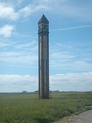 |
Roose Roose Roose or Roosecote is a suburb and ward of Barrow-in-Furness, Cumbria, England. The word 'roose' is Celtic for "moor" or "heath" and the suffix 'cote' of Roosecote means "hut" or "huts"... (Rampside Rampside Rampside is a village in Cumbria, England, located a few miles south-east of the town of Barrow-in-Furness, in the north-western corner of Morecambe Bay on the Furness peninsula.-History:... ) |
1875 | 1991 | NUMBER 4 LEADING LIGHT ON FORESHORE NEAR RAMPSIDE HALL |
| The Concle Public House | Roose Roose Roose or Roosecote is a suburb and ward of Barrow-in-Furness, Cumbria, England. The word 'roose' is Celtic for "moor" or "heath" and the suffix 'cote' of Roosecote means "hut" or "huts"... (Rampside Rampside Rampside is a village in Cumbria, England, located a few miles south-east of the town of Barrow-in-Furness, in the north-western corner of Morecambe Bay on the Furness peninsula.-History:... ) |
c.1800s | 1976 | THE CONCLE PUBLIC HOUSE | |
| Eastwood House | Roose Roose Roose or Roosecote is a suburb and ward of Barrow-in-Furness, Cumbria, England. The word 'roose' is Celtic for "moor" or "heath" and the suffix 'cote' of Roosecote means "hut" or "huts"... (Rampside Rampside Rampside is a village in Cumbria, England, located a few miles south-east of the town of Barrow-in-Furness, in the north-western corner of Morecambe Bay on the Furness peninsula.-History:... ) |
c.1800s | 1993 | EASTWOOD HOUSE | |
| Moorhead Farm | Roose Roose Roose or Roosecote is a suburb and ward of Barrow-in-Furness, Cumbria, England. The word 'roose' is Celtic for "moor" or "heath" and the suffix 'cote' of Roosecote means "hut" or "huts"... (Rampside Rampside Rampside is a village in Cumbria, England, located a few miles south-east of the town of Barrow-in-Furness, in the north-western corner of Morecambe Bay on the Furness peninsula.-History:... ) |
1719 | 1976 | NUMBER 1 MOORHEAD COTTAGES AND ATTACHED BARN | |
| Chetwynde School Chetwynde School Chetwynde School is a non-selective, independent, private school, which takes boys and girls from ages 3 to 18. It includes a nursery, primary school, secondary school and sixth form. The school is situated on a site on Rating Lane in Barrow-in-Furness, Cumbria, England.- History :Chetwynde was... , Main Building |
Newbarns Newbarns Newbarns is an area and electoral ward of Barrow-in-Furness, Cumbria, England. It is bordered by Hawcoat, Parkside, Risedale and Roose, the local population stood at 5,515 in 2001. Newbarns covers an area of 2.78 square kilometres and lies east of Abbey Road, and encompases Furness Abbey, Barrow... |
1865 | 1976 | OUR LADY'S SCHOOL, CROSSLANDS CONVENT | |
| Crosslands Lodge | Newbarns Newbarns Newbarns is an area and electoral ward of Barrow-in-Furness, Cumbria, England. It is bordered by Hawcoat, Parkside, Risedale and Roose, the local population stood at 5,515 in 2001. Newbarns covers an area of 2.78 square kilometres and lies east of Abbey Road, and encompases Furness Abbey, Barrow... |
1875 | 1976 | LODGE TO CROSSLANDS | |
| Manor Farmhouse | Newbarns Newbarns Newbarns is an area and electoral ward of Barrow-in-Furness, Cumbria, England. It is bordered by Hawcoat, Parkside, Risedale and Roose, the local population stood at 5,515 in 2001. Newbarns covers an area of 2.78 square kilometres and lies east of Abbey Road, and encompases Furness Abbey, Barrow... |
1845 | 1976 | MANOR FARMHOUSE | |
| 113-119 Rawlison Street, Former Police Station | Central Barrow Central Barrow Central Barrow refers to the town centre of Barrow-in-Furness, Cumbria, North West England, UK. Central Barrow is also the name of the electoral ward that covers roughly the Eastern part of Barrow Town Centre. In 2001 5,584 lived in the Central ward, with the majority of people being White... |
1880 | 1976 | 113-119 | |
| Victoria Hall | Hindpool Hindpool Hindpool is an area and electoral ward of Barrow-in-Furness, Cumbria, England. It is bordered by Barrow Island, Central Barrow, Ormsgill, Parkside and the Walney Channel, the local population stood at 5,515 in 2001. The ward covers the entire western half of the town centre and includes Barrow's... |
1888 | 1991 | VICTORIA HALL | |
| 1 Chase End, Cross Lane | Hawcoat Hawcoat Hawcoat is a ward of the UK town Barrow-in-Furness, Cumbria, North West England.The ward is one of the few places in Barrow that has been permanently inhabited since the middle ages; Hawcoat was named and identified as Hietun in the Domesday Book. It is the most northerly ward in Barrow and in 2001... |
c.1700s | 1976 | CHASE END 1 | |
| 17 Roanhead Lane | Hawcoat Hawcoat Hawcoat is a ward of the UK town Barrow-in-Furness, Cumbria, North West England.The ward is one of the few places in Barrow that has been permanently inhabited since the middle ages; Hawcoat was named and identified as Hietun in the Domesday Book. It is the most northerly ward in Barrow and in 2001... |
c.1700s | 1976 | NUMBER 17 AND ATTACHED OUTBUILDING | |
| 32 Robert Street | Hindpool Hindpool Hindpool is an area and electoral ward of Barrow-in-Furness, Cumbria, England. It is bordered by Barrow Island, Central Barrow, Ormsgill, Parkside and the Walney Channel, the local population stood at 5,515 in 2001. The ward covers the entire western half of the town centre and includes Barrow's... |
1870 | 1976 | 32 | |
| 1 St. George's Square | Central Barrow Central Barrow Central Barrow refers to the town centre of Barrow-in-Furness, Cumbria, North West England, UK. Central Barrow is also the name of the electoral ward that covers roughly the Eastern part of Barrow Town Centre. In 2001 5,584 lived in the Central ward, with the majority of people being White... |
1864 | 1976 | 1 | |
| St. George's Church of England Church St. George's Church, Barrow-in-Furness St. George's Church is in Central ward of Barrow-in-Furness, Cumbria, England. It is the oldest active Anglican parish church in the deanery of Barrow in the archdeaconry of Westmoreland and Furness . Its benefice is united with those of St Aidan, Newbarns, St Luke, Risedale, and... |
Central Barrow Central Barrow Central Barrow refers to the town centre of Barrow-in-Furness, Cumbria, North West England, UK. Central Barrow is also the name of the electoral ward that covers roughly the Eastern part of Barrow Town Centre. In 2001 5,584 lived in the Central ward, with the majority of people being White... |
1861 | 1976 | CHURCH OF ST GEORGE | |
| Railwaymen's Club | Central Barrow Central Barrow Central Barrow refers to the town centre of Barrow-in-Furness, Cumbria, North West England, UK. Central Barrow is also the name of the electoral ward that covers roughly the Eastern part of Barrow Town Centre. In 2001 5,584 lived in the Central ward, with the majority of people being White... |
1865 | 1976 | RAILWAYMEN'S CLUB AND PREMISES OF HSP PRINTING | |
| 2-10 Salthouse Road | Central Barrow Central Barrow Central Barrow refers to the town centre of Barrow-in-Furness, Cumbria, North West England, UK. Central Barrow is also the name of the electoral ward that covers roughly the Eastern part of Barrow Town Centre. In 2001 5,584 lived in the Central ward, with the majority of people being White... |
1846 | 1976 | 2-10 | |
| 14-20 Salthouse Road | Central Barrow Central Barrow Central Barrow refers to the town centre of Barrow-in-Furness, Cumbria, North West England, UK. Central Barrow is also the name of the electoral ward that covers roughly the Eastern part of Barrow Town Centre. In 2001 5,584 lived in the Central ward, with the majority of people being White... |
1849 | 1976 | 14-20 | |
| 143 Salthouse Road | Central Barrow Central Barrow Central Barrow refers to the town centre of Barrow-in-Furness, Cumbria, North West England, UK. Central Barrow is also the name of the electoral ward that covers roughly the Eastern part of Barrow Town Centre. In 2001 5,584 lived in the Central ward, with the majority of people being White... |
c.1800s | 1976 | 143 | |
| 143 Salthouse Road, Barn | Central Barrow Central Barrow Central Barrow refers to the town centre of Barrow-in-Furness, Cumbria, North West England, UK. Central Barrow is also the name of the electoral ward that covers roughly the Eastern part of Barrow Town Centre. In 2001 5,584 lived in the Central ward, with the majority of people being White... |
c.1700s | 1976 | BARN IMMEDIATELY TO WEST OF NUMBER 143 | |
| 145 and 147 Salthouse Road | Central Barrow Central Barrow Central Barrow refers to the town centre of Barrow-in-Furness, Cumbria, North West England, UK. Central Barrow is also the name of the electoral ward that covers roughly the Eastern part of Barrow Town Centre. In 2001 5,584 lived in the Central ward, with the majority of people being White... |
c.1600s | 1976 | 145 AND 147 | |
| 151 Salthouse Road | Central Barrow Central Barrow Central Barrow refers to the town centre of Barrow-in-Furness, Cumbria, North West England, UK. Central Barrow is also the name of the electoral ward that covers roughly the Eastern part of Barrow Town Centre. In 2001 5,584 lived in the Central ward, with the majority of people being White... |
1802 | 1976 | 151 | |
| 153 Salthouse Road and Farm Buildings | Central Barrow Central Barrow Central Barrow refers to the town centre of Barrow-in-Furness, Cumbria, North West England, UK. Central Barrow is also the name of the electoral ward that covers roughly the Eastern part of Barrow Town Centre. In 2001 5,584 lived in the Central ward, with the majority of people being White... |
c.1700s | 1976 | NUMBER 153 WITH ADJOINING FARM BUILDINGS | |
| St. George's House | Central Barrow Central Barrow Central Barrow refers to the town centre of Barrow-in-Furness, Cumbria, North West England, UK. Central Barrow is also the name of the electoral ward that covers roughly the Eastern part of Barrow Town Centre. In 2001 5,584 lived in the Central ward, with the majority of people being White... |
1860 | 1973 | ST GEORGE'S HOUSE | |
| 4 Newbarns Village | Newbarns Newbarns Newbarns is an area and electoral ward of Barrow-in-Furness, Cumbria, England. It is bordered by Hawcoat, Parkside, Risedale and Roose, the local population stood at 5,515 in 2001. Newbarns covers an area of 2.78 square kilometres and lies east of Abbey Road, and encompases Furness Abbey, Barrow... |
c.1800s | 1976 | NUMBER 4 NEW BARNS VILLAGE | |
| 6-26 School Street | Central Barrow Central Barrow Central Barrow refers to the town centre of Barrow-in-Furness, Cumbria, North West England, UK. Central Barrow is also the name of the electoral ward that covers roughly the Eastern part of Barrow Town Centre. In 2001 5,584 lived in the Central ward, with the majority of people being White... |
c.1800s | 1976 | 6-26 | |
| Trinity Church Trinity Church, Barrow-in-Furness Trinity Church is a former Presbyterian church located on School Street in Barrow-in-Furness, England. The church building was built in 1875 to accommodate the town's large Scottish Presbyterian congregation which had been meeting in the Welsh Chapel for ten years. The church closed around 100... |
Hindpool Hindpool Hindpool is an area and electoral ward of Barrow-in-Furness, Cumbria, England. It is bordered by Barrow Island, Central Barrow, Ormsgill, Parkside and the Walney Channel, the local population stood at 5,515 in 2001. The ward covers the entire western half of the town centre and includes Barrow's... |
1875 | 1976 | PRESBYTERIAN CHURCH | |
| St. George's Church of England Primary School | Hindpool Hindpool Hindpool is an area and electoral ward of Barrow-in-Furness, Cumbria, England. It is bordered by Barrow Island, Central Barrow, Ormsgill, Parkside and the Walney Channel, the local population stood at 5,515 in 2001. The ward covers the entire western half of the town centre and includes Barrow's... |
1849 | 1976 | ST GEORGES CHURCH OF ENGLAND PRIMARY SCHOOL | |
| 1-9 Schooner Street | Barrow Island | 1884 | 1993 | SCHOONER STREET TENEMENTS 1-9 | |
| 1-9 Ship Street | Barrow Island | 1884 | 1993 | SHIP STREET TENEMENT 1-9 | |
| Harbour Hotel | Central Barrow Central Barrow Central Barrow refers to the town centre of Barrow-in-Furness, Cumbria, North West England, UK. Central Barrow is also the name of the electoral ward that covers roughly the Eastern part of Barrow Town Centre. In 2001 5,584 lived in the Central ward, with the majority of people being White... |
1850 | 1976 | HARBOUR HOTEL | |
| 14 Tower Street | Roose Roose Roose or Roosecote is a suburb and ward of Barrow-in-Furness, Cumbria, England. The word 'roose' is Celtic for "moor" or "heath" and the suffix 'cote' of Roosecote means "hut" or "huts"... (Roa Island Roa Island Roa Island lies just over half a mile south of the village of Rampside at the southernmost point of the Furness Peninsula in Cumbria, though formerly in the area of Lancashire north of the sands. It is located at . It is one of the Islands of Furness in northern England. It has an area of about... ) |
c.1800s | 1976 | TOWER HOUSE 14 | |
| Roa Island Watch Tower | Roose Roose Roose or Roosecote is a suburb and ward of Barrow-in-Furness, Cumbria, England. The word 'roose' is Celtic for "moor" or "heath" and the suffix 'cote' of Roosecote means "hut" or "huts"... (Roa Island Roa Island Roa Island lies just over half a mile south of the village of Rampside at the southernmost point of the Furness Peninsula in Cumbria, though formerly in the area of Lancashire north of the sands. It is located at . It is one of the Islands of Furness in northern England. It has an area of about... ) |
1849 | 1976 | WATCH TOWER | |
| Victoria Park Hotel | Parkside Parkside - England :*Parkside railway station, Liverpool and Manchester Railway*Parkside, Barrow-in-Furness*Parkside, Cambridge*Parkside, County Durham*Parkside Community College, Cambridge*Parkside Community College , Devonport, Devon... |
c.1900s | 1976 | VICTORIA PARK HOTEL | |
| John Whinnerah Institute | Hindpool Hindpool Hindpool is an area and electoral ward of Barrow-in-Furness, Cumbria, England. It is bordered by Barrow Island, Central Barrow, Ormsgill, Parkside and the Walney Channel, the local population stood at 5,515 in 2001. The ward covers the entire western half of the town centre and includes Barrow's... |
1938 | 2001 | THE JOHN WHINNERAH INSTITUTE BUILDING WITH GATE PIERS TO FRONT AND BICYCLE SHED IN REAR WALL |