

List of lighthouses in the Netherlands
Encyclopedia
Active
| Lighthouse | Town | Province | Height | Light | Year | Architect | Photo |
|---|---|---|---|---|---|---|---|
| Urk Lighthouse Urk Lighthouse Urk Lighthouse is a lighthouse in Urk at the eastern banks of the IJsselmeer. From 1617 a coal fire was used for the local fishermen as well as for the ships sailing from Amsterdam to the North Sea. The current lighthouse station was established in 1837. The tower was built in 1845 as a round brick... |
Urk Urk Urk is a municipality and a town in the Flevoland province in the central Netherlands.Urk is first mentioned in historical records dating to the 10th century, when it was still an island in the Almere, a lake that would become part of the Zuiderzee in the 13th century after a series of incursions... |
Flevoland Flevoland Flevoland is a province of the Netherlands. Located in the centre of the country, at the location of the former Zuiderzee, the province was established on January 1, 1986; the twelfth province of the country, with Lelystad as its capital... |
18,5 m (27 m above NAP Normaal Amsterdams Peil Normaal Amsterdams Peil or Amsterdam Ordnance Datum is a vertical datum in use in large parts of Western Europe. Originally created for use in the Netherlands, it was adopted by Prussia in 1879 under the name Normalnull, and in 1955 by other European countries.Mayor Johannes Hudde of Amsterdam in... ) |
Fl W 5s (18 nautical miles (33 km)) | 1844-1845 | Valk, J. | |
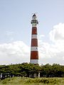
| Bornrif Bornrif The Ameland Lighthouse, commonly known as Bornrif, is a lighthouse on the Dutch island Ameland, one of the Frisian Islands, on the edge of the North Sea. It was built in 1880 by order of William III of the Netherlands. It was designed by Dutch lighthouse architect Quirinus Harder and built by the... |
Ameland Ameland Ameland is a municipality and one of the West Frisian Islands off the north coast of the Netherlands. It consists mostly of sand dunes. It is the third major island of the West Frisians. It neighbours islands Terschelling to the West and Schiermonnikoog to the East... |
Friesland Friesland Friesland is a province in the north of the Netherlands and part of the ancient region of Frisia.Until the end of 1996, the province bore Friesland as its official name. In 1997 this Dutch name lost its official status to the Frisian Fryslân... |
55,3 m (58 m above NAP Normaal Amsterdams Peil Normaal Amsterdams Peil or Amsterdam Ordnance Datum is a vertical datum in use in large parts of Western Europe. Originally created for use in the Netherlands, it was adopted by Prussia in 1879 under the name Normalnull, and in 1955 by other European countries.Mayor Johannes Hudde of Amsterdam in... ) |
Fl(3) W 15s (30 nautical miles (56 km)) | 1880-1881 | Harder, Quirinus Quirinus Harder Quirinus Harder was a Dutch architect best known for having designed a large number of lighthouses. He worked as a structural engineer for the Loodswezen, the Dutch organization overseeing all maritime pilots... |
 |
| North Tower North Tower (lighthouse) The North Tower is the unofficial name for one of the lighthouses on the Dutch island Schiermonnikoog, one of the Frisian Islands, on the edge of the North Sea; the other is the South Tower. It was built by H.G. Jansen & A. van Rhyn, and was activated in 1854. From the tower, weather reports are... |
Schiermonnikoog Schiermonnikoog Schiermonnikoog is an island, a municipality, and a national park in the northern Netherlands. Schiermonnikoog is one of the West Frisian Islands, and is part of the province of Friesland.... |
Friesland Friesland Friesland is a province in the north of the Netherlands and part of the ancient region of Frisia.Until the end of 1996, the province bore Friesland as its official name. In 1997 this Dutch name lost its official status to the Frisian Fryslân... |
37 m (44 m above NAP Normaal Amsterdams Peil Normaal Amsterdams Peil or Amsterdam Ordnance Datum is a vertical datum in use in large parts of Western Europe. Originally created for use in the Netherlands, it was adopted by Prussia in 1879 under the name Normalnull, and in 1955 by other European countries.Mayor Johannes Hudde of Amsterdam in... ) |
Fl(4) W 20s (28 nautical miles (52 km)) | 1853-1854 | Jansen, H.G. | 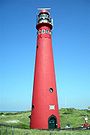 |
| Stavoren Lighthouse Stavoren Lighthouse The Stavoren Lighthouse is a lighthouse near Stavoren on the IJsselmeer, in the Netherlands. On two nearby piers are a red and a green light beacon for the Stavoren harbor. All were built in 1885 and are Rijksmonuments since 1999. The lighthouse was restored in 2001.-External links:*... |
Stavoren Stavoren Stavoren is a small town on the coast of the IJsselmeer, about 5 km south of Hindeloopen. It lies within the municipality of Súdwest-Fryslân. Stavoren was granted city rights in 1118, making it the oldest city in Friesland... |
Friesland Friesland Friesland is a province in the north of the Netherlands and part of the ancient region of Frisia.Until the end of 1996, the province bore Friesland as its official name. In 1997 this Dutch name lost its official status to the Frisian Fryslân... |
15,7 m (15 m above NAP Normaal Amsterdams Peil Normaal Amsterdams Peil or Amsterdam Ordnance Datum is a vertical datum in use in large parts of Western Europe. Originally created for use in the Netherlands, it was adopted by Prussia in 1879 under the name Normalnull, and in 1955 by other European countries.Mayor Johannes Hudde of Amsterdam in... ) |
Iso W 4s (12 nautical miles (22 km)) | 1884 | Harder, Quirinus | 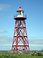 |
| Brandaris Brandaris The Brandaris is a lighthouse on the Dutch Wadden Sea island Terschelling, in Friesland. The first Brandaris was built in 1323, but it was destroyed in 1570. The current tower was built in 1594 and is listed as a Rijksmonument, number 35032 and is rated with a very high historical value.-External... |
Terschelling Terschelling Terschelling is a municipality and an island in the northern Netherlands, one of the West Frisian Islands.Waddenislanders are known for their resourcefulness in using anything and everything that washes ashore. With few trees to use for timber, most of the farms and barns are built with masts... |
Friesland Friesland Friesland is a province in the north of the Netherlands and part of the ancient region of Frisia.Until the end of 1996, the province bore Friesland as its official name. In 1997 this Dutch name lost its official status to the Frisian Fryslân... |
52,5 m (55 m above NAP Normaal Amsterdams Peil Normaal Amsterdams Peil or Amsterdam Ordnance Datum is a vertical datum in use in large parts of Western Europe. Originally created for use in the Netherlands, it was adopted by Prussia in 1879 under the name Normalnull, and in 1955 by other European countries.Mayor Johannes Hudde of Amsterdam in... ) |
Fl W 5s (29 nautical miles (54 km)) | 1593-1594 | 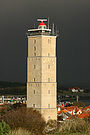 |
|
| Vuurduin Vuurduin Vuurduin is a lighthouse on the Dutch island Vlieland. The tower is the top part of the former front light of the leading lights in IJmuiden, designed by Quirinus Harder.... |
Vlieland Vlieland Vlieland is a municipality in the northern Netherlands. The municipality of Vlieland has only one major town: Oost-Vlieland . It is the second-least densely populated municipality in the Netherlands .... |
Friesland Friesland Friesland is a province in the north of the Netherlands and part of the ancient region of Frisia.Until the end of 1996, the province bore Friesland as its official name. In 1997 this Dutch name lost its official status to the Frisian Fryslân... |
16,8 m (54 m above NAP Normaal Amsterdams Peil Normaal Amsterdams Peil or Amsterdam Ordnance Datum is a vertical datum in use in large parts of Western Europe. Originally created for use in the Netherlands, it was adopted by Prussia in 1879 under the name Normalnull, and in 1955 by other European countries.Mayor Johannes Hudde of Amsterdam in... ) |
Iso W 4s (20 nautical miles (37 km)) | 1909 | Harder, Quirinus | 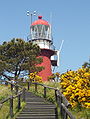 |
| Lange Jaap Lange Jaap Lange Jaap , also known as Kijkduin Light or Den Helder Light, is an active lighthouse near fort Kijkduin in Huisduinen, municipality of Den Helder, province of North Holland, the Netherlands. At a height of it is one of the tallest "traditional lighthouse" in the world... |
Den Helder Den Helder Den Helder is a municipality and a city in the Netherlands, in the province of North Holland. Den Helder occupies the northernmost point of the North Holland peninsula... |
North Holland North Holland North Holland |West Frisian]]: Noard-Holland) is a province situated on the North Sea in the northwest part of the Netherlands. The provincial capital is Haarlem and its largest city is Amsterdam.-Geography:... |
55,5 m (57 m above NAP Normaal Amsterdams Peil Normaal Amsterdams Peil or Amsterdam Ordnance Datum is a vertical datum in use in large parts of Western Europe. Originally created for use in the Netherlands, it was adopted by Prussia in 1879 under the name Normalnull, and in 1955 by other European countries.Mayor Johannes Hudde of Amsterdam in... ) |
Fl(4) W 20s (30 nautical miles (56 km)) | 1877-1878 | Harder, Quirinus |  |
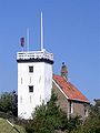
| Den Oever Lighthouse Den Oever Lighthouse The Den Oever Lighthouse is a cast iron lighthouse in Den Oever, the Netherlands, on the Wadden Sea. It was probably designed by Quirinus Harder, and was built in 1884 by Penn & Bauduin of Dordrecht.... |
Den Oever Den Oever Den Oever is a village in the Dutch province of North Holland. It is a part of the municipality of Wieringen, and lies about east of Den Helder... |
North Holland North Holland North Holland |West Frisian]]: Noard-Holland) is a province situated on the North Sea in the northwest part of the Netherlands. The provincial capital is Haarlem and its largest city is Amsterdam.-Geography:... |
15 m above NAP Normaal Amsterdams Peil Normaal Amsterdams Peil or Amsterdam Ordnance Datum is a vertical datum in use in large parts of Western Europe. Originally created for use in the Netherlands, it was adopted by Prussia in 1879 under the name Normalnull, and in 1955 by other European countries.Mayor Johannes Hudde of Amsterdam in... |
Iso WRG 5s (10 nautical miles (19 km)) | 1884 | Harder, Quirinus | |
| J.C.J. van Speijk Lighthouse J.C.J. van Speijk Lighthouse The J.C.J. van Speijk Lighthouse is a lighthouse on the North Sea coast near Egmond aan Zee, in the municipality of Bergen, North Holland, in the Netherlands... |
Egmond aan Zee Egmond aan Zee Egmond aan Zee is a village on the North Sea coast in the Dutch province of North Holland. It is a part of the municipality of Bergen, and lies about 9 km west of Alkmaar.... |
North Holland North Holland North Holland |West Frisian]]: Noard-Holland) is a province situated on the North Sea in the northwest part of the Netherlands. The provincial capital is Haarlem and its largest city is Amsterdam.-Geography:... |
28 m (37 m above NAP Normaal Amsterdams Peil Normaal Amsterdams Peil or Amsterdam Ordnance Datum is a vertical datum in use in large parts of Western Europe. Originally created for use in the Netherlands, it was adopted by Prussia in 1879 under the name Normalnull, and in 1955 by other European countries.Mayor Johannes Hudde of Amsterdam in... ) |
Iso WR 10s (18 nautical miles (33 km)) | 1833-1834 | Valk, J. | |
| Hoge vuurtoren van IJmuiden Hoge vuurtoren van IJmuiden The hoge vuurtoren van IJmuiden is a round, cast-iron lighthouse in IJmuiden, Netherlands, designed by Quirinus Harder. It was built in 1878 by D.A... |
IJmuiden | North Holland North Holland North Holland |West Frisian]]: Noard-Holland) is a province situated on the North Sea in the northwest part of the Netherlands. The provincial capital is Haarlem and its largest city is Amsterdam.-Geography:... |
41,8 m (53 m above NAP Normaal Amsterdams Peil Normaal Amsterdams Peil or Amsterdam Ordnance Datum is a vertical datum in use in large parts of Western Europe. Originally created for use in the Netherlands, it was adopted by Prussia in 1879 under the name Normalnull, and in 1955 by other European countries.Mayor Johannes Hudde of Amsterdam in... ) |
Fl W 5s (29 nautical miles (54 km)) | 1878 | Harder, Quirinus | |
| Lage vuurtoren van IJmuiden Lage vuurtoren van IJmuiden The Lage vuurtoren van IJmuiden is a round, cast-iron lighthouse in IJmuiden, Netherlands, designed by Quirinus Harder. It was built in 1878 by D.A. Schretlen & Co, a company in Leiden and activated the following year. In 1909, the top three sections were moved to Vlieland where they serve as a... |
IJmuiden | North Holland North Holland North Holland |West Frisian]]: Noard-Holland) is a province situated on the North Sea in the northwest part of the Netherlands. The provincial capital is Haarlem and its largest city is Amsterdam.-Geography:... |
24 m (31 m above NAP Normaal Amsterdams Peil Normaal Amsterdams Peil or Amsterdam Ordnance Datum is a vertical datum in use in large parts of Western Europe. Originally created for use in the Netherlands, it was adopted by Prussia in 1879 under the name Normalnull, and in 1955 by other European countries.Mayor Johannes Hudde of Amsterdam in... ) |
F WR (16 nautical miles (30 km)) | 1878 | Harder, Quirinus | |
| Groote Kaap Groote Kaap Groote Kaap is a round steel lighthouse painted red with a white light casing on the North Sea coast in the dunes near Julianadorp by the sea, in the municipality of Den Helder. The construction of the tower was completed in 1966... |
Julianadorp Julianadorp Julianadorp is a town in the Dutch province of North Holland. It is a part of the municipality of Den Helder, and lies about 6 km south of Den Helder.It was formed in 1909, and named after Princess Juliana who was born that same year.... |
North Holland North Holland North Holland |West Frisian]]: Noard-Holland) is a province situated on the North Sea in the northwest part of the Netherlands. The provincial capital is Haarlem and its largest city is Amsterdam.-Geography:... |
16,8 m (31 m above NAP Normaal Amsterdams Peil Normaal Amsterdams Peil or Amsterdam Ordnance Datum is a vertical datum in use in large parts of Western Europe. Originally created for use in the Netherlands, it was adopted by Prussia in 1879 under the name Normalnull, and in 1955 by other European countries.Mayor Johannes Hudde of Amsterdam in... ) |
Oc WRG 10s (11 nautical miles (20 km)) | 1966 | ||
| Paard van Marken Paard van Marken The Paard van Marken is a lighthouse on the Dutch peninsula Marken, on the IJsselmeer. It was built in 1839 by J. Valk. A primitive lighthouse had been on the location since the early 1700s; the current lighthouse is a Rijksmonument since 1970.... |
Marken Marken Marken is a peninsula in the IJsselmeer, the Netherlands, located in the municipality Waterland in the province North Holland. It is an island, which nowadays is connected to the North Holland mainland by a causeway. Also, Marken is a well-known tourist attraction, well-known for its characteristic... |
North Holland North Holland North Holland |West Frisian]]: Noard-Holland) is a province situated on the North Sea in the northwest part of the Netherlands. The provincial capital is Haarlem and its largest city is Amsterdam.-Geography:... |
15,5 m (16 m above NAP Normaal Amsterdams Peil Normaal Amsterdams Peil or Amsterdam Ordnance Datum is a vertical datum in use in large parts of Western Europe. Originally created for use in the Netherlands, it was adopted by Prussia in 1879 under the name Normalnull, and in 1955 by other European countries.Mayor Johannes Hudde of Amsterdam in... ) |
Oc W 8s (9 nautical miles (17 km)) | 1839 | Valk, J. | |
| De Ven De Ven De Ven is a lighthouse in Oosterdijk, a village now in the city of Enkhuizen, Netherlands. Built in 1699-1700, it is one of the oldest lighthouses in the Netherlands.-History:... |
Oosterdijk | North Holland North Holland North Holland |West Frisian]]: Noard-Holland) is a province situated on the North Sea in the northwest part of the Netherlands. The provincial capital is Haarlem and its largest city is Amsterdam.-Geography:... |
15 m (17 m above NAP Normaal Amsterdams Peil Normaal Amsterdams Peil or Amsterdam Ordnance Datum is a vertical datum in use in large parts of Western Europe. Originally created for use in the Netherlands, it was adopted by Prussia in 1879 under the name Normalnull, and in 1955 by other European countries.Mayor Johannes Hudde of Amsterdam in... ) |
LFlW10s (11 nautical miles (20 km)) | 1700 | ||
| Eierland Lighthouse Eierland Lighthouse The Eierland Lighthouse is a lighthouse on the northernmost tip of the Dutch island of Texel. It is named for a former island. The lighthouse was designed by Quirinus Harder and construction began on 25 July 1863. The lighthouse was built on top of a 20-metre high sand dune, and was lit on 1... |
Texel Texel Texel is a municipality and an island in the Netherlands, in the province of North Holland. It is the biggest and most populated of the Frisian Islands in the Wadden Sea, and also the westernmost of this archipelago, which extends to Denmark... |
North Holland North Holland North Holland |West Frisian]]: Noard-Holland) is a province situated on the North Sea in the northwest part of the Netherlands. The provincial capital is Haarlem and its largest city is Amsterdam.-Geography:... |
34,7 m (53 m above NAP Normaal Amsterdams Peil Normaal Amsterdams Peil or Amsterdam Ordnance Datum is a vertical datum in use in large parts of Western Europe. Originally created for use in the Netherlands, it was adopted by Prussia in 1879 under the name Normalnull, and in 1955 by other European countries.Mayor Johannes Hudde of Amsterdam in... ) |
Fl(2) W 10s (29 nautical miles (54 km)) | 1863-1864 | Harder, Quirinus | |
| Nieuwe Sluis Nieuwe Sluis Nieuwe Sluis is a lighthouse in the Nieuwesluis community, a few miles west of Breskens, Netherlands. Designed by Quirinus Harder, it was built between 1866 and 1867. The octagonal, black and white tower marks the entrance to the Westerschelde. The tower is 28,4 meters tall and consists of five... |
Breskens Breskens Breskens is a harbour town on the Westerschelde in the municipality of Sluis in the province of Zeeland, in the south-western Netherlands. Its population is 4,280 .... |
Zeeland Zeeland Zeeland , also called Zealand in English, is the westernmost province of the Netherlands. The province, located in the south-west of the country, consists of a number of islands and a strip bordering Belgium. Its capital is Middelburg. With a population of about 380,000, its area is about... |
22,4 m (28 m above NAP Normaal Amsterdams Peil Normaal Amsterdams Peil or Amsterdam Ordnance Datum is a vertical datum in use in large parts of Western Europe. Originally created for use in the Netherlands, it was adopted by Prussia in 1879 under the name Normalnull, and in 1955 by other European countries.Mayor Johannes Hudde of Amsterdam in... ) |
Oc WRG 10s (14 nautical miles (26 km)) | 1867 | Harder, Quirinus | |
| Westerlichttoren Westerlichttoren The Westerlichttoren or West Schouwen is a lighthouse in Haamstede in the province of Zeeland in the Netherlands. Designed by L. Valk, it was built in 1837. At 53 m above ground and a light stand at 58 m above sea level it is one of the tallest lighthouses in the Netherlands.The lighthouse is built... (Westenschouwen) |
Haamstede Haamstede Haamstede is a town in the Dutch province of Zeeland. It is a part of the municipality of Schouwen-Duiveland.The statistical area "Haamstede", which also can include the surrounding countryside, has a population of around 2460.... |
Zeeland Zeeland Zeeland , also called Zealand in English, is the westernmost province of the Netherlands. The province, located in the south-west of the country, consists of a number of islands and a strip bordering Belgium. Its capital is Middelburg. With a population of about 380,000, its area is about... |
50 m (58 m above NAP Normaal Amsterdams Peil Normaal Amsterdams Peil or Amsterdam Ordnance Datum is a vertical datum in use in large parts of Western Europe. Originally created for use in the Netherlands, it was adopted by Prussia in 1879 under the name Normalnull, and in 1955 by other European countries.Mayor Johannes Hudde of Amsterdam in... ) |
Fl(2+1) W 15s (30 nautical miles (56 km)) | 1837-1840 | Valk, L. | |
| Tall lighthouse of Westkapelle | Westkapelle Westkapelle Westkapelle can refer to:* Westkapelle - a place in the municipality of Knokke-Heist in Belgium* Westkapelle - a place in the municipality of Veere in the Netherlands... |
Zeeland Zeeland Zeeland , also called Zealand in English, is the westernmost province of the Netherlands. The province, located in the south-west of the country, consists of a number of islands and a strip bordering Belgium. Its capital is Middelburg. With a population of about 380,000, its area is about... |
52,3 m (49 m above NAP Normaal Amsterdams Peil Normaal Amsterdams Peil or Amsterdam Ordnance Datum is a vertical datum in use in large parts of Western Europe. Originally created for use in the Netherlands, it was adopted by Prussia in 1879 under the name Normalnull, and in 1955 by other European countries.Mayor Johannes Hudde of Amsterdam in... ) |
Fl W 3s (28 nautical miles (52 km)) | 1818; 1458-1470 | ||
| Short lighthouse of Westkapelle (Noorderhoofd) | Westkapelle Westkapelle Westkapelle can refer to:* Westkapelle - a place in the municipality of Knokke-Heist in Belgium* Westkapelle - a place in the municipality of Veere in the Netherlands... |
Zeeland Zeeland Zeeland , also called Zealand in English, is the westernmost province of the Netherlands. The province, located in the south-west of the country, consists of a number of islands and a strip bordering Belgium. Its capital is Middelburg. With a population of about 380,000, its area is about... |
16,1 m (20 m above NAP Normaal Amsterdams Peil Normaal Amsterdams Peil or Amsterdam Ordnance Datum is a vertical datum in use in large parts of Western Europe. Originally created for use in the Netherlands, it was adopted by Prussia in 1879 under the name Normalnull, and in 1955 by other European countries.Mayor Johannes Hudde of Amsterdam in... ) |
Oc WRG 10s (13 nautical miles (24 km)) | 1875 | Harder, Quirinus | |
| Hellevoetsluis Lighthouse | Hellevoetsluis Hellevoetsluis Hellevoetsluis is a small city and municipality on Voorne-Putten Island in the western Netherlands, in the province of South Holland... |
South Holland South Holland South Holland is a province situated on the North Sea in the western part of the Netherlands. The provincial capital is The Hague and its largest city is Rotterdam.South Holland is one of the most densely populated and industrialised areas in the world... |
18,1 m (17 m above NAP Normaal Amsterdams Peil Normaal Amsterdams Peil or Amsterdam Ordnance Datum is a vertical datum in use in large parts of Western Europe. Originally created for use in the Netherlands, it was adopted by Prussia in 1879 under the name Normalnull, and in 1955 by other European countries.Mayor Johannes Hudde of Amsterdam in... ) |
Iso WRG 10s (11 nautical miles (20 km)) | 1822 | Valk, J. | |
| Westhoofd Lighthouse | Ouddorp | South Holland South Holland South Holland is a province situated on the North Sea in the western part of the Netherlands. The provincial capital is The Hague and its largest city is Rotterdam.South Holland is one of the most densely populated and industrialised areas in the world... |
52 m (56 m above NAP Normaal Amsterdams Peil Normaal Amsterdams Peil or Amsterdam Ordnance Datum is a vertical datum in use in large parts of Western Europe. Originally created for use in the Netherlands, it was adopted by Prussia in 1879 under the name Normalnull, and in 1955 by other European countries.Mayor Johannes Hudde of Amsterdam in... ) |
Fl(3) W 15s (30 nautical miles (56 km)) | 1947-1948 | Friedhoff, G. | |
| Noordwijk Lighthouse | Noordwijk Noordwijk Noordwijk is a town and municipality in the western Netherlands, in the province of South Holland. The municipality covers an area of 51.53 km² and had a population of 24,707 in May 2006.... |
South Holland South Holland South Holland is a province situated on the North Sea in the western part of the Netherlands. The provincial capital is The Hague and its largest city is Rotterdam.South Holland is one of the most densely populated and industrialised areas in the world... |
25,5 m (33 m above NAP Normaal Amsterdams Peil Normaal Amsterdams Peil or Amsterdam Ordnance Datum is a vertical datum in use in large parts of Western Europe. Originally created for use in the Netherlands, it was adopted by Prussia in 1879 under the name Normalnull, and in 1955 by other European countries.Mayor Johannes Hudde of Amsterdam in... ) |
Oc(3) W 20s (18 nautical miles (33 km)) | 1921-1922 | Jelsma, C. | |
| Hoge vuurtoren Europoort | Rotterdam Rotterdam Rotterdam is the second-largest city in the Netherlands and one of the largest ports in the world. Starting as a dam on the Rotte river, Rotterdam has grown into a major international commercial centre... |
South Holland South Holland South Holland is a province situated on the North Sea in the western part of the Netherlands. The provincial capital is The Hague and its largest city is Rotterdam.South Holland is one of the most densely populated and industrialised areas in the world... |
44 m above NAP Normaal Amsterdams Peil Normaal Amsterdams Peil or Amsterdam Ordnance Datum is a vertical datum in use in large parts of Western Europe. Originally created for use in the Netherlands, it was adopted by Prussia in 1879 under the name Normalnull, and in 1955 by other European countries.Mayor Johannes Hudde of Amsterdam in... |
Oc G 6s (16 nautical miles (30 km)) | |||
| Lage vuurtoren Europoort | Rotterdam Rotterdam Rotterdam is the second-largest city in the Netherlands and one of the largest ports in the world. Starting as a dam on the Rotte river, Rotterdam has grown into a major international commercial centre... |
South Holland South Holland South Holland is a province situated on the North Sea in the western part of the Netherlands. The provincial capital is The Hague and its largest city is Rotterdam.South Holland is one of the most densely populated and industrialised areas in the world... |
30 m above NAP Normaal Amsterdams Peil Normaal Amsterdams Peil or Amsterdam Ordnance Datum is a vertical datum in use in large parts of Western Europe. Originally created for use in the Netherlands, it was adopted by Prussia in 1879 under the name Normalnull, and in 1955 by other European countries.Mayor Johannes Hudde of Amsterdam in... |
Oc G 6s (16 nautical miles (30 km)) | |||
| Hoge vuurtoren Maasmond | Rotterdam Rotterdam Rotterdam is the second-largest city in the Netherlands and one of the largest ports in the world. Starting as a dam on the Rotte river, Rotterdam has grown into a major international commercial centre... |
South Holland South Holland South Holland is a province situated on the North Sea in the western part of the Netherlands. The provincial capital is The Hague and its largest city is Rotterdam.South Holland is one of the most densely populated and industrialised areas in the world... |
47 m above NAP Normaal Amsterdams Peil Normaal Amsterdams Peil or Amsterdam Ordnance Datum is a vertical datum in use in large parts of Western Europe. Originally created for use in the Netherlands, it was adopted by Prussia in 1879 under the name Normalnull, and in 1955 by other European countries.Mayor Johannes Hudde of Amsterdam in... |
Iso W 4s (21 nautical miles (39 km)) | 1971 | ||
| Lage vuurtoren Maasmond | Rotterdam Rotterdam Rotterdam is the second-largest city in the Netherlands and one of the largest ports in the world. Starting as a dam on the Rotte river, Rotterdam has grown into a major international commercial centre... |
South Holland South Holland South Holland is a province situated on the North Sea in the western part of the Netherlands. The provincial capital is The Hague and its largest city is Rotterdam.South Holland is one of the most densely populated and industrialised areas in the world... |
30 m above NAP Normaal Amsterdams Peil Normaal Amsterdams Peil or Amsterdam Ordnance Datum is a vertical datum in use in large parts of Western Europe. Originally created for use in the Netherlands, it was adopted by Prussia in 1879 under the name Normalnull, and in 1955 by other European countries.Mayor Johannes Hudde of Amsterdam in... |
Iso W 4s (21 nautical miles (39 km)) | 1971 | ||
| Lighthouse at the Maasvlakte | Rotterdam Rotterdam Rotterdam is the second-largest city in the Netherlands and one of the largest ports in the world. Starting as a dam on the Rotte river, Rotterdam has grown into a major international commercial centre... |
South Holland South Holland South Holland is a province situated on the North Sea in the western part of the Netherlands. The provincial capital is The Hague and its largest city is Rotterdam.South Holland is one of the most densely populated and industrialised areas in the world... |
62 m (67 m above NAP Normaal Amsterdams Peil Normaal Amsterdams Peil or Amsterdam Ordnance Datum is a vertical datum in use in large parts of Western Europe. Originally created for use in the Netherlands, it was adopted by Prussia in 1879 under the name Normalnull, and in 1955 by other European countries.Mayor Johannes Hudde of Amsterdam in... ) |
Fl(5) W 20s (28 nautical miles (52 km)) | 1974 | Colenbrander, W. | |
| Hoge vuurtoren Nieuwe Waterweg | Rotterdam Rotterdam Rotterdam is the second-largest city in the Netherlands and one of the largest ports in the world. Starting as a dam on the Rotte river, Rotterdam has grown into a major international commercial centre... |
South Holland South Holland South Holland is a province situated on the North Sea in the western part of the Netherlands. The provincial capital is The Hague and its largest city is Rotterdam.South Holland is one of the most densely populated and industrialised areas in the world... |
44 m above NAP Normaal Amsterdams Peil Normaal Amsterdams Peil or Amsterdam Ordnance Datum is a vertical datum in use in large parts of Western Europe. Originally created for use in the Netherlands, it was adopted by Prussia in 1879 under the name Normalnull, and in 1955 by other European countries.Mayor Johannes Hudde of Amsterdam in... |
Iso R 6s (18 nautical miles (33 km)) | |||
| Lage vuurtoren Nieuwe Waterweg | Rotterdam Rotterdam Rotterdam is the second-largest city in the Netherlands and one of the largest ports in the world. Starting as a dam on the Rotte river, Rotterdam has grown into a major international commercial centre... |
South Holland South Holland South Holland is a province situated on the North Sea in the western part of the Netherlands. The provincial capital is The Hague and its largest city is Rotterdam.South Holland is one of the most densely populated and industrialised areas in the world... |
30 m above NAP Normaal Amsterdams Peil Normaal Amsterdams Peil or Amsterdam Ordnance Datum is a vertical datum in use in large parts of Western Europe. Originally created for use in the Netherlands, it was adopted by Prussia in 1879 under the name Normalnull, and in 1955 by other European countries.Mayor Johannes Hudde of Amsterdam in... |
Iso R 6s (18 nautical miles (33 km)) | |||
| Scheveningen Lighthouse Scheveningen Lighthouse De Scheveningen Lighthouse is a lighthouse in Scheveningen, Netherlands. It was designed by Quirinus Harder and activated finished in 1875.-History:... |
Scheveningen | South Holland South Holland South Holland is a province situated on the North Sea in the western part of the Netherlands. The provincial capital is The Hague and its largest city is Rotterdam.South Holland is one of the most densely populated and industrialised areas in the world... |
30 m (49 m above NAP Normaal Amsterdams Peil Normaal Amsterdams Peil or Amsterdam Ordnance Datum is a vertical datum in use in large parts of Western Europe. Originally created for use in the Netherlands, it was adopted by Prussia in 1879 under the name Normalnull, and in 1955 by other European countries.Mayor Johannes Hudde of Amsterdam in... ) |
Fl(2) W 10s (29 nautical miles (54 km)) | 1875 | Harder, Quirinus | |
| Vuurtoreneiland Vuurtoreneiland Vuurtoreneiland is a small island in the IJmeer, the Netherlands, just off the coast of Durgerdam. The island's main function is as a base for a lighthouse; a military fort on the island was abandoned in the 1930s.... |
Durgerdam Durgerdam Durgerdam is a village in the Dutch province of North Holland. It is a part of the municipality of Amsterdam, and lies about 7 km east of the city centre, along the dyke of the IJsselmeer.... |
North Holland North Holland North Holland |West Frisian]]: Noard-Holland) is a province situated on the North Sea in the northwest part of the Netherlands. The provincial capital is Haarlem and its largest city is Amsterdam.-Geography:... |
19,5 m (18 m above NAP Normaal Amsterdams Peil Normaal Amsterdams Peil or Amsterdam Ordnance Datum is a vertical datum in use in large parts of Western Europe. Originally created for use in the Netherlands, it was adopted by Prussia in 1879 under the name Normalnull, and in 1955 by other European countries.Mayor Johannes Hudde of Amsterdam in... ) |
Oc WR 5s (14 nautical miles (26 km)) | 1893-2003, 2005- | Loo, A.C. van |
Deactivated
| Lighthouse | Town | Province | Deactivated | Height | Light | Year | Architect | Photo |
|---|---|---|---|---|---|---|---|---|
| Harlingen Lighthouse | Harlingen | Friesland Friesland Friesland is a province in the north of the Netherlands and part of the ancient region of Frisia.Until the end of 1996, the province bore Friesland as its official name. In 1997 this Dutch name lost its official status to the Frisian Fryslân... |
1998 | 21 m above NAP Normaal Amsterdams Peil Normaal Amsterdams Peil or Amsterdam Ordnance Datum is a vertical datum in use in large parts of Western Europe. Originally created for use in the Netherlands, it was adopted by Prussia in 1879 under the name Normalnull, and in 1955 by other European countries.Mayor Johannes Hudde of Amsterdam in... |
F WR | 1921 | Jelsma, C. | |
| Lemmer Lighthouse | Lemmer Lemmer Lemmer is a town in the municipality of Lemsterland , in the Netherlands. It has a population of around 10,500 and is one of Friesland's most famous water sport towns.Lemmer also is a common Luxembourgish last name.... |
Friesland Friesland Friesland is a province in the north of the Netherlands and part of the ancient region of Frisia.Until the end of 1996, the province bore Friesland as its official name. In 1997 this Dutch name lost its official status to the Frisian Fryslân... |
1993 | 19,2 m | 1993 | 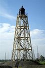 |
||
| Zuidertoren | Schiermonnikoog Schiermonnikoog Schiermonnikoog is an island, a municipality, and a national park in the northern Netherlands. Schiermonnikoog is one of the West Frisian Islands, and is part of the province of Friesland.... |
Friesland Friesland Friesland is a province in the north of the Netherlands and part of the ancient region of Frisia.Until the end of 1996, the province bore Friesland as its official name. In 1997 this Dutch name lost its official status to the Frisian Fryslân... |
1909 | 1853-1854 | Jansen, H.G. | 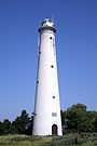 |
||
| Workum Lighthouse | Workum Workum Workum is the largest town of Nijefurd in Friesland. It received city rights in 1374. It lies within the municipality of Nijefurd. Currently has around 4000 inhabitants.... |
Friesland Friesland Friesland is a province in the north of the Netherlands and part of the ancient region of Frisia.Until the end of 1996, the province bore Friesland as its official name. In 1997 this Dutch name lost its official status to the Frisian Fryslân... |
 |
|||||
| Stenen Baak | Brielle Brielle Brielle , also called Den Briel is a town and municipality in the western Netherlands, in the province of South Holland, on the north side of the island of Voorne-Putten, at the mouth of the New Maas. The municipality covers an area of 31.12 km² of which 3.63 km² is water... |
Zuid-Holland | 1850 | 15 m | 1630 | Paeyse, M. Czn | ||
| Goedereede Lighthouse | Goedereede Goedereede Goedereede is a municipality and a town in the western Netherlands, in the province of South Holland. The municipality had a population of 11408 in 2010, and covers an area of 153.85 km² of which 82.53 km² is water... |
South Holland South Holland South Holland is a province situated on the North Sea in the western part of the Netherlands. The provincial capital is The Hague and its largest city is Rotterdam.South Holland is one of the most densely populated and industrialised areas in the world... |
1991 | 19,5 m | 1467-1512, lighthouse since 1834 | |||
| Hoge vuurtoren van Hoek van Holland | Hoek van Holland Hoek van Holland The Hook of Holland , also known in English as the Hook, is a town in South Holland in the Netherlands. It is situated on the North Sea coast, on the north bank of the Nieuwe Waterweg ship canal. The town is administered by the municipality of Rotterdam as a district of that city... |
South Holland South Holland South Holland is a province situated on the North Sea in the western part of the Netherlands. The provincial capital is The Hague and its largest city is Rotterdam.South Holland is one of the most densely populated and industrialised areas in the world... |
1974 | 1893 | Loo, A.C. van | |||
| Hoek van Holland Lighthouse | Hoek van Holland Hoek van Holland The Hook of Holland , also known in English as the Hook, is a town in South Holland in the Netherlands. It is situated on the North Sea coast, on the north bank of the Nieuwe Waterweg ship canal. The town is administered by the municipality of Rotterdam as a district of that city... |
South Holland South Holland South Holland is a province situated on the North Sea in the western part of the Netherlands. The provincial capital is The Hague and its largest city is Rotterdam.South Holland is one of the most densely populated and industrialised areas in the world... |
1967 | 13,5 m | 1899 | Loo, A.C. van | ||
| Katwijk Lighthouse | Katwijk Katwijk Katwijk is a coastal municipality and town in the province of South Holland in the western Netherlands. It has a population of 61,292.-Location:... |
South Holland South Holland South Holland is a province situated on the North Sea in the western part of the Netherlands. The provincial capital is The Hague and its largest city is Rotterdam.South Holland is one of the most densely populated and industrialised areas in the world... |
1913 | 1605 | 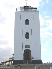 |
Demolished
| Lighthouse | Town | Province | Year of demolition | Height | Light | Year | Architect | Photo |
|---|---|---|---|---|---|---|---|---|
| Harlingen Lighthouse | Harlingen | Friesland Friesland Friesland is a province in the north of the Netherlands and part of the ancient region of Frisia.Until the end of 1996, the province bore Friesland as its official name. In 1997 this Dutch name lost its official status to the Frisian Fryslân... |
1921 | 1904 | ||||
| Lemmer Lighthouse | Lemmer Lemmer Lemmer is a town in the municipality of Lemsterland , in the Netherlands. It has a population of around 10,500 and is one of Friesland's most famous water sport towns.Lemmer also is a common Luxembourgish last name.... |
Friesland Friesland Friesland is a province in the north of the Netherlands and part of the ancient region of Frisia.Until the end of 1996, the province bore Friesland as its official name. In 1997 this Dutch name lost its official status to the Frisian Fryslân... |
1968 | 1910 | ||||
| Terschelling Lighthouse | Terschelling Terschelling Terschelling is a municipality and an island in the northern Netherlands, one of the West Frisian Islands.Waddenislanders are known for their resourcefulness in using anything and everything that washes ashore. With few trees to use for timber, most of the farms and barns are built with masts... |
Friesland Friesland Friesland is a province in the north of the Netherlands and part of the ancient region of Frisia.Until the end of 1996, the province bore Friesland as its official name. In 1997 this Dutch name lost its official status to the Frisian Fryslân... |
1593 | 1323 | ||||
| Vlieland Lighthouse | Vlieland Vlieland Vlieland is a municipality in the northern Netherlands. The municipality of Vlieland has only one major town: Oost-Vlieland . It is the second-least densely populated municipality in the Netherlands .... |
Friesland Friesland Friesland is a province in the north of the Netherlands and part of the ancient region of Frisia.Until the end of 1996, the province bore Friesland as its official name. In 1997 this Dutch name lost its official status to the Frisian Fryslân... |
1909 | 11,6 m | 1836 | |||
| Delfzijl Lighthouse | Delfzijl Delfzijl Delfzijl is a municipality and city in the northeast of the Netherlands. It is situated on the left bank of the river Ems estuary, which forms the border with Germany.-Population centres:... |
Groningen Groningen (province) Groningen [] is the northeasternmost province of the Netherlands. In the east it borders the German state of Niedersachsen , in the south Drenthe, in the west Friesland and in the north the Wadden Sea... |
1940 | 10,5 m | 1888 | |||
| Tweede vuurtoren van Delfzijl | Delfzijl Delfzijl Delfzijl is a municipality and city in the northeast of the Netherlands. It is situated on the left bank of the river Ems estuary, which forms the border with Germany.-Population centres:... |
Groningen Groningen (province) Groningen [] is the northeasternmost province of the Netherlands. In the east it borders the German state of Niedersachsen , in the south Drenthe, in the west Friesland and in the north the Wadden Sea... |
1981 | 14,4 m (17 m above NAP Normaal Amsterdams Peil Normaal Amsterdams Peil or Amsterdam Ordnance Datum is a vertical datum in use in large parts of Western Europe. Originally created for use in the Netherlands, it was adopted by Prussia in 1879 under the name Normalnull, and in 1955 by other European countries.Mayor Johannes Hudde of Amsterdam in... ) |
F WRG (12 nautical miles (22 km)) | 1949 | ||
| Watum Lighthouse | Delfzijl Delfzijl Delfzijl is a municipality and city in the northeast of the Netherlands. It is situated on the left bank of the river Ems estuary, which forms the border with Germany.-Population centres:... |
Groningen Groningen (province) Groningen [] is the northeasternmost province of the Netherlands. In the east it borders the German state of Niedersachsen , in the south Drenthe, in the west Friesland and in the north the Wadden Sea... |
1945 | 10,5 m | 1888 | |||
| Fort Kijkduin | Den Helder Den Helder Den Helder is a municipality and a city in the Netherlands, in the province of North Holland. Den Helder occupies the northernmost point of the North Holland peninsula... |
North Holland North Holland North Holland |West Frisian]]: Noard-Holland) is a province situated on the North Sea in the northwest part of the Netherlands. The provincial capital is Haarlem and its largest city is Amsterdam.-Geography:... |
1877 | 22,0 m | 1822 | |||
| Zuidertoren | Egmond aan Zee Egmond aan Zee Egmond aan Zee is a village on the North Sea coast in the Dutch province of North Holland. It is a part of the municipality of Bergen, and lies about 9 km west of Alkmaar.... |
North Holland North Holland North Holland |West Frisian]]: Noard-Holland) is a province situated on the North Sea in the northwest part of the Netherlands. The provincial capital is Haarlem and its largest city is Amsterdam.-Geography:... |
1915 | 18,2 m (38 m above NAP Normaal Amsterdams Peil Normaal Amsterdams Peil or Amsterdam Ordnance Datum is a vertical datum in use in large parts of Western Europe. Originally created for use in the Netherlands, it was adopted by Prussia in 1879 under the name Normalnull, and in 1955 by other European countries.Mayor Johannes Hudde of Amsterdam in... ) |
F R | 1833-1834 | ||
| Hoek van 't IJ | Durgerdam Durgerdam Durgerdam is a village in the Dutch province of North Holland. It is a part of the municipality of Amsterdam, and lies about 7 km east of the city centre, along the dyke of the IJsselmeer.... |
North Holland North Holland North Holland |West Frisian]]: Noard-Holland) is a province situated on the North Sea in the northwest part of the Netherlands. The provincial capital is Haarlem and its largest city is Amsterdam.-Geography:... |
1893 | 19 m | 1700 | |||
| Marken Lighthouse | Marken Marken Marken is a peninsula in the IJsselmeer, the Netherlands, located in the municipality Waterland in the province North Holland. It is an island, which nowadays is connected to the North Holland mainland by a causeway. Also, Marken is a well-known tourist attraction, well-known for its characteristic... |
North Holland North Holland North Holland |West Frisian]]: Noard-Holland) is a province situated on the North Sea in the northwest part of the Netherlands. The provincial capital is Haarlem and its largest city is Amsterdam.-Geography:... |
1700 | |||||
| Zandvoort Lighthouse | Zandvoort Zandvoort Zandvoort is a municipality and a town in the Netherlands, in the province of North Holland.Zandvoort is one of the major beach resorts of the Netherlands; it has a long sandy beach, bordered by coastal dunes... |
North Holland North Holland North Holland |West Frisian]]: Noard-Holland) is a province situated on the North Sea in the northwest part of the Netherlands. The provincial capital is Haarlem and its largest city is Amsterdam.-Geography:... |
1907 | |||||
| Hoge vuurtoren van Renesse | Renesse Renesse Renesse is a village in the Dutch province of Zeeland. It is a part of the municipality of Schouwen-Duiveland, and lies about 28 km west of Hellevoetsluis.Renesse is a popular tourist resort with zero-fare bus services in the area .... |
Zeeland Zeeland Zeeland , also called Zealand in English, is the westernmost province of the Netherlands. The province, located in the south-west of the country, consists of a number of islands and a strip bordering Belgium. Its capital is Middelburg. With a population of about 380,000, its area is about... |
1916 | 45 m above NAP Normaal Amsterdams Peil Normaal Amsterdams Peil or Amsterdam Ordnance Datum is a vertical datum in use in large parts of Western Europe. Originally created for use in the Netherlands, it was adopted by Prussia in 1879 under the name Normalnull, and in 1955 by other European countries.Mayor Johannes Hudde of Amsterdam in... |
1848 | |||
| Lage vuurtoren van Renesse | Renesse Renesse Renesse is a village in the Dutch province of Zeeland. It is a part of the municipality of Schouwen-Duiveland, and lies about 28 km west of Hellevoetsluis.Renesse is a popular tourist resort with zero-fare bus services in the area .... |
Zeeland Zeeland Zeeland , also called Zealand in English, is the westernmost province of the Netherlands. The province, located in the south-west of the country, consists of a number of islands and a strip bordering Belgium. Its capital is Middelburg. With a population of about 380,000, its area is about... |
1915 | 35 m above NAP Normaal Amsterdams Peil Normaal Amsterdams Peil or Amsterdam Ordnance Datum is a vertical datum in use in large parts of Western Europe. Originally created for use in the Netherlands, it was adopted by Prussia in 1879 under the name Normalnull, and in 1955 by other European countries.Mayor Johannes Hudde of Amsterdam in... |
1856 | |||
| Oostvoorne Lighthouse | Oostvoorne Oostvoorne Oostvoorne is a town in the Dutch province of South Holland. It is a part of the municipality of Westvoorne, and lies about 9 km north of Hellevoetsluis.... |
South Holland South Holland South Holland is a province situated on the North Sea in the western part of the Netherlands. The provincial capital is The Hague and its largest city is Rotterdam.South Holland is one of the most densely populated and industrialised areas in the world... |
1552 | 1360-1390 | ||||
| Vuurtoren Westhoofd (1911) | Ouddorp | South Holland South Holland South Holland is a province situated on the North Sea in the western part of the Netherlands. The provincial capital is The Hague and its largest city is Rotterdam.South Holland is one of the most densely populated and industrialised areas in the world... |
1945 | 33,0 m | Fl(3) W 15s | 1911-1912 | ||
| Vuurtoren Flaauwe Werk | Ouddorp | South Holland South Holland South Holland is a province situated on the North Sea in the western part of the Netherlands. The provincial capital is The Hague and its largest city is Rotterdam.South Holland is one of the most densely populated and industrialised areas in the world... |
1911 | 24 m (28 m above NAP Normaal Amsterdams Peil Normaal Amsterdams Peil or Amsterdam Ordnance Datum is a vertical datum in use in large parts of Western Europe. Originally created for use in the Netherlands, it was adopted by Prussia in 1879 under the name Normalnull, and in 1955 by other European countries.Mayor Johannes Hudde of Amsterdam in... ) |
1862 | |||
| Vuurtoren van Noordwijk | Noordwijk Noordwijk Noordwijk is a town and municipality in the western Netherlands, in the province of South Holland. The municipality covers an area of 51.53 km² and had a population of 24,707 in May 2006.... |
South Holland South Holland South Holland is a province situated on the North Sea in the western part of the Netherlands. The provincial capital is The Hague and its largest city is Rotterdam.South Holland is one of the most densely populated and industrialised areas in the world... |
Extinguished 1913 | 1854 | ||||
| Vuurtoren van Scheveningen (16e eeuw) | Scheveningen | South Holland South Holland South Holland is a province situated on the North Sea in the western part of the Netherlands. The provincial capital is The Hague and its largest city is Rotterdam.South Holland is one of the most densely populated and industrialised areas in the world... |
29 m | 16th century |