

List of cities in Niger
Encyclopedia
Niger
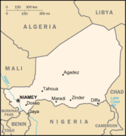
Niger , officially named the Republic of Niger, is a landlocked country in Western Africa, named after the Niger River. It borders Nigeria and Benin to the south, Burkina Faso and Mali to the west, Algeria and Libya to the north and Chad to the east...
. All larger cities are also Communes of Niger
Communes of Niger
The Departments of Niger are subdivided into communes. As of 2005, in the seven Regions and one Capital Area, there were 36 départements, divided into 265 communes, 122 cantons and 81 groupements...
. While often translated as "town", Nigerien communes are simply the third level administrative subdivision of the nation. These can be classified Urban or Rural communes, and while often the administrative unit of a town or city, all areas of the country fall within a commune. Smaller towns and neighborhoods are designated Quarters (Urban) or Villages (Rural).
Largest cities and urban centers
Cities with population over 10,000, according to 2001 census.| City | Census division | Population 2001 |
Position |
| Abalak Abalak Abalak is a town located in the Tahoua Region, Abalak Department of northern Niger. It is both a town and Commune: a local administrative division. It is the seat of Abalak Department, one of eight subdivisions of Tahoua Region... |
Tahoua | 12,764 | 15.4522222°N 6.2783333°W |
| Agadez Agadez -Sources:* Aboubacar Adamou. "Agadez et sa région. Contribution à l'étude du Sahel et du Sahara nigériens", Études nigériennes, n°44, , 358 p.* Julien Brachet. Migrations transsahariennes. Vers un désert cosmopolite et morcelé . Paris: Le Croquant, , 324 p. ISBN : 978-2-91496865-2.*. Saudi Aaramco... |
Agadez | 78,289 | 16.9738889°N 7.9908333°W |
| Aguié Aguie Aguie is a town and capital of the Aguie Department in southern Niger, 43 miles east of the nation's second largest city, Maradi.-Administrative structure:... |
Maradi | 11,475 | 13.5080556°N 7.7772222°W |
| Arlit Arlit Arlit is an industrial town and capital of the Arlit Department of the Agadez Region of northern-central Niger, built between the Sahara desert and the eastern edge of the Aïr mountains. It is 200 km south by road from the border with Algeria... |
Agadez | 69,435 | 18.7325°N 7.3680556°W |
| Birni Ngaouré | Dosso | 10,775 | 13.0877778°N 2.9169444°W |
| Birni Nkonni | Tahoua | 44,663 | 13.8°N 5.25°W |
| Dakoro Dakoro Dakoro is a town and commune located in the Maradi Region of Niger.... |
Maradi | 18,875 | 13.8166667°N 6.4166667°W |
| Diffa Diffa Diffa is a city and Urban Commune in the extreme southeast of Niger, near that country's border with Nigeria, with a population of 23,600 . It is the administrative seat of both Diffa Region, and the smaller Diffa Department... |
Diffa | 23,409 | 13.3155556°N 12.6088889°W |
| Dogondoutchi Dogondoutchi Dogondoutchi is a city located in the east of the Dosso Region of Niger. With a population of 29,244 , Dogondoutchi is the largest city in and administrative center of the Dogondoutchi department, the easternmost section of Dosso Region.... |
Dosso | 29,244 | 13.6461111°N 4.0288889°W |
| Dosso Dosso, Niger Dosso is a town in the south-west corner of Niger. It lies 130–140 km south-east of the capital Niamey at the junction of the main routes to Zinder and Benin. The seventh most populous town in Niger and the largest in Dosso Region, it had an official population during the 2001 census of 43,561... |
Dosso | 43,561 | 13.0444444°N 3.1947222°W |
| Filingué Filingue Filingue is a town in southwestern Niger and is the capital city of Filingue Department. It is near to Niger's capital city Niamey.... |
Tillabéri | 11,661 | 14.35°N 3.3166667°W |
| Gaya Gaya, Niger Gaya is a city in the Dosso Region of Niger. The city is situated 254 km southeast of the capital, Niamey, is located on the banks of the Niger River, and is near the borders with Benin and Nigeria. Gaya has a population of 28,385 . The wettest area in Niger, Gaya averages 800 mm in... |
Dosso | 28,385 | 11.8877778°N 3.4466667°W |
| Gouré Goure Goure is a town in southeastern Niger, Zinder Region, Goure Department, of which it is the seat.-Situation:Situated on the main all weather east - west highway in Southern Niger, it is about 170 km east of regional capital, Zinder, on the route east to Diffa, N'Guigmi, and the Lake Chad area... |
Zinder | 13,422 | 13.9869444°N 10.27°W |
| Guidan Roumji Guidan Roumji Guidan Roumji is a city in Maradi Region in south central Niger.... |
Maradi | 10,744 | 13.85°N 6.9666667°W |
| Illéla Illela Illela may refer to:*Illela, Nigeria, a Local Government Area in Sokoto State, Nigeria*Illela, Niger, a town and urban commune in Niger... |
Tahoua | 15,805 | 14.4616667°N 5.2475°W |
| Kollo Kollo -Sister city:-References:... |
Tillabéri | 10,533 | 13.3086111°N 2.3308333°W |
| Madaoua Madaoua Madaoua is a town located in the Tahoua Region of Niger. It has a population of 22,175 . It is seat of the Madaoua Department, forming the southwest corner of the Region, and is an Urban Commune.-References:... |
Tahoua | 22,175 | 14.1°N 6.4333333°W |
| Magaria Magaria -References:... |
Zinder | 17,776 | 14.5666667°N 8.7333333°W |
| Maïné-Soroa Maine-Soroa Maine-Soroa is a town in southeastern Niger, the capital of the Maine-soroa Department, and is in turn part of Diffa Region. Population 10,176 .-Economy:... |
Diffa | 10,176 | 13.2177778°N 12.0266667°W |
| Maradi Maradi, Niger Maradi is the third largest city in Niger and the administrative centre of Maradi Region. It is seat of the Maradi Department and an Urban Commune.-Demographics:... |
Maradi | 148,017 | 13.4916667°N 7.0963889°W |
| Matameye | Zinder | 17,930 | 13.4238889°N 8.4777778°W |
| Mirria | Zinder | 19,161 | 13.7141667°N 9.1505556°W |
| Nguigmi | Diffa | 15,922 | 14.2527778°N 13.1108333°W |
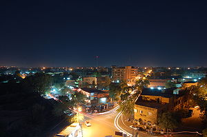
| Niamey Niamey -Population:While Niamey's population has grown steadily since independence, the droughts of the early 1970s and 1980s, along with the economic crisis of the early 1980s, have propelled an exodus of rural inhabitants to Niger's largest city... |
Niamey Capital District Niamey -Population:While Niamey's population has grown steadily since independence, the droughts of the early 1970s and 1980s, along with the economic crisis of the early 1980s, have propelled an exodus of rural inhabitants to Niger's largest city... |
707,951 | 13.5166667°N 2.1166667°W |
| Say Say, Niger Say is a town in southwest Niger, situated on the Niger River. It is the capital of the Say Department in the Tillabéri Region. The municipality has 12,000 inhabitants, and its economy is dominated by agriculture, herding and small trade.-Overview:... |
Tillabéri | 10,502 | 13.1080556°N 2.3597222°W |
| Tahoua Tahoua Tahoua is a city in Niger and the administrative center of the Department of Tahoua and the larger Tahoua Region. It has a population of 99,900 . The city is primarily a market town for the surrounding agricultural area, and a meeting place for the Tuareg people from the north and the Fulani people... |
Tahoua | 73,002 | 14.8902778°N 5.2677778°W |
| Tânout Tanout Tanout is a town in southern Niger. It is in Zinder Region, Tanout Department, north of the city of Zinder. It is the administrative capital of Tanout Department.... |
Zinder | 15,779 | 14.9702778°N 8.8916667°W |
| Tchirozérine | Agadez | 10,032 | 17.2602778°N 7.7508333°W |
| Téra Téra Téra is a town in the Tillabéri Region, Tera Department of Niger. It is situated 175 km north-west of the capital Niamey, close to the border with Burkina Faso. It is mainly inhabited by Songhai, Fulani, Gourmantche and Buzu ethnic groups. The majority of the population are farmers.- Commerce... |
Tillabéri | 19,508 | 14.0105556°N 0.7530556°W |
| Tessaoua Tessaoua Tessaoua is a city located in the Maradi Region of Niger. It has a population of 31,667 . Tessaoua is historically an important city in its region. It is situated in a central geographical location. Tessaoua is a mid-point on a historical trade route between Agadez, Niger in the north and Kano,... |
Maradi | 31,667 | 13.7533333°N 7.9863889°W |
| Tillabéri Tillabéri Tillabéri is a town in northwest Niger. It is situated 120 km northwest of the capital Niamey on the River Niger. It is an important market town and administrative center, it is capital of the department of Tillabéri and Tillabéri Region. The town had a population of over 16000 at the 2001 census... |
Tillabéri | 16,683 | 14.206146°N 1.453457°W |
| Zinder Zinder Zinder is the second largest city in Niger, with a population of 170,574 by 2005 was estimated to be over 200,000... |
Zinder | 170,575 | 13.8°N 8.9833333°W |
Agadez Region
- AderbissinatAderbissinatAderbissinat is a town and commune in central Niger. It lies in the Sahel, the semi-arid, sparsely populated zone between the Sahara Desert to the north and the millet-growing savannah to the south. Raising goats, camels, and cattle is the traditional livelihood for people in this region, which...
- AouderasAouderasAouderas is an oasis village in the Aïr Mountains of northeastern Niger, about 90km North-Northeast of the Regional capital of Agadez...
- AssamakkaAssamakkaAssamakka is small desert town in northern Niger at a main border crossing with Algeria. It is the only official crossing point between the two nations. Assamakka shares the border with the larger town of In Guezzam 10 km on the Algerian side. A main road extends north in Algeria to...
- AssodéAssodéAssodé was a town in the Aïr Mountains in what is now northern Niger. Founded around the eleventh century, it was long the most important Tuareg town, benefiting from trans-Saharan trade, and declining with it from the eighteenth century...
- BilmaBilmaBilma is an oasis town in north east Niger with a population of around 2,500 people. It lies protected from the desert dunes under the Kaouar Cliffs and is the largest town along the Kaouar escarpment...
- DabagaDabaga, NigerDabaga is a town in the Agadez Region of northern Niger. It is situated around 50 kilometers north of the regional capital, Agadez, on the main road leading north into the Air Mountains and the town of Elmeki...
- FachiFachiFachi is an oasis surrounded by the Ténéré desert and the dunes of the Erg of Bilma in eastern Niger, placed on the western edge of the small Agram mountain outcropping. It has an estimated population of some 2000 people. A stopping point of the Agadez to Kaouar caravans of the Azalay, Fachi is 150...
- IferouaneIferouaneIferouane , also spelled Iferouan, is an oasis town in northern Niger, in Agadez Department. It is located northeast of Arlit in the northern Aïr,in the Ighazar valleynear the Tamgak Range....
- In-GallIn-GallIn-Gall is a town in the Agadez Region, Tchirozerine Department of northeast Niger, with a year-round population of less than 500...
- MadamaMadamaMadama is a border settlement on the northeast frontier of Niger. Little more than an army post, the settlement serves as a frontier station controlling travel between Niger and Libya. It is also the site of a former French colonial fort.-External links :*...
- Tegguiada In TessoumTegguiada In TessoumTegguiada In Tessoum is a town in Agadez Region, Arlit Department, Niger. It's largely season population is based in the nearby town of Ingall who oversee a historic salt producing industry.-References:...
- TimiaTimiaTimia is a small town in northern Niger situated at an oasis in the Aïr Mountains, Agadez Region, Arlit Department. Visitors come to the Tuareg town to see a seasonal waterfall, a former French fort and the nearby ruined town of Assodé....
Diffa Region
- GoudoumariaGoudoumariaGoudoumaria, Niger is a town in the southeast of the country, in Diffa Region, northwest of Diffa. Goudoumaria is an administrative post in the Maine-Soroa Department, and is approx. 50km north of the Nigerian border and approx...
- BossoBosso, Niger-References:...
- ChétimariChetimari-References:...
- N'gourtiN'Gourti-References:...
- KabléwaKablewa-References:...
- Nguel beyli
- GueskérouGueskerouGueskerou is a town in southeastern Niger....
Tahoua Region
- AkoubounouAkoubounouThe village of Akoubounou, or Akabinu in the local Tin Sert language, is located in the west to the town of Abalak, in the Tahoua Region of Niger. The village is known for organizing a festival called Shiriken, which celebrates the music, culture and traditions of the Tuareg....
- BouzaBouzaBouza is a town in southwestern Niger. A town of eight thousand, it is the administrative center of Bouza Department, part of Tahoua Region.-Culture and situation:...
- DabnouDabnouDabnou is a town in southwestern Niger. It is near the city of Tahoua.It is located in the Department of Illela, in Tahoua region, municipality of Badaguichiri.It has two districts, Angoua Gabas and Angoua Yamma ....
- KorohaneKorohaneKorohane is a town in southwestern Niger. It is near the city of Tahoua....
- Malbaza UzineMalbaza UzineMalbaza Uzine is a town in southwestern Niger. It is near the city of Tahoua....
- Tchin-TabaradenTchin-TabaradenTchin-Tabaraden is a town and commune located in the Azawagh area of Niger, in the north of the Tahoua Region.It is the capital of the Region's Tchin-Tabaraden Department. It is the market center for the Iwillimidan Tuareg...
Tillabéri Region
- AyourouAyourouAyourou is a town in Tillabéri Region, in western Niger. It is situated 208 km northwest of the capital Niamey near the Malian border. The old town stands on an eponymous island in the River Niger. It is known for its animal market and for wildlife including hippopotamuses and birds....
- Bani-BangouBani-BangouBani-Bangou is a town in southwestern Niger, in rural northern Ouallam Department, Tillabéri Region. On the main highway from Ouallam on the route to the Malian border town of Andéramboukane. It is 135km northeast of Ouallam and 70km by road from Mali. It around 200 km cross country from Niamey...
- DiagorouDiagorouDiagorou is a town in southwestern Niger, Say Department, Tillaberi Region. It lies west of the Niger River, roughly halfway between the capital, Niamey, and the Nigerien border with Burkina Faso. It is within the historic Liptako region....
- KarmaKarma, NigerKarma is a town in southwestern Niger. It is near the city of Niamey....
- MatankariMatankariMatankari is a town in southwestern Niger. It is near the city of Niamey....
- OuallamOuallamOuallam is a town in southwestern Niger. It is around 300 km north of Niamey, is the capital of Ouallam Department, one of four in the Tillabery Region.-Culture:...
Zinder Region
- Cheri
- GuidimouniGuidimouniGuidimouni is a town in southern Niger. It is near the city of Zinder....
- KelakamKelakam, NigerKelakam is a town in the Diffa Region, Maine-Soroa Department of southeastern Niger.-Location:It lies on the RN1 east-west highway of which runs between Diffa and Niamey, about halfway between the larger towns of Goudoumaria to the west and Maine-Soroa to the southeast...
- Mar-JirguiMar-JirguiMar-Jirgui is a town in southern Niger. It is near the city of Zinder....
- SamiaSamia, NigerSamia is a town in southern Niger. It is near the city of Zinder....
- TakietaTakietaTakiéta is a town in south central Niger, in Mirriah Department, Zinder Region. It lies along the Route Nationale 1 , the nation's primary east-west highway, roughly halfway between Zinder and Tessaoua....