

List of cities in Ghana
Encyclopedia
This is a list of towns in Ghana
.
Ghana
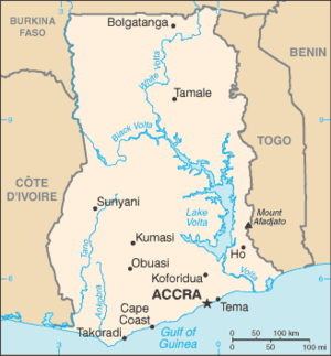
Ghana , officially the Republic of Ghana, is a country located in West Africa. It is bordered by Côte d'Ivoire to the west, Burkina Faso to the north, Togo to the east, and the Gulf of Guinea to the south...
.
| The Largest Cities in Ghana | ||||||
|---|---|---|---|---|---|---|
| Rank | City | Population | Region | |||
| Census 1 March 1970 |
Census 18 March 1984 |
Census 26 March 2000 |
Estimates 1 January 2007 |
|||
| 1. | Accra Accra Accra is the capital and largest city of Ghana, with an urban population of 1,658,937 according to the 2000 census. Accra is also the capital of the Greater Accra Region and of the Accra Metropolitan District, with which it is coterminous... |
564.194 | 867.459 | 1.659.136 | 2.096.653 | Greater Accra Greater Accra Region The Greater Accra Region is the smallest of Ghana's 10 administrative regions in terms of area, occupying a total land surface of 3,245 square kilometres or 1.4 per cent of the total land area of Ghana... |
| 2. | Kumasi Kumasi Kumasi is a city in southern central Ghana's Ashanti region. It is located near Lake Bosomtwe, in the Rain Forest Region about northwest of Accra. Kumasi is approximately north of the Equator and north of the Gulf of Guinea... |
260.286 | 489.586 1 | 1.171.311 | 1.604.909 | Ashanti Ashanti Region The Ashanti Region is the third largest of 10 administrative regions in Ghana, occupying a total land surface of 24389 square kilometers or 10.2 per cent of the total land area of Ghana. In terms of population, however, it is the most populated region with a population of 3,612,950 in 2000,... |
| 3. | Tamale | 83.653 | 135.952 | 293.879 | 390.730 | Northern Northern Region (Ghana) The Northern Region is the largest area of Ghana. As of 2009, it is divided into 20 districts. The region's capital is Tamale. Climatically, religiously, linguistically, and culturally, the region differs greatly from the politically and economically dominating regions of central and southern... |
| 4. | Sekondi-Takoradi Sekondi-Takoradi Sekondi-Takoradi, population 335,000 , comprising the twin cities of Sekondi and Takoradi, is the capital of the Western Region of Ghana. It is Ghana's fourth largest city and an industrial and commercial center. The chief industries are timber, plywood, shipbuilding and railroad repair and... |
58.161 | 61.484 | 175.438 | 260.651 | Western Western Region (Ghana) The Western Region of Ghana, reaching from the Côte d'Ivoire border in the west to the Central Region in the east, includes the large twin city of Sekondi-Takoradi on the coast, coastal Axim, and a hilly inland area including Elubo. It includes Ghana's southernmost location, Cape Three Points,... |
| 5. | Ashiaman Ashiaman Ashiaman is a city in Ghana in the Greater Accra Region. It is the fifth largest city in Ghana in terms of population, with a population of 228509.... |
22.549 | 50.918 | 150.312 | 228.509 | Greater Accra Greater Accra Region The Greater Accra Region is the smallest of Ghana's 10 administrative regions in terms of area, occupying a total land surface of 3,245 square kilometres or 1.4 per cent of the total land area of Ghana... |
| 6. | Tema Tema Tema is a city on the Atlantic coast of Ghana, lying east of the Ghanaian capital city, Accra, in the region of Greater Accra. As of 2005, Tema had a population of 209,000. The Greenwich Meridian passes directly through the city... |
60.767 | 100.052 | 141.479 | 161.106 | Greater Accra Greater Accra Region The Greater Accra Region is the smallest of Ghana's 10 administrative regions in terms of area, occupying a total land surface of 3,245 square kilometres or 1.4 per cent of the total land area of Ghana... |
| 7. | Teshie Teshie Teshie is a city in Ghana in the Greater Accra Region. Fort Augustaborg, built by the Danes in 1787, is located in Teshie and was occupied by the British from 1850 to 1957. The national Officer Cadet Training School and Kofi Annan International Peacekeeping Training Centre are also located here... |
39.382 | 59.552 | 92.359 | 154.513 | Greater Accra Greater Accra Region The Greater Accra Region is the smallest of Ghana's 10 administrative regions in terms of area, occupying a total land surface of 3,245 square kilometres or 1.4 per cent of the total land area of Ghana... |
| 8. | Cape Coast Cape Coast Cape Coast, or Cabo Corso, is the capital of the Central Region of Ghana and is also the capital city of the Fante people, or Mfantsefo. It is situated 165 km west of Accra on the Gulf of Guinea. It has a population of 82,291 . From the 16th century the city has changed hands between the... |
51.653 | 57.224 | 118.105 | 154.204 | Central Central Region (Ghana) The Central Region is one of Ghana's ten administrative regions. It is bordered by the Ashanti and Eastern regions to the north, Western region to the west, Greater Accra region to the east, and to the south by the Atlantic Ocean.-Districts:... |
| 10. | Obuasi Obuasi Obuasi is a city in southern Ghana, lying south of Kumasi. It has a population of 115,564 On the railway line from Kumasi to Sekondi, it is known for its gold mine, now one of the ten largest in the world, gold having been mined on the site since at least the seventeenth century. Tourists can... |
31.005 | 60.617 | 115.564 | 147.613 | Ashanti Ashanti Region The Ashanti Region is the third largest of 10 administrative regions in Ghana, occupying a total land surface of 24389 square kilometers or 10.2 per cent of the total land area of Ghana. In terms of population, however, it is the most populated region with a population of 3,612,950 in 2000,... |
| 11. | Madina Madina, Ghana Madina is a town in southeastern Ghana near the capital Accra. Elevation 75m. It is next to the University of Ghana and houses the Institute of Local Government. Traditionally it is under the La Stool. The land on which the town is situated belongs to the La People. According to Legend, Hausas... |
7.480 | 28.364 | 76.697 | 112.888 | Greater Accra Greater Accra Region The Greater Accra Region is the smallest of Ghana's 10 administrative regions in terms of area, occupying a total land surface of 3,245 square kilometres or 1.4 per cent of the total land area of Ghana... |
| 12. | Koforidua Koforidua Koforidua, also popularly known as Kof-town, is a city in the West African republic of Ghana, about an hour by road from Accra. It is the capital of the Eastern Region of Ghana and has a population of 87,315 .... |
46.235 | 58.731 | 87.315 | 99.890 | Eastern Eastern Region (Ghana) The Eastern Region is one of Ghana's ten administrative regions. It covers an area of 19,323 square kilometres, which is about 8.1% of Ghana's total land area. The region is divided into administrative districts. The total number of districts were increased from 17 districts to 21... |
| 13. | Wa | 13.740 | 36.067 | 66.644 | 83.091 | Upper West Upper West Region The Upper West Region of Ghana is located in the northwestern corner of the country and is bordered by Burkina Faso to the north. The capital and largest city is Wa. Other towns include Nandom, Daffiema, Jirapa, Kaleo, Nadowli, Lawra and Tumu.... |
| 14. | Techiman Techiman Techiman is the leading market town in Ghana and is, together with Sunyani, one of the two chief cities of the Brong-Ahafo Region. This city of nearly 80,000 is located at a historical crossroads of trade routes and the Tano River, and serves as capital of the Techiman Municipal... |
12.068 | 25.264 | 56.187 | 75.932 | Brong-Ahafo Brong-Ahafo Region The Brong-Ahafo Region is located in mid-western Ghana, between the Ashanti Region and the Northern Region. Its capital is Sunyani.This region was created in 1958. It contains many cultural and wildlife attractions, but it is less known to tourists than the Ashanti, Northern, Central, or Greater... |
| 15. | Nungua Nungua - Transport :It is served by a station on the eastern network of the national railway system. A bridge which was out of service for some time, was repaired in 2009... |
13.839 | 29.146 | 62.902 | 75.622 | Greater Accra Greater Accra Region The Greater Accra Region is the smallest of Ghana's 10 administrative regions in terms of area, occupying a total land surface of 3,245 square kilometres or 1.4 per cent of the total land area of Ghana... |
| 16. | Tema New Town | 13.176 | 31.466 | 58.786 | 74.874 | Greater Accra Greater Accra Region The Greater Accra Region is the smallest of Ghana's 10 administrative regions in terms of area, occupying a total land surface of 3,245 square kilometres or 1.4 per cent of the total land area of Ghana... |
| 17. | Sunyani Sunyani Sunyani is a city in the West African republic of Ghana, and is the capital of the both the Sunyani District and Brong-Ahafo Region.According to the 2005 population estimates 80,245 people reside in the city of Sunyani, with a growth rate, in the city, of 3.4% per annum.-History of... |
23.780 | 38.634 | 61.992 | 73.748 | Brong-Ahafo Brong-Ahafo Region The Brong-Ahafo Region is located in mid-western Ghana, between the Ashanti Region and the Northern Region. Its capital is Sunyani.This region was created in 1958. It contains many cultural and wildlife attractions, but it is less known to tourists than the Ashanti, Northern, Central, or Greater... |
| 18. | Ho Ho, Ghana Ho is a town in southeast Ghana and is the capital of the Volta Region. It lies between Mount Adaklu and Mount Galenukui , and is home to a museum, a cathedral and a large prison... |
24.199 | 37.777 | 61.658 | 73.498 | Volta |
| 19. | Bawku Bawku Bawku is a town in Ghana. It is the capital of the Bawku Municipal District. As of 2005, the town's population is estimated at 71,982 making it the fifteenth largest city in Ghana.-References:... |
20.567 | 34.074 | 51.379 | 59.055 | Upper East Upper East Region The Upper East Region is the smallest of 10 administrative regions in Ghana, occupying a total land surface of 8,842 square kilometers or 2.7 per cent of the total land area of Ghana. In terms of population, it is the ninth most populated region with a population of 920,089 in 2000, accounting for... |
| 20. | Dome Dome, Ghana Dome is a town in the Greater Accra Region of Ghana. As of 2007, the town's population is estimated at 56,655 making it the twentieth largest city in Ghana.-References:... |
772 | 1.954 | 29.618 | 56.655 | Greater Accra Greater Accra Region The Greater Accra Region is the smallest of Ghana's 10 administrative regions in terms of area, occupying a total land surface of 3,245 square kilometres or 1.4 per cent of the total land area of Ghana... |
| 21. | Bolgatanga Bolgatanga Bolgatanga, colloquially known as Bolga, is the capital of both the Bolgatanga Municipal District and the Upper East Region of Ghana, and has a population of about 72,000... |
18.896 | 32.495 | 49.162 | 56.583 | Upper East Upper East Region The Upper East Region is the smallest of 10 administrative regions in Ghana, occupying a total land surface of 8,842 square kilometers or 2.7 per cent of the total land area of Ghana. In terms of population, it is the ninth most populated region with a population of 920,089 in 2000, accounting for... |
| 22. | Lashibi | k.A. | 507 | 30.193 | 54.789 | Greater Accra Greater Accra Region The Greater Accra Region is the smallest of Ghana's 10 administrative regions in terms of area, occupying a total land surface of 3,245 square kilometres or 1.4 per cent of the total land area of Ghana... |
| 23. | Tafo | k.A. | 25.688 | k.A. | 53.165 | Ashanti Ashanti Region The Ashanti Region is the third largest of 10 administrative regions in Ghana, occupying a total land surface of 24389 square kilometers or 10.2 per cent of the total land area of Ghana. In terms of population, however, it is the most populated region with a population of 3,612,950 in 2000,... |
| 24. | Gbawe | 608 | 837 | 28.989 | 52.910 | Greater Accra Greater Accra Region The Greater Accra Region is the smallest of Ghana's 10 administrative regions in terms of area, occupying a total land surface of 3,245 square kilometres or 1.4 per cent of the total land area of Ghana... |
| 25. | Agona Swedru | 21.522 | 31.226 | 45.614 | 52.161 | Central Central Region (Ghana) The Central Region is one of Ghana's ten administrative regions. It is bordered by the Ashanti and Eastern regions to the north, Western region to the west, Greater Accra region to the east, and to the south by the Atlantic Ocean.-Districts:... |
| 26. | Ejura Ejura Ejura is the largest maize producing district in the Ashanti Region of Ghana. It is in the far north of the region, near the Afram River. Ejura is connected by highways with the towns of Mampong, Yeji and Techiman. It is home to the Digya National Park / Kujani Game Reserve.It is also the location... |
10.664 | 18.775 | 29.478 | 49.954 | Ashanti Ashanti Region The Ashanti Region is the third largest of 10 administrative regions in Ghana, occupying a total land surface of 24389 square kilometers or 10.2 per cent of the total land area of Ghana. In terms of population, however, it is the most populated region with a population of 3,612,950 in 2000,... |
| 27. | Berekum Berekum Berekum is a town in Ghana. It is the capital of Berekum District.The footballer John Paintsil , who plays for the English Championship side Leicester City, was born here.... |
14.296 | 22.264 | 39.649 | 49.149 | Brong-Ahafo Brong-Ahafo Region The Brong-Ahafo Region is located in mid-western Ghana, between the Ashanti Region and the Northern Region. Its capital is Sunyani.This region was created in 1958. It contains many cultural and wildlife attractions, but it is less known to tourists than the Ashanti, Northern, Central, or Greater... |
| 28. | Taifa | k.A. | 1.009 | 26.145 | 48.927 | Greater Accra Greater Accra Region The Greater Accra Region is the smallest of Ghana's 10 administrative regions in terms of area, occupying a total land surface of 3,245 square kilometres or 1.4 per cent of the total land area of Ghana... |
| 29. | Aflao Aflao Aflao is a city on Ghana's Togolese border. It is primarily populated by the Anlo people, a branch of the Ewe people.In the 18th century, Aflao served as one of the major markets for the slave trade.- References :* Dickson, K. B... |
1.397 | 20.904 | 38.927 | 48.876 | Volta |
| 30. | Nkawkaw Nkawkaw Nkawkaw is an important town in the Kwahu West District of the Eastern Region of Ghana, with an estimated population in 2010 at 53,520. The town is inhabited by the Obomeng and Atibie ethnic groups.... |
23.219 | 31.785 | 43.703 | 48.503 | Eastern Eastern Region (Ghana) The Eastern Region is one of Ghana's ten administrative regions. It covers an area of 19,323 square kilometres, which is about 8.1% of Ghana's total land area. The region is divided into administrative districts. The total number of districts were increased from 17 districts to 21... |
| 31. | Oduponkpehe | 863 | 2.597 | 34.719 | 48.228 | Central Central Region (Ghana) The Central Region is one of Ghana's ten administrative regions. It is bordered by the Ashanti and Eastern regions to the north, Western region to the west, Greater Accra region to the east, and to the south by the Atlantic Ocean.-Districts:... |
| 32. | Winneba Winneba Winneba, traditionally known as Simpa, also known as the Land of the Gharteys because its royals and many of its inhabitants bear this name,... |
30.778 | 27.105 | 40.017 | 45.954 | Central Central Region (Ghana) The Central Region is one of Ghana's ten administrative regions. It is bordered by the Ashanti and Eastern regions to the north, Western region to the west, Greater Accra region to the east, and to the south by the Atlantic Ocean.-Districts:... |
| 33. | Akim Oda Akim Oda Akim Oda or Akyem Oda is a town in the Eastern Region of Ghana with a population of about 38,000 people. It is the capital of the Birim Central Municipal district... |
20.957 | 24.629 | 38.741 | 45.332 | Eastern Eastern Region (Ghana) The Eastern Region is one of Ghana's ten administrative regions. It covers an area of 19,323 square kilometres, which is about 8.1% of Ghana's total land area. The region is divided into administrative districts. The total number of districts were increased from 17 districts to 21... |
| 34. | Yendi Yendi Yendi is a town in the northeastern quadrant of Ghana in the Dagbon territory. As of 2000, it has a population of 40,336 people. Yendi is the traditional capital of the Dagbon Kingdom with the Ya Na as the Overlord. The people of Dagbon are called Dagombas or Dagbamba... |
22.072 | 31.633 | 40.336 | 43.908 | Northern Northern Region (Ghana) The Northern Region is the largest area of Ghana. As of 2009, it is divided into 20 districts. The region's capital is Tamale. Climatically, religiously, linguistically, and culturally, the region differs greatly from the politically and economically dominating regions of central and southern... |
| 35. | Hohoe Hohoe Hohoe is a town in the mountainous Hohoe Municipality of the Volta Region of Ghana, with its beautiful climate and many tourist attractions like the Wli Waterfalls. It is between Lake Volta and the border of Togo. Hohoe is connected by road to Kpandu and Ho in Ghana; and Kpalimé and Badou in Togo.... |
14.775 | 20.994 | 35.277 | 42.550 | Volta |
| 36. | Adenta East | k.A. | k.A. | 31.070 | 39.730 | Greater Accra Greater Accra Region The Greater Accra Region is the smallest of Ghana's 10 administrative regions in terms of area, occupying a total land surface of 3,245 square kilometres or 1.4 per cent of the total land area of Ghana... |
| 37. | Mampong Mampong Mampong is a town in Ghana. It is found in the Ashanti Region in Ghana, and serves as the administrative capital of Sekyere West District.It is also the home of the Mampong Centre for Scientific Research into Plant Medicine. The center conducts research in the use of plant medicine in the cure of... |
13.895 | 20.228 | 31.740 | 37.575 | Ashanti Ashanti Region The Ashanti Region is the third largest of 10 administrative regions in Ghana, occupying a total land surface of 24389 square kilometers or 10.2 per cent of the total land area of Ghana. In terms of population, however, it is the most populated region with a population of 3,612,950 in 2000,... |
| 38. | Asamankese Asamankese Asmankese is a town situated in the Eastern Region of Ghana. It has a population of approximately 34,000 people. It is on the main highway between the two biggest cities of Accra on the coast and Kumasi in the interior. It is the second capital town of the Eastern Region and it is the capital town... |
16.905 | 23.077 | 34.855 | 37.349 | Eastern Eastern Region (Ghana) The Eastern Region is one of Ghana's ten administrative regions. It covers an area of 19,323 square kilometres, which is about 8.1% of Ghana's total land area. The region is divided into administrative districts. The total number of districts were increased from 17 districts to 21... |
| 39. | Kintampo Kintampo The Kintampo archeological site in Ghana dates back to 2500-1400 BCE and is one of the earliest known sites for the cultivation of the cowpea. Evidence of polished stone axes, stone beads, buildings of stone, domestic pots, ceramic sculptures of humans and animals indicate that Kintampo was... |
7.149 | 13.943 | 28.276 | 36.890 | Brong-Ahafo Brong-Ahafo Region The Brong-Ahafo Region is located in mid-western Ghana, between the Ashanti Region and the Northern Region. Its capital is Sunyani.This region was created in 1958. It contains many cultural and wildlife attractions, but it is less known to tourists than the Ashanti, Northern, Central, or Greater... |
| 40. | Suhum | 12.421 | 19.298 | 31.044 | 36.650 | Eastern Eastern Region (Ghana) The Eastern Region is one of Ghana's ten administrative regions. It covers an area of 19,323 square kilometres, which is about 8.1% of Ghana's total land area. The region is divided into administrative districts. The total number of districts were increased from 17 districts to 21... |
| 41. | Tarkwa | 4.702 | 22.107 | 30.631 | 34.544 | Western Western Region (Ghana) The Western Region of Ghana, reaching from the Côte d'Ivoire border in the west to the Central Region in the east, includes the large twin city of Sekondi-Takoradi on the coast, coastal Axim, and a hilly inland area including Elubo. It includes Ghana's southernmost location, Cape Three Points,... |
| 42. | Konongo Konongo The Konongo are an ethnic and linguistic group based in the Mpanda District of Rukwa Region in western Tanzania. In 1987 the Konongo population was estimated to number 51,000 .... |
10.881 | 13.677 | 26.735 | 34.509 | Ashanti Ashanti Region The Ashanti Region is the third largest of 10 administrative regions in Ghana, occupying a total land surface of 24389 square kilometers or 10.2 per cent of the total land area of Ghana. In terms of population, however, it is the most populated region with a population of 3,612,950 in 2000,... |
| 43. | Nsawam Nsawam Nsawam is a town in the Eastern Region of Ghana approximately 40 km northwest from the capital, Accra. It is controlled by the Akwapim Society.... |
25.518 | 20.439 | 29.986 | 34.142 | Eastern Eastern Region (Ghana) The Eastern Region is one of Ghana's ten administrative regions. It covers an area of 19,323 square kilometres, which is about 8.1% of Ghana's total land area. The region is divided into administrative districts. The total number of districts were increased from 17 districts to 21... |
| 44. | Prestea Prestea Prestea is a town in southwest Ghana. It lies on the west bank of the Ankobra River, about 60 mi northwest of Cape coast.- Transport :It is the terminus of a railway branchline linked with Tarkwa and Sekondi-Takoradi.- External links :... |
5.143 | 16.922 | 21.844 | 33.170 | Western Western Region (Ghana) The Western Region of Ghana, reaching from the Côte d'Ivoire border in the west to the Central Region in the east, includes the large twin city of Sekondi-Takoradi on the coast, coastal Axim, and a hilly inland area including Elubo. It includes Ghana's southernmost location, Cape Three Points,... |
| 45. | Agogo | 14.710 | 18.879 | 28.271 | 32.859 | Ashanti Ashanti Region The Ashanti Region is the third largest of 10 administrative regions in Ghana, occupying a total land surface of 24389 square kilometers or 10.2 per cent of the total land area of Ghana. In terms of population, however, it is the most populated region with a population of 3,612,950 in 2000,... |
| 46. | Wenchi Wenchi Wenchi is a town in Ghana located at 7.73333 [latitude in decimal degrees], -2.1 [longitude in decimal degrees] at an elevation/altitude of meters. The average elevation of Wenchi, Ghana is 304 meters. The town is approximately 30 km north of Techiman on the Wa road and about 50 km east... |
13.836 | 18.583 | 28.141 | 32.735 | Brong-Ahafo Brong-Ahafo Region The Brong-Ahafo Region is located in mid-western Ghana, between the Ashanti Region and the Northern Region. Its capital is Sunyani.This region was created in 1958. It contains many cultural and wildlife attractions, but it is less known to tourists than the Ashanti, Northern, Central, or Greater... |
| 47. | Effiakuma Effiakuma Effiakuma is a residential town in the Western region of Ghana. It is about 10 kilometres from Takoradi the regional capital. It was built in the early 1960s by the then president of the country Kwame Nkrumah. There are about three general plans for the buildings in the area. The houses were built... |
k.A. | 31.876 | Western Western Region (Ghana) The Western Region of Ghana, reaching from the Côte d'Ivoire border in the west to the Central Region in the east, includes the large twin city of Sekondi-Takoradi on the coast, coastal Axim, and a hilly inland area including Elubo. It includes Ghana's southernmost location, Cape Three Points,... |
||
| 48. | Anloga Anloga Anloga is a town in Keta District of the Volta Region in southeast Ghana, West Africa. It lies east of the Volta River and just south of the Keta Lagoon.-History:... |
14.032 | 18.993 | 20.886 | 30.857 | Volta |
| 49. | Savelugu | 9.895 | 16.965 | 24.937 | 30.529 | Northern Northern Region (Ghana) The Northern Region is the largest area of Ghana. As of 2009, it is divided into 20 districts. The region's capital is Tamale. Climatically, religiously, linguistically, and culturally, the region differs greatly from the politically and economically dominating regions of central and southern... |