
Upper East Region
Encyclopedia
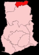
The Upper East Region is the smallest of 10 administrative regions in Ghana, occupying a total land surface of 8,842 square kilometers or 2.7 per cent of the total land area of Ghana. In terms of population, it is the ninth most populated region with a population of 920,089 in 2000, accounting for 4.9 per cent of Ghana’s total population. The regional capital is Bolgatanga
, sometimes referred to as Bolga. Other major cities are Bawku
and Navrongo
.
to the north and Togo
to the east. It lies between longitude 00 and 10 West, and latitudes 100 30”N and 110N. The region shares boundaries with Burkina Faso
to the north, Togo
to the east, Upper West Region
to the west, and the Northern Region to the south. The region is divided into 9 districts, each headed by a district chief executive.
of the Upper East Region is located in its capital city of Bolgatanga
. According to the 2000 census, the region had a population of 920, 089 making it the ninth most populous region.
The population is primarily rural (84.3%) and scattered in dispersed settlements. There are generally no distinct boundaries between communities as compounds in contiguous villages over lap. The rural population in 1984 was 87.1 percent. There was, thus, a 2.8 percentage point reduction in the rural share of the population between 1984 and 2000 .
With only 15.7 per cent of the population living in urban areas, the region is the least urbanized in the country. In fact, together with Upper West, they are the two regions with a less than 20 per cent urban population.
Ghanaians by birth or parenthood constitute 92.5 per cent of the population of the region. Naturalized Ghanaians constitute 5.3 per cent and the rest are non-Ghanaians.
The main ethnic groups in the region are the Nabdam (30.5%), Kusasi (22.6%), Nankani & Kassena (15.7%), Builsa (7.6%), Busanga (6%) and Mamprusi (1.8%) .
– N2, N10, and N11 – and a few Regional highways such as the R113, R114, R116 and R181, serve the region.
The N10
originates from Yemoransa in the Central Region
and connects through Kumasi
in the Ashanti Region
and terminates at Paga in the Upper East Region. The national capital of Accra
is also connected to the region by the N2
which terminates in Kulungugu in the Upper East Region. Both these national routes are connected by the N11
which links the regional capital of Bolgatanga
to Bimpiela, also in the region.

Bolgatanga
Bolgatanga, colloquially known as Bolga, is the capital of both the Bolgatanga Municipal District and the Upper East Region of Ghana, and has a population of about 72,000...
, sometimes referred to as Bolga. Other major cities are Bawku
Bawku
Bawku is a town in Ghana. It is the capital of the Bawku Municipal District. As of 2005, the town's population is estimated at 71,982 making it the fifteenth largest city in Ghana.-References:...
and Navrongo
Navrongo
Navrongo is in Ghana, near its northern border. It is the capital of Kassena-Nankana District – which is within the Upper East Region of Ghana.Navrongo is an important market town, known for its cathedral and its grotto....
.
Location and size
The Upper East region is located in the north-eastern corner of Ghana and bordered by Burkina FasoBurkina Faso
Burkina Faso – also known by its short-form name Burkina – is a landlocked country in west Africa. It is surrounded by six countries: Mali to the north, Niger to the east, Benin to the southeast, Togo and Ghana to the south, and Côte d'Ivoire to the southwest.Its size is with an estimated...
to the north and Togo
Togo
Togo, officially the Togolese Republic , is a country in West Africa bordered by Ghana to the west, Benin to the east and Burkina Faso to the north. It extends south to the Gulf of Guinea, on which the capital Lomé is located. Togo covers an area of approximately with a population of approximately...
to the east. It lies between longitude 00 and 10 West, and latitudes 100 30”N and 110N. The region shares boundaries with Burkina Faso
Burkina Faso
Burkina Faso – also known by its short-form name Burkina – is a landlocked country in west Africa. It is surrounded by six countries: Mali to the north, Niger to the east, Benin to the southeast, Togo and Ghana to the south, and Côte d'Ivoire to the southwest.Its size is with an estimated...
to the north, Togo
Togo
Togo, officially the Togolese Republic , is a country in West Africa bordered by Ghana to the west, Benin to the east and Burkina Faso to the north. It extends south to the Gulf of Guinea, on which the capital Lomé is located. Togo covers an area of approximately with a population of approximately...
to the east, Upper West Region
Upper West Region
The Upper West Region of Ghana is located in the northwestern corner of the country and is bordered by Burkina Faso to the north. The capital and largest city is Wa. Other towns include Nandom, Daffiema, Jirapa, Kaleo, Nadowli, Lawra and Tumu....
to the west, and the Northern Region to the south. The region is divided into 9 districts, each headed by a district chief executive.
Parks
- Paga crocodile pond
- Gbelle game reserve
- Sombo Bat Sanctuary
- Jafiiri Sacred Royal Python Sanctuary
Festivals
The region plays host to many festivals throughout the year, most of which are either to bring a good planting season or celebrate the harvest.- Gologo Festival
- Fao Festival
- Paragbiele Festival
- Willa Festival
- Zumbenti Festival
- Kobina Festival
- Kakube Festival
Population
The center of populationCenter of population
In demographics, the center of population of a region is a geographical point that describes a centerpoint of the region's population...
of the Upper East Region is located in its capital city of Bolgatanga
Bolgatanga
Bolgatanga, colloquially known as Bolga, is the capital of both the Bolgatanga Municipal District and the Upper East Region of Ghana, and has a population of about 72,000...
. According to the 2000 census, the region had a population of 920, 089 making it the ninth most populous region.
The population is primarily rural (84.3%) and scattered in dispersed settlements. There are generally no distinct boundaries between communities as compounds in contiguous villages over lap. The rural population in 1984 was 87.1 percent. There was, thus, a 2.8 percentage point reduction in the rural share of the population between 1984 and 2000 .
With only 15.7 per cent of the population living in urban areas, the region is the least urbanized in the country. In fact, together with Upper West, they are the two regions with a less than 20 per cent urban population.
Ghanaians by birth or parenthood constitute 92.5 per cent of the population of the region. Naturalized Ghanaians constitute 5.3 per cent and the rest are non-Ghanaians.
The main ethnic groups in the region are the Nabdam (30.5%), Kusasi (22.6%), Nankani & Kassena (15.7%), Builsa (7.6%), Busanga (6%) and Mamprusi (1.8%) .
Religion
The religious affiliations of the people of the Upper East region are:- Traditional - 46.4%
- IslamIslamIslam . The most common are and . : Arabic pronunciation varies regionally. The first vowel ranges from ~~. The second vowel ranges from ~~~...
- 22.6% - ChristianChristianityChristianity is a monotheistic religion based on the life and teachings of Jesus as presented in canonical gospels and other New Testament writings...
– 28.3%
Transportation
Three National highwaysGhana road network
The Ghana Road Network is maintained by the Ghana Highway Authority, which was established in 1974 to develop the country's trunk road network totaling 13,367 km. This makes up 33% of Ghana's total road network of 40,186 km...
– N2, N10, and N11 – and a few Regional highways such as the R113, R114, R116 and R181, serve the region.
The N10
Ghana road network
The Ghana Road Network is maintained by the Ghana Highway Authority, which was established in 1974 to develop the country's trunk road network totaling 13,367 km. This makes up 33% of Ghana's total road network of 40,186 km...
originates from Yemoransa in the Central Region
Central Region (Ghana)
The Central Region is one of Ghana's ten administrative regions. It is bordered by the Ashanti and Eastern regions to the north, Western region to the west, Greater Accra region to the east, and to the south by the Atlantic Ocean.-Districts:...
and connects through Kumasi
Kumasi
Kumasi is a city in southern central Ghana's Ashanti region. It is located near Lake Bosomtwe, in the Rain Forest Region about northwest of Accra. Kumasi is approximately north of the Equator and north of the Gulf of Guinea...
in the Ashanti Region
Ashanti Region
The Ashanti Region is the third largest of 10 administrative regions in Ghana, occupying a total land surface of 24389 square kilometers or 10.2 per cent of the total land area of Ghana. In terms of population, however, it is the most populated region with a population of 3,612,950 in 2000,...
and terminates at Paga in the Upper East Region. The national capital of Accra
Accra
Accra is the capital and largest city of Ghana, with an urban population of 1,658,937 according to the 2000 census. Accra is also the capital of the Greater Accra Region and of the Accra Metropolitan District, with which it is coterminous...
is also connected to the region by the N2
Ghana road network
The Ghana Road Network is maintained by the Ghana Highway Authority, which was established in 1974 to develop the country's trunk road network totaling 13,367 km. This makes up 33% of Ghana's total road network of 40,186 km...
which terminates in Kulungugu in the Upper East Region. Both these national routes are connected by the N11
Ghana road network
The Ghana Road Network is maintained by the Ghana Highway Authority, which was established in 1974 to develop the country's trunk road network totaling 13,367 km. This makes up 33% of Ghana's total road network of 40,186 km...
which links the regional capital of Bolgatanga
Bolgatanga
Bolgatanga, colloquially known as Bolga, is the capital of both the Bolgatanga Municipal District and the Upper East Region of Ghana, and has a population of about 72,000...
to Bimpiela, also in the region.
Districts
The political administration of the region is through the local government system. Under this administration system, the region is divided into 9 districts. Each District, Municipal or Metropolitan Area, is administered by a Chief Executive, representing the central government but deriving authority from an Assembly headed by a presiding member elected from among the members themselves.| Districts in Upper East Region Region | |
|---|---|
| District | Capital |
| Bawku Municipal Bawku Municipal District The Bawku Municipal District is one of the eight districts in the Upper East Region of Ghana. The district borders Burkina Faso and Togo.Kusasi, Mamprussi, Bissa and Mossi are the main ethnic groups living in Bawku District, with the Kusasi forming the majority of the population, followed by Bissa.... |
Bawku |
| Bawku West | Zebila |
| Bolgatanga Municipal | Bolgatanga Bolgatanga Bolgatanga, colloquially known as Bolga, is the capital of both the Bolgatanga Municipal District and the Upper East Region of Ghana, and has a population of about 72,000... |
| Bongo | Bongo |
| Builsa | Sandema |
| Garu-Tempane | Garu |
| Kassena Nankana East | Navrongo |
| Kassena Nankana West | Paga |
| Talensi-Nabdam | Tongo |