

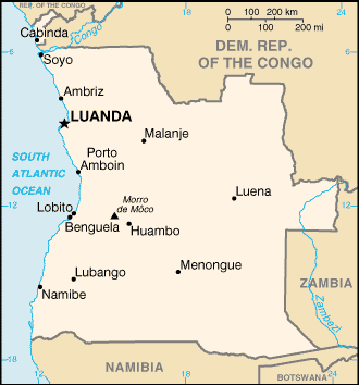
List of cities and towns in Angola
Encyclopedia
This is a list of cities and towns in Angola
Angola
Angola, officially the Republic of Angola , is a country in south-central Africa bordered by Namibia on the south, the Democratic Republic of the Congo on the north, and Zambia on the east; its west coast is on the Atlantic Ocean with Luanda as its capital city...
| Name of town or city | Coordinates Geographic coordinate system A geographic coordinate system is a coordinate system that enables every location on the Earth to be specified by a set of numbers. The coordinates are often chosen such that one of the numbers represent vertical position, and two or three of the numbers represent horizontal position... | |Province Provinces of Angola Angola is divided into eighteen provinces:-See also:* ISO 3166-2:AO, the ISO codes for Angola.... |
|
|---|---|---|---|
| Ambriz Ambriz Ambriz is a city, commune and municipality in Bengo Province, Angola.The population of Ambriz is majority Bakongo, with some Portuguese descedents.Also, the population also includes Ovimbundu and Kimbundu.... |
7.86°N 13.12°W | Bengo | |
| Andulo Andulo Andulo is a town and municipality in Bié Province in Angola.The municipality covers an area of 10, 316 km ², with about 319, 000 inhabitants. It is bordered to the north by the municipality of Mussende, to the east by the municipalities of Luquembo and Nharea, to the south by the municipalities of... |
11.48°N 16.69°W | Bié | |
| Bailundo Bailundo Bailundo is a municipality and town in Huambo Province in the central highlands of Angola.In the 1990s, Bailundo was the location of the headquarters of UNITA leader Jonas Savimbi.... |
12.19°N 15.86°W | Huambo | |
| Balombo Balombo Balombo is a town and municipality in Benguela Province in Angola.... |
12.36°N 14.77°W | Benguela | |
| Baía Farta | 12.61°N 13.19°W | Benguela | |
| Benguela Benguela Benguela is a city in western Angola, south of Luanda, and capital of Benguela Province. It lies on a bay of the same name, in 12° 33’ S., 13° 25’ E... (Benguella) |
12.58°N 13.40°W | Benguela | |
| Bibala Bibala - References :... |
14.76°N 13.35°W | Namibe | |
| Bimbe | 11.82°N 15.82°W | Huambo | |
| Biula | 11.18°N 20.22°W | Lunda Sul | |
| Bungo | 7.44°N 15.39°W | Uíge | |
| Cabamba | 8.35°N 17.51°W | Malanje | |
| Cabinda Cabinda (city) Cabinda or Tchiowa, as it is called by the Cabindans, is a city that is located in the Cabinda Province, an exclave of Angola. Angolan sovereignty over Cabinda is disputed by the Republic of Cabinda... (Kabinda) |
5.56°N 12.19°W | Cabinda | |
| Caboledo | 9.66°N 13.24°W | Bengo | |
| Cacolo Cacolo Cacolo is a town and municipality in Lunda Sul Province in Angola.... |
10.15°N 19.26°W | Lunda Sul | |
| Caconda Caconda Caconda is a municipality and city situated in the North of the province of Huila, Angola, in the Plano Alto region, approximately 280 km North of Lubango, the provincial capital city, and approximately 700 km South from Luanda, the country's capital city. The Concelho was officially founded on... |
13.73°N 15.06°W | Huíla | |
| Caculama | 9.48°N 16.85°W | Malanje | |
| Cacuso | 9.43°N 15.74°W | Malanje | |
| Cafunfo Cafunfo Cafunfo is a village in North-Eastern Angola dominated by the informal and formal diamond mining industries. The area has numerous alluvial diamond deposits.... |
8.77°N 18.00°W | Lunda Norte | |
| Cahama Cahama Cahama is a city of Cunene Province, Angola. The population is about 52,000.There is an airport to the north of the city.... |
16.29°N 14.30°W | Cunene | |
| Caiengue | 12.43°N 15.71°W | Huambo | |
| Caimbambo Caimbambo Caimbambo is a town and municipality in Benguela Province in Angola.... |
13.03°N 14.01°W | Benguela | |
| Calandala | 9.21°N 17.98°W | Lunda Norte | |
| Calenga (Kalenga) | 12.85°N 15.47°W | Huambo | |
| Calonda | 8.47°N 20.55°W | Lunda Norte | |
| Calucinga | 11.32°N 16.20°W | Bié | |
| Calulo | 10.00°N 14.90°W | Cuanza Sul | |
| Caluquembe Caluquembe Caluquembe is a town and municipality in Huíla Province, Angola. It is also the site of two missionary efforts; one, Roman Catholic and the other, Evangelical Protestant... (Kalukembe) |
13.78°N 14.78°W | Huíla | |
| Camabatela | 8.19°N 15.37°W | Cuanza Norte | |
| Camacupa Camacupa Camacupa is a town and municipality in Bié Province in Angola.It lies on the Central Railway of Angola which heads inland from the port of Benguela.- External links :*... (General Machado, Vila General Machado) |
12.02°N 17.47°W | Bié | |
| Camanongue Camanongue Camanongue is a city in the Moxico province in eastern Angola. The city has about 43,780 inhabitants and is about 24 km² in total area.... (Buçaco, Kamenongue) |
11.44°N 20.16°W | Moxico | |
| Camaxilo | 8.34°N 18.91°W | Lunda Norte | |
| Cambambe Cambambe Cambambe is a town and municipality in Cuanza Norte Province in Angola. It is the site of a hydroelectric dam on the Cuanza River. Cambambe also contains ruins from the 17th century Portuguese settlement of the area, including the Igreja da Nossa Senhora do Rosário.... |
8.37°N 17.67°W | Lunda Norte | |
| Cambongue | 15.15°N 12.17°W | Namibe | |
| Cambundi (Nova Gaia, Catembo) | 10.08°N 17.55°W | Malanje | |
| Camissombo (Veríssimo Sarmento) | 8.16°N 20.66°W | Lunda Norte | |
| Candjimbe | 12.27°N 15.23°W | Huambo | |
| Cangamba (Vila de Aljustrel) | 13.70°N 19.86°W | Moxico | |
| Cangandala Cangandala Cangandala is a município in the province of Malanje in Angola. It covers an area of and its estimated population as of 2006 is 32,236 inhabitants.... |
9.79°N 16.43°W | Malanje | |
| Cangumbe | 11.96°N 19.20°W | Moxico | |
| Capelongo (Cubango, Kuvango) | 14.47°N 16.29°W | Huíla | |
| Capenda Camulemba | 9.42°N 18.43°W | Lunda Norte | |
| Capulo | 7.95°N 13.17°W | Bengo | |
| Cassanguide (Cassanguidi) | 7.49°N 21.30°W | Lunda Norte | |
| Cassongue Cassongue Cassongue is a town and municipality in Cuanza Sul Province in Angola.... |
11.85°N 15.05°W | Cuanza Sul | |
| Catabola Catabola Catabola is a town and municipality in Bié Province in Angola.... (Katabola, Chissamba, Nova Sintra) |
12.15°N 17.28°W | Bié | |
| Catacanha | 8.06°N 13.23°W | Bengo | |
| Catchiungo (Katchiungo, Katchungo, Cantchiungo) | 12.56°N 16.22°W | Huambo | |
| Catumbela Catumbela Catumbela is a city and a municipality of the Benguela province in Angola.- Transport :Catumbela is served by a station on the national railway network as well as an airstrip.... |
12.43°N 13.55°W | Benguela | |
| Caungula Caungula Caungula is a town and municipality in Lunda Norte Province in Angola.... |
8.08°N 19.08°W | Lunda Norte | |
| Caxita Cameia | 8.42°N 17.45°W | Malanje | |
| Caxito Caxito Caxito is a town and commune and capital of Bengo Province, Angola.The northern line of Angolan Railways passes through.... |
8.58°N 13.66°W | Bengo | |
| Cazaje (Cazage) | 11.07°N 20.71°W | Lunda Sul | |
| Cazombo | 11.89°N 22.90°W | Moxico | |
| Caála Caála Caála is a town located in Huambo Province in Angola. It was known as Robert Williams town while Angola was a Portuguese colony, after the famous railroad developer and mining magnate, Sir Robert Williams. The town's last known population count was 22,010.... (Kaala, Kahala, Robert Williams, Vila Robert Williams) |
12.85°N 15.56°W | Huambo | |
| Cela Cela, Angola Cela is a município in the province of Cuanza Sul in Angola. It covers an area of and its estimated population as of 2006 is 147,896 inhabitants.... |
11.42°N 15.12°W | Cuanza Sul | |
| Chiange Chiange Chiange is a town and municipality in Huíla Province in Angola.It is terminus of a branch of the southern railway network, junctioning at Dongo.... |
15.74°N 13.89°W | Huíla | |
| Chibanda | 12.16°N 16.75°W | Bié | |
| Chibemba | 15.75°N 14.08°W | Huíla | |
| Chibia Chibia Chibia is a town and municipality in Huíla Province in Angola.It is served by a station on the southern network of the national railway network.... |
15.19°N 13.69°W | Huíla | |
| Chicala | 11.94°N 19.63°W | Moxico | |
| Chingufo | 7.62°N 20.53°W | Lunda Norte | |
| Chipindo Chipindo Chipindo is a town and municipality in Huíla Province in Angola., situated 450 km North of Lubango, Huila province capital.- Geography & Territory :... |
13.83°N 15.80°W | Huíla | |
| Chissamba Chissamba Chissamba is a town located in the province of Bié in Angola. It was also the site of a prominent mission hospital and a Bible School. The hospital and School were destroyed during the recently ended civil war. There have been some efforts to rebuild.... |
Bié | ||
| Chitado | 17.32°N 13.92°W | Cunene | |
| Chitembo Chitembo Chitembo is a town and municipality in Bié Province in Angola.... |
13.52°N 16.75°W | Bié | |
| Coemba | 12.15°N 18.09°W | Bié | |
| Colui (Candingo) | 14.52°N 16.00°W | Huíla | |
| Conda Conda Conda is a town and municipality in Cuanza Sul Province in Angola.... |
11.11°N 14.34°W | Cuanza Sul | |
| Cota | 9.27°N 16.10°W | Malanje | |
| Coutada | 17.02°N 21.30°W | ||
| Cuangar Cuangar Cuangar is a town and municipality in Cuando Cubango Province in Angola. The town lies on the Okavango River, opposite the town of Nkurenkuru, Namibia.... |
17.61°N 18.62°W | Cuando Cubango | |
| Cuango-Luzamba (Kwango, Luzamba, Cuango) | 9.12°N 18.04°W | Lunda Norte | |
| Cuasa | 11.35°N 21.82°W | Moxico | |
| Cubal Cubal Cubal is a town and municipality in Benguela Province in Angola.- External links :*... |
13.04°N 14.24°W | Benguela | |
| Cuchi Cuchi Cuchi is a town and municipality in Cuando Cubango Province in Angola.-Transport:It is served by a station on the southern main line of South Angolan Railways.-External links:*... |
14.66°N 16.89°W | Cuando Cubango | |
| Cuilo Cuilo Cuilo is a town and municipality in Lunda Norte Province in Angola.... |
8.24°N 19.52°W | Lunda Norte | |
| Cuima Cuima - Transport :It is the terminus of a branch railway that junctions of the Benguela Railway near Pais.... |
13.24°N 15.64°W | Huambo | |
| Cuimba Cuimba Cuimba is a town and municipality in Zaire Province in Angola.... |
6.12°N 14.62°W | Zaire | |
| Cuito Canavale | 15.16°N 19.17°W | Cuando Cubango | |
| Cuvelai | 15.66°N 15.80°W | Cunene | |
| Dala Dala, Angola Dala is a town and municipality in Lunda Sul Province in Angola.... |
11.03°N 20.20°W | Lunda Sul | |
| Damba | 6.68°N 15.13°W | Uíge | |
| Didimbo Didimbo Didimbo is a town in south-east Angola.... |
17°30′S 21°45′E | ||
| Dombe Grande | 12.95°N 13.10°W | Benguela | |
| Dondo Dondo, Angola Dondo is a town in northern Angola. It belongs to Cuanza Norte Province.- Namesakes :There are several towns with this name. This is the one which is a branch terminus on the northern Luanda Railways. The namesakes are in Huila Province, Uíge Province and Huambo Province.- Map :* - External links... |
9.69°N 14.43°W | Cuanza Norte | |
| Dongo Dongo, Huila, Angola Dongo is a town in southern Angola. It lies in Huíla Province. It is a junction on the southern railway for a branch line to Chamutete.- See also :* Railway stations in Angola* Transport in Angola... |
14.59°N 15.73°W | Huíla | |
| Dundo Dundo Dundo is an Angolan mining town located in Lunda Norte Province.The city is the home of the football club called Grupo Desportivo Sagrada Esperança, which plays at Estádio Quintalão. The local museum houses objects collected by Hermann Baumann... (Chitato) |
7.38°N 20.83°W | Lunda Norte | |
| Ekunha Ekunha Ekunha is a town and municipality in Huambo Province in Angola.-External links:*... (Vila Flor) |
12.68°N 15.51°W | Cunene | |
| Folgares | 14.89°N 15.08°W | Huíla | |
| Funda Funda Funda is a feminine Turkish given name. People named Funda include:* Funda Arar , Turkish singer* Funda Bilgi , Turkish volleyball player* Funda Müjde , Turkish-Dutch actress... |
8.85°N 13.55°W | Bengo | |
| Gabela Gabela, Angola Gabela is a town in the province of Cuanza Sul, Amboim municipal, Angola. Its area comprises 4,642 km² with a population of 126,000. It was founded as N'Guebela on September 28, 1907.... |
10.85°N 14.37°W | Cuanza Sul | |
| Galo | 11.35°N 14.34°W | Cuanza Sul | |
| Ganda Ganda, Angola Ganda is a town and municipality in Benguela Province in Angola.It lies on the central line of Angolan Railways where there is a junction.... |
13.03°N 14.63°W | Benguela | |
| Golungo Alto Golungo Alto Golungo Alto is a town and municipality in Cuanza Norte Province in Angola.... |
9.14°N 14.77°W | Cuanza Norte | |
| Guri | 8.39°N 17.69°W | Lunda Norte | |
| Huambo Huambo Huambo, formerly Nova Lisboa , is the capital of Huambo province in Angola. The city is located about 220 km E from Benguela and 600 km SE from Luanda. The city's last known population count was 225,268... (Nova Lisboa) |
12.77°N 15.74°W | Huambo | |
| Humpata Humpata Humpata is a town and municipality in Huíla Province in Angola.... |
15.01°N 13.37°W | Huíla | |
| Jamba | 17.46°N 22.61°W | Cuando Cubango | |
| Jamba Jamba, Huíla Jamba is a town and municipality in Huíla Province in Angola.- Rail :Jamba is served by the terminus of a short branch railway of the southern line national railway system.... |
14.69°N 16.06°W | Huíla | |
| Kuito Kuito Kuito is a city located in central Angola. It is the administrative capital of Bié Province. Under Portuguese rule until 1975, it was called Silva Porto. Kuito was under siege in 1993/94 and again in 1998/99 by the rebel forces from UNITA... (Bié, Silva Porto) |
12.38°N 16.94°W | Bié | |
| Leúa Léua Léua is a city in Angola of the Moxico province. The municipal headquarters are situated 62 km the east of the provincial capital, Luena.... |
11.65°N 20.44°W | Moxico | |
| Lobito Lobito Lobito is a town and municipality in Benguela Province in Angola.It dates from 1905 and owes its existence to the bay of the same name having been chosen as the sea terminus of the Benguela railway to the far interior, passing through Luau to Katanga in the Democratic Republic of the Congo. The... |
12.36°N 13.53°W | Benguela | |
| Lombe Lombe - Namesakes :There are other towns with this name in Cuanza Sul Province and Zaire Province.- External links :*... |
9.49°N 16.15°W | Malanje | |
| Longa Longa, Angola Longa is a town and municipality in Cuando Cubango Province in Angola.... |
14.61°N 18.48°W | Cuando Cubango | |
| Longonjo Longonjo Longonjo is a town and municipality in Huambo Province in Angola.... |
12.91°N 15.25°W | Huambo | |
| Luacano Luacano Luacano is a municipality in Moxico Province, Angola.... (Dilolo) |
11.22°N 21.65°W | Moxico | |
| Luanda Luanda Luanda, formerly named São Paulo da Assunção de Loanda, is the capital and largest city of Angola. Located on Angola's coast with the Atlantic Ocean, Luanda is both Angola's chief seaport and its administrative center. It has a population of at least 5 million... (Loanda, São Paulo de Loanda) |
8.82°N 13.24°W | Luanda | |
| Luau | 10.62°N 14.97°W | Cuanza Sul | |
| Luau (Vila Teixeira de Sousa) | 10.71°N 22.23°W | Moxico | |
| Lubango Lubango Lubango is the capital city of the Angolan province of Huíla. Its last known population was 100,757. Until 1975, the city's official name was Sá da Bandeira.-Portuguese rule:... (Sá da Bandeira) |
14.91°N 13.49°W | Huíla | |
| Lucala Lucala Lucala is a town and municipality in Cuanza Norte Province in Angola.... |
9.27°N 15.24°W | Cuanza Norte | |
| Lucapa Lucapa Lucapa is a town located in eastern Angola. It is the administrative capital of Lunda Norte Province.Its population is difficult to estimate as it has changed greatly over the last 15 years due to internal displacement caused by civil war and the subsequent resettlement.The primary industry in the... (Lukapa) |
8.42°N 20.74°W | Lunda Norte | |
| Lucusse | 12.53°N 20.81°W | Moxico | |
| Luena Luena, Moxico Province Luena is a town located in east central Angola. It is the administrative capital of Moxico Province. While no exact figures are available, estimates on the population of the city varies from 60,000 to 200,000 residents, including an unknown number of refugees from the Angolan Civil War that... (Lwena, Luso, Vila Luso) |
11.79°N 19.90°W | Moxico | |
| Luiana | 17.37°N 23.00°W | Cuando Cubango | |
| Luimbale (Londuimbali) | 12.24°N 15.31°W | Huambo | |
| Luma Cassao | 11.24°N 19.76°W | Lunda Sul | |
| Lumbala (Lumbala N'guimbo) | 14.10°N 21.44°W | Moxico | |
| Lumeje | 11.56°N 20.78°W | Moxico | |
| Luremo | 8.52°N 17.83°W | Lunda Norte | |
| Luxilo | 7.59°N 21.35°W | Lunda Norte | |
| Lândana Landana Landana is a municipality in Cabinda Province, Angola.... (Cacongo) |
5.23°N 12.14°W | Cabinda | |
| Malanje Malanje Malanje is the capital city of Malanje Province in Angola with a population of approximately 222,000. Nearby is the spectacular Calandula waterfalls, 85 km from the city. These falls are 105 metres high and their great width makes them the main tourist attraction in the region. It is a... (Malange) |
9.54°N 16.34°W | Malanje | |
| Malembo | 5.34°N 12.19°W | Cabinda | |
| Maludi | 8.02°N 21.29°W | Lunda Norte | |
| Marimba Marimba, Angola Marimba is a town and municipality in Malanje Province in Angola.... |
8.36°N 17.02°W | Malanje | |
| Marimbanguengo | 8.17°N 17.49°W | Malanje | |
| Massango Massango Massango is a town and municipality in Malanje Province in Angola.... |
8.04°N 16.34°W | Malanje | |
| Matala Matala, Angola Matala is a town and municipality in Huíla Province in Angola.- External links :*... |
14.74°N 15.03°W | Huíla | |
| Mavinga Mavinga Mavinga is a town and municipality in Cuando Cubango Province in Angola.... |
15.79°N 20.36°W | Cuando Cubango | |
| Mbanza-Congo (M'banza-Kongo, São Salvador, São Salvador do Congo) | 6.27°N 14.24°W | Zaire | |
| Menongue Menongue Menongue is a town and municipality in Cuando Cubango Province in Angola.It is the terminus of the southern railway from Namibe.-History:Menongue, formerly Serpa Pinto, was originally named for Alexandre Alberto da Rocha de Serpa Pinto, a late 19th-century Portuguese explorer of the interior of... (Vila Serpa, Pinto, Serpa Pinto) |
14.66°N 17.69°W | Cuando Cubango | |
| Muchinda | 9.33°N 18.19°W | Lunda Norte | |
| Muconda Muconda Muconda is a town and municipality in Lunda Sul Province in Angola.... (Nova Chaves) |
10.60°N 21.32°W | Lunda Sul | |
| Mucumbo | 7.39°N 21.14°W | Lunda Norte | |
| Mucusso Mucusso Mucusso is a town in south Angola less than from the border with the Caprivi Strip of Namibia.... |
18.02°N 21.43°W | Cuando Cubango | |
| Mucussueje | 11.03°N 21.94°W | Moxico | |
| Muginga | 8.35°N 17.60°W | Lunda Norte | |
| Mulondo | 15.65°N 15.20°W | Huíla | |
| Mungo Mungo - People :* Mungo Scottish Gaelic name* Mungo people of Cameroon* Saint Mungo, also known as Kentigern, patron saint of Glasgow, Scotland* Mungo Lewis , Canadian politician... |
11.84°N 16.22°W | Huambo | |
| Munhango | 12.16°N 18.55°W | Moxico | |
| Mussende Mussende Mussende is a town and municipality in Cuanza Sul Province in Angola.... |
10.51°N 16.01°W | Cuanza Sul | |
| Musserra (Mafuca) | 7.54°N 13.01°W | Zaire | |
| Mussuco | 8.40°N 17.72°W | Lunda Norte | |
| N'dalatando N'dalatando N'dalatando is a town and municipality and capital of Cuanza Norte Province in Angola.It is served by a station on the northern railway of Angolan Railways.... (Ndalatando) |
9.30°N 14.91°W | Cuanza Norte | |
| N'zeto N'zeto N'zeto is a town located in the province of Zaire in Angola. During the Portuguese domain the town was called Ambrizete.... (Nzeto, Ambrizete) |
7.23°N 12.86°W | Zaire | |
| Namacunde (Santa Clara) | 17.30°N 15.84°W | Cunene | |
| Namibe Namibe Namibe is the capital city of Namibe Province in Angola. It is a coastal desert city located in southwestern Angola and was founded in 1840 by the Portuguese rulers of the territory. The city's current population is 132,900... (Moçâmedes) |
15.19°N 12.16°W | Namibe | |
| Negage Negage Negage is a town and municipality of the Uíge province in Angola.... |
7.76°N 15.27°W | Uíge | |
| Nharea Nharea Nharea is a town and municipality in Bié Province in Angola.... |
11.48°N 16.97°W | Bié | |
| Nóqui Noqui Noqui is a town and municipality in Zaire Province in Angola.... |
5.88°N 13.43°W | Zaire | |
| Nzagi (Andrada) | 7.69°N 21.37°W | Lunda Norte | |
| Ondjiva Ondjiva Ondjiva is a town located in southern Angola. It is the administrative capital of Cunene Province.- Transport :... |
17.07°N 15.73°W | Cunene | |
| Pinheiro | 12.80°N 15.64°W | Huambo | |
| Porto Amboim Porto Amboim Porto Amboim is a port town in Angola with a population of 65,000; it comprises an area of 4,638 km². It is connected by an isolated 123 km 610mm narrow gauge railway to Gabela, albeit closed in 1987 due to the civil war and to the abandonment of most coffee plantations, the biggest... (Gunza) |
10.73°N 13.76°W | Cuanza Sul | |
| Quela Quela, Angola Quela is a town and municipality in Malanje Province in Angola.... |
9.27°N 17.07°W | Malanje | |
| Quibala Quibala Quibala is a municipality in Cuanza Sul, Angola. It comprises an area of 5,875 km. It is bordered by the city of Calulo in the north, by the town of Waku-Kungo in the east, by the municipality of Ebo in the south, and in the west by the municipality of Gabela and by Porto Amboim.... (Kibala) |
10.73°N 14.98°W | Cuanza Sul | |
| Quibaxe | 8.50°N 14.59°W | Cuanza Norte | |
| Quicombo (Kikombo) | 11.32°N 13.82°W | Cuanza Sul | |
| Quilengues | 14.08°N 14.08°W | Huíla | |
| Quimavongo | 7.62°N 13.03°W | Zaire | |
| Quimbango | 10.96°N 17.57°W | Malanje | |
| Quimbele Quimbele Quimbele is a town and municipality in Uíge Province in Angola.... |
6.52°N 16.22°W | Uíge | |
| Quipungo Quipungo Quipungo is a town and municipality in Huíla Province in Angola.... (Gambos) |
14.83°N 14.55°W | Huíla | |
| Quirima | 10.90°N 18.08°W | Huíla | |
| Quimavongo | 7.62°N 13.03°W | Zaire | |
| Quimbango | 10.96°N 17.57°W | Malanje | |
| Quimbele Quimbele Quimbele is a town and municipality in Uíge Province in Angola.... |
6.52°N 16.22°W | Uíge | |
| Quipungo Quipungo Quipungo is a town and municipality in Huíla Province in Angola.... (Gambos) |
14.83°N 14.55°W | Huíla | |
| Quirima | 10.90°N 18.08°W | Malanje | |
| Saco (Saco do Giraul, Sacco) | 15.12°N 12.20°W | Namibe | |
| Samunona | 8.55°N 20.50°W | Lunda Norte | |
| Saurimo Saurimo Saurimo is the capital of the Lunda Sul province of Angola, Saurimo has a population of approximately 200,000... |
9.66°N 20.39°W | Lunda Sul | |
| Savate (Candingo) | 16.85°N 17.98°W | Cuando Cubango | |
| Savungo | 10.41°N 18.72°W | Lunda Sul | |
| Songo Songo, Angola Songo is a town and municipality in Uíge Province in Angola. The town hosts an annual circus for the disabled.... |
7.35°N 14.85°W | Uíge | |
| Soyo Soyo Soyo is a city located in the province of Zaire in Angola. Soyo recently became the largest oil-producing region in the country, with an estimate of .-Early history:... (Santo António do Zaire) |
6.13°N 12.37°W | Zaire | |
| Sumbe Sumbe Sumbe is a city located in west central Angola. It is the administrative capital of Cuanza Sul Province. Its population counts about 26,000.... (N'gunza, Ngunza) |
11.21°N 13.85°W | Cuanza Sul | |
| Tchindjenje (Quingenge) | 12.82°N 14.93°W | Huambo | |
| Tchipelongo | 16.49°N 14.62°W | Cunene | |
| Techamutete (Chamutete) | 15.25°N 16.07°W | Huíla | |
| Tentativa | 8.60°N 13.60°W | Bengo | |
| Tombua (Tomboa, Tombwa, Tombwe, Porto Alexandre) | 15.80°N 11.86°W | Namibe | |
| Tumba | 7.42°N 21.03°W | Lunda Norte | |
| Uku (Vila Nova do Seles) | 11.40°N 14.31°W | Cuanza Sul | |
| Ukuma Ukuma Ukuma or Ucuma is a town and municipality in Huambo Province in Angola.... (Cuma) |
12.85°N 15.07°W | Huambo | |
| Uíge Uíge Uíge is a provincial capital city in northwestern Angola located in the province of the same name. It grew from a small market centre in 1945 to becoming a city in 1956.-Name:... (Uije, Carmona, Vila Marechal Carmona) |
7.62°N 15.05°W | Uíge | |
| Viana Viana, Angola Viana is a suburb of Luanda, Angola, in Luanda Province. It is home to about 6,000 long-term refugees, primarily from Katanga Province in the Democratic Republic of the Congo. Viana is about a 90 minute drive from downtown Luanda... |
8.90°N 13.37°W | Luanda | |
| Waku Kungo (Waku Kundo, Santa Comba, Buandangue, Uaco Cungo) | 11.36°N 15.12°W | Cuanza Sul | |
| Xangongo Xangongo Xangongo is a town in Cunene Province, Angola. It is located at around . It was also the site of considerable fighting in the war for the independence of Namibia and the Angolan Civil War.-Xangongo and SWAPO:... (Vila Roçades) |
16.74°N 14.97°W | Cunene | |
| Xá-Muteba Xa-Muteba Xá-Muteba is a town and municipality in Lunda Norte Province in Angola.... |
9.52°N 17.82°W | Lunda Norte |