
List of bridges on the National Register of Historic Places in North Dakota
Encyclopedia
This is a list of bridge
s and tunnel
s on the National Register of Historic Places
in the U.S. state
of North Dakota
.
Bridge
A bridge is a structure built to span physical obstacles such as a body of water, valley, or road, for the purpose of providing passage over the obstacle...
s and tunnel
Tunnel
A tunnel is an underground passageway, completely enclosed except for openings for egress, commonly at each end.A tunnel may be for foot or vehicular road traffic, for rail traffic, or for a canal. Some tunnels are aqueducts to supply water for consumption or for hydroelectric stations or are sewers...
s on the National Register of Historic Places
National Register of Historic Places
The National Register of Historic Places is the United States government's official list of districts, sites, buildings, structures, and objects deemed worthy of preservation...
in the U.S. state
U.S. state
A U.S. state is any one of the 50 federated states of the United States of America that share sovereignty with the federal government. Because of this shared sovereignty, an American is a citizen both of the federal entity and of his or her state of domicile. Four states use the official title of...
of North Dakota
North Dakota
North Dakota is a state located in the Midwestern region of the United States of America, along the Canadian border. The state is bordered by Canada to the north, Minnesota to the east, South Dakota to the south and Montana to the west. North Dakota is the 19th-largest state by area in the U.S....
.
| Name | Image | Built | Listed | Location | County | Type |
|---|---|---|---|---|---|---|
| Beaver Creek Bridge | 1913 | 1997-02-27 | Finley Finley, North Dakota As of the census of 2000, there were 515 people, 224 households, and 144 families residing in the city. The population density was 147.4 people per square mile . There were 256 housing units at an average density of 73.3 per square mile . The racial makeup of the city was 97.28% White, 1.75% Native... 47°35′16"N 97°33′28"W |
Steele Steele County, North Dakota -Demographics:As of the census of 2000, there were 2,258 people, 923 households, and 635 families residing in the county. The population density was 3 people per square mile . There were 1,231 housing units at an average density of 2 per square mile... |
Pratt through truss | |
| Caledonia Bridge | 1895 | 1997-02-27 | Caledonia Caledonia, North Dakota Caledonia is a census-designated place in Traill County, North Dakota in the United States. A former boomtown of the 1870s and the era of the Hudson's Bay Company steamship trade, the community has now all but virtually disappeared.... 47°27′26"N 96°53′3"W |
Traill Traill County, North Dakota Traill County is a county located in the U.S. state of North Dakota. The 2010 census listed the population at 8,121. Its county seat is Hillsboro, and its largest city is Mayville.-History:... |
Pratt through truss | |
| Cedar Creek Bridge | 1908 | 1997-02-27 | Haynes Haynes, North Dakota As of the census of 2000, there were 19 people, 10 households, and 5 families residing in the city. The population density was 143.4 people per square mile . There were 15 housing units at an average density of 113.2 per square mile... 46°3′2"N 102°13′37"W |
Adams Adams County, North Dakota As of the census of 2000, there were 2,593 people, 1,121 households, and 725 families residing in the county. The population density was 2.6 people per square mile . There were 1,416 housing units at an average density of 1.4 per square mile... |
Pratt through truss | |
| Colton's Crossing Bridge | 1907 | 1997-02-27 | Lisbon Lisbon, North Dakota As of the census of 2000, there were 2,292 people, 948 households, and 571 families residing in the city. The population density was 1,019.7 people per square mile . There were 1,017 housing units at an average density of 452.4 per square mile... 46°23′2"N 97°37′58"W |
Ransom Ransom County, North Dakota -Demographics:As of the census of 2000, there were 5,890 people, 2,350 households, and 1,560 families residing in the county. The population density was 7 people per square mile . There were 2,604 housing units at an average density of 3 per square mile... |
Pratt through truss | |
| Crystal Bridge | 1927 | 1997-05-30 | Crystal Crystal, North Dakota As of the census of 2000, there were 167 people, 76 households, and 45 families residing in the city. The population density was 256.0 people per square mile . There were 92 housing units at an average density of 141.0 per square mile . The racial makeup of the city was 93.41% White, 6.59% from... 48°35′49"N 97°40′20"W |
Pembina Pembina County, North Dakota Pembina County is a county located in the U.S. state of North Dakota. At the time of the 2010 Census its population was 7,413. The county seat is Cavalier.... |
Concrete T-beam bridge | |
| Eastwood Park Bridge | 1927 | 1975-04-21 | Minot Minot, North Dakota Minot is a city located in north central North Dakota in the United States. It is most widely known for the Air Force base located approximately 15 miles north of the city. With a population of 40,888 at the 2010 census, Minot is the fourth largest city in the state... 48°14′10"N 101°17′3"W |
Ward Ward County, North Dakota -National protected areas:*Des Lacs National Wildlife Refuge *Hiddenwood National Wildlife Refuge *Upper Souris National Wildlife Refuge -Demographics:... |
Cantilever type | |
| Elliott Bridge | 1902 | 1997-02-27 | Towner Towner, North Dakota As of the census of 2000, there were 574 people, 295 households, and 158 families residing in the city. The population density was 694.0 people per square mile . There were 335 housing units at an average density of 405.0 per square mile . The racial makeup of the city was 97.91% White, 0.35%... 48°24′27"N 100°23′45"W |
McHenry McHenry County, North Dakota -National protected areas:*Cottonwood Lake National Wildlife Refuge*J. Clark Salyer National Wildlife Refuge *Wintering River National Wildlife Refuge-Demographics:... |
Pratt through truss | |
| Fairview Lift Bridge | 1913 | 1997-03-14 | Cartwright Cartwright, North Dakota Cartwright is an unincorporated community in northwestern McKenzie County, North Dakota, United States. The community is named for Samuel George Cartwright, a rancher, trapper, and hunter, who was the first settler in the area. It lies along North Dakota Highway 200 west of the city of Watford... 47°55′44"N 103°57′55"W |
McKenzie McKenzie County, North Dakota -Major highways:* U.S. Highway 85* North Dakota Highway 22* North Dakota Highway 23* North Dakota Highway 58* North Dakota Highway 68* North Dakota Highway 73* North Dakota Highway 200* North Dakota Highway 1806-National protected areas:... |
railroad lift bridge | |
| Grace City Bridge | 1925 | 1997-02-27 | Grace City Grace City, North Dakota As of the census of 2000, there were 71 people, 30 households, and 17 families residing in the city. The population density was 176.4 people per square mile . There were 39 housing units at an average density of 96.9 per square mile . The racial makeup of the city was 100.00% White... 47°32′39"N 98°49′52"W |
Foster Foster County, North Dakota -Demographics:As of the census of 2000, there were 3,759 people, 1,540 households, and 1,031 families residing in the county. The population density was 2/km² . There were 1,793 housing units at an average density of 1/km²... |
Pratt through truss | |
| Great Northern Railway Underpass | 1937 | 1997-02-27 | Stanley Stanley, North Dakota As of the census of 2000, there were 1,279 people, 576 households, and 332 families residing in the city. The population density was 740.3 people per square mile . There were 664 housing units at an average density of 384.3 per square mile... 48°19′11"N 102°23′24"W |
Mountrail Mountrail County, North Dakota -Major highways:* U.S. Highway 2* North Dakota Highway 8* North Dakota Highway 23* North Dakota Highway 31* North Dakota Highway 1804-National protected areas:*Lostwood National Wildlife Refuge *Shell Lake National Wildlife Refuge-Demographics:... |
concrete deck girder bridge | |
| Knife River Bridge near Stanton | 2001-04-25 | Stanton Stanton, North Dakota Stanton is a city in Mercer County, North Dakota in the United States. It is the county seat of Mercer County. The population was 366 at the 2010 census. Stanton was founded in 1883 and became the county seat when Mercer County organized in 1884.... 47°19′36"N 101°28′7"W |
Mercer Mercer County, North Dakota -Major highways:* North Dakota Highway 31* North Dakota Highway 48* North Dakota Highway 49* North Dakota Highway 200* North Dakota Highway 1806-Demographics:... |
Pratt through truss | ||
| Lisbon Bridge | 1936 | 1997-02-27 | Lisbon Lisbon, North Dakota As of the census of 2000, there were 2,292 people, 948 households, and 571 families residing in the city. The population density was 1,019.7 people per square mile . There were 1,017 housing units at an average density of 452.4 per square mile... 46°26′49"N 97°40′52"W |
Ransom Ransom County, North Dakota -Demographics:As of the census of 2000, there were 5,890 people, 2,350 households, and 1,560 families residing in the county. The population density was 7 people per square mile . There were 2,604 housing units at an average density of 3 per square mile... |
steel cantilever bean bridge | |
| Midland Continental Overpass | 1936 | 1997-02-27 | Jamestown Jamestown, North Dakota As of the census of 2000, there were 15,527 people, 6,505 households, and 3,798 families residing in the city. The population density was 1,246.7 per square mile . There were 6,970 housing units at an average density of 559.6 per square mile... 46°56′9"N 98°32′55"W |
Stutsman Stutsman County, North Dakota -National protected areas:*Arrowwood National Wildlife Refuge *Chase Lake National Wildlife Refuge*Halfway Lake National Wildlife Refuge-Demographics:... |
steel cantilever beam bridge | |
| Midway Bridge Midway Bridge (Johnstown, North Dakota) Midway Bridge near Johnstown, North Dakota is the only bedstead bridge known to have been built in North Dakota. It appears to have been built locally, not as part of a state or county program, during the 1920-1930 period.... |
1997-02-27 | Johnstown Johnstown, North Dakota Johnstown, North Dakota is a community or other location in Grand Forks County, North Dakota. It is the nearest community to the Midway Bridge, which is listed on the National Register of Historic Places.-References:... 48°7′50"N 97°30′50"W |
Grand Forks Grand Forks County, North Dakota -National protected areas:*Kellys Slough National Wildlife Refuge*Little Goose National Wildlife Refuge-Demographics:As of the census of 2000, there were 66,109 people, 25,435 households, and 15,617 families residing in the county. The population density was 46 people per square mile . There were... |
Warren Bedstead bridge | ||
| Nesheim Bridge | 1904 | 1997-02-27 | McVille McVille, North Dakota McVille is a city in Nelson County, North Dakota in the United States. The population was 349 at the 2010 census. McVille was founded in 1906.-History:McVille was founded in 1906 after the railroad was established as a continuation from Aneta, North Dakota... 47°44′15"N 98°13′6"W |
Nelson Nelson County, North Dakota -National protected areas:*Johnson Lake National Wildlife Refuge *Lambs Lake National Wildlife Refuge*Rose Lake National Wildlife Refuge*Stump Lake National Wildlife Refuge-Demographics:... |
Pratt through truss | |
| New Rockford Bridge | 1904 | 1997-03-13 | New Rockford New Rockford, North Dakota As of the census of 2000, there were 1,463 people, 651 households, and 378 families residing in the city. The population density was 970.7 people per square mile . There were 778 housing units at an average density of 516.2 per square mile... 47°41′8"N 99°8′5"W Closed to traffic |
Eddy Eddy County, North Dakota -Major highways:* U.S. Highway 281*North Dakota Highway 15*North Dakota Highway 20-Eddy County Road 14:Eddy County Road 14 is a north-south County Road in North Dakota... |
Warren through truss bridge | |
| Northwood Bridge Northwood Bridge The Northwood Bridge, also known as Goose River Bridge, is a historic bridge across the Goose River about 1.5 miles from Northwood, North Dakota. Dating from 1906, it is significant as a relatively rare example of a "half-hip" type of Pratt pony truss bridge. It is also significant as the oldest... |
1906 | 1997-02-27 | Northwood Northwood, North Dakota -External links:*... 47°43′3"N 97°36′25"W |
Grand Forks Grand Forks County, North Dakota -National protected areas:*Kellys Slough National Wildlife Refuge*Little Goose National Wildlife Refuge-Demographics:As of the census of 2000, there were 66,109 people, 25,435 households, and 15,617 families residing in the county. The population density was 46 people per square mile . There were... |
Pratt pony truss | |
| Norway Bridge | 1912 | 1997-02-27 | Mayville Mayville, North Dakota Mayville is a city in Traill County, North Dakota in the United States. The population was 1,858 at the 2010 census, which makes Mayville the largest community in Traill County. Mayville was founded in 1881.... 47°27′26"N 97°11′55"W |
Traill Traill County, North Dakota Traill County is a county located in the U.S. state of North Dakota. The 2010 census listed the population at 8,121. Its county seat is Hillsboro, and its largest city is Mayville.-History:... |
Pratt pony truss | |
| Ost Valle Bridge Ost Valle Bridge The Ost Valle Bridge is a bridge near Thompson, North Dakota that was listed on the National Register of Historic Places in 1997. It crosses an unnamed tributary of the Red River, about one mile west of the Red River itself... |
1910 | 1997-02-27 | Thompson Thompson, North Dakota -Education:The city is served by . The school offers grades K-12.-High school championships:* State Class 'B' volleyball: 1997, 1998, 2004, 2005* State Class 'B' baseball: 1983, 1985, 1999, 2005* State Class 'B' jazz: 2010... 47°47′18"N 96°58′57"W |
Grand Forks Grand Forks County, North Dakota -National protected areas:*Kellys Slough National Wildlife Refuge*Little Goose National Wildlife Refuge-Demographics:As of the census of 2000, there were 66,109 people, 25,435 households, and 15,617 families residing in the county. The population density was 46 people per square mile . There were... |
Pratt through truss | |
| Romness Bridge | 1912 | 1997-02-27 | Cooperstown Cooperstown, North Dakota As of the census of 2000, there were 1,053 people, 489 households, and 270 families residing in the city. The population density was 1,128.2 people per square mile . There were 563 housing units at an average density of 603.2 per square mile... 47°34′22"N 98°5′37"W |
Griggs Griggs County, North Dakota -Major highways:* North Dakota Highway 1* North Dakota Highway 45* North Dakota Highway 65* North Dakota Highway 200-Demographics:As of the census of 2000, there were 2,754 people, 1,178 households, and 781 families residing in the county. The population density was 4 people per square mile... |
Pratt through truss | |
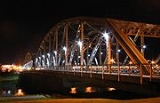
| Sorlie Memorial Bridge Sorlie Memorial Bridge The Sorlie Memorial Bridge, also known as the Red River Bridge was built in 1929 by the Minneapolis Bridge Company to connect the cities of Grand Forks, North Dakota and East Grand Forks, Minnesota. It was placed on the National Register of Historic Places in 1999.The Sorlie Memorial Bridge... |
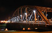 |
1929 | 1999-07-19 | Grand Forks Grand Forks, North Dakota Grand Forks is the third-largest city in the U.S. state of North Dakota and the county seat of Grand Forks County. According to the 2010 census, the city's population was 52,838, while that of the city and surrounding metropolitan area was 98,461... 47°55′37"N 97°1′40"W |
Grand Forks Grand Forks County, North Dakota -National protected areas:*Kellys Slough National Wildlife Refuge*Little Goose National Wildlife Refuge-Demographics:As of the census of 2000, there were 66,109 people, 25,435 households, and 15,617 families residing in the county. The population density was 46 people per square mile . There were... |
Parker through truss bridge |
| Viking Bridge | 1885, 1915 | 1997-02-27 | Portland Portland, North Dakota As of the census of 2000, there were 604 people, 269 households, and 161 families residing in the city. The population density was 702.0 people per square mile . There were 286 housing units at an average density of 332.4 per square mile . The racial makeup of the city was 99.50% White, 0.17%... 47°31′2"N 97°23′21"W |
Traill Traill County, North Dakota Traill County is a county located in the U.S. state of North Dakota. The 2010 census listed the population at 8,121. Its county seat is Hillsboro, and its largest city is Mayville.-History:... |
Pratt through truss | |
| West Antelope Bridge | 1907 | 1997-02-27 | Flora Flora, North Dakota Flora is an unincorporated community in Benson County, North Dakota. The unincorporated community takes its name from Flora Schuyler, having previously, until 1901, been named Schuyler after William Schuyler, her brother, who was a townsite owner.... 47°53′12"N 99°23′5"W |
Benson Benson County, North Dakota -Major highways:* U.S. Highway 2* U.S. Highway 281* North Dakota Highway 19* North Dakota Highway 20* North Dakota Highway 57-National protected areas:*Pleasant Lake National Wildlife Refuge*Silver Lake National Wildlife Refuge... |
Pratt pony truss bridge | |
| West Park Bridge | 1924 | 1997-02-27 | Valley City Valley City, North Dakota As of the census of 2000, there were 6,826 people, 2,996 households, and 1,668 families residing in the city. The population density was 2,062.5 per square mile . There were 3,250 housing units at an average density of 982.0 per square mile... 46°55′14"N 98°0′30"W |
Barnes Barnes County, North Dakota -National protected areas:*Hobart Lake National Wildlife Refuge*Stoney Slough National Wildlife Refuge*Tomahawk National Wildlife Refuge-Demographics:... |
concrete false arch bridge | |
| Westgaard Bridge | 1902 | 1997-02-27 | Voltaire Voltaire, North Dakota As of the census of 2000, there were 51 people, 20 households, 45 Dogs, 3 horses, and 14 families residing in the city. The population density was 125.1 people per square mile . There were 21 housing units at an average density of 51.5 per square mile... 48°6′51"N 100°48′33"W |
McHenry McHenry County, North Dakota -National protected areas:*Cottonwood Lake National Wildlife Refuge*J. Clark Salyer National Wildlife Refuge *Wintering River National Wildlife Refuge-Demographics:... |
Pratt pony through truss | |
| Blanchard Bridge | 1900 | 1997-02-27 removed 2009-3-25 | Blanchard Blanchard, North Dakota Blanchard is a census-designated place in Blanchard Township, Traill County, North Dakota in the United States. The population was 26 at the 2010 census.... 47°20′23"N 97°12′59"W |
Traill Traill County, North Dakota Traill County is a county located in the U.S. state of North Dakota. The 2010 census listed the population at 8,121. Its county seat is Hillsboro, and its largest city is Mayville.-History:... |
Pratt through truss | |
| Goose River Bridge Goose River Bridge (Hillsboro, North Dakota) The Goose River Bridge was a Pratt through truss bridge over the Goose River near Hillsboro, North Dakota that was built in 1893. It was listed on the National Register of Historic Places in 1997.It was delisted from the National Register on March 25, 2009.... |
1893 | 1997-02-27 removed 2009-3-25 | Hillsboro Hillsboro, North Dakota As of the census of 2010, there were 1,603 people, 679 households, and 414 families residing in the city. The population density was 1,460.6 people per square mile . There were 727 housing units at an average density of 679.4 per square mile... 47°26′41"N 96°55′15"W |
Traill Traill County, North Dakota Traill County is a county located in the U.S. state of North Dakota. The 2010 census listed the population at 8,121. Its county seat is Hillsboro, and its largest city is Mayville.-History:... |
Pratt through truss | |
| Liberty Memorial Bridge | 1920, 1922 | 1997-03-11 removed 2009-3-25 | Bismarck Bismarck, North Dakota Bismarck is the capital of the U.S. state of North Dakota and the county seat of Burleigh County. It is the second most populous city in North Dakota after Fargo. The city's population was 61,272 at the 2010 census, while its metropolitan population was 108,779... 46°48′28"N 100°49′21"W |
Burleigh Burleigh County, North Dakota -National protected areas:*Canfield Lake National Wildlife Refuge*Florence Lake National Wildlife Refuge*Long Lake National Wildlife Refuge -Demographics:... |
Warren-Turner through truss | |
| Porter Elliott Bridge | 1902 | 1997-02-27 removed 2009-3-25 | Hillsboro Hillsboro, North Dakota As of the census of 2010, there were 1,603 people, 679 households, and 414 families residing in the city. The population density was 1,460.6 people per square mile . There were 727 housing units at an average density of 679.4 per square mile... 47°26′10"N 96°56′32"W |
Traill Traill County, North Dakota Traill County is a county located in the U.S. state of North Dakota. The 2010 census listed the population at 8,121. Its county seat is Hillsboro, and its largest city is Mayville.-History:... |
Warren through truss | |
| Portland Park Bridge | 1919 | removed 2004-09-23 |
Portland Portland, North Dakota As of the census of 2000, there were 604 people, 269 households, and 161 families residing in the city. The population density was 702.0 people per square mile . There were 286 housing units at an average density of 332.4 per square mile . The racial makeup of the city was 99.50% White, 0.17%... |
Traill Traill County, North Dakota Traill County is a county located in the U.S. state of North Dakota. The 2010 census listed the population at 8,121. Its county seat is Hillsboro, and its largest city is Mayville.-History:... |
steel through girder | |
| Rainbow Arch Bridge | 1925 | removed 2004-09-23 |
Valley City Valley City, North Dakota As of the census of 2000, there were 6,826 people, 2,996 households, and 1,668 families residing in the city. The population density was 2,062.5 per square mile . There were 3,250 housing units at an average density of 982.0 per square mile... |
Barnes Barnes County, North Dakota -National protected areas:*Hobart Lake National Wildlife Refuge*Stoney Slough National Wildlife Refuge*Tomahawk National Wildlife Refuge-Demographics:... |
Marsh Rainbow Arch |