
List of bridges on the National Register of Historic Places in Connecticut
Encyclopedia
This is a list of bridge
s and tunnel
s on the National Register of Historic Places
in the U.S. state
of Connecticut
.
Bridge
A bridge is a structure built to span physical obstacles such as a body of water, valley, or road, for the purpose of providing passage over the obstacle...
s and tunnel
Tunnel
A tunnel is an underground passageway, completely enclosed except for openings for egress, commonly at each end.A tunnel may be for foot or vehicular road traffic, for rail traffic, or for a canal. Some tunnels are aqueducts to supply water for consumption or for hydroelectric stations or are sewers...
s on the National Register of Historic Places
National Register of Historic Places
The National Register of Historic Places is the United States government's official list of districts, sites, buildings, structures, and objects deemed worthy of preservation...
in the U.S. state
U.S. state
A U.S. state is any one of the 50 federated states of the United States of America that share sovereignty with the federal government. Because of this shared sovereignty, an American is a citizen both of the federal entity and of his or her state of domicile. Four states use the official title of...
of Connecticut
Connecticut
Connecticut is a state in the New England region of the northeastern United States. It is bordered by Rhode Island to the east, Massachusetts to the north, and the state of New York to the west and the south .Connecticut is named for the Connecticut River, the major U.S. river that approximately...
.
| Name | Image | Built | Listed | Location | County | Type |
|---|---|---|---|---|---|---|
| Arrawanna Bridge Arrawanna Bridge The Arrawanna Bridge in Middletown, Connecticut, USA, was built in 1918. It brought Berlin Street across the Coginchaug River. The bridge was designed by the Connecticut Highway Department as Bridge No. 4536 and is an open-spandrel concrete arch bridge. It was listed on the National Register of... |
1918 | 2004-09-29 | Middletown Middletown, Connecticut Middletown is a city located in Middlesex County, Connecticut, along the Connecticut River, in the central part of the state, 16 miles south of Hartford. In 1650, it was incorporated as a town under its original Indian name, Mattabeseck. It received its present name in 1653. In 1784, the central... 41°33′46"N 72°40′0"W |
Middlesex Middlesex County, Connecticut Middlesex County is a county located in the south central part of the U.S. state of Connecticut. It was created in 1785 from portions of Hartford and New London counties. As of 2010, the population was 165,676.... |
open-spandrel concrete arch | |
| Ashland Mill Bridge Ashland Mill Bridge The Ashland Mill Bridge is a lenticular pony truss bridge over the Pachaug River in Griswold, Connecticut that was built in 1886 by the Berlin Iron Bridge Company.The bridge was listed on the National Register of Historic Places in 1999.... |
1886 | 1999-04-01 | Griswold Griswold, Connecticut Griswold is a town in New London County, Connecticut, United States. The population was 10,807 at the 2000 census. Griswold contains one borough, Jewett City, and also contains the villages of Doaneville,Rixtown, Glasgo, Hopeville, and Pachaug... 41°31′31"N 71°58′28"W |
New London New London County, Connecticut New London County is a county located in the southeastern corner of the U.S. state of Connecticut. As of 2010 the population was 274,055. The total area of the county is , including inland and coastal waters.... |
lenitcular pony Truss | |
| Blackledge River Railroad Bridge Blackledge River Railroad Bridge The Blackledge River Railroad Bridge is a Warren truss bridge that was built in 1912. It was listed on the National Register of Historic Places in 1986. The bridge is located in Airline State Park and crosses the Blackledge River.-External links:... |
1986-07-31 | Colchester Colchester, Connecticut Colchester is a town in New London County, Connecticut, United States. The population was 14,551 at the 2000 census. In 2005 it was ranked 57th on the "100 Best Places to Live" in all of the United States, conducted by CNN... 41°35′2"N 72°25′21"W |
New London New London County, Connecticut New London County is a county located in the southeastern corner of the U.S. state of Connecticut. As of 2010 the population was 274,055. The total area of the county is , including inland and coastal waters.... |
|||
| Boardman's Bridge | 1888 | 1976-05-13 | New Milford New Milford, Connecticut New Milford is a town in southern Litchfield County, Connecticut, United States north of Danbury, on the Housatonic River. It is the largest town in the state in terms of land area at nearly . The population was 28,671 according to the Census Bureau's 2006 estimates... 41°35′36"N 73°27′2"W |
Litchfield Litchfield County, Connecticut Litchfield County is a county located in the northwestern corner of the U.S. state of Connecticut. Litchfield County has the lowest population density of any county in Connecticut but is geographically the state's largest county. As of 2010 the population was 189,927... |
Lenticular truss | |
| Bridge No. 1132 Bridge No. 1132 Bridge No. 1132 is an open-spandrel concrete arch bridge carrying the two-lane Connecticut Route 80 across the Hammonasset River, between Killingworth and Madison, Connecticut. It was listed on the National Register of Historic Places in 2004. The main arch of the bridge is 100 feet long, and... |
1934 | 2004-09-29 | Killingworth Killingworth, Connecticut Killingworth is a town in Middlesex County, Connecticut, United States. The town's name can easily be confused with another Connecticut town, Killingly; or a Vermont ski area, Killington. The population was 6,018 at the 2000 census.-History:... 41°21′33"N 72°43′15"W |
Middlesex Middlesex County, Connecticut Middlesex County is a county located in the south central part of the U.S. state of Connecticut. It was created in 1785 from portions of Hartford and New London counties. As of 2010, the population was 165,676.... |
open-spandrel concrete arch | |
| Bridge No. 1603 | 1937 | 1993-07-29 | Millington 41°29′1"N 72°20′35"W |
Middlesex Middlesex County, Connecticut Middlesex County is a county located in the south central part of the U.S. state of Connecticut. It was created in 1785 from portions of Hartford and New London counties. As of 2010, the population was 165,676.... |
Vernacular, rustic | |
| Bridge No. 1604 | 1937 | 1993-07-29 | Millington 41°28′32"N 72°20′33"W |
Middlesex Middlesex County, Connecticut Middlesex County is a county located in the south central part of the U.S. state of Connecticut. It was created in 1785 from portions of Hartford and New London counties. As of 2010, the population was 165,676.... |
Vernacular, rustic | |
| Bridge No. 1605 | 1937 | 1993-07-29 | Millington 41°28′5"N 72°20′19"W |
Middlesex Middlesex County, Connecticut Middlesex County is a county located in the south central part of the U.S. state of Connecticut. It was created in 1785 from portions of Hartford and New London counties. As of 2010, the population was 165,676.... |
Vernacular, rustic | |
| Bridge No. 1860 | 1936 | 1993-07-29 | Montville Montville, Connecticut Montville is a town in New London County, Connecticut, United States. The population was 18,546 at the 2000 census and 19,571 at the 2010 census.... 41°28′48"N 72°5′12"W |
New London New London County, Connecticut New London County is a county located in the southeastern corner of the U.S. state of Connecticut. As of 2010 the population was 274,055. The total area of the county is , including inland and coastal waters.... |
Vernacular, rustic | |
| Bridge No. 2305 | 1873 | 2007-03-09 | Salisbury Salisbury, Connecticut Salisbury is a town in Litchfield County, Connecticut, United States. The town is the northwest-most in the State of Connecticut. The MA-NY-CT Tri-State Marker is located just on the border of Salisbury... 41°58′4"N 73°26′22"W |
Litchfield Litchfield County, Connecticut Litchfield County is a county located in the northwestern corner of the U.S. state of Connecticut. Litchfield County has the lowest population density of any county in Connecticut but is geographically the state's largest county. As of 2010 the population was 189,927... |
||
| Bridge No. 455 | 1929 | 2004-09-29 | Suffield Suffield, Connecticut Suffield is a town in Hartford County, Connecticut, United States. It had once been within the boundaries of Massachusetts. The town is located in the Connecticut River Valley with the town of Enfield neighboring to the east. In 1900, 3,521 people lived in Suffield; and in 1910, 3,841. As of the... 41°57′30"N 72°37′40"W |
Hartford Hartford County, Connecticut Hartford County is a county located in the north central part of the US state of Connecticut. The 2010 Census records show that the county population is at 894,014 making it the second most populated county in Connecticut.... |
open-spandrel concrete arch | |
| Bridge No. 560 | 1930 | 2004-09-29 | Cornwall Cornwall, Connecticut Cornwall is a town in Litchfield County, Connecticut, United States. The population was 1,434 at the 2000 census.In 1939 poet Mark Van Doren wrote "The Hills of Little Cornwall", a short poem in which the beauties of the countryside were portrayed as seductive:The town was also home to the Foreign... 41°49′11"N 73°22′25"W |
Litchfield Litchfield County, Connecticut Litchfield County is a county located in the northwestern corner of the U.S. state of Connecticut. Litchfield County has the lowest population density of any county in Connecticut but is geographically the state's largest county. As of 2010 the population was 189,927... |
open spandrel concrete arch | |
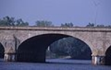
| Bulkeley Bridge Bulkeley Bridge The Bulkeley Bridge is a stone arch bridge composed of nine spans located in Hartford, Connecticut. The bridge carries Interstate 84, U.S. Route 6 and U.S. Route 44 across the Connecticut River, connecting Hartford to East Hartford... |
 |
1908 | 1993-12-10 | Hartford Hartford, Connecticut Hartford is the capital of the U.S. state of Connecticut. The seat of Hartford County until Connecticut disbanded county government in 1960, it is the second most populous city on New England's largest river, the Connecticut River. As of the 2010 Census, Hartford's population was 124,775, making... 41°46′9"N 72°39′58"W |
Hartford Hartford County, Connecticut Hartford County is a county located in the north central part of the US state of Connecticut. The 2010 Census records show that the county population is at 894,014 making it the second most populated county in Connecticut.... |
stone arch bridge Arch bridge An arch bridge is a bridge with abutments at each end shaped as a curved arch. Arch bridges work by transferring the weight of the bridge and its loads partially into a horizontal thrust restrained by the abutments at either side... |
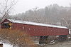
| Bull's Bridge Bull's Bridge Bull's Bridge is a single-lane vehicular wooden covered bridge across the Housatonic River in the town of Kent, Connecticut. The bridge uses lattice truss design by Ithiel Town and was built in 1842 out of timber. Queen post trusses were added later in the 19th century as secondary support. The... |
1972-04-26 | Kent Kent, Connecticut Kent is a town in Litchfield County, Connecticut, alongside the border with New York. The population was 2,858 at the 2000 census. The town is home to three New England boarding schools: South Kent School, Kent School and The Marvelwood School. The Schaghticoke Indian Reservation is also located... 41°40′32"N 73°30′35"W |
Litchfield Litchfield County, Connecticut Litchfield County is a county located in the northwestern corner of the U.S. state of Connecticut. Litchfield County has the lowest population density of any county in Connecticut but is geographically the state's largest county. As of 2010 the population was 189,927... |
Town lattice truss | ||
| Butts Bridge | 2010-5-24 | Canterbury Canterbury, Connecticut Canterbury is a town in Windham County, Connecticut, United States. The population was 4,692 at the 2000 census.-History:The area was first settled in the 1680s as Peagscomsuck, consisting mainly of land north of Norwich, south of New Roxbury, Massachusetts and west of the Quinebaug River and the... |
Windham Windham County, Connecticut Windham County is a county located in the northeastern corner of the U.S. state of Connecticut. As of 2010, the population was 118,428.The entire county is within the Quinebaug and Shetucket Rivers Valley National Heritage Corridor, as designated by the National Park Service.-History:Windham... |
|||
| Comstock's Bridge Comstock's Bridge Comstock's Bridge, also known as the Comstock Covered Bridge, is located in East Hampton, Connecticut. The bridge was built in 1840 to span the Salmon River and was added to the National Register of Historic Places on January 1, 1976.... |
1840, 1868 | 1976-01-01 | East Hampton East Hampton, Connecticut East Hampton is a town in Middlesex County, Connecticut, United States. The population was 13,352 at the 2000 census. The town center village is listed as a census-designated place... 41°33′11"N 72°26′57"W |
Middlesex Middlesex County, Connecticut Middlesex County is a county located in the south central part of the U.S. state of Connecticut. It was created in 1785 from portions of Hartford and New London counties. As of 2010, the population was 165,676.... |
Howe-truss covered bridge | |
| Depot Street Bridge | 1935 | 2007-03-09 | Beacon Falls Beacon Falls, Connecticut Beacon Falls is a town in New Haven County, Connecticut, United States. The population was 5,246 at the 2000 census. The population increased to 6,049 at the 2010 census. Beacon Falls is also home to the national-known Meteorologist Jim Cantore. Settlers from Derby, Connecticut settled Beacon... 41°26′31"N 73°3′48"W |
New Haven New Haven County, Connecticut New Haven County is a county located in the south central part of the U.S. state of Connecticut. As of the 2010 Census, the county population is 862,477 making it the third most populated county in Connecticut. There are 1,340 people per square mile... |
Parker through truss | |
| Drake Hill Road Bridge Drake Hill Road Bridge Drake Hill Road Bridge is a bridge in Simsbury, Connecticut. It is on Drake Hill Rd. at Farmington River. It was listed on the National Register of Historic Places in 1984.... |
1892 | 1984-07-19 | Simsbury Simsbury, Connecticut Simsbury is a suburban town in Hartford County, Connecticut, United States. The population was 23,234 at the 2000 census. The town was incorporated as Connecticut's twenty-first town in May 1670.-Early history:... 41°52′6"N 72°48′1"W |
Hartford Hartford County, Connecticut Hartford County is a county located in the north central part of the US state of Connecticut. The 2010 Census records show that the county population is at 894,014 making it the second most populated county in Connecticut.... |
Parker truss | |
| Farmington River Railroad Bridge | 1867 | 1972-08-25 | Windsor Windsor, Connecticut Windsor is a town in Hartford County, Connecticut, United States, and was the first English settlement in the state. It lies on the northern border of Connecticut's capital, Hartford. The population was estimated at 28,778 in 2005.... 41°51′28"N 72°38′30"W |
Hartford Hartford County, Connecticut Hartford County is a county located in the north central part of the US state of Connecticut. The 2010 Census records show that the county population is at 894,014 making it the second most populated county in Connecticut.... |
||
| Glen Falls Bridge Glen Falls Bridge Glen Falls Bridge is a historic bridge on Brunswick Avenue over the Moosup River in Plainfield, Connecticut.It was built in 1886 and added to the National Register of Historic Places in 1999.... |
1999-04-01 | Plainfield Plainfield, Connecticut Plainfield is a town in Windham County, Connecticut, United States. The population was 14,619 at the 2000 census. The town comprises four villages: Plainfield , Moosup , Wauregan , and Central Village . Each village has their own respective United States Post Office and fire department... 41°43′1"N 71°51′43"W |
Windham Windham County, Connecticut Windham County is a county located in the northeastern corner of the U.S. state of Connecticut. As of 2010, the population was 118,428.The entire county is within the Quinebaug and Shetucket Rivers Valley National Heritage Corridor, as designated by the National Park Service.-History:Windham... |
Lenticular through Truss | ||
| Hamburg Bridge Historic District Hamburg Bridge Historic District The Hamburg Bridge Historic District is located in Lyme, Connecticut. The district was added to the National Register of Historic Places on March 10, 1983.... |
1983-03-10 | Lyme Lyme, Connecticut Lyme is a town in New London County, Connecticut, United States. The population was 2,016 at the 2000 census. Lyme and its neighboring town Old Lyme are the namesake for Lyme disease.-Geography:... |
New London New London County, Connecticut New London County is a county located in the southeastern corner of the U.S. state of Connecticut. As of 2010 the population was 274,055. The total area of the county is , including inland and coastal waters.... |
Queen Anne | ||
| Housatonic River Railroad Bridge | 1904 | 1987-06-12 | Milford Milford, Connecticut Milford is a coastal city in southwestern New Haven County, Connecticut, United States, located between Bridgeport and New Haven. The population was 52,759 at the 2010 census... -Stratford Stratford, Connecticut Stratford is a town in Fairfield County, Connecticut, United States, located on Long Island Sound at the mouth of the Housatonic River. It was founded by Puritans in 1639.... 41°12′19"N 73°6′37"W |
Fairfield Fairfield County, Connecticut Fairfield County is a county located in the southwestern corner of the U.S. state of Connecticut. The county population is 916,829 according to the 2010 Census. There are currently 1,465 people per square mile in the county. It is the most populous county in the State of Connecticut and contains... |
Scherzer Rolling Lift Bascul | |
| Lover's Leap Bridge Lover's Leap Bridge Lover's Leap Bridge is a wrought-iron lenticular truss bridge over the Housatonic River located in Lovers Leap State Park in New Milford, Connecticut. It was built in 1895 by the Berlin Iron Bridge Company. Prior to 1977, the bridge was used by both vehicles and pedestrians but is now closed to... |
1895 | 1976-05-13 | New Milford New Milford, Connecticut New Milford is a town in southern Litchfield County, Connecticut, United States north of Danbury, on the Housatonic River. It is the largest town in the state in terms of land area at nearly . The population was 28,671 according to the Census Bureau's 2006 estimates... 41°32′39"N 73°24′26"W |
Litchfield Litchfield County, Connecticut Litchfield County is a county located in the northwestern corner of the U.S. state of Connecticut. Litchfield County has the lowest population density of any county in Connecticut but is geographically the state's largest county. As of 2010 the population was 189,927... |
Lenticular Bridge | |
| Lyman Viaduct Lyman Viaduct Lyman Viaduct is located over Dickinson Creek and the former Air Line Railroad right-of-way in Colchester, Connecticut.It was built in 1873 and added to the National Register of Historic Places in 1986.... |
1873 | 1986-08-21 | Colchester Colchester, Connecticut Colchester is a town in New London County, Connecticut, United States. The population was 14,551 at the 2000 census. In 2005 it was ranked 57th on the "100 Best Places to Live" in all of the United States, conducted by CNN... 41°33′53"N 72°26′46"W |
New London New London County, Connecticut New London County is a county located in the southeastern corner of the U.S. state of Connecticut. As of 2010 the population was 274,055. The total area of the county is , including inland and coastal waters.... |
||
| Main Street Bridge Main Street Bridge (Stamford, Connecticut) The Main Street Bridge in Stamford, Connecticut carries Main Street over the Rippowam River . It was built in 1888. It was designed and manufactured by the Berlin Iron Bridge Company.... |
1888 | 1987-05-21 | Stamford Stamford, Connecticut Stamford is a city in Fairfield County, Connecticut, United States. According to the 2010 census, the population of the city is 122,643, making it the fourth largest city in the state and the eighth largest city in New England... 41°3′14"N 73°32′44"W |
Fairfield Fairfield County, Connecticut Fairfield County is a county located in the southwestern corner of the U.S. state of Connecticut. The county population is 916,829 according to the 2010 Census. There are currently 1,465 people per square mile in the county. It is the most populous county in the State of Connecticut and contains... |
lenticular pony truss | |
| Melrose Road Bridge | 1888 | 1999-08-05 | East Windsor East Windsor, Connecticut East Windsor is a town in Hartford County, Connecticut, United States. The population was 11,162 at the 2010 census.The town has five villages: Broad Brook, Melrose, Scantic, Warehouse Point and Windsorville.-Area:... 41°56′18"N 72°32′51"W |
Hartford Hartford County, Connecticut Hartford County is a county located in the north central part of the US state of Connecticut. The 2010 Census records show that the county population is at 894,014 making it the second most populated county in Connecticut.... |
Lenticular pony truss | |
| Merritt Parkway Bridges Merritt Parkway Bridges The 69 original bridges of the Merritt Parkway were designed by George L. Dunkelberger. Each bridge had a unique design that represented various 1930s architectural styles, such as Art Deco, Art Moderne, French Renaissance, Gothic, Neoclassicism, and Rustic. Some of the bridges have been... |
1930s | 1991 | Greenwich, Stamford, New Canaan, Norwalk, Westport, Fairfield, Trumbull, Stratford | Fairfield County Fairfield County, Connecticut Fairfield County is a county located in the southwestern corner of the U.S. state of Connecticut. The county population is 916,829 according to the 2010 Census. There are currently 1,465 people per square mile in the county. It is the most populous county in the State of Connecticut and contains... |
Various (Contains 66 structures) | |
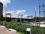
| Mianus River Railroad Bridge Mianus River Railroad Bridge The Mianus River Railroad Bridge, also known as the Cos Cob Bridge, is a bascule bridge built in 1904 over the Mianus River, in Greenwich, Connecticut. It was listed on the National Register of Historic Places in 1987... |
1904 | 1987-06-12 | Greenwich Greenwich, Connecticut Greenwich is a town in Fairfield County, Connecticut, United States. As of the 2010 census, the town had a total population of 61,171. It is home to many hedge funds and other financial service companies. Greenwich is the southernmost and westernmost municipality in Connecticut and is 38+ minutes ... 41°1′51"N 73°35′41"W |
Fairfield Fairfield County, Connecticut Fairfield County is a county located in the southwestern corner of the U.S. state of Connecticut. The county population is 916,829 according to the 2010 Census. There are currently 1,465 people per square mile in the county. It is the most populous county in the State of Connecticut and contains... |
Deck Girder,Bascule | |
| Mill Brook Bridge | 1997-01-02 | Lisbon Lisbon, Connecticut Lisbon is a town in New London County, Connecticut, United States. The population was 4,069 at the 2000 census. The town center is also known as the village of Newent... 41°33′30"N 72°2′25"W |
New London New London County, Connecticut New London County is a county located in the southeastern corner of the U.S. state of Connecticut. As of 2010 the population was 274,055. The total area of the county is , including inland and coastal waters.... |
masonry arch | ||
| Minortown Road Bridge | 1890 | 2001-08-17 | Woodbury Woodbury, Connecticut Woodbury is a town in Litchfield County, Connecticut, United States. The population was 9,198 at the 2000 census. The town center is also designated by the U.S. Census Bureau as a census-designated place . Woodbury was founded in 1672.... 41°34′36"N 73°10′34"W |
Litchfield Litchfield County, Connecticut Litchfield County is a county located in the northwestern corner of the U.S. state of Connecticut. Litchfield County has the lowest population density of any county in Connecticut but is geographically the state's largest county. As of 2010 the population was 189,927... |
Lenticular pony truss | |
| Mystic Bridge Historic District Mystic Bridge Historic District Mystic Bridge Historic District is a historic district on U.S. 1 and CT 27 in the Stonington side of the village of Mystic, Connecticut. The district represents the core of the early settlement of that name on the east bank of the Mystic River.The district features Queen Anne and Italianate... |
1979-08-31 | Mystic Mystic, Connecticut Mystic is a village and census-designated place in New London County, Connecticut, in the United States. The population was 4,001 at the 2000 census. A historic locality, Mystic has no independent government because it is not a legally recognized municipality in the state of Connecticut... |
New London New London County, Connecticut New London County is a county located in the southeastern corner of the U.S. state of Connecticut. As of 2010 the population was 274,055. The total area of the county is , including inland and coastal waters.... |
|||
| Norwalk River Railroad Bridge Norwalk River Railroad Bridge The Norwalk River Railroad Bridge — the Amtrak and Metro-North Railroad right-of-way over the Norwalk River was built in 1896, when the route was widened to four tracks... |
 |
1896 | 1987-06-12 | South Norwalk South Norwalk, Connecticut South Norwalk is a neighborhood in Norwalk, Connecticut. SoNo features a high density of bars and eateries and is the center of Norwalk's nightlife and restaurant culture... 41°6′2"N 73°24′57"W |
Fairfield Fairfield County, Connecticut Fairfield County is a county located in the southwestern corner of the U.S. state of Connecticut. The county population is 916,829 according to the 2010 Census. There are currently 1,465 people per square mile in the county. It is the most populous county in the State of Connecticut and contains... |
Rim Bearing,Swing |
| Packerville Bridge Packerville Bridge Packerville Bridge is a historic bridge carrying Packerville Road over Mill Brook in Plainfield, Connecticut. It is a masonry arch bridge with cut-stone barrel and rubble spandrels. The bridge was built in 1886 and is a well-preserved example of vernacular 19th century masonry bridge technology.... |
1886 | 1992-11-27 | Plainfield Plainfield, Connecticut Plainfield is a town in Windham County, Connecticut, United States. The population was 14,619 at the 2000 census. The town comprises four villages: Plainfield , Moosup , Wauregan , and Central Village . Each village has their own respective United States Post Office and fire department... 41°40′1"N 71°56′56"W |
Windham Windham County, Connecticut Windham County is a county located in the northeastern corner of the U.S. state of Connecticut. As of 2010, the population was 118,428.The entire county is within the Quinebaug and Shetucket Rivers Valley National Heritage Corridor, as designated by the National Park Service.-History:Windham... |
Masonry arch | |
| Pequabuck Bridge | 1832, 1833 | 1984-07-19 | Farmington Farmington, Connecticut Farmington is a town located in Hartford County in the Farmington Valley area of central Connecticut in the United States. The population was 25,340 at the 2010 census. It is home to the world headquarters of several large corporations including Carrier Corporation, Otis Elevator Company, and Carvel... 41°42′59"N 72°50′25"W |
Hartford Hartford County, Connecticut Hartford County is a county located in the north central part of the US state of Connecticut. The 2010 Census records show that the county population is at 894,014 making it the second most populated county in Connecticut.... |
||
| Pequonnock River Railroad Bridge Pequonnock River Railroad Bridge The Pequonnock River Railroad Bridge is a railroad drawbridge over the Pequonnock River in Bridgeport, Connecticut. Owned by the State of Connecticut and maintained and operated by Metro-North Railroad, it is also referred to as Pequonnock River Bridge, PECK Bridge, and Undergrade Bridge 55.90... |
1902 | 1987-06-12 | Bridgeport Bridgeport, Connecticut Bridgeport is the most populous city in the U.S. state of Connecticut. Located in Fairfield County, the city had an estimated population of 144,229 at the 2010 United States Census and is the core of the Greater Bridgeport area... 41°10′59"N 73°11′11"W |
Fairfield Fairfield County, Connecticut Fairfield County is a county located in the southwestern corner of the U.S. state of Connecticut. The county population is 916,829 according to the 2010 Census. There are currently 1,465 people per square mile in the county. It is the most populous county in the State of Connecticut and contains... |
Through Girder Bascule | |
| Perry Avenue Bridge Perry Avenue Bridge The Perry Avenue Bridge over the Silvermine River in the Silvermine section of Norwalk, Connecticut was built in 1899. It was listed on the National Register of Historic Places in 2006.... |
1899 | 2006-10-25 | Norwalk Norwalk, Connecticut Norwalk is a city in Fairfield County, Connecticut, United States. According to the 2010 U.S. Census, the population of the city is 85,603, making Norwalk sixth in population in Connecticut, and third in Fairfield County... 41°9′4"N 73°26′45"W |
Fairfield Fairfield County, Connecticut Fairfield County is a county located in the southwestern corner of the U.S. state of Connecticut. The county population is 916,829 according to the 2010 Census. There are currently 1,465 people per square mile in the county. It is the most populous county in the State of Connecticut and contains... |
Single-span Arch-deck | |
| Pine Creek Park Bridge Pine Creek Park Bridge The Pine Creek Park Bridge, also known as Mill Hill Road Bridge, is a Pratt pony truss bridge built in 1872. It was listed on the National Register of Historic Places in 1992.... |
1872, 1890, 1979 | 1992-04-08 | Fairfield Fairfield, Connecticut Fairfield is a town located in Fairfield County, Connecticut, United States. It is bordered by the towns of Bridgeport, Trumbull, Easton, Redding and Westport along the Gold Coast of Connecticut. As of the 2010 census, the town had a population of 59,404... 41°7′31"N 73°15′48"W |
Fairfield Fairfield County, Connecticut Fairfield County is a county located in the southwestern corner of the U.S. state of Connecticut. The county population is 916,829 according to the 2010 Census. There are currently 1,465 people per square mile in the county. It is the most populous county in the State of Connecticut and contains... |
Pratt pony truss bridge | |
| Rapallo Viaduct Rapallo Viaduct The Rapallo Viaduct is a filled-in former railroad bridge in East Hampton, Connecticut which carries the Air Line Trail across Flat Brook.The bridge was built as part of the New Haven, Middletown and Willimantic Railroad's line from New Haven to Willimantic, forming part of a more or less direct... |
1873 | 1986-08-21 | East Hampton East Hampton, Connecticut East Hampton is a town in Middlesex County, Connecticut, United States. The population was 13,352 at the 2000 census. The town center village is listed as a census-designated place... 41°34′19"N 72°28′19"W |
Middlesex Middlesex County, Connecticut Middlesex County is a county located in the south central part of the U.S. state of Connecticut. It was created in 1785 from portions of Hartford and New London counties. As of 2010, the population was 165,676.... |
||
| Red Bridge | 1891 | 1993-12-10 | Meriden Meriden, Connecticut Meriden is a city in New Haven County, Connecticut, United States. According to 2005 Census Bureau estimates, the population of the city is 59,653.-History:... 41°31′20"N 72°50′20"W |
New Haven New Haven County, Connecticut New Haven County is a county located in the south central part of the U.S. state of Connecticut. As of the 2010 Census, the county population is 862,477 making it the third most populated county in Connecticut. There are 1,340 people per square mile... |
||
| Reynolds Bridge Reynolds Bridge The Reynolds Bridge in Thomaston, Connecticut is an open-spandrel concrete arch bridge carrying Waterbury Road over the Naugatuck River... |
1928 | 2004-09-29 | Thomaston Thomaston, Connecticut Thomaston is a town in Litchfield County, Connecticut, United States. The population was 7,503 at the 2000 census.-History:The town, originally part of Plymouth, Connecticut, and referred to as 'Plymouth Hollow' was first settled in the early 18th century. The town is known for clock making, which... 41°39′11"N 73°4′39"W |
Litchfield Litchfield County, Connecticut Litchfield County is a county located in the northwestern corner of the U.S. state of Connecticut. Litchfield County has the lowest population density of any county in Connecticut but is geographically the state's largest county. As of 2010 the population was 189,927... |
open-spandrel concrete arch | |
| River Road Stone Arch Railroad Bridge River Road Stone Arch Railroad Bridge River Road Stone Arch Railroad Bridge is a historic bridge carrying the former Air Line Railroad right-of-way over River Road in Salmon River State Forest in Colchester, Connecticut.... |
1887 | 1986-08-21 | Colchester Colchester, Connecticut Colchester is a town in New London County, Connecticut, United States. The population was 14,551 at the 2000 census. In 2005 it was ranked 57th on the "100 Best Places to Live" in all of the United States, conducted by CNN... 41°34′49"N 72°25′32"W |
New London New London County, Connecticut New London County is a county located in the southeastern corner of the U.S. state of Connecticut. As of 2010 the population was 274,055. The total area of the county is , including inland and coastal waters.... |
||
| Riverside Avenue Bridge |  |
1871 | 1977-08-29 | Greenwich Greenwich, Connecticut Greenwich is a town in Fairfield County, Connecticut, United States. As of the 2010 census, the town had a total population of 61,171. It is home to many hedge funds and other financial service companies. Greenwich is the southernmost and westernmost municipality in Connecticut and is 38+ minutes ... 41°1′54"N 73°35′18"W |
Fairfield Fairfield County, Connecticut Fairfield County is a county located in the southwestern corner of the U.S. state of Connecticut. The county population is 916,829 according to the 2010 Census. There are currently 1,465 people per square mile in the county. It is the most populous county in the State of Connecticut and contains... |
Pratt truss |
| Saugatuck River Bridge Saugatuck River Bridge The Saugatuck River Bridge is a bridge in Connecticut carrying Route 136 over the Saugatuck River in Westport. The bridge, built in 1884, is the oldest surviving movable bridge in Connecticut and is listed on the National Register of Historic Places. The total length of the bridge is with a deck... |
1884 | 1987-02-12 | Westport Westport, Connecticut -Neighborhoods:* Saugatuck – around the Westport railroad station near the southwestern corner of the town – a built-up area with some restaurants, stores and offices.... 41°7′22"N 73°22′10"W |
Fairfield Fairfield County, Connecticut Fairfield County is a county located in the southwestern corner of the U.S. state of Connecticut. The county population is 916,829 according to the 2010 Census. There are currently 1,465 people per square mile in the county. It is the most populous county in the State of Connecticut and contains... |
Pin-connected swing bridge | |
| Saugatuck River Railroad Bridge Saugatuck River Railroad Bridge The Saugatuck River Railroad Bridge, also known as Saugatuck River Bridge, is a railroad bridge carrying trackage of Metro-North railroad's New Haven Line over the Saugatuck River in Westport, Connecticut... |
1905 | 1987-06-12 | Westport Westport, Connecticut -Neighborhoods:* Saugatuck – around the Westport railroad station near the southwestern corner of the town – a built-up area with some restaurants, stores and offices.... 41°7′10"N 73°22′8"W |
Fairfield Fairfield County, Connecticut Fairfield County is a county located in the southwestern corner of the U.S. state of Connecticut. The county population is 916,829 according to the 2010 Census. There are currently 1,465 people per square mile in the county. It is the most populous county in the State of Connecticut and contains... |
Deck Girder,Bascule | |
| Sheffield Street Bridge | 1884 | 2001-04-12 | Waterbury Waterbury, Connecticut Waterbury is a city in New Haven County, Connecticut, on the Naugatuck River, 33 miles southwest of Hartford and 77 miles northeast of New York City... 41°35′50"N 73°2′52"W |
New Haven New Haven County, Connecticut New Haven County is a county located in the south central part of the U.S. state of Connecticut. As of the 2010 Census, the county population is 862,477 making it the third most populated county in Connecticut. There are 1,340 people per square mile... |
Lenticular pony truss | |
| Skilton Road Bridge | 1991-12-10 | Watertown Watertown, Connecticut Watertown is a town in Litchfield County, Connecticut, United States. The population was 21,661 at the 2000 census. The zip code for Watertown is 06795. It is a suburb of Waterbury. It borders the towns of Woodbury, Middlebury, Litchfield, Plymouth, Bethlehem, and Thomaston.-Founding History:More... 41°37′45"N 73°9′33"W |
Litchfield Litchfield County, Connecticut Litchfield County is a county located in the northwestern corner of the U.S. state of Connecticut. Litchfield County has the lowest population density of any county in Connecticut but is geographically the state's largest county. As of 2010 the population was 189,927... |
Masonry-arch bridge | ||
| Starr Mill Road Bridge Starr Mill Road Bridge - Description :Address: At the intersection of Beverly Heights and Middlefield Street, Middletown, ConnecticutStyle: IndustrialDate of Construction:1927Materials: SteelStructural System: Steel Framing SuspensionDesigner: Berlin Construction Company... |
 |
1927 | 1993-12-10 | Middletown Middletown, Connecticut Middletown is a city located in Middlesex County, Connecticut, along the Connecticut River, in the central part of the state, 16 miles south of Hartford. In 1650, it was incorporated as a town under its original Indian name, Mattabeseck. It received its present name in 1653. In 1784, the central... 41°32′56"N 72°40′38"W |
Middlesex Middlesex County, Connecticut Middlesex County is a county located in the south central part of the U.S. state of Connecticut. It was created in 1785 from portions of Hartford and New London counties. As of 2010, the population was 165,676.... |
|
| Stone Bridge | 1833 | 1985-03-28 | Hartford Hartford, Connecticut Hartford is the capital of the U.S. state of Connecticut. The seat of Hartford County until Connecticut disbanded county government in 1960, it is the second most populous city on New England's largest river, the Connecticut River. As of the 2010 Census, Hartford's population was 124,775, making... 41°45′44"N 72°40′36"W |
Hartford Hartford County, Connecticut Hartford County is a county located in the north central part of the US state of Connecticut. The 2010 Census records show that the county population is at 894,014 making it the second most populated county in Connecticut.... |
||
| Town Bridge | 1895 | 1999-08-05 | Canton Canton, Connecticut Canton is a rural town, incorporated in 1806, in Hartford County, Connecticut. The population was 8,840 at the 2000 census, and has grown to 10,292 as of the 2010 census. It is bordered by Granby on the north, Simsbury on the east, Avon and Burlington on the south, New Hartford on the west, and... 41°49′28"N 72°55′43"W |
Hartford Hartford County, Connecticut Hartford County is a county located in the north central part of the US state of Connecticut. The 2010 Census records show that the county population is at 894,014 making it the second most populated county in Connecticut.... |
Parker through truss | |
| Turn-of-River Bridge Turn-of-River Bridge The Turn-of-River Bridge, also known as Old North Stamford Road Bridge, is a lenticular pony truss bridge built by the Berlin Iron Bridge Company in 1892. It was listed on the National Register of Historic Places in 1987.... |
1892, 1893 | 1987-07-31 | Stamford Stamford, Connecticut Stamford is a city in Fairfield County, Connecticut, United States. According to the 2010 census, the population of the city is 122,643, making it the fourth largest city in the state and the eighth largest city in New England... 41°6′54"N 73°32′42"W |
Fairfield Fairfield County, Connecticut Fairfield County is a county located in the southwestern corner of the U.S. state of Connecticut. The county population is 916,829 according to the 2010 Census. There are currently 1,465 people per square mile in the county. It is the most populous county in the State of Connecticut and contains... |
Lenticular pony truss | |
| Washington Avenue Bridge | 1881 | 2001-04-12 | Waterbury Waterbury, Connecticut Waterbury is a city in New Haven County, Connecticut, on the Naugatuck River, 33 miles southwest of Hartford and 77 miles northeast of New York City... 41°32′38"N 73°2′18"W |
New Haven New Haven County, Connecticut New Haven County is a county located in the south central part of the U.S. state of Connecticut. As of the 2010 Census, the county population is 862,477 making it the third most populated county in Connecticut. There are 1,340 people per square mile... |
Lenticular pony truss | |
| Washington Bridge Washington Bridge (Connecticut) The Washington Bridge carries U.S. Route 1 over the Housatonic River in the U.S. state of Connecticut, connecting the city of Milford to the town of Stratford. Its geographic location is N 41.20037 by W -73.11039... |
1921 | 2004-09-29 | Milford Milford, Connecticut Milford is a coastal city in southwestern New Haven County, Connecticut, United States, located between Bridgeport and New Haven. The population was 52,759 at the 2010 census... & Stratford Stratford, Connecticut Stratford is a town in Fairfield County, Connecticut, United States, located on Long Island Sound at the mouth of the Housatonic River. It was founded by Puritans in 1639.... 41°12′1"N 73°6′39"W |
Fairfield Fairfield County, Connecticut Fairfield County is a county located in the southwestern corner of the U.S. state of Connecticut. The county population is 916,829 according to the 2010 Census. There are currently 1,465 people per square mile in the county. It is the most populous county in the State of Connecticut and contains... & New Haven New Haven County, Connecticut New Haven County is a county located in the south central part of the U.S. state of Connecticut. As of the 2010 Census, the county population is 862,477 making it the third most populated county in Connecticut. There are 1,340 people per square mile... |
open-spandrel concrete arch (bascule bridge) | |
| West Cornwall Covered Bridge West Cornwall Covered Bridge The West Cornwall Covered Bridge is a wooden lattice truss bridge built over the Housatonic River in the town of Cornwall, Connecticut. It is estimated to have been built around 1864.-Details:... |
 |
1864 | 1975-12-30 | West Cornwall 41°52′18"N 73°21′52"W |
Litchfield Litchfield County, Connecticut Litchfield County is a county located in the northwestern corner of the U.S. state of Connecticut. Litchfield County has the lowest population density of any county in Connecticut but is geographically the state's largest county. As of 2010 the population was 189,927... |
Town lattice truss |
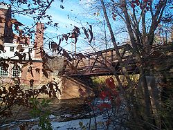
| Willimantic Footbridge Willimantic Footbridge The Willimantic Footbridge is a footbridge in the Willimantic section of Windham, Connecticut.It was built in 1906 to connect the northern and southern parts of the city.This bridge is a popular site in Willimantic.... |
1906 | 1979-04-19 | Willimantic Willimantic, Connecticut Willimantic is a census-designated place and former city located in the town of Windham in Windham County, Connecticut, United States. The population was estimated at 15,823 at the 2000 census. It is home to Eastern Connecticut State University, as well as the Windham Textile and History Museum.... 41°42′36"N 72°12′53"W |
Windham Windham County, Connecticut Windham County is a county located in the northeastern corner of the U.S. state of Connecticut. As of 2010, the population was 118,428.The entire county is within the Quinebaug and Shetucket Rivers Valley National Heritage Corridor, as designated by the National Park Service.-History:Windham... |
Steel truss footbridge |