

List of Registered Historic Places in the United States Virgin Islands
Encyclopedia
National Register of Historic Places
The National Register of Historic Places is the United States government's official list of districts, sites, buildings, structures, and objects deemed worthy of preservation...
in the United States Virgin Islands
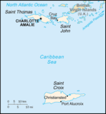
United States Virgin Islands
The Virgin Islands of the United States are a group of islands in the Caribbean that are an insular area of the United States. The islands are geographically part of the Virgin Islands archipelago and are located in the Leeward Islands of the Lesser Antilles.The U.S...
. There are currently 86 listed sites spread across 16 of the 3 islands/districts of the United States Virgin Islands
Districts and sub-districts of the United States Virgin Islands
The United States Virgin Islands are administratively divided into 3 districts, which are subdivided into 20 subdistricts.The districts are:# Saint Croix# Saint Thomas# Saint John...
. Four sites are additionally designated National Historic Landmark
National Historic Landmark
A National Historic Landmark is a building, site, structure, object, or district, that is officially recognized by the United States government for its historical significance...
s and two others as National Historic Site
National Historical Park
National Historic Sites are protected areas of national historic significance in the United States. A National Historic Site usually contains a single historical feature directly associated with its subject...
s.
Numbers of listings
The following are approximate tallies of current listings in the United States Virgin Islands on the National Register of Historic Places. These counts are based on entries in the National Register Information Database as of April 24, 2008 and new weekly listings posted since then on the National Register of Historic Places web site. There are frequent additions to the listings and occasional delistings and the counts here are not official. Also, the counts in this table exclude boundary increase and decrease listings which modify the area covered by an existing property or district and which carry a separate National Register reference number.| District | # of Sites | |
|---|---|---|
| 1 | Saint Croix | 39 |
| 2 | Saint John | 25 |
| 3 | Saint Thomas | 22 |
| Total: | 86 | |
Saint CroixSaint Croix, U.S. Virgin IslandsSaint Croix is an island in the Caribbean Sea, and a county and constituent district of the United States Virgin Islands , an unincorporated territory of the United States. Formerly the Danish West Indies, they were sold to the United States by Denmark in the Treaty of the Danish West Indies of...
| Landmark name | Image | Date listed | Location | Subdistrict | Summary | |
|---|---|---|---|---|---|---|
| 1 | Aklis Archeological Site | Address Restricted | Frederiksted | |||
| 2 | Bethlehem Middle Works Historic District | King's Quarter 17°43′3.5"N 64°47′33"W |
Southcentral | |||
| 3 | Christiansted Historic District | Roughly bounded by Christiansted Harbor, New, Peter's Farm Hospital, and West Streets 17°44′46"N 64°42′16"W |
Christiansted | |||
| 4 | Christiansted National Historic Site Christiansted National Historic Site Christiansted National Historic Site commemorates urban colonial development of the Virgin Islands. It features 18th and 19th century structures in the heart of Christiansted, the capital of the former Danish West Indies on St... |
Bounded by King, Queen, and Queens Cross Streets and Christiansted Harbor 17°44′56"N 64°42′8"W |
Christiansted | |||
| 5 | Coakley Bay Estate | East of Christiansted 17°45′41.5"N 64°38′27"W |
East End | |||
| 6 | Columbus Landing Site | 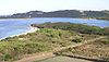 |
East of Greig Hill on Salt River Bay Salt River Bay National Historical Park and Ecological Preserve Salt River Bay National Historical Park and Ecological Preserve on the Virgin Island of St. Croix, contains the only known site where members of a Columbus expedition set foot on what is now United States territory. It also preserves upland watersheds, mangrove forests, and estuarine and marine... |
East End | ||
| 7 | Danish West India and Guinea Company Warehouse | Church and Company Streets 17°44′55.5"N 64°42′9"W |
Christiansted | |||
| 8 | Diamond School | West of Christiansted on Centerline Road 17°42′46.5"N 64°49′47"W |
Southcentral | |||
| 9 | Estate Butler's Bay | North of Frederiksted 17°44′56.5"N 64°53′32"W |
Northwest | |||
| 10 | Estate Grove Place | 4 miles (6.4 km) east of Frederiksted off Centerline Road 17°40′43.5"N 64°49′23"W |
Northwest | |||
| 11 | Estate Hogansborg | East of Frederiksted off Centerline Road 17°42′39.5"N 64°50′44"W |
Northwest | |||
| 12 | Estate Judith's Fancy | 4 miles (6.4 km) northwest of Christiansted 17°46′41.5"N 64°44′44.5"W |
Sion Farm | |||
| 13 | Estate La Reine | 20 Kings Quarter and 19 Queens Quarter 17°44′9.5"N 64°46′19"W |
Northcentral | |||
| 14 | Estate Little Princess Estate Little Princess Estate Little Princess is a historic plantation site located Northwest of Christiansted in Saint Croix, U.S. Virgin Islands. It was built in 1749 by governor Frederik Moth and rests on 25 acres of land . As of 2011 the estate is under ownership of The Nature Conservancy and serves as headquarters... |
Northwest of Christiansted 17°45′35.5"N 64°43′31"W |
Sion Farm | |||
| 15 | Estate Mount Victory | Northeast of Frederiksted 17°45′13.5"N 64°52′5"W |
Northwest | |||
| 16 | Estate Prosperity | North of Frederiksted 17°43′42.5"N 64°52′53"W |
Northwest | |||
| 17 | Estate Saint George Historic District | Prince Quarter 17°43′4.5"N 64°49′48.5"W |
Northwest | |||
| 18 | Estate St. John | 3 miles (4.8 km) northwest of Christiansted 17°45′57.5"N 64°44′48"W |
Sion Farm | |||
| 19 | Fair Plain Archeological District | Address Restricted | Christiansted | |||
| 20 | Fairplain Historic and Archeological District | Address Restricted | Christiansted | |||
| 21 | Frederiksted Historic District Frederiksted Historic District Frederiksted Historic District is a historic district in Frederiksted, United States Virgin Islands. It includes Fort Frederik. It was listed on the U.S. National Register of Historic Places in 1976.... |
Roughly bounded by Fisher Street, the cemetery, and Fort Frederik Fort Frederik Fort Frederik, also known as Frederiksfort, is a U.S. National Historic Landmark in Frederiksted, United States Virgin Islands. It was built between 1752 and 1760 by Denmark.... 17°42′44"N 64°52′53"W |
Frederiksted | |||
| 22 | Friedensfeld Midlands Moravian Church and Manse Friedensfeld Midlands Moravian Church and Manse Friedensfeld Midlands Moravian Church and Manse are a historic buildings in Christiansted, Virgin Islands.The church was built in 1810 and added to the National Register of Historic Places in 1976.... |
West of Christiansted 17°44′53.5"N 64°46′48"W |
Northcentral | |||
| 23 | Friedensthal Mission | Southwest of Christiansted 17°44′38.5"N 64°42′35"W |
Christiansted | |||
| 24 | Ft. Frederik of US Virgin Islands Fort Frederik Fort Frederik, also known as Frederiksfort, is a U.S. National Historic Landmark in Frederiksted, United States Virgin Islands. It was built between 1752 and 1760 by Denmark.... |
.jpg) |
South of junction of Mahogany Road and U.S. Virgin Island Highway 631, north end of Frederiksted 17°42′55"N 64°53′1"W |
Frederiksted | ||
| 25 | Great Pond Archeological Site | Address Restricted | Christiansted | |||
| 26 | Green Kay | East of Christiansted 17°45′39.5"N 64°38′13"W |
East End | |||
| 27 | La Grande Princesse School | Northeast of Christiansted 17°45′29.5"N 64°43′51"W |
Sion Farm | |||
| 28 | Little La Grange | Northeast of Frederiksted 17°43′47.5"N 64°51′54"W |
Northwest | |||
| 29 | Lower Granard Archeological District | Address Restricted | Christiansted | |||
| 30 | Prosperity Archeological Site | Address Restricted | Frederiksted | |||
| 31 | Richmond Prison Detention and Workhouse | West of Christiansted 17°44′53.5"N 64°42′45"W |
Christiansted | |||
| 32 | River Archeological Site | Address Restricted | Frederiksted | |||
| 33 | Salt River Bay National Historic Site and Ecological Preserve Salt River Bay National Historical Park and Ecological Preserve Salt River Bay National Historical Park and Ecological Preserve on the Virgin Island of St. Croix, contains the only known site where members of a Columbus expedition set foot on what is now United States territory. It also preserves upland watersheds, mangrove forests, and estuarine and marine... |
2100 Church Street 17°46′52"N 64°45′23"W |
Christiansted | |||
| 34 | Sion Hill | West of Christiansted 17°44′34.5"N 64°44′41"W |
Sion Farm | |||
| 35 | Slob Historic District | King's Quarter 17°43′54"N 64°46′16"W |
Sion Farm | |||
| 36 | St. Georges Archeological Site | Address Restricted | Frederiksted | |||
| 37 | Strawberry Hill Historic District | Queen's Quarter | Sion Farm | |||
| 38 | Upper Salt River Archeological District | Address Restricted | Christiansted | |||
| 39 | Whim | 1.7 miles (2.7 km) southeast of Frederiksted on Centerline Road 17°42′9.5"N 64°51′47"W |
Southwest |
Saint JohnSaint John, U.S. Virgin IslandsSaint John is an island in the Caribbean Sea and a constituent district of the United States Virgin Islands , an unincorporated territory of the United States. St...
| Landmark name | Image | Date listed | Location | Subdistrict | Summary | |
|---|---|---|---|---|---|---|
| 1 | Annaberg Historic District Annaberg Historic District Annaberg Historic District is a historic section of Saint John, United States Virgin Islands where the Annaberg sugar plantation ruins are located. The district is located on the north shore of the island west of Mary's Point in the Maho Bay quarter.... |
 |
Northwest of Coral Bay Coral Bay, United States Virgin Islands Coral Bay is a town on the island of St. John in the United States Virgin Islands. It is located on the southeastern side of the island. Though it was once the main commercial and population center on the island due to its sheltered harbor, it has fallen from prominence with the introduction of a... , Leinster Bay 18°21′53"N 64°44′18"W |
Central | ||
| 2 | Brown Bay Plantation Historic District | North of Palestina Palestina, United States Virgin Islands Palestina is a settlement on the island of St. John in the United States Virgin Islands located at . It is located in the east of the island on the coast of Coral Bay, to the east of the town of Coral Bay.-References:... 18°21′47"N 64°42′25.5"W |
Central | Virgin Islands National Park MRA | ||
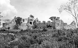
| 3 | Catherineberg-Jockumsdahl-Herman Farm Catherineberg Sugar Mill Ruins Catherineberg Sugar Mill Ruins is an historic site located in the Virgin Islands National Park, east of Cruz Bay on Saint John, U.S. Virgin Islands... |
 |
East of Cruz Bay Cruz Bay, United States Virgin Islands Cruz Bay is the main town on the island of Saint John in the United States Virgin Islands. According to the 2000 Census, Cruz Bay has a population of 2,743 people.... 18°20′49"N 64°45′39"W |
Central | Virgin Islands National Park MRA | |
| 4 | Cinnamon Bay Plantation Cinnamon Bay Plantation Cinnamon Bay Plantation is an approximately property situated on the north central coast of Saint John in the United States Virgin Islands adjacent to Cinnamon Bay. The land, part of Virgin Islands National Park, was added to the United States National Register of Historic Places on July 11, 1978... |
Northeast of Cruz Bay Cruz Bay, United States Virgin Islands Cruz Bay is the main town on the island of Saint John in the United States Virgin Islands. According to the 2000 Census, Cruz Bay has a population of 2,743 people.... on Cinnamon Bay Cinnamon Bay Cinnamon Bay is a body of water and a beach on St. John in the United States Virgin Islands, adjacent to the historic Cinnamon Bay Plantation. The bay is just east of Trunk Bay, and is about a mile west of a famous eco-tourism destination called Maho Bay Camps... 18°21′15"N 64°45′15"W |
Central | Virgin Islands National Park MRA | ||
| 5 | Congo Cay Archeological District | Address Restricted | Cruz Bay Cruz Bay, United States Virgin Islands Cruz Bay is the main town on the island of Saint John in the United States Virgin Islands. According to the 2000 Census, Cruz Bay has a population of 2,743 people.... |
Virgin Islands National Park MRA | ||
| 6 | Dennis Bay Historic District | Northeast of Cruz Bay off North Shore Road 18°21′15"N 64°46′33"W |
Central | Virgin Islands National Park MRA | ||
| 7 | Emmaus Moravian Church and Manse | West of Palestina Palestina, United States Virgin Islands Palestina is a settlement on the island of St. John in the United States Virgin Islands located at . It is located in the east of the island on the coast of Coral Bay, to the east of the town of Coral Bay.-References:... 18°21′1"N 64°42′48"W |
Coral Bay Coral Bay, United States Virgin Islands Coral Bay is a town on the island of St. John in the United States Virgin Islands. It is located on the southeastern side of the island. Though it was once the main commercial and population center on the island due to its sheltered harbor, it has fallen from prominence with the introduction of a... |
|||
| 8 | Enighed | Cruz Bay Quarter 18°19′54"N 64°47′30"W |
Cruz Bay Cruz Bay, United States Virgin Islands Cruz Bay is the main town on the island of Saint John in the United States Virgin Islands. According to the 2000 Census, Cruz Bay has a population of 2,743 people.... |
|||
| 9 | Estate Beverhoudt | 1.5 miles (2.4 km) east of Cruz Bay Cruz Bay, United States Virgin Islands Cruz Bay is the main town on the island of Saint John in the United States Virgin Islands. According to the 2000 Census, Cruz Bay has a population of 2,743 people.... off Center Line Road 18°20′27"N 64°46′19"W |
Central | |||
| 10 | Estate Carolina Sugar Plantation | West of Coral Bay on King Hill Road 18°20′58"N 64°43′7"W |
Coral Bay Coral Bay, United States Virgin Islands Coral Bay is a town on the island of St. John in the United States Virgin Islands. It is located on the southeastern side of the island. Though it was once the main commercial and population center on the island due to its sheltered harbor, it has fallen from prominence with the introduction of a... |
|||
| 11 | Fortsberg | Southeast of Coral Bay 18°20′45"N 64°42′20"W |
Coral Bay Coral Bay, United States Virgin Islands Coral Bay is a town on the island of St. John in the United States Virgin Islands. It is located on the southeastern side of the island. Though it was once the main commercial and population center on the island due to its sheltered harbor, it has fallen from prominence with the introduction of a... |
|||
| 12 | Hermitage Plantation Historic District | East End Road, Hurricane Hole 18°21′32"N 64°41′59"W |
Central | Virgin Islands National Park MRA | ||
| 13 | HMS Santa Monica | Address Restricted | Coral Bay Coral Bay, United States Virgin Islands Coral Bay is a town on the island of St. John in the United States Virgin Islands. It is located on the southeastern side of the island. Though it was once the main commercial and population center on the island due to its sheltered harbor, it has fallen from prominence with the introduction of a... |
|||
| 14 | Jossie Gut Historic District | West of Coral Bay off Center Line Road, Reef Bay 18°20′32"N 64°44′25"W |
Ceentral | Virgin Islands National Park MRA | ||
| 15 | L'Esperance Historic District | East of Cruz Bay off Center Line Road, Reef Bay 18°20′33"N 64°45′30"W |
Central | Virgin Islands National Park MRA | ||
| 16 | Lameshur Plantation | East of Cruz Bay Cruz Bay, United States Virgin Islands Cruz Bay is the main town on the island of Saint John in the United States Virgin Islands. According to the 2000 Census, Cruz Bay has a population of 2,743 people.... on Little Lameshur Bay 18°20′33"N 64°45′30"W |
Central | Virgin Islands National Park MRA | ||
| 17 | Liever Marches Bay Historic District | East of Brown Bay 18°21′16"N 64°42′4"W |
Central | Virgin Islands National Park MRA | ||
| 18 | Lind Point Fort | Northwest of Cruz Bay Cruz Bay, United States Virgin Islands Cruz Bay is the main town on the island of Saint John in the United States Virgin Islands. According to the 2000 Census, Cruz Bay has a population of 2,743 people.... 18°20′13"N 64°47′50"W |
Central | Virgin Islands National Park MRA | ||
| 19 | Mary Point Estate Mary Point Estate Mary Point Estate is a historic property located on the north coast of Saint John, United States Virgin Islands on Mary's Point. The plantation was added to the U.S. National Register of Historic Places on May 22, 1978.-History:... |
 |
Northeast of Cruz Bay Cruz Bay, United States Virgin Islands Cruz Bay is the main town on the island of Saint John in the United States Virgin Islands. According to the 2000 Census, Cruz Bay has a population of 2,743 people.... 18°22′6"N 64°44′29"W |
Central | Virgin Islands National Park MRA | |
| 20 | More Hill Historic District | Off East End Road 18°21′40"N 64°41′37"W |
East End | Virgin Islands National Park MRA | ||
| 21 | Petroglyph Site | Reef Bay | Central | |||
| 22 | Reef Bay Great House Historic District | West of Bordeaux, Reef Bay 18°19′55.5"N 64°44′23"W |
Central | Virgin Islands National Park MRA | ||
| 23 | Reef Bay Sugar Factory Historic District Reef Bay Sugar Factory Historic District Reef Bay Sugar Factory Historic District is a historic section of Saint John, United States Virgin Islands located on the south central coast adjacent to Reef Bay. The land is the site of a sugar factory. The property was added to the U.S. National Register of Historic Places on July 23, 1981.The... |
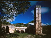 |
East of Cruz Bay Cruz Bay, United States Virgin Islands Cruz Bay is the main town on the island of Saint John in the United States Virgin Islands. According to the 2000 Census, Cruz Bay has a population of 2,743 people.... , Reef Bay 18°19′31"N 64°44′40"W |
Central | Virgin Islands National Park MRA | |
| 24 | Rustenberg Plantation South Historic District | West of Coral Bay off Center Line Road, Cinnamon Bay Cinnamon Bay Cinnamon Bay is a body of water and a beach on St. John in the United States Virgin Islands, adjacent to the historic Cinnamon Bay Plantation. The bay is just east of Trunk Bay, and is about a mile west of a famous eco-tourism destination called Maho Bay Camps... 18°20′42"N 64°44′59"W |
Central | Virgin Islands National Park MRA | ||
| 25 | Trunk Bay Sugar Factory | Northeast of Cruz Bay on North Shore Road, Trunk Bay 18°21′35.5"N 64°46′2"W |
Central | Virgin Islands National Park MRA |
Saint ThomasSaint Thomas, U.S. Virgin IslandsSaint Thomas is an island in the Caribbean Sea and with the islands of Saint John, Saint Croix, and Water Island a county and constituent district of the United States Virgin Islands , an unincorporated territory of the United States. Located on the island is the territorial capital and port of...
| Landmark name | Image | Date listed | Location | Subdistrict | Summary | |
|---|---|---|---|---|---|---|
| 1 | Bordeaux | West of Charlotte Amalie Charlotte Amalie, United States Virgin Islands -Education:St. Thomas-St. John School District serves the community. and Charlotte Amalie High School serve the area.-Gallery:-See also:* Anna's Retreat* Cruz Bay* Saint Thomas* Water Island-External links:* *... 18°21′47"N 65°0′59"W |
West End | |||
| 2 | Botany Bay Archeological District | Address Restricted | Charlotte Amalie Charlotte Amalie, United States Virgin Islands -Education:St. Thomas-St. John School District serves the community. and Charlotte Amalie High School serve the area.-Gallery:-See also:* Anna's Retreat* Cruz Bay* Saint Thomas* Water Island-External links:* *... |
|||
| 3 | Charlotte Amalie Historic District | Roughly bounded by Nytvaer, Berg and Government Hills, Bjebre Gade and St. Thomas Harbor 18°20′42"N 64°55′55"W |
Charlotte Amalie Charlotte Amalie, United States Virgin Islands -Education:St. Thomas-St. John School District serves the community. and Charlotte Amalie High School serve the area.-Gallery:-See also:* Anna's Retreat* Cruz Bay* Saint Thomas* Water Island-External links:* *... |
|||
| 4 | Estate Botany Bay | West of Charlotte Amalie Charlotte Amalie, United States Virgin Islands -Education:St. Thomas-St. John School District serves the community. and Charlotte Amalie High School serve the area.-Gallery:-See also:* Anna's Retreat* Cruz Bay* Saint Thomas* Water Island-External links:* *... 18°21′37"N 65°1′53"W |
West End | |||
| 5 | Estate Brewers Bay | 2 miles (3.2 km) west of Charlotte Amalie at Brewers Bay 18°20′51"N 64°58′45"W |
Charlotte Amalie Charlotte Amalie, United States Virgin Islands -Education:St. Thomas-St. John School District serves the community. and Charlotte Amalie High School serve the area.-Gallery:-See also:* Anna's Retreat* Cruz Bay* Saint Thomas* Water Island-External links:* *... |
|||
| 6 | Estate Hafensight | South of Charlotte Amalie 18°16′56"N 64°55′18"W |
Charlotte Amalie Charlotte Amalie, United States Virgin Islands -Education:St. Thomas-St. John School District serves the community. and Charlotte Amalie High School serve the area.-Gallery:-See also:* Anna's Retreat* Cruz Bay* Saint Thomas* Water Island-External links:* *... |
|||
| 7 | Estate Neltjeberg | Northwest of Charlotte Amalie 18°22′13"N 64°57′58"W |
West End | |||
| 8 | Estate Niesky | 1.5 miles (2.4 km) west of Charlotte Amalie off Harwood Highway 18°20′19"N 64°57′6"W |
Charlotte Amalie Charlotte Amalie, United States Virgin Islands -Education:St. Thomas-St. John School District serves the community. and Charlotte Amalie High School serve the area.-Gallery:-See also:* Anna's Retreat* Cruz Bay* Saint Thomas* Water Island-External links:* *... |
|||
| 9 | Estate Perseverance | West of Charlotte Amalie, Virgin Islands 18°21′18"N 64°59′51"W |
West End | |||
| 10 | Fort Christian Fort Christian Fort Christian is a Danish-built fort in Saint Thomas, U.S. Virgin Islands. It was constructed by the Danish government in the 17th century who occupied the small Caribbean island. As the oldest standing structure in the U.S. Virgin Islands, this fort has served as a town center, a government... |
 |
At Saint Thomas Harbor 18°20′26"N 64°55′47"W |
Charlotte Amalie Charlotte Amalie, United States Virgin Islands -Education:St. Thomas-St. John School District serves the community. and Charlotte Amalie High School serve the area.-Gallery:-See also:* Anna's Retreat* Cruz Bay* Saint Thomas* Water Island-External links:* *... |
Danish fort, the oldest structure in the U.S. Virgin Islands | |
| 11 | Hamburg-America Shipping Line Administrative Offices | 48B Tolbod Gade 18°20′30"N 64°55′53"W |
Charlotte Amalie Charlotte Amalie, United States Virgin Islands -Education:St. Thomas-St. John School District serves the community. and Charlotte Amalie High School serve the area.-Gallery:-See also:* Anna's Retreat* Cruz Bay* Saint Thomas* Water Island-External links:* *... |
|||
| 12 | Hassel Island Hassel Island, U.S. Virgin Islands Hassel Island is a small island of the U.S. Virgin Islands, a United States territory located in the Caribbean Sea. Hassel Island lies in the Charlotte Amalie harborjust south of Saint Thomas and east of Water Island.... |
South of Charlotte Amalie in Saint Thomas Harbor 18°19′46"N 64°56′8"W |
Charlotte Amalie Charlotte Amalie, United States Virgin Islands -Education:St. Thomas-St. John School District serves the community. and Charlotte Amalie High School serve the area.-Gallery:-See also:* Anna's Retreat* Cruz Bay* Saint Thomas* Water Island-External links:* *... |
|||
| 13 | Hull Bay Archeological District | Address Restricted | Charlotte Amalie Charlotte Amalie, United States Virgin Islands -Education:St. Thomas-St. John School District serves the community. and Charlotte Amalie High School serve the area.-Gallery:-See also:* Anna's Retreat* Cruz Bay* Saint Thomas* Water Island-External links:* *... |
|||
| 14 | Krum Bay Archeological District | Address Restricted | Charlotte Amalie Charlotte Amalie, United States Virgin Islands -Education:St. Thomas-St. John School District serves the community. and Charlotte Amalie High School serve the area.-Gallery:-See also:* Anna's Retreat* Cruz Bay* Saint Thomas* Water Island-External links:* *... |
|||
| 15 | Mafolie Great House | North of Charlotte Amalie Charlotte Amalie, United States Virgin Islands -Education:St. Thomas-St. John School District serves the community. and Charlotte Amalie High School serve the area.-Gallery:-See also:* Anna's Retreat* Cruz Bay* Saint Thomas* Water Island-External links:* *... 18°21′13"N 64°55′42"W |
Northside | |||
| 16 | Magens Bay Archeological District | Address Restricted | Charlotte Amalie Charlotte Amalie, United States Virgin Islands -Education:St. Thomas-St. John School District serves the community. and Charlotte Amalie High School serve the area.-Gallery:-See also:* Anna's Retreat* Cruz Bay* Saint Thomas* Water Island-External links:* *... |
|||
| 17 | New Herrnhut Moravian Church New Herrnhut Moravian Church New Herrnhut Moravian Church is a historic Moravian church in Charlotte Amalie, Virgin Islands.It was built in 1737 and added to the National Register of Historic Places in 1976.... |
East of Charlotte Amalie Charlotte Amalie, United States Virgin Islands -Education:St. Thomas-St. John School District serves the community. and Charlotte Amalie High School serve the area.-Gallery:-See also:* Anna's Retreat* Cruz Bay* Saint Thomas* Water Island-External links:* *... 18°20′13"N 64°54′5"W |
Northside | |||
| 18 | Skytsborg Blackbeard's Castle Blackbeard's Castle is one of five National Historic Landmarks in the U.S. Virgin Islands. It is located in the city of Charlotte Amalie, on the island of St. Thomas. Built in 1679 by the Danes as a watchtower to protect the harbor, it was originally called Skytsborg Tower... |
 |
39 Donningens Gade 18°20′46"N 64°55′46"W |
Charlotte Amalie Charlotte Amalie, United States Virgin Islands -Education:St. Thomas-St. John School District serves the community. and Charlotte Amalie High School serve the area.-Gallery:-See also:* Anna's Retreat* Cruz Bay* Saint Thomas* Water Island-External links:* *... |
||
| 19 | St. Thomas Synagogue St. Thomas Synagogue St. Thomas Synagogue is an historic synagogue in Charlotte Amalie on the island of Saint Thomas in the U.S. Virgin Islands. The real name of the synagogue is Beracha Veshalom Vegmiluth Hasidim. It was declared a National Historic Landmark in 1997.... |
Crystal Gade #16AB, Queens Quarters 18°20′42.5"N 64°19′28"W |
Charlotte Amalie Charlotte Amalie, United States Virgin Islands -Education:St. Thomas-St. John School District serves the community. and Charlotte Amalie High School serve the area.-Gallery:-See also:* Anna's Retreat* Cruz Bay* Saint Thomas* Water Island-External links:* *... |
|||
| 20 | St. Thomas Synagogue-Beracha Veshalom Vegemiluth Hasadim St. Thomas Synagogue St. Thomas Synagogue is an historic synagogue in Charlotte Amalie on the island of Saint Thomas in the U.S. Virgin Islands. The real name of the synagogue is Beracha Veshalom Vegmiluth Hasidim. It was declared a National Historic Landmark in 1997.... |
16AB Krystal Gade 18°20′42.5"N 64°19′28"W |
Charlotte Amalie Charlotte Amalie, United States Virgin Islands -Education:St. Thomas-St. John School District serves the community. and Charlotte Amalie High School serve the area.-Gallery:-See also:* Anna's Retreat* Cruz Bay* Saint Thomas* Water Island-External links:* *... |
|||
| 21 | Tutu Plantation House | 3 miles (4.8 km) northeast of Charlotte Amalie, United States Virgin Islands Charlotte Amalie, United States Virgin Islands -Education:St. Thomas-St. John School District serves the community. and Charlotte Amalie High School serve the area.-Gallery:-See also:* Anna's Retreat* Cruz Bay* Saint Thomas* Water Island-External links:* *... 18°20′31"N 64°53′8"W |
Tutu | |||
| 22 | Venus Hill | North of Charlotte Amalie Charlotte Amalie, United States Virgin Islands -Education:St. Thomas-St. John School District serves the community. and Charlotte Amalie High School serve the area.-Gallery:-See also:* Anna's Retreat* Cruz Bay* Saint Thomas* Water Island-External links:* *... 18°21′12"N 64°55′46"W |
Northside |
See also
- List of United States National Historic Landmarks in United States commonwealths and territories, associated states, and foreign states