

List of Registered Historic Places in the District of Columbia
Encyclopedia
This is a list of properties and district
s in the District of Columbia on the National Register of Historic Places
. There are more than 500 listings, including 74 National Historic Landmarks of the United States and another 13 places otherwise designated as historic sites of national importance by Congress or the President.
The locations of National Register properties and districts (at least for all showing latitude and longitude coordinates below), may be seen in a Google map by clicking on "Map of all coordinates".
The list is generally grouped by quadrant
. The Northwest Quadrant has almost 400 listings, so is further divided into three parts. The part of the NW Quadrant nearest the National Mall is grouped with the Southwest quadrant and called "central Washington" for the purposes of this list. The following are approximate tallies of current listings by area.
Note that the White House
, the Capitol building
, and the United States Supreme Court Building
are recorded in the National Register's NRIS database as a National Historic Landmarks, but these a matter of law three buildings and associated buildings and grounds are legally exempted from listing in the National Register of Historic Places
, according to the Historic Preservation Act of 1966, Section 107 (16 U.S.C. 470g).
includes areas west of Rock Creek
includes areas east of Rock Creek and north of M Street.
Historic district
A historic district or heritage district is a section of a city which contains older buildings considered valuable for historical or architectural reasons. In some countries, historic districts receive legal protection from development....
s in the District of Columbia on the National Register of Historic Places
National Register of Historic Places
The National Register of Historic Places is the United States government's official list of districts, sites, buildings, structures, and objects deemed worthy of preservation...
. There are more than 500 listings, including 74 National Historic Landmarks of the United States and another 13 places otherwise designated as historic sites of national importance by Congress or the President.
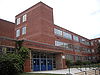
The locations of National Register properties and districts (at least for all showing latitude and longitude coordinates below), may be seen in a Google map by clicking on "Map of all coordinates".
The list is generally grouped by quadrant
Quadrants of Washington, D.C.
Washington, D.C., is administratively divided into four geographical quadrants of unequal size, each delineated by their ordinal directions from the medallion located in the Crypt under the Rotunda of the Capitol...
. The Northwest Quadrant has almost 400 listings, so is further divided into three parts. The part of the NW Quadrant nearest the National Mall is grouped with the Southwest quadrant and called "central Washington" for the purposes of this list. The following are approximate tallies of current listings by area.
Note that the White House
White House
The White House is the official residence and principal workplace of the president of the United States. Located at 1600 Pennsylvania Avenue NW in Washington, D.C., the house was designed by Irish-born James Hoban, and built between 1792 and 1800 of white-painted Aquia sandstone in the Neoclassical...
, the Capitol building
United States Capitol
The United States Capitol is the meeting place of the United States Congress, the legislature of the federal government of the United States. Located in Washington, D.C., it sits atop Capitol Hill at the eastern end of the National Mall...
, and the United States Supreme Court Building
United States Supreme Court building
The Supreme Court Building is the seat of the Supreme Court of the United States. It is situated in Washington, D.C. at 1 First Street, NE, on the block immediately east of the United States Capitol. The building is under the jurisdiction of the Architect of the Capitol. On May 4, 1987, the Supreme...
are recorded in the National Register's NRIS database as a National Historic Landmarks, but these a matter of law three buildings and associated buildings and grounds are legally exempted from listing in the National Register of Historic Places
National Register of Historic Places
The National Register of Historic Places is the United States government's official list of districts, sites, buildings, structures, and objects deemed worthy of preservation...
, according to the Historic Preservation Act of 1966, Section 107 (16 U.S.C. 470g).
Current listings by area
  |
|
  |
Central Washington
includes the SW Quadrant and areas in the NW Quadrant east of Rock Creek and south of M Street.NW quadrant
- National Register of Historic Places listings in western Washington, D.C.National Register of Historic Places listings in western Washington, D.C.This is a list of properties and districts that are listed on the National Register of Historic Places in the Northwest quadrant of Washington, D.C. which are west of Rock Creek.-Current listings:...
includes areas west of Rock Creek
- National Register of Historic Places listings in the upper NW Quadrant of Washington, D. C.National Register of Historic Places listings in the upper NW Quadrant of Washington, D. C.This is a list of properties and districts listed on the National Register of Historic Places in the Northwest quadrant of Washington, D.C. that are both east of Rock Creek and north of M Street.-Current listings:...
includes areas east of Rock Creek and north of M Street.
NE quadrant
| Landmark name | Image | Date listed | Location | Neighborhood | Summary | |
|---|---|---|---|---|---|---|
| 1 | American Revolution Statuary American Revolution Statuary American Revolution Statuary is a group of fourteen statues in Washington, D.C., listed with the National Register of Historic Places. The statues are scattered across Washington, mainly in squares and traffic circles, with four statues of European officers displayed in Lafayette Square, across... |
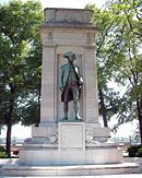 |
Public buildings and various parks within DC 38°53′37"N 76°59′59"W |
Stanton Park | 14 statues including 11 in central DC, and the General Nathanael Greene statue in Stanton Park | |
| 2 | Atlas Theater and Shops Atlas Theater and Shops The Atlas Theater and Shops are located at 1313-33 H Street, Northeast, Washington, D.C., in the Swampoodle neighborhood.-History:It was originally built in 1938, by the Kogod-Burka movie chain.It closed in August 1976.... |
1313-33 H Street, NE 38°53′59"N 76°59′15"W |
NE | |||
| 3 | Mountjoy Bayly House Hiram W. Johnson House The Hiram W. Johnson House, also known as Mountjoy Bayly House, Chaplains Memorial Building or Parkington, is a building in Washington, D.C.. It was a home of Hiram Johnson, a senator who called for the formation of the Progressive Party.... |
 |
122 Maryland Ave., NE 38°53′29"N 77°0′18"W |
NE | ||
| 4 | Brooks Mansion Brooks Mansion Brooks Mansion is a Greek Revival plantation house, and Category II Landmark. It is located at 901 Newton Street, Northeast, Washington, D.C., in the Brookland neighborhood, next to the Brookland–CUA .-History:... |
901 Newton St., NE. 38°55′58"N 76°59′37"W |
NE | |||
| 5 | Ralph Bunche House Ralph Bunche House (Washington, D.C.) Ralph Bunche House was the home Ralph Bunche commissioned from Hilyard Robinson in 1941. It is located at 1510 Jackson Street, Northeast, Washington, D.C., in the Brookland neighborhood.... |
1510 Jackson St., NE. 38°55′47"N 76°59′2"W |
NE | |||
| 6 | Capitol Hill Historic District Capitol Hill, Washington, D.C. Capitol Hill, aside from being a metonym for the United States Congress, is the largest historic residential neighborhood in Washington D.C., stretching easterly in front of the United States Capitol along wide avenues... |
 |
Roughly bounded by Virginia Ave., SE., S. Capitol St., F St. NE., and 14th Sts. SE & NE. 38°53′13"N 76°59′51"W |
NE, SE and NW | Boundary increase (listed July 3, 2003): Roughly bounded by 7th St. NE, I-295, M St. SE and 11th St. SE | |
| 7 | Chesapeake and Potomac Telephone Company Warehouse and Repair Facility Chesapeake and Potomac Telephone Company Warehouse and Repair Facility The Chesapeake and Potomac Telephone Company Warehouse and Repair Facility is an Art Deco industrial building, located at 1111 North Capitol Street, Northeast, Washington, D.C., in the NoMa neighborhood.-History:It was built in 1927.... |
1111 N. Capitol St. NE 38°54′15.48"N 77°0′32.4"W |
NE | |||
| 8 | Children's Country Home Children's Country Home The Children's Country Home, also known as the Hospital for Sick Children, is a historic building, located at 1731 Bunker Hill Road, Northeast, Washington, D.C., in the Brookland neighborhood.-History:... |
1731 Bunker Hill Rd. NE 38°56′29"N 76°58′39"W |
NE | |||
| 9 | Civil War Monuments in Washington, DC Civil War Monuments in Washington, DC Civil War Monuments in Washington, D.C. is a group of 18 statues, that are spread out through much of central and northwest Washington, D.C. The statues depict 11 Union generals, and only one Confederate general, Albert Pike, who is depicted as a Mason rather than a military man. Two Union... |
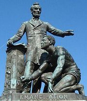 |
Various parks within the original boundaries of city 38°53′23"N 76°59′25"W |
Various | 18 statues about people and topics related to the Civil War, including 1 in Lincoln Park (NE & SE quadrants), 6 in the upper NW quadrant, and 11 in central Washington. | |
| 10 | Alexander Crummell School Alexander Crummell School The Alexander Crummell School is an Elizabethan Revival school building, located at 1900 Gallaudet Street and Kendall Street, Northeast, Washington, D.C., in the Ivy City neighborhood.-History:... |
Kendall and Gallaudet Sts, NE 38°54′48"N 76°59′7"W |
NE | |||
| 11 | Dahlgreen Courts Dahlgreen Courts Dahlgreen Courts is an historic structure located in the Brookland neighborhood in the Northeast quadrant of Washington, D.C. The complex is made up of two buildings that contain 96 units. They were listed on the National Register of Historic Places in 2010.... |
2504-2520 10th St., NE 38°55′22"N 76°59′34"W |
Brookland | Apartment Buildings in Washington, DC, MPS | ||
| 12 | East Capitol Street Carbarn | 1400 E. Capitol St., NE. 38°53′23"N 76°59′6"W |
NE | |||
| 13 | East Corner Boundary Marker of the Original District of Columbia Boundary Stones (District of Columbia) The Boundary Markers of the Original District of Columbia are the 40 milestones that mark the four lines forming the boundaries between the states of Maryland and Virginia and the square of 100 square miles of federal territory that became the District of Columbia in 1801... |
100 ft. E of jct. of Eastern and Southern Aves. 38°53′35"N 76°54′34"W |
NE and SE | See List of Boundary Markers of the Original District of Columbia | ||
| 14 | Engine Company 17 | 1227 Monroe St. NE 38°56′3"N 76°59′23"W |
NE | |||
| 15 | Engine Company 26 | 1340 Rhode Island Ave., NE 38°55′29"N 76°59′12"W |
NE | Firehouses in Washington DC MPS |
||
| 16 | Engine Company 26, (Old) | 2715 22nd St. NE 38°55′30"N 76°58′27"W |
NE | |||
| 17 | Engine Company 27 | 4201 Minnesota Ave., NE 38°54′4"N 76°56′36"W |
NE | Firehouses in Washington DC MPS | ||
| 18 | Engine House No. 10 | 1341 Maryland Ave., NE 38°53′53.99"N 76°59′12.63"W |
NE | |||
| 19 | First Baptist Church of Deanwood First Baptist Church of Deanwood First Baptist Church of Deanwood is a historic church at 1008 45th Street in Northeast, Washington, D.C., in the Deanwood neighborhood.It was built in 1938, and added to the National Register in 2008. A new church was completed in 1961, just south of the old church... |
1008 45th St. NE 38°54′11.23"N 76°56′16.8"W |
NE | |||
| 20 | Franciscan Monastery and Memorial Church of the Holy Land | 1400 Quincy St., NE. 38°56′13"N 76°59′0"W |
NE | |||
| 21 | Gallaudet College Historic District Gallaudet College Historic District Gallaudet College Historic District is a U.S. National Historic Landmark district on the campus of Gallaudet University in Washington, D.C..Gallaudet College, the main college building was listed on the National Register of Historic Places in 1966 and designated a National Historic Landmark in 1965... |
 |
and | Florida Ave. and 7th St., NE. 38°54′22"N 76°59′45"W |
NE | |
| 22 | Glenwood Cemetery Mortuary Chapel Glenwood Cemetery Mortuary Chapel Glenwood Cemetery Mortuary Chapel is a historic chapel in Northeast, Washington, D.C.It was built in 1892 and added to the National Register of Historic Places in 1989.... |
2219 Lincoln Rd., NE 38°55′19"N 77°0′22"W |
NE | |||
| 23 | Hecht Company Warehouse Hecht Company Warehouse The Hecht Company Warehouse in Washington, D.C. is a Streamline Moderne style building. Designed by engineer Gilbert V. Steel of the New York engineering firm Abbott and Merkt, and prominently located on New York Avenue, it served as the central warehouse for The Hecht Company from its... |
 |
1401 New York Ave., NE. 38°54′52"N 76°59′6"W |
NE | ||
| 24 | Kenilworth Aquatic Gardens Kenilworth Park and Aquatic Gardens Kenilworth Park & Aquatic Gardens is a National Park Service site located in the north eastern corner of Washington, D.C., and the Maryland state border. Nestled near the banks of the Anacostia River and directly south of the Baltimore Washington Parkway, Kenilworth Park & Aquatic Gardens preserves... |
 |
Kenilworth Ave. and Douglas St. NE 38°54′46"N 76°56′37"W |
NE | ||
| 25 | Langston Golf Course Historic District Langston Golf Course Langston Golf Course is an 18-hole golf course in Washington, D.C., established in 1939. It was named for John Mercer Langston, an African American who was the first dean of the Howard University School of Law, the first president of Virginia Normal and Collegiate Institute , and the first African... |
Roughly, Anacostia Park N of Benning Rd. NE 38°54′8"N 76°57′54"W |
NE | |||
| 26 | Langston Terrace Dwellings Langston Terrace Dwellings Langston Terrace Dwellings are historic structures located in the Kingman Park neighborhood in the Northeast quadrant of Washington, D.C. The apartments were built between 1935 and 1938 and they were listed on the National Register of Historic Places in 1987.... |
N from Benning Rd. to H St., NE 38°53′58"N 76°58′26"W |
Kingman Park Kingman Park, Washington, D.C. Kingman Park is a residential neighborhood in the Northeast quadrant of Washington, D.C., the capital city of the United States. Kingman Park's boundaries are 15th Street NE to the west; C Street SE to the south; Benning Road to the north; and Anacostia Park to the east... |
|||
| 27 | Mayfair Mansions Apartments Mayfair Mansions Apartments Mayfair Mansions Apartments are historic structures located in the Mayfair neighborhood of the Northeast quadrant of Washington, D.C. The garden apartments were built between 1942 and 1946 and they were listed on the National Register of Historic Places in 1989.-History:Mayfair Mansions were the... |
3819 Jay St., NE 38°54′11"N 76°56′55"W |
Mayfair Mayfair, Washington, D.C. Mayfair is a residential neighborhood in Northeast Washington, D.C, United States., on the eastern bank of the Anacostia River. It is bounded by Jay Street NE on the north, Foote Street on the south, Kenilworth Terrace and Anacostia Avenue on the west, and Kenilworth Avenue on the east. Mayfair is... |
|||
| 28 | Newton Theater Newton Theater The Newton Theater is located at 3601 12th Street, Northeast, Washington, D.C., in the Brookland neighborhoodThe Art Deco building was designed by John Jacob Zink in 1937.... |
3601-3611 12th St. NE 38°56′8"N 76°59′27"W |
NE | |||
| 29 | Northeast No. 3 Boundary Marker of the Original District of Columbia Boundary Stones (District of Columbia) The Boundary Markers of the Original District of Columbia are the 40 milestones that mark the four lines forming the boundaries between the states of Maryland and Virginia and the square of 100 square miles of federal territory that became the District of Columbia in 1801... |
144 ft. NW of jct. of Eastern Ave. and Chillum Rd. 38°57′17"N 76°59′17"W |
NE | |||
| 30 | Northeast No. 4 Boundary Marker of the Original District of Columbia Boundary Stones (District of Columbia) The Boundary Markers of the Original District of Columbia are the 40 milestones that mark the four lines forming the boundaries between the states of Maryland and Virginia and the square of 100 square miles of federal territory that became the District of Columbia in 1801... |
5400 Sargent Rd. 38°57′17"N 76°59′17"W |
NE | |||
| 31 | Northeast No. 5 Boundary Marker of the Original District of Columbia Boundary Stones (District of Columbia) The Boundary Markers of the Original District of Columbia are the 40 milestones that mark the four lines forming the boundaries between the states of Maryland and Virginia and the square of 100 square miles of federal territory that became the District of Columbia in 1801... |
4609 Eastern Ave. 38°56′39"N 76°58′28"W |
NE | |||
| 32 | Northeast No. 6 Boundary Marker of the Original District of Columbia Boundary Stones (District of Columbia) The Boundary Markers of the Original District of Columbia are the 40 milestones that mark the four lines forming the boundaries between the states of Maryland and Virginia and the square of 100 square miles of federal territory that became the District of Columbia in 1801... |
3601 Eastern Ave. 38°56′1"N 76°57′41"W |
NE | |||
| 33 | Northeast No. 7 Boundary Marker of the Original District of Columbia Boundary Stones (District of Columbia) The Boundary Markers of the Original District of Columbia are the 40 milestones that mark the four lines forming the boundaries between the states of Maryland and Virginia and the square of 100 square miles of federal territory that became the District of Columbia in 1801... |
Ft. Lincoln Cemetery 38°55′26"N 76°56′56"W |
NE | |||
| 34 | Northeast No. 8 Boundary Marker of the Original District of Columbia Boundary Stones (District of Columbia) The Boundary Markers of the Original District of Columbia are the 40 milestones that mark the four lines forming the boundaries between the states of Maryland and Virginia and the square of 100 square miles of federal territory that became the District of Columbia in 1801... |
Kenilworth Aquatics Gardens, NW of jct. of Eastern and Kenilworth Aves. 38°54′50"N 76°56′10"W |
NE | |||
| 35 | Northeast No. 9 Boundary Marker of the Original District of Columbia Boundary Stones (District of Columbia) The Boundary Markers of the Original District of Columbia are the 40 milestones that mark the four lines forming the boundaries between the states of Maryland and Virginia and the square of 100 square miles of federal territory that became the District of Columbia in 1801... |
919 Eastern Ave. 38°54′12"N 76°55′21"W |
NE | |||
| 36 | Plymouth Theater H Street Playhouse The H Street Playhouse is a black-box theater and gallery located in the Atlas District, in Northeast Washington D.C. Home to resident companies , and Forum Theatre , the Playhouse has also hosted African Continuum Theatre Company, Musefire, Landless Theater Company, Theater Blue, Journeymen... |
1365 H St., NE 38°54′7"N 76°59′11"W |
NE | |||
| 37 | President's House, Gallaudet College President's House, Gallaudet College The President's House, Gallaudet College was built in 1869. It is on the campus of Gallaudet University. It was listed on the National Register of Historic Places in 1974.... |
7th St. and Florida Ave., NE. 38°54′19"N 76°59′46"W |
NE | |||
| 38 | Roosevelt Apartment Building Roosevelt Apartment Building The Roosevelt Apartment Building is an historic structure located in the Capitol Hill neighborhood in the Northeast quadrant of Washington, D.C. The building is a multiple-family double row-house that was built as a middle-class dwelling. C. Graham, & Son designed the Late Victorian building,... |
1116-1118 F St., NE. 38°53′50"N 76°59′27"W |
NE | |||
| 39 | Sewall-Belmont House National Historic Site | 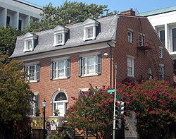 |
144 Constitution Ave., NE. 38°53′31"N 77°0′15"W |
NE | ||
| 40 | Strand Theater Strand Theater (Washington, D.C.) The Strand Theater is an abandoned neighborhood movie theater, located at 5129–5131 Nannie Helen Burroughs Avenue, Northeast, Washington, D.C., in the Deanwood neighborhood.-History:Abe E... |
5129-5131 Nannie Helen Burroughs Ave., NE 38°53′53.99"N 76°55′33.95"W |
NE | |||
| 41 | Trades Hall of National Training School for Women and Girls Nannie Helen Burroughs School Nannie Helen Burroughs School, formerly known as National Training School for Women and Girls, is a private coeducational elementary school located in the District of Columbia. The school was originally founded in 1909 by Nannie Helen Burroughs as The National Trade and Professional School for... |
 |
601 50th St., NE. 38°53′46"N 76°55′48"W |
NE | ||
| 42 | Truck House No. 13 | 1342 Florida Ave. NE 38°54′5"N 76°59′13"W |
NE | |||
| 43 | U.S. National Arboretum United States National Arboretum The United States National Arboretum is an arboretum in Washington, D.C., operated by the United States Department of Agriculture's Agricultural Research Service as a division of the Henry A. Wallace Beltsville Agricultural Research Center... |
|
24th and R Sts., NE. 38°54′42"N 76°57′58"W |
NE | ||
| 44 | Uline Ice Company Plant and Arena Complex | 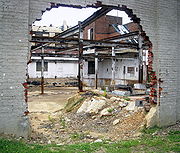 |
1132, 1140, and 1146 3rd St. NE 38°54′18"N 77°0′11"W |
NE | ||
| 45 | Union Station Union Station (Washington, D.C.) Washington Union Station is a train station and leisure destination visited by 32 million people each year in the center of Washington, D.C. The train station is served by Amtrak, MARC and Virginia Railway Express commuter rail services as well as by Washington Metro subway trains and local buses... |
Intersection of Massachusetts and Louisiana Aves. and 1st St., NE. 38°53′51"N 77°0′23"W |
NE | |||
| 46 | Union Station Plaza and Columbus Fountain Columbus Fountain Columbus Fountain is a public artwork by American sculptor Lorado Taft, located at Union Station in Washington, D.C., United States. This sculpture was surveyed in 1994 as part of the Smithsonian's Save Outdoor Sculpture! program... |
1st St., Massachusetts and Louisiana Aves., NE 38°53′47"N 77°0′23"W |
NE | |||
| 47 | United Brick Corporation Brick Complex United Brick Corporation Brick Complex The United Brick Corporation Brick Complex, also known as the New York Avenue Brick Kilns, is an historic industrial site. It is located at 2801 New York Avenue, Northeast, Washington, D.C... |
2801 New York Ave., NE. 38°54′58"N 76°58′6"W |
NE | |||
| 48 | Woodward & Lothrop Service Warehouse Woodward & Lothrop Service Warehouse The Woodward & Lothrop Service Warehouse is a historic warehouse located in the NoMa neighborhood of Washington, D.C. It was designated a District of Columbia Historic Landmark in 1993, and was added to the National Register of Historic Places in 2005... |
131 M St. NE 38°54′25"N 77°0′17"W |
NE |
SE quadrant
| Landmark name | Image | Date listed | Location | Neighborhood | Summary | |
|---|---|---|---|---|---|---|
| 1 | Anacostia Historic District Anacostia Historic District The Anacostia Historic District is a historic district in the city of Washington, D.C., comprising approximately 20 squares and about 550 buildings built between 1854 and 1930. The Anacostia Historic District was added to the National Register of Historic Places in 1978. "The architectural... |
 |
Roughly bounded by Martin Luther King, Jr. Avenue; Good Hope Road; 16th Street; Fendall Street; V Street; 15th Street and the Frederick Douglass National Historic Site; Maple View Place 38°51′53"N 76°59′8"W |
SE | Comprises approximately 20 squares and about 550 buildings built between 1854 and 1930 | |
| 2 | Capitol Hill Historic District | |
Roughly bounded by Virginia Ave., SE., S. Capitol St., F St. NE., and 14th Sts. SE & NE. 38°53′13"N 76°59′51"W |
NE, SE and NW | Boundary increase (listed July 3, 2003): Roughly bounded by 7th St. NE, I-295, M St. SE and 11th St. SE | |
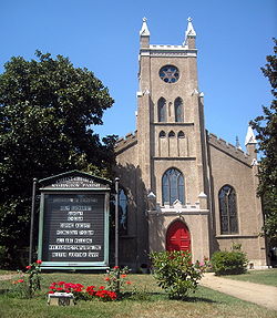
| 3 | Christ Church | |
620 G St., SE. 38°52′53"N 76°59′52"W |
SE | ||
| 4 | Civil War Monuments in Washington, DC Civil War Monuments in Washington, DC Civil War Monuments in Washington, D.C. is a group of 18 statues, that are spread out through much of central and northwest Washington, D.C. The statues depict 11 Union generals, and only one Confederate general, Albert Pike, who is depicted as a Mason rather than a military man. Two Union... |
|
Various parks within the original boundaries of city 38°53′23"N 76°59′25"W |
Various | 18 statues about people and topics related to the Civil War, including 1 in Lincoln Park (NE & SE quadrants), 6 in the upper NW quadrant, and 11 in central Washington. | |
| 5 | Commandant's Office, Washington Navy Yard Commandant's Office, Washington Navy Yard The Commandant's Office in the Washington Navy Yard, also known as Building One, Quarters J, or the Middendorf Building is the U.S. Navy's oldest active office building, which historically housed the offices of the Commandant and other officers of the Washington Navy Yard in Washington, D.C... |
Montgomery Sq. and Dahlgren Ave., SE. 38°52′23"N 76°59′43"W |
SE | See Washington Navy Yard Washington Navy Yard The Washington Navy Yard is the former shipyard and ordnance plant of the United States Navy in Southeast Washington, D.C. It is the oldest shore establishment of the U.S. Navy... Small building at bottom of photo |
||
| 6 | Congressional Cemetery Congressional Cemetery The Congressional Cemetery is a historic cemetery located at 1801 E Street, SE, in Washington, D.C., on the west bank of the Anacostia River. It is the final resting place of thousands of individuals who helped form the nation and the city of Washington in the early 19th century. Many members of... |
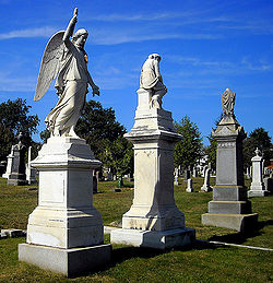 |
1801 E St., SE. 38°52′52"N 76°58′38"W |
SE | Designated a National Historic Landmark June 14, 2011 | |
| 7 | Frederick Douglass National Historic Site Frederick Douglass National Historic Site The Frederick Douglass National Historic Site, administered by the National Park Service, is located at 1411 W St., SE in Anacostia, a neighborhood east of the Anacostia River in Southeast Washington, D.C.. Established in 1988 as a National Historic Site, the site preserves the home and estate of... |
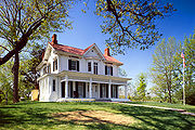 |
1411 W St., SE. 38°51′45"N 76°59′4"W |
SE | ||
| 8 | Eastern Market Eastern Market, Washington, D.C. The Eastern Market is a public market in the Capitol Hill neighborhood of Washington, D.C., housed in a 19th century brick building. It is located on 7th Street SE, a few blocks east of the U.S. Capitol between North Carolina Avenue SE and C Street SE. The Eastern Market is on the National... |
7th and C Sts., SE. 38°53′11"N 76°59′48"W |
SE | Badly damaged by an early-morning fire on April 30, 2007; reopened on June 26, 2009 | ||
| 9 | East Corner Boundary Marker of the Original District of Columbia | 100 ft. E of jct. of Eastern and Southern Aves. 38°53′35"N 76°54′34"W |
NE and SE | See List of Boundary Markers of the Original District of Columbia | ||
| 10 | Engine Company No. 19 | 2813 Pennsylvania Ave., SE 38°52′24"N 76°58′1"W |
SE | |||
| 11 | Engine Company No. 25 | 3203 Martin Luther King Jr., Ave SE 38°50′35"N 77°0′3"W |
SE | |||
| 12 | Folger Shakespeare Library Folger Shakespeare Library The Folger Shakespeare Library is an independent research library on Capitol Hill in Washington, D.C., in the United States. It has the world's largest collection of the printed works of William Shakespeare, and is a primary repository for rare materials from the early modern period... |
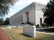 |
201 E. Capitol St., SE. 38°53′22"N 77°0′11"W |
SE | ||
| 13 | Friendship House Friendship House (Washington, D.C.) Friendship House is a Georgian townhouse, located at 619 D Street, , Southeast, Washington, D.C., in the Capitol Hill neighborhood.-History:... |
619 D St., SE., or 630 South Carolina Ave., SE. 38°53′2"N 76°59′53"W |
SE | |||
| 14 | Gallinger Municipal Hospital Psychopathic Ward | Reservation 13, 19th St. and Massachusetts Ave., SE 38°53′4"N 76°58′37"W |
SE | |||
| 15 | Main Gate, Washington Navy Yard Latrobe Gate The Latrobe Gate is a historic gatehouse located at the Washington Navy Yard in Southeast Washington, D.C. Built in 1806 and substantially altered in 1881, the ceremonial entrance to the U.S. Navy's oldest shore establishment is an example of Greek Revival and Italianate architecture... |
 |
8th and M Sts., SE. 38°52′35"N 76°59′43"W |
SE | More commonly known as the Latrobe Gate Latrobe Gate The Latrobe Gate is a historic gatehouse located at the Washington Navy Yard in Southeast Washington, D.C. Built in 1806 and substantially altered in 1881, the ceremonial entrance to the U.S. Navy's oldest shore establishment is an example of Greek Revival and Italianate architecture... . |
|
| 16 | Old Naval Hospital Old Naval Hospital The Old Naval Hospital is a historic building located at 921 Pennsylvania Avenue, Southeast Washington, D.C., in the Capitol Hill neighborhood.-History:In March 1864, president Abraham Lincoln asked Congress to construct the Hospital... |
921 Pennsylvania Ave., SE. 38°52′58"N 76°59′36"W |
SE | |||
| 17 | Quarters A, Washington Navy Yard | E of Main Gate and S of M St., SE., in the Navy Yard 38°52′34"N 76°59′41"W |
SE | |||
| 18 | Quarters B, Washington Navy Yard | Charles Morris Ave., SE. 38°52′32"N 76°59′39"W |
SE | |||
| 19 | St. Elizabeths Hospital St. Elizabeths Hospital St. Elizabeths Hospital is a psychiatric hospital operated by the District of Columbia Department of Mental Health. It was the first large-scale, federally-run psychiatric hospital in the United States. Housing several thousand patients at its peak, St. Elizabeths had a fully functioning... |
1100 Alabama Avenue SE. 38°51′1"N 76°59′40"W |
SE | |||
| 20 | St. Mark's Church St. Mark's Episcopal Church (Washington, D.C.) St. Mark's Episcopal Church, also known as St. Mark's, Capitol Hill, is a historic Episcopal church located at 3rd and A Streets, Southeast in the Capitol Hill neighborhood of Washington, D.C.. Built 1888–1894, the church is an example of Gothic Revival and Romanesque Revival... |
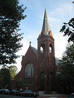 |
3rd and A Sts., SE. 38°53′18"N 77°0′6"W |
SE | ||
| 21 | Saint Paul African Union Methodist Church Saint Paul African Union Methodist Church Saint Paul African Union Methodist Church is an historic structure located in the Navy Yard section of Washington, D.C., United States. It is the only congregation in the District of Columbia of the oldest incorporated, independent African- American denomination in the country... |
401 I St., SE. 38°52′45"N 77°0′2"W |
SE | |||
| 22 | John Philip Sousa Junior High School John Philip Sousa Junior High School John Philip Sousa Junior High School, also known as John Philip Sousa Middle School. is located in SE area of Washington, D.C..In 1950, eleven black students were denied admission to the newly constructed all-white Sousa school. This action was eventually overturned in the landmark 1954 Supreme... |
 |
3650 Ely Place, SE 38°53′0.59"N 76°57′7.98"W |
SE | In 1950, eleven African American African American African Americans are citizens or residents of the United States who have at least partial ancestry from any of the native populations of Sub-Saharan Africa and are the direct descendants of enslaved Africans within the boundaries of the present United States... students were denied admission to the newly constructed all-white Sousa school. This action was eventually overturned in the landmark 1954 Supreme Court Supreme Court of the United States The Supreme Court of the United States is the highest court in the United States. It has ultimate appellate jurisdiction over all state and federal courts, and original jurisdiction over a small range of cases... decision in Bolling v. Sharpe Bolling v. Sharpe Bolling v. Sharpe, 347 U.S. 497 , is a landmark United States Supreme Court case which deals with civil rights, specifically, segregation in the District of Columbia's public schools. Originally argued on December 10–11, 1952, a year before Brown v. Board of Education, 347 U.S... , which made segregated Racial segregation Racial segregation is the separation of humans into racial groups in daily life. It may apply to activities such as eating in a restaurant, drinking from a water fountain, using a public toilet, attending school, going to the movies, or in the rental or purchase of a home... public schools illegal in the District of Columbia. This defeat of the principle of "separate but equal Separate but equal Separate but equal was a legal doctrine in United States constitutional law that justified systems of segregation. Under this doctrine, services, facilities and public accommodations were allowed to be separated by race, on the condition that the quality of each group's public facilities was to... " was a significant landmark in the modern Civil Rights Movement African-American Civil Rights Movement (1955-1968) The African-American Civil Rights Movement refers to the movements in the United States aimed at outlawing racial discrimination against African Americans and restoring voting rights to them. This article covers the phase of the movement between 1955 and 1968, particularly in the South... . |
|
| 23 | Southeast No. 1 Boundary Marker of the Original District of Columbia | 30 ft. south of the junction of Southern Ave. and D St., SE 38°52′58.03"N 76°55′20.29"W |
SE | |||
| 24 | Southeast No. 2 Boundary Marker of the Original District of Columbia | 4345 Southern Ave. 38°52′20"N 76°56′9"W |
SE | |||
| 25 | Southeast No. 3 Boundary Marker of the Original District of Columbia | 3908 Southern Ave. 38°51′43"N 76°56′55"W |
SE | |||
| 26 | Southeast No. 5 Boundary Marker of the Original District of Columbia | 280 ft. NE of jct. of Southern Ave. and Valley Terrace 38°50′31"N 76°58′29"W |
SE | |||
| 27 | Southeast No. 6 Boundary Marker of the Original District of Columbia | 901 Southern Ave. 38°49′54"N 76°59′17"W |
SE | |||
| 28 | Southeast No. 7 Boundary Marker of the Original District of Columbia | 25 ft. NE of jct. of Southern Ave. and Indian Head Rd. 38°49′17"N 77°0′5"W |
SE | |||
| 29 | Southeast No. 9 Boundary Marker of the Original District of Columbia | .225 mi. S of Oxon Cove Br. and 420 ft. E of Shepherd Pkwy. 38°48′14"N 77°1′27"W |
SE | |||
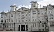
| 30 | U.S. Marine Corps Barracks and Commandant's House Marine Barracks, Washington, D.C. Marine Barracks, Washington, D.C. is located at 8th and I Streets, Southeast in Washington, D.C. Established in 1801, it is a National Historic Landmark, the oldest post in the United States Marine Corps, the official residence of the Commandant of the Marine Corps since 1806, and main ceremonial... |
 |
8th and I Sts., SE 38°52′48"N 76°59′41"W |
SE | ||
| 31 | Suitland Parkway Suitland Parkway The Suitland Parkway is a parkway in Washington, D.C., and Prince George's County, Maryland, maintained by the U.S. National Park Service. Conceived in 1937, it was built during World War II to provide a road connection between military facilities in the Washington, D.C., metropolitan area, and... |
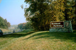 |
From the Anacostia R. in the District of Columbia to Pennsylvania Ave. in Prince George's County, Maryland 38°50′29"N 76°55′17"W |
SE | ||
| 32 | Washington and Georgetown Railroad Car House Washington and Georgetown Railroad Car House The Washington and Georgetown Railroad Car House, also known as the Navy Yard Car Barn, or Blue Castle, is an historic building, located at 770 M Street, Southeast, Washington, D.C.The Romanesque Revival building was designed by Walter C... |
770 M St. SE 38°52′44"N 76°59′45"W |
SE | Commonly known as the Blue Castle | ||
| 33 | Washington Navy Yard Washington Navy Yard The Washington Navy Yard is the former shipyard and ordnance plant of the United States Navy in Southeast Washington, D.C. It is the oldest shore establishment of the U.S. Navy... |
 |
8th and M Sts., SE 38°52′25"N 76°59′47"W |
SE | ||
| 34 | Watterston House Watterston House Watterson House is a Federal rowhouse, located at 224 2nd Street, Southeast, Washington, D.C., on Capitol Hill.It was placed on the National Register of Historic Places on January 17, 1992.It was named for George Watterston, a Librarian of Congress.... |
224 2nd St., SE. 38°53′11"N 77°0′13"W |
SE | |||
| 35 | Woodlawn Cemetery Woodlawn Cemetery (Washington, D.C.) Woodlawn Cemetery is a historic cemetery in Washington, D.C.. It occupies approximately 22.5 acres in southeast DC. Founded in 1895, it was closed in 1970.Buried there are many prominent Americans, including Blanche Kelso Bruce, a U.S... |
4611 Benning Rd., SE 38°53′6"N 76°56′19"W |
SE |