
List of Registered Historic Places in Queens County, New York
Encyclopedia
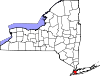
List of the National Register of Historic Places listings in Queens County, New York
This is intended to be a complete list of properties and districts listed on the National Register of Historic Places
National Register of Historic Places
The National Register of Historic Places is the United States government's official list of districts, sites, buildings, structures, and objects deemed worthy of preservation...
in Queens County, New York
Queens
Queens is the easternmost of the five boroughs of New York City. The largest borough in area and the second-largest in population, it is coextensive with Queens County, an administrative division of New York state, in the United States....
. The locations of National Register properties and districts (at least for all showing latitude and longitude coordinates below) may be seen in a Google map by clicking on "Map of all coordinates". Four of the properties are further designated as U.S. National Historic Landmarks.
Listings county-wide
| Landmark name | Image | Date listed | Location | City or Town | Summary | |
|---|---|---|---|---|---|---|
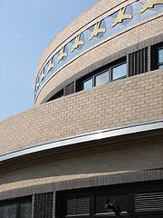
| 1 | 1964-1965 New York World's Fair New York State Pavilion 1964-1965 New York World's Fair New York State Pavilion 1964-1965 New York World's Fair New York State Pavilion is a historic world's fair pavilion at Flushing Meadows – Corona Park in Flushing, Queens, New York. The New York State Pavilion was designed and built between 1962 and 1964. It was designed by famed modernist architect Philip Johnson... |
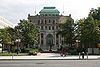
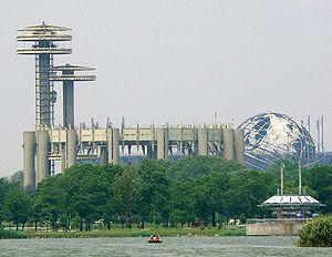 |
Flushing Meadows – Corona Park 40°44′38.5"N 73°50′39.9"W |
Flushing Flushing, Queens Flushing, founded in 1645, is a neighborhood in the north central part of the City of New York borough of Queens, east of Manhattan.Flushing was one of the first Dutch settlements on Long Island. Today, it is one of the largest and most diverse neighborhoods in New York City... |
||
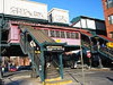
| 2 | 45th Road – Court House Square Subway station ( trains) |  |
Above 23rd St. bet. 44th Dr. and 45ht Rd. 40°44′47"N 73°56′45"W |
Long Island City Long Island City, Queens Long Island City is the westernmost neighborhood of the borough of Queens in New York City. L.I.C. is notable for its rapid and ongoing gentrification, its waterfront parks, and its thriving arts community. L.I.C. has among the highest concentration of art galleries, art institutions, and studio... |
||
| 3 | 68th Avenue-64th Place Historic District 68th Avenue-64th Place Historic District 68th Avenue-64th Place Historic District is a national historic district in Ridgewood, Queens, New York. It includes 46 contributing buildings built between 1909 and 1913. They consist mainly of two story brick row houses with one apartment per floor... |
Roughly 64th Pl. from Catalpa Ave. to 68th Ave. from 64th St. to 65th St. 40°42′20"N 73°53′40"W |
Ridgewood Ridgewood, Queens Ridgewood is a neighborhood in the New York City borough of Queens. It borders the neighborhoods of Maspeth, Middle Village and Glendale, as well as the Brooklyn neighborhood of Bushwick. Historically, the neighborhood straddled the Queens-Brooklyn boundary. The neighborhood is part of Queens... |
|||
| 4 | 75th Avenue-61st Street Historic District 75th Avenue-61st Street Historic District 75th Avenue-61st Street Historic District is a national historic district in Ridgewood, Queens, New York. It includes 183 contributing buildings built between 1910 and 1925. They consist mainly of two story brick row houses with one apartment per floor... |
Roughly bounded by St. Felix Ave., 60th Lane, 60th and 62nd Sts. 40°41′55"N 73°53′41"W |
Ridgewood Ridgewood, Queens Ridgewood is a neighborhood in the New York City borough of Queens. It borders the neighborhoods of Maspeth, Middle Village and Glendale, as well as the Brooklyn neighborhood of Bushwick. Historically, the neighborhood straddled the Queens-Brooklyn boundary. The neighborhood is part of Queens... |
|||
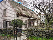
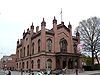
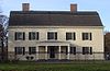
| 5 | Allen-Beville House Allen-Beville House The Allen-Beville House was constructed between 1848-1850. The house is in the Douglaston section of the borough of Queens in New York City. It is one of the few surviving 19th century structures in Queens built as a farmhouse that survives.... |
29 Center Dr. 40°46′22"N 73°45′3"W |
Douglaston Douglaston, Queens Douglaston, population 14,168 , is a community in the New York City borough of Queens. Douglaston comprises six distinct neighborhoods: Doug Bay, Douglas Manor, and Douglaston Hill, all located north of Northern Boulevard on the peninsula abutting Little Neck Bay; Douglaston Park, located between... |
|||
| 6 | Louis Armstrong House Louis Armstrong House The Louis Armstrong House was the home of Louis Armstrong and his wife Lucille between 1943 and 1971 when he died. Lucille gave it to the city in order to create a museum focused on her husband... |
 |
3456 107th St. 40°45′20"N 73°51′43"W |
Corona Corona, Queens Corona is a densely-populated neighborhood in the former Township of Newtown in the borough of Queens in New York City, New York, United States... |
||
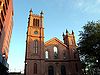
| 7 | Astoria Center of Israel Astoria Center of Israel The Astoria Center of Israel is an historic synagogue located in the Astoria, Queens neighborhood of New York City, listed on both the New York State and the National Registers of Historic Places.-Design:... |
27-35 Crescent St. 40°46′12.79"N 73°55′25.58"W |
Astoria Astoria, Queens Astoria is a neighborhood in the northwestern corner of the borough of Queens in New York City. Located in Community Board 1, Astoria is bounded by the East River and is adjacent to three other Queens neighborhoods: Long Island City, Sunnyside , and Woodside... |
|||
| 8 | Bohemian Hall and Park Bohemian Citizens' Benevolent Society The Bohemian Citizens' Benevolent Society is a private benevolent society founded in 1892 in Astoria, Queens to support Czech and Slovak immigrants to the area, as well as people of Czech and Slovak ancestry... |
 |
29-19 24th Ave. 40°46′22"N 73°54′59"W |
Astoria Astoria, Queens Astoria is a neighborhood in the northwestern corner of the borough of Queens in New York City. Located in Community Board 1, Astoria is bounded by the East River and is adjacent to three other Queens neighborhoods: Long Island City, Sunnyside , and Woodside... |
||
| 9 | John Bowne House John Bowne House The John Bowne House is an historic home located in Flushing, Queens, New York.Built around 1661, it was the location of a Quaker meeting in 1662 that resulted in the arrest of its owner, John Bowne. Since 1947, Bowne House has been a museum.... |
 |
37-01 Bowne St. 40°45′46"N 73°49′32"W |
Flushing Flushing, Queens Flushing, founded in 1645, is a neighborhood in the north central part of the City of New York borough of Queens, east of Manhattan.Flushing was one of the first Dutch settlements on Long Island. Today, it is one of the largest and most diverse neighborhoods in New York City... |
||
| 10 | Broadway-Flushing Historic District Broadway-Flushing, Queens Broadway-Flushing or "North Flushing", is a residential section of Flushing, Queens in New York City. The neighborhood comprises approximately 2,300 homes... |
Roughly bounded by 29th Ave., 163rd St., 32nd Ave., 192nd St., 154th and 153rd Sts. 40°46′0"N 73°48′5"W |
Flushing Flushing, Queens Flushing, founded in 1645, is a neighborhood in the north central part of the City of New York borough of Queens, east of Manhattan.Flushing was one of the first Dutch settlements on Long Island. Today, it is one of the largest and most diverse neighborhoods in New York City... |
|||
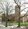
| 11 | Ralph Bunche House Ralph Johnson Bunche House Ralph Johnson Bunche House, a home of American diplomat Ralph Bunche,is a National Historic Landmark located in the Kew Gardens neighborhood of Queens, New York. It is located at 115-24 Grosvenor Road. Ralph Bunche helped found the United Nations, and this was his home for more than 30 years,... |
 |
115-125 Grosvenor Rd. 40°42′25"N 73°50′16"W |
Kew Gardens Kew Gardens, Queens Kew Gardens is a triangular-shaped neighborhood in central Queens bounded to the north by the Jackie Robinson Parkway , to the east by Van Wyck Expressway and 131st Street, to the south by Hillside Avenue, and to the west by Park Lane, Abingdon Road and 118th Street... |
||
| 12 | Central Avenue Historic District Central Avenue Historic District (Queens, New York) Central Avenue Historic District is a national historic district in Ridgewood, Queens, New York. It includes 104 contributing buildings built in 1916. They consist of three story brick tenements with two apartments per floor. Buildings feature front facades and amber iron-spot brick.It was... |
Roughly bounded by Myrtle and 70th Ave., and 65th and 66th Sts. 40°42′10"N 73°53′25"W |
Ridgewood Ridgewood, Queens Ridgewood is a neighborhood in the New York City borough of Queens. It borders the neighborhoods of Maspeth, Middle Village and Glendale, as well as the Brooklyn neighborhood of Bushwick. Historically, the neighborhood straddled the Queens-Brooklyn boundary. The neighborhood is part of Queens... |
|||
| 13 | Central Ridgewood Historic District Central Ridgewood Historic District Central Ridgewood Historic District is a national historic district in Ridgewood, Queens, New York. It includes 782 contributing buildings built between 1895 and 1927. They consist mainly of two story, brick rowhouse dwellings with one apartment per floor... |
Roughly bounded by Fresh Pond Rd., Putnam, 68th, Forest, Catalpa, Onderdonk, and 71st Aves. 40°42′10"N 73°53′57"W |
Ridgewood Ridgewood, Queens Ridgewood is a neighborhood in the New York City borough of Queens. It borders the neighborhoods of Maspeth, Middle Village and Glendale, as well as the Brooklyn neighborhood of Bushwick. Historically, the neighborhood straddled the Queens-Brooklyn boundary. The neighborhood is part of Queens... |
|||
| 14 | The Church-in-the-Gardens | 50 Ascan Ave. 40°42′55.13"N 73°50′33.05"W |
Forest Hills Forest Hills, Queens Forest Hills is a neighborhood in the borough of Queens in New York City, New York, United States.-Neighborhood:The neighborhood is home to upper-middle class residents, of whom the wealthier residents often live in the neighborhood's Forest Hills Gardens area... |
New listing; refnum 09001086 | ||
| 15 | Church of the Resurrection Church of the Resurrection (Kew Gardens, Borough of Queens, New York) The Church of the Resurrection is a historic Episcopal church and rectory in Richmond Hill, Queens, New York, New York. It was originally built in 1874 as a frame, Gothic Revival style church. It was extensively remodeled and enlarged in 1904 in the Late Gothic / Tudor Revival style. It has an... |
85-09 118th St. 40°42′8.2476"N 73°49′56.7114"W |
Kew Gardens Kew Gardens, Queens Kew Gardens is a triangular-shaped neighborhood in central Queens bounded to the north by the Jackie Robinson Parkway , to the east by Van Wyck Expressway and 131st Street, to the south by Hillside Avenue, and to the west by Park Lane, Abingdon Road and 118th Street... /Richmond Hill Richmond Hill, Queens Richmond Hill is a neighborhood in central-southern Queens, New York City, USA. It is bordered by Kew Gardens to the north, Woodhaven and Ozone Park to the west, South Ozone Park to the south and South Jamaica to the east... |
|||
| 16 | Congregation Tifereth Israel | 109-18 and 109-20 54th Ave. 40°44′32"N 73°51′12"W |
Corona Corona, Queens Corona is a densely-populated neighborhood in the former Township of Newtown in the borough of Queens in New York City, New York, United States... |
|||
| 17 | Cooper Avenue Row Historic District Cooper Avenue Row Historic District Cooper Avenue Row Historic District is a national historic district in Ridgewood, Queens, New York. It includes seven contributing buildings built in 1915. They consist of two story, flat front brick rowhouse dwellings with one apartment per floor. They are constructed of yellow brick with burnt... |
6434-6446 Cooper Ave. 40°41′53"N 73°53′27"W |
Ridgewood Ridgewood, Queens Ridgewood is a neighborhood in the New York City borough of Queens. It borders the neighborhoods of Maspeth, Middle Village and Glendale, as well as the Brooklyn neighborhood of Bushwick. Historically, the neighborhood straddled the Queens-Brooklyn boundary. The neighborhood is part of Queens... |
|||
| 18 | Cornelia-Putnam Historic District Cornelia-Putnam Historic District Cornelia-Putnam Historic District is a national historic district in Ridgewood, Queens, New York. It includes 87 contributing buildings built between 1907 and 1922. They consist of two story, flat front brick rowhouse dwellings with one apartment per floor and three story tenements with two... |
Roughly bounded by Jefferson St., Putnam, Wyckoff, and Myrtle Aves. 40°41′56"N 73°54′27"W |
Ridgewood Ridgewood, Queens Ridgewood is a neighborhood in the New York City borough of Queens. It borders the neighborhoods of Maspeth, Middle Village and Glendale, as well as the Brooklyn neighborhood of Bushwick. Historically, the neighborhood straddled the Queens-Brooklyn boundary. The neighborhood is part of Queens... |
|||
| 19 | Cornell Farmhouse Cornell Farmhouse The Cornell Farmhouse was built in 1750 with Dutch and English architectural features. The Farmhouse is in the Glen Oaks section the New York City borough of Queens. It is also known as the Creedmoor Farmhouse Complex, and as the Adriance Farmhouse... |
73-50 Little Neck Pkwy 40°44′54"N 73°43′14"W |
Floral Park Floral Park, Queens Floral Park is a neighborhood in the New York City borough of Queens. It is adjacent to the Village of Floral Park, which is in Nassau County. It may be distinguished from the latter by the use of the designation "North Floral Park". The neighborhood is part of Queens Community Board 13.Union... |
|||
| 20 | Cypress Avenue East Historic District Cypress Avenue East Historic District Cypress Avenue East Historic District is a national historic district in Ridgewood, Queens, New York. It includes 247 contributing buildings built between 1900 and 1914. They consist mainly of three story tenements with two apartments per floor... |
Roughly bounded by Linden and Cornelia Sts., Seneca and St. Nicholas Aves. 40°42′6"N 73°54′31"W |
Ridgewood Ridgewood, Queens Ridgewood is a neighborhood in the New York City borough of Queens. It borders the neighborhoods of Maspeth, Middle Village and Glendale, as well as the Brooklyn neighborhood of Bushwick. Historically, the neighborhood straddled the Queens-Brooklyn boundary. The neighborhood is part of Queens... |
|||
| 21 | Cypress Avenue West Historic District Cypress Avenue West Historic District Cypress Avenue West Historic District is a national historic district in Ridgewood, Queens, New York. It includes 440 contributing buildings built between 1888 and 1906. They consist mainly of brick two and three story row houses with one apartment per floor and three story tenements with two... |
Roughly bounded by St. Nicholas and Seneca Aves., Linden and Stockholm Sts. 40°42′6"N 73°54′15"W |
Ridgewood Ridgewood, Queens Ridgewood is a neighborhood in the New York City borough of Queens. It borders the neighborhoods of Maspeth, Middle Village and Glendale, as well as the Brooklyn neighborhood of Bushwick. Historically, the neighborhood straddled the Queens-Brooklyn boundary. The neighborhood is part of Queens... |
|||
| 22 | Douglaston Hill Historic District Douglaston Hill Historic District Douglaston Hill Historic District is a national historic district in Douglaston, Queens, New York. It includes 83 contributing buildings and two contributing sites. The buildings include Zion Episcopal Church , houses and garages, and commercial buildings. The sites are Zion cemetery and public... |
Roughly bounded by Douglaston Pkwy., Northern Blvd., 244th St., 243rd St., and Long Island RR 40°46′3"N 73°44′43"W |
Douglaston Douglaston, Queens Douglaston, population 14,168 , is a community in the New York City borough of Queens. Douglaston comprises six distinct neighborhoods: Doug Bay, Douglas Manor, and Douglaston Hill, all located north of Northern Boulevard on the peninsula abutting Little Neck Bay; Douglaston Park, located between... |
|||
| 23 | Douglaston Historic District Douglaston Historic District Douglaston Historic District is a national historic district in Douglaston, Queens, New York. It includes 631 contributing buildings and three contributing sites on a mile-long peninsula extending into Little Neck Bay. All but one of the buildings are in residential use and the majority were... |
Roughly bounded by Shore Rd., Marinette St., Douglas Rd. and Cherry St. 40°46′33"N 73°45′2"W |
Douglaston Douglaston, Queens Douglaston, population 14,168 , is a community in the New York City borough of Queens. Douglaston comprises six distinct neighborhoods: Doug Bay, Douglas Manor, and Douglaston Hill, all located north of Northern Boulevard on the peninsula abutting Little Neck Bay; Douglaston Park, located between... |
|||
| 24 | Elmhurst Avenue Elmhurst Avenue (IND Queens Boulevard Line) Elmhurst Avenue is a local station on the IND Queens Boulevard Line of the New York City Subway. Located at the intersection of Elmhurst Avenue and Broadway in Elmhurst, Queens, it is served by the R train at all times except late nights, when the E train replaces it as the local along Queens... Subway station ( trains) |
 |
Beneath Broadway at 82nd St. and 45th Ave. and Elmhurst Ave. 40°44′33"N 73°52′56"W |
Elmhurst Elmhurst, Queens Elmhurst is a neighborhood in the New York City borough of Queens. It is bounded by Roosevelt Avenue on the north; Corona to the northeast; Junction Boulevard on the east; Rego Park to the southeast; the Long Island Expressway on the south; Middle Village to the south and southwest; and Maspeth... |
||
| 25 | Evergreens Cemetery |  |
1629 Bushwick Ave. 40°41′2"N 73°54′4.31"W |
Ridgewood Ridgewood, Queens Ridgewood is a neighborhood in the New York City borough of Queens. It borders the neighborhoods of Maspeth, Middle Village and Glendale, as well as the Brooklyn neighborhood of Bushwick. Historically, the neighborhood straddled the Queens-Brooklyn boundary. The neighborhood is part of Queens... |
||
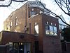
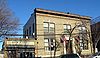
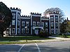
| 26 | Firemen's Hall Firemen's Hall (College Point, New York) Firemen's Hall, also known as College Point Little League Building, is a historic meeting hall located in the College Point section of the New York City borough of Queens. It was built in 1906-1907 and is a two story, rectangular brick building with a hipped roof in the Queen Anne style. A small... |
13-28 123rd St. 40°47′9"N 73°50′44"W |
College Point College Point, Queens College Point is a working-middle class neighborhood in the New York City borough of Queens. It is located north of Flushing on Flushing Bay and the East River and is part of the Queens Community Board 7. Willets Point Boulevard and the Whitestone Expressway are often the neighborhood's... |
|||
| 27 | First Reformed Church First Reformed Church (Queens, New York) The First Reformed Church is a historic Reformed church in the Jamaica section of the New York City borough of Queens. The church was built in 1859. The church has an early romanesque structure that was created built by Sidney J... |
 |
153-10 Jamaica Ave. 40°42′9"N 73°48′8"W |
Jamaica Jamaica, Queens Jamaica is a neighborhood in the borough of Queens in New York City, New York, United States. It was settled under Dutch rule in 1656 in New Netherland as Rustdorp. Under British rule, the Village of Jamaica became the center of the "Town of Jamaica"... |
||
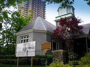
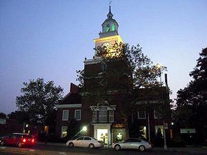
| 28 | Flushing Armory Flushing Armory The Flushing Armory is a historic National Guard armory building located in the Flushing section of the New York City borough of Queens. It is a brick and stone castle-like structure built in 1905–1906, designed to be reminiscent of medieval military structures in Europe. It was designed by State... |
 |
137-58 Northern Boulevard 40°45′47"N 73°49′46"W |
Flushing Flushing, Queens Flushing, founded in 1645, is a neighborhood in the north central part of the City of New York borough of Queens, east of Manhattan.Flushing was one of the first Dutch settlements on Long Island. Today, it is one of the largest and most diverse neighborhoods in New York City... |
||
| 29 | Flushing High School Flushing High School Flushing High School is a four-year public high school in Flushing, in the New York City borough of Queens. The school is operated by the New York City Department of Education.... |
 |
35-01 Union St. 40°45′54"N 73°49′39"W |
Flushing Flushing, Queens Flushing, founded in 1645, is a neighborhood in the north central part of the City of New York borough of Queens, east of Manhattan.Flushing was one of the first Dutch settlements on Long Island. Today, it is one of the largest and most diverse neighborhoods in New York City... |
||
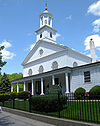
| 30 | Flushing Town Hall Flushing Town Hall Flushing Town Hall is a historic Town Hall located in the Flushing section of the New York City borough of Queens. It was built in 1862 and is a 2-story, three-by-six-bay, brick building with basement and attic. A small rear wing was added in 1938 containing a block of jail cells. The front... |
 |
137-35 Northern Blvd. 40°45′50"N 73°49′49"W |
Flushing Flushing, Queens Flushing, founded in 1645, is a neighborhood in the north central part of the City of New York borough of Queens, east of Manhattan.Flushing was one of the first Dutch settlements on Long Island. Today, it is one of the largest and most diverse neighborhoods in New York City... |
1862, now Flushing Council on the Arts | |
| 31 | Forest Park Carousel Forest Park Carousel Forest Park Carousel is a historic carousel located in the Woodhaven section of the New York City borough of Queens. It was built in 1903 and moved to its present site in 1972 from Dracut, Massachusetts, after the previous carousel was destroyed by fire in 1966. The carousel contains 52 figures,... |
Woodhaven Blvd. and Myrtle Ave. 40°42′3"N 73°51′31"W |
Woodhaven Woodhaven, Queens Woodhaven is a middle-class neighborhood located in the borough of Queens in New York City, New York, United States.Woodhaven is bordered on the north by a public park, Forest Park, and Park Lane South. Woodhaven also borders Richmond Hill to the east, and Ozone Park to the south at Atlantic Avenue... |
|||
| 32 | Forest-Norman Historic District Forest-Norman Historic District Forest-Norman Historic District is a national historic district in Middle Village, Queens, New York. It includes 37 contributing buildings built between 1908 and 1910. They consist of two story brick houses with one apartment per floor and two story brick tenements with two apartments per... |
Forest Ave. from Summerfield to Stephen St. and Norman St. to Myrtle Ave. 40°41′59"N 73°53′58"W |
Middle Village Middle Village, Queens Middle Village is a neighborhood in central Queens, a borough of New York City. The neighborhood is located in the western central section of Queens, bounded to the north by Eliot Avenue, to the east by Woodhaven Boulevard, to the south by Cooper Avenue, and to the west by Fresh Pond Road... |
|||
| 33 | Fort Tilden Historic District | 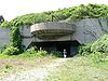 |
Rockaway Beach Boulevard Rockaway Beach Boulevard Rockaway Beach Boulevard, opened in 1886, was the first major east-west thoroughfare on the Rockaway Peninsula in the Borough of Queens in New York City. Much of its route parallels the Rockaway Freeway and the IND Rockaway Line above the Freeway... 40°33′50"N 73°53′28"W |
Rockaway Rockaway, Queens The Rockaway Peninsula, informally The Rockaways, is the name of a peninsula of Long Island, all of which is located within the New York City borough of Queens. A popular summer resort area since the 1830s, Rockaway has become a mixture of lower, middle, and upper-class neighborhoods... |
||
| 34 | Fort Totten Officers' Club Fort Totten Officers' Club Fort Totten Officers' Club is a historic clubhouse located at Fort Totten in Bayside, Queens, New York. It was built in the 1870s and expanded to its present size in 1887. It is a large Late Gothic Revival style building. It is a two story, rectangular frame building with a projecting central... |
 |
Totten and Murray Aves. 40°47′32"N 73°46′41"W |
Bayside Bayside, Queens Bayside is a suburban neighborhood in the borough of Queens in New York, New York in the United States. Bayside is known as one of the most expensive areas to live in Queens, with well kept homes and landscaping... |
||
| 35 | Free Synagogue of Flushing Free Synagogue of Flushing The Free Synagogue of Flushing is a Reform synagogue in the Flushing neighborhood of Queens, New York City.The congregation was established in 1917 as part of Rabbi Stephen Samuel Wise's "Free Synagogue" movement. Architect Maurice Courland designed the Neoclassical building... |
41-60 Kissena Blvd. 40°45′26.85"N 73°49′39.71"W |
Flushing Flushing, Queens Flushing, founded in 1645, is a neighborhood in the north central part of the City of New York borough of Queens, east of Manhattan.Flushing was one of the first Dutch settlements on Long Island. Today, it is one of the largest and most diverse neighborhoods in New York City... |
|||
| 36 | Fresh Pond-Traffic Historic District Fresh Pond-Traffic Historic District Fresh Pond-Traffic Historic District is a national historic district in Ridgewood, Queens, New York. It includes 197 contributing buildings built between 1914 and 1921. They consist mainly of brick two story row houses with one apartment per floor... |
Roughly bounded by Fresh Pond Rd., Traffic Ave., Woodbine and Linden Sts. 40°42′34"N 73°53′49"W |
Ridgewood Ridgewood, Queens Ridgewood is a neighborhood in the New York City borough of Queens. It borders the neighborhoods of Maspeth, Middle Village and Glendale, as well as the Brooklyn neighborhood of Bushwick. Historically, the neighborhood straddled the Queens-Brooklyn boundary. The neighborhood is part of Queens... |
|||
| 37 | Grace Episcopal Church Complex Grace Episcopal Church Complex (Queens, New York) Grace Episcopal Church Complex is a historic Episcopal church complex at 155-15 Jamaica Avenue in Jamaica, Queens, New York, New York. The complex includes the church, parish house, and cemetery. The church was built between 1861 and 1862. It is constructed of rough-cut sandstone and features a... |
 |
15515 Jamaica Avenue Jamaica Avenue Jamaica Avenue is a major avenue in the boroughs of Brooklyn and Queens in New York City, New York, in the United States. Jamaica Avenue starts at Broadway and Fulton Street in the East New York neighborhood in Brooklyn, and goes to the city line in Bellerose, Queens, where it becomes Jericho... 40°42′14"N 73°48′7"W |
Jamaica Jamaica, Queens Jamaica is a neighborhood in the borough of Queens in New York City, New York, United States. It was settled under Dutch rule in 1656 in New Netherland as Rustdorp. Under British rule, the Village of Jamaica became the center of the "Town of Jamaica"... |
||
| 38 | Grove-Linden-St. John's Historic District Grove-Linden-St. John's Historic District Grove-Linden-St. John's Historic District is a national historic district in Middle Village, Queens, New York. It includes 51 contributing buildings built between 1908 and 1910. They consist of three story brick tenements with two apartments per floor. There are also a number of two- and... |
Fairview Ave., St. John's Rd., Linden and Grove Sts. 40°42′23"N 73°54′26"W |
Middle Village Middle Village, Queens Middle Village is a neighborhood in central Queens, a borough of New York City. The neighborhood is located in the western central section of Queens, bounded to the north by Eliot Avenue, to the east by Woodhaven Boulevard, to the south by Cooper Avenue, and to the west by Fresh Pond Road... |
|||
| 39 | Hunters Point Historic District | Along 45th Ave., between 21st and 23rd Sts. 40°44′49"N 73°56′48"W |
Long Island City | |||
| 40 | Jackson Heights Historic District | Bounded by Roosevelt Ave., Broadway, Leverich St., Northern Blvd., and 90th St. 40°45′5"N 73°53′13"W |
Jackson Heights Jackson Heights, Queens Jackson Heights is a neighborhood in the Northwestern portion of the borough of Queens in New York, New York, United States. The neighborhood is part of Queens Community Board 3... |
|||
| 41 | Jacob Riis Park Historic District Jacob Riis Park Historic District Jacob Riis Park Historic District is a historic district that was listed on the National Register of Historic Places in 1981.Jacob Riis Park is administered by the National Park Service and is part of Gateway National Recreation Area.... |
Rockaway Beach Blvd. 40°34′3"N 73°52′24"W |
Rockaway Rockaway, Queens The Rockaway Peninsula, informally The Rockaways, is the name of a peninsula of Long Island, all of which is located within the New York City borough of Queens. A popular summer resort area since the 1830s, Rockaway has become a mixture of lower, middle, and upper-class neighborhoods... |
Presumably including but larger than Jacob Riis Park Jacob Riis Park Jacob Riis Park in the New York City borough of Queens, is part of the Jamaica Bay Unit of the Gateway National Recreation Area, and is managed by the National Park Service . It lies at the foot of the Marine Parkway-Gil Hodges Memorial Bridge, toward the southwestern end the Rockaway Peninsula,... |
||
| 42 | Jamaica Chamber of Commerce Building Jamaica Chamber of Commerce Building Jamaica Chamber of Commerce Building is a historic office building located in the Jamaica section of the New York City borough of Queens. It was designed in 1928 by George W. Conable and is a ten story, "T" shaped building in the Colonial Revival style. It is a steel frame building faced in red... |
8931 161st St. 40°42′19"N 73°48′0"W |
Jamaica Jamaica, Queens Jamaica is a neighborhood in the borough of Queens in New York City, New York, United States. It was settled under Dutch rule in 1656 in New Netherland as Rustdorp. Under British rule, the Village of Jamaica became the center of the "Town of Jamaica"... |
|||
| 43 | Jamaica Savings Bank Jamaica Savings Bank The Jamaica Savings Bank building, located in the Jamaica section of the borough of Queens in New York City, was built between 1897 and 1898 in the Beaux-Arts style. It is a slender four story brick building with a limestone facade. It features a deeply rusticated ground floor with windows... |
161-02 Jamaica Ave. 40°42′14"N 73°47′57"W |
Jamaica Jamaica, Queens Jamaica is a neighborhood in the borough of Queens in New York City, New York, United States. It was settled under Dutch rule in 1656 in New Netherland as Rustdorp. Under British rule, the Village of Jamaica became the center of the "Town of Jamaica"... |
|||
| 44 | King Manor King Manor King Manor, also known as the Rufus King House, is in Jamaica, Queens. It was the home of Rufus King, a signer of the United States Constitution, a Senator from New York, and Ambassador to Great Britain immediately after the American Revolution... |
 |
150th St. and Jamaica Ave. 40°42′11"N 73°51′43"W |
Jamaica Jamaica, Queens Jamaica is a neighborhood in the borough of Queens in New York City, New York, United States. It was settled under Dutch rule in 1656 in New Netherland as Rustdorp. Under British rule, the Village of Jamaica became the center of the "Town of Jamaica"... |
||
| 45 | Kingsland Homestead Kingsland Homestead Kingsland Homestead, located in Flushing, Queens is a New York City landmark and member of the Historic House Trust. It is the home of the remains of a landmarked, weeping beech tree, believed planted in 1847 and located... |
37th St. and Parsons Blvd. 40°45′49"N 73°49′27"W |
Flushing Flushing, Queens Flushing, founded in 1645, is a neighborhood in the north central part of the City of New York borough of Queens, east of Manhattan.Flushing was one of the first Dutch settlements on Long Island. Today, it is one of the largest and most diverse neighborhoods in New York City... |
|||
| 46 | J. Kurtz and Sons Store Building J. Kurtz and Sons Store Building J. Kurtz and Sons Store Building is a historic commercial building located in the Jamaica section of the New York City borough of Queens. It was built in 1931 and is a six-story, steel-frame building with two decorated sides in the Art Deco style. It is three bays by six bays and features a... |
162-24 Jamaica Ave. 40°42′16"N 73°47′52"W |
Jamaica Jamaica, Queens Jamaica is a neighborhood in the borough of Queens in New York City, New York, United States. It was settled under Dutch rule in 1656 in New Netherland as Rustdorp. Under British rule, the Village of Jamaica became the center of the "Town of Jamaica"... |
|||
| 47 | La Casina La Casina La Casina is a historic commercial building located in the Jamaica section of the New York City borough of Queens. It was originally built about 1907 and completely redesigned about 1936 in the Streamline Moderne style. It is one story building designed for use as a nightclub. It has a... |
90-33 160th St. 40°42′16"N 73°48′0"W |
Jamaica Jamaica, Queens Jamaica is a neighborhood in the borough of Queens in New York City, New York, United States. It was settled under Dutch rule in 1656 in New Netherland as Rustdorp. Under British rule, the Village of Jamaica became the center of the "Town of Jamaica"... |
|||
| 48 | Lent Homestead and Cemetery Lent Homestead and Cemetery Lent Homestead and Cemetery is a historic cemetery at 78-03 19th Road in East Elmhurst, New York.It was founded in 1729 and added to the National Register of Historic Places in 1984.... |
78-03 19th Rd. 40°46′23"N 73°53′31"W |
Jackson Heights Jackson Heights, Queens Jackson Heights is a neighborhood in the Northwestern portion of the borough of Queens in New York, New York, United States. The neighborhood is part of Queens Community Board 3... |
|||
| 49 | Long Island City Courthouse Complex Long Island City Courthouse Complex The Long Island City Courthouse is located at 25-10 Court Square in Long Island City, Queens, in New York City. It formerly housed Criminal Court, County Court, the District Attorney staff, and the county sheriff's office. Today the Courthouse is another home to the Civil Term of Supreme Court,... |
 |
25-10 Court Sq. 40°44′45"N 73°56′36"W |
Long Island City Long Island City, Queens Long Island City is the westernmost neighborhood of the borough of Queens in New York City. L.I.C. is notable for its rapid and ongoing gentrification, its waterfront parks, and its thriving arts community. L.I.C. has among the highest concentration of art galleries, art institutions, and studio... |
||
| 50 | Long Island Motor Parkway Long Island Motor Parkway The Long Island Motor Parkway , also known as the Vanderbilt Parkway and Motor Parkway, was the first roadway designed for automobile use only. It was privately built by William Kissam Vanderbilt with overpasses and bridges to remove intersections... |
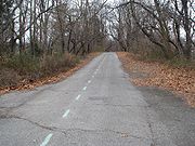 |
Roughly Alley Pond and Cunningham Parks, bet. Winchester Blvd. and Clearview Expressway, bet. 73rd Ave. and Peck Ave. 40°44′13"N 73°45′35"W |
Queens Queens Queens is the easternmost of the five boroughs of New York City. The largest borough in area and the second-largest in population, it is coextensive with Queens County, an administrative division of New York state, in the United States.... |
||
| 51 | Madison-Putnam-60th Place Historic District Madison-Putnam-60th Place Historic District Madison-Putnam-60th Place Historic District is a national historic district in Ridgewood, Queens, New York. It includes 145 contributing buildings built between 1900 and 1920. They consist mainly of brick two story row houses with one apartment per floor and three story tenements with two... |
Roughly bounded by Woodbine St., 60th Pl., 67th and Forest Aves. 40°42′21"N 73°54′6"W |
Ridgewood Ridgewood, Queens Ridgewood is a neighborhood in the New York City borough of Queens. It borders the neighborhoods of Maspeth, Middle Village and Glendale, as well as the Brooklyn neighborhood of Bushwick. Historically, the neighborhood straddled the Queens-Brooklyn boundary. The neighborhood is part of Queens... |
|||
| 52 | Main Street Subway station ( trains) | 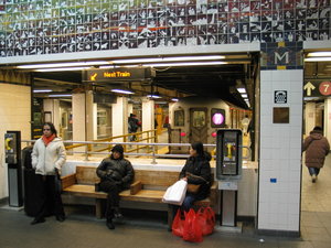 |
Near jct. of Roosevelt Ave. and Main St. 40°45′34"N 73°49′51"W |
Flushing Flushing, Queens Flushing, founded in 1645, is a neighborhood in the north central part of the City of New York borough of Queens, east of Manhattan.Flushing was one of the first Dutch settlements on Long Island. Today, it is one of the largest and most diverse neighborhoods in New York City... |
||
| 53 | Maple Grove Cemetery Maple Grove Cemetery (Kew Gardens, New York) Maple Grove Cemetery is a historic cemetery at 83-15 Kew Gardens Road in Kew Gardens, Queens, New York, New York. It was established in 1875 and consists of two sections; Monumental Park and Memorial Park... |
 |
83-15 Kew Gardens Rd. 40°42′31"N 73°49′27"W |
Kew Gardens Kew Gardens, Queens Kew Gardens is a triangular-shaped neighborhood in central Queens bounded to the north by the Jackie Robinson Parkway , to the east by Van Wyck Expressway and 131st Street, to the south by Hillside Avenue, and to the west by Park Lane, Abingdon Road and 118th Street... |
||
| 54 | Marine Air Terminal Marine Air Terminal -External links:*... |
 |
La Guardia Airport 40°46′25"N 73°53′10"W |
La Guardia Airport | ||
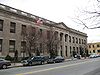
| 55 | Office of the Register Office of the Register Office of the Register, also known as Queens Register of Titles and Deeds Building, is a historic government building located in the Jamaica section of the New York City borough of Queens. It was built between 1895 and 1913 and is an imposing, three story building with a limestone facade in the... |
161-04 Jamaica Ave. 40°42′13"N 73°47′57"W |
Jamaica Jamaica, Queens Jamaica is a neighborhood in the borough of Queens in New York City, New York, United States. It was settled under Dutch rule in 1656 in New Netherland as Rustdorp. Under British rule, the Village of Jamaica became the center of the "Town of Jamaica"... |
|||
| 56 | Old Quaker Meetinghouse |  |
S side of Northern Blvd. 40°45′47"N 73°49′51"W |
Flushing Flushing, Queens Flushing, founded in 1645, is a neighborhood in the north central part of the City of New York borough of Queens, east of Manhattan.Flushing was one of the first Dutch settlements on Long Island. Today, it is one of the largest and most diverse neighborhoods in New York City... |
||
| 57 | Paramount Studios Complex Kaufman Astoria Studios The Kaufman Astoria Studios is an historic movie studio located in the Astoria section of the New York City borough of Queens.-History:It was originally built by Famous Players-Lasky in 1920 to provide the company with a facility close to the Broadway theater district. Many features and short... |
 |
35th Ave., 35th, 36th, and 37th Sts. 40°45′24"N 73°55′30"W |
Astoria Astoria, Queens Astoria is a neighborhood in the northwestern corner of the borough of Queens in New York City. Located in Community Board 1, Astoria is bounded by the East River and is adjacent to three other Queens neighborhoods: Long Island City, Sunnyside , and Woodside... |
Now Kaufman Astoria Studios | |
| 58 | Poppenhusen Institute Poppenhusen Institute Poppenhusen Institute is a historic building at 114—04 14th Road in College Point, Queens that housed the first free kindergarten in America. Currently, the Institute operates as a community cultural center.... |
 |
114-04 14th Rd. 40°47′4"N 73°51′13"W |
College Point College Point, Queens College Point is a working-middle class neighborhood in the New York City borough of Queens. It is located north of Flushing on Flushing Bay and the East River and is part of the Queens Community Board 7. Willets Point Boulevard and the Whitestone Expressway are often the neighborhood's... |
||
| 59 | Prospect Cemetery Prospect Cemetery (Jamaica, New York) Prospect Cemetery is a historic cemetery located in the Jamaica section of the New York City borough of Queens. It was established in 1668 and known as the "burring plas." The cemetery was generally known as the Presbyterian burial ground and is one of the few remaining Colonial cemeteries in... |
159th St. and Beaver Rd. 40°42′4"N 73°48′1"W |
Jamaica Jamaica, Queens Jamaica is a neighborhood in the borough of Queens in New York City, New York, United States. It was settled under Dutch rule in 1656 in New Netherland as Rustdorp. Under British rule, the Village of Jamaica became the center of the "Town of Jamaica"... |
|||
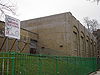
| 60 | Public School 66 Public School 66 Public School 66, once known as Brooklyn Hills School, is a historic Public School 66, once known as Brooklyn Hills School, is a historic... |
85-11 102nd St. 40°41′52"N 73°50′47"W |
Richmond Hill | |||
| 61 | Queens County Savings Bank Queens County Savings Bank Queens County Savings Bank is a historic bank building located in the Kew Gardens Hills section of the New York City borough of Queens. It was built in 1953-1954 to resemble Independence Hall in the Georgian Revival style. It is a brick building that consists of a tall central tower with flanking... |
 |
75-44 Main St. 40°43′21"N 73°49′14"W |
Kew Gardens Hills Kew Gardens Hills, Queens Kew Gardens Hills, also sometimes incorrectly referred to as Kew Garden Hills, is a one-square mile sub-neighborhood of Flushing in the New York City borough of Queens. The western border is Flushing Meadows-Corona Park, on the north is Jewel Avenue, on the south is Union Turnpike and to the east... |
||
| 62 | Queensboro Bridge Queensboro Bridge The Ed Koch Queensboro Bridge, also known as the 59th Street Bridge – because its Manhattan end is located between 59th and 60th Streets – or simply the Queensboro Bridge, is a cantilever bridge over the East River in New York City that was completed in 1909... |
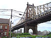 |
59th St. 40°45′26"N 73°57′22"W |
Long Island City Long Island City, Queens Long Island City is the westernmost neighborhood of the borough of Queens in New York City. L.I.C. is notable for its rapid and ongoing gentrification, its waterfront parks, and its thriving arts community. L.I.C. has among the highest concentration of art galleries, art institutions, and studio... |
||
| 63 | Reformed Church of Newtown Complex The Reformed Church of Newtown The Reformed Church of Newtown is a historic Reformed church located in the Elmhurst neighborhood in Queens, New York.-Current Building:The original church building was replaced in 1832 by the present sanctuary, which is a designated landmark building. The cornerstone of the original building can... |
 |
85-15 Broadway 40°44′23"N 73°52′42"W |
Elmhurst Elmhurst, Queens Elmhurst is a neighborhood in the New York City borough of Queens. It is bounded by Roosevelt Avenue on the north; Corona to the northeast; Junction Boulevard on the east; Rego Park to the southeast; the Long Island Expressway on the south; Middle Village to the south and southwest; and Maspeth... |
||
| 64 | Rego Park Jewish Center Rego Park Jewish Center The Rego Park Jewish Center is a synagogue in the Rego Park neighborhood of Queens, New York City.The architectural firm of Frank Grad & Sons designed the modernist building. The facade features a mosaic by Hungarian-born artist A. Raymond Katz.... |
97-30 Queens Blvd. 40°43′41.49"N 73°51′33.7"W |
Rego Park Rego Park, Queens Rego Park is a neighborhood in the New York City borough of Queens.-Geography:Rego Park is bordered to the north by Elmhurst and Corona, the east and south by Forest Hills and the west by Middle Village.-History:... |
|||
| 65 | RKO Keith's Theater (Flushing, New York) RKO Keith's Theater (Flushing, New York) RKO Keith's Theater is a historic RKO Pictures movie theater located in the Flushing section of the New York City borough of Queens. It was designed by noted theater architect Thomas W. Lamb and built in 1928. It has a plain three story exterior facade, but the auditorium interior was once... |
 |
129-143 Northern Blvd. 40°45′48"N 73°49′57"W |
Flushing Flushing, Queens Flushing, founded in 1645, is a neighborhood in the north central part of the City of New York borough of Queens, east of Manhattan.Flushing was one of the first Dutch settlements on Long Island. Today, it is one of the largest and most diverse neighborhoods in New York City... |
||
| 66 | Russell Sage Memorial Church | 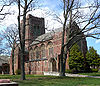 |
1324 Beach 12 St. 40°36′34"N 73°44′51"W |
Far Rockaway Far Rockaway, Queens Far Rockaway is a neighborhood on the Rockaway Peninsula in the New York City borough of Queens in the United States. It is the easternmost section of the Rockaways. The neighborhood starts at the Nassau County line and extends west to Beach 32nd Street. The neighborhood is part of Queens Community... |
Church designed by Ralph Adams Cram Ralph Adams Cram Ralph Adams Cram FAIA, , was a prolific and influential American architect of collegiate and ecclesiastical buildings, often in the Gothic style. Cram & Ferguson and Cram, Goodhue & Ferguson are partnerships in which he worked.-Early life:Cram was born on December 16, 1863 at Hampton Falls, New... with Louis Tiffany windows, recently restored. |
|
| 67 | Saint Benedict Joseph Labre Parish Saint Benedict Joseph Labre Parish Saint Benedict Joseph Labre Parish is a historic Roman Catholic parish church complex at 94-40 118th Street in Richmond Hill neighborhood of Queens, New York. The complex consists of the church, rectory / parsonage, school, and cloister. The church was designed in 1916 by noted architect Thomas... |
94-40 118th St. 40°41′33"N 73°49′47"W |
Richmond Hill | |||
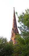
| 68 | St. George's Church St. George's Church (Flushing, New York) St. George's Church is an intercultural, multilingual Episcopal congregation in Flushing, New York with members from over twenty different nations of origin. A landmark church, it has served an ever changing congregation for over 300 years.-History:... |
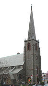 |
135-32 38th Ave. 40°45′37.38"N 73°49′55.02"W |
Flushing Flushing, Queens Flushing, founded in 1645, is a neighborhood in the north central part of the City of New York borough of Queens, east of Manhattan.Flushing was one of the first Dutch settlements on Long Island. Today, it is one of the largest and most diverse neighborhoods in New York City... |
(new listing; refnum 08000143) | |
| 69 | St. James Church, Elmhurst St. James Church, Elmhurst St. James Church, also known as Church of England in America; Mission Church at Newton; St. James Protestant Episcopal Church; Parish Hall; Community Hall, is a historic Episcopal church at 86-02 Broadway in Elmhurst, Queens, New York.It was built in 1735 and is the oldest surviving Anglican... |
86-02 Broadway 40°44′18"N 73°52′41"W |
Elmhurst | |||
| 70 | St. Luke's Episcopal Church | 85 Greenway South 40°42′50"N 73°50′41"W |
Forest Hills Forest Hills, Queens Forest Hills is a neighborhood in the borough of Queens in New York City, New York, United States.-Neighborhood:The neighborhood is home to upper-middle class residents, of whom the wealthier residents often live in the neighborhood's Forest Hills Gardens area... |
New listing; refnum 10000900 | ||
| 71 | St. Matthew's Episcopal Church St. Matthew's Episcopal Church (Woodhaven, New York) St. Matthew's Episcopal Church, also known as St. Matthew's Episcopal Church and Close, is a historic Episcopal church at 85-45 96th Street in Woodhaven, Queens, New York. Located behind the church is the Wyckoff-Snediker Family Cemetery.... |
85-45 96th St. 40°41′46"N 73°50′58"W |
Woodhaven Woodhaven, Queens Woodhaven is a middle-class neighborhood located in the borough of Queens in New York City, New York, United States.Woodhaven is bordered on the north by a public park, Forest Park, and Park Lane South. Woodhaven also borders Richmond Hill to the east, and Ozone Park to the south at Atlantic Avenue... |
|||
| 72 | St. Monica's Church St. Monica's Church (Queens, New York) St. Monica's Church is a historic Roman Catholic church in Jamaica, Queens, New York. It was built in 1856 and is a brick basilica type building in the Romanesque style. It features a four story entrance tower in the center of its three bay wide front facade... |
94-20 160th St. 40°42′7"N 73°47′53"W |
Jamaica Jamaica, Queens Jamaica is a neighborhood in the borough of Queens in New York City, New York, United States. It was settled under Dutch rule in 1656 in New Netherland as Rustdorp. Under British rule, the Village of Jamaica became the center of the "Town of Jamaica"... |
|||
| 73 | Seneca Avenue East Historic District Seneca Avenue East Historic District Seneca Avenue East Historic District is a national historic district in Ridgewood, Queens, New York. It includes 120 contributing buildings built between 1900 and 1915. They consist mainly of brick two story row houses with one apartment per floor and three story tenements with two apartments per... |
Roughly Seneca Ave. E. between Hancock and Summerfield Sts. 40°41′59"N 73°54′7"W |
Ridgewood Ridgewood, Queens Ridgewood is a neighborhood in the New York City borough of Queens. It borders the neighborhoods of Maspeth, Middle Village and Glendale, as well as the Brooklyn neighborhood of Bushwick. Historically, the neighborhood straddled the Queens-Brooklyn boundary. The neighborhood is part of Queens... |
|||
| 74 | Seneca-Onderdonk-Woodward Historic District Seneca-Onderdonk-Woodward Historic District Seneca-Onderdonk-Woodward Historic District is a national historic district in Middle Village, Queens, New York. It includes 211 contributing buildings built in 1911-1912. They consist mainly of three story brick tenements with two apartments per floor... |
Roughly bounded by Woodward, Seneca, Catalpa Aves., and Woodbine St. 40°42′9"N 73°54′17"W |
Middle Village Middle Village, Queens Middle Village is a neighborhood in central Queens, a borough of New York City. The neighborhood is located in the western central section of Queens, bounded to the north by Eliot Avenue, to the east by Woodhaven Boulevard, to the south by Cooper Avenue, and to the west by Fresh Pond Road... |
|||
| 75 | Sidewalk Clock at 161-11 Jamaica Avenue, New York, NY | 161-11 Jamaica Ave. 40°42′15"N 73°47′56"W |
Jamaica Jamaica, Queens Jamaica is a neighborhood in the borough of Queens in New York City, New York, United States. It was settled under Dutch rule in 1656 in New Netherland as Rustdorp. Under British rule, the Village of Jamaica became the center of the "Town of Jamaica"... |
|||
| 76 | Steinway Mansion Steinway Mansion Steinway Mansion or Steinway House is a historic home on a hilltop in Astoria, Queens, New York City. It was built in 1858 and occupied by William Steinway in the early 1870s. It was listed on the National Register of Historic Places in 1983.... |
18-22 41st St. 40°46′42"N 73°53′52"W |
Astoria Astoria, Queens Astoria is a neighborhood in the northwestern corner of the borough of Queens in New York City. Located in Community Board 1, Astoria is bounded by the East River and is adjacent to three other Queens neighborhoods: Long Island City, Sunnyside , and Woodside... |
|||
| 77 | Stockholm-DeKalb-Hart Historic District Stockholm-DeKalb-Hart Historic District Stockholm-DeKalb-Hart Historic District is a national historic district in Ridgewood, Queens, New York. It includes 79 contributing buildings built between 1900 and 1915. They consist mainly of brick two story row houses with one apartment per floor... |
Roughly DeKalb and Woodward Aves., Stockholm and Hart Sts. 40°42′32"N 73°54′52"W |
Ridgewood Ridgewood, Queens Ridgewood is a neighborhood in the New York City borough of Queens. It borders the neighborhoods of Maspeth, Middle Village and Glendale, as well as the Brooklyn neighborhood of Bushwick. Historically, the neighborhood straddled the Queens-Brooklyn boundary. The neighborhood is part of Queens... |
|||
| 78 | Summerfield Street Row Historic District Summerfield Street Row Historic District Summerfield Street Row Historic District is a national historic district in Ridgewood, Queens, New York. It includes 19 contributing buildings built in 1912. They are brick two story row houses with one apartment per floor. They feature round bays and yellow iron-spot brick facades.It was listed... |
5912-5948 Summerfield St. 40°42′0.9252"N 73°53′48.3174"W |
Ridgewood Ridgewood, Queens Ridgewood is a neighborhood in the New York City borough of Queens. It borders the neighborhoods of Maspeth, Middle Village and Glendale, as well as the Brooklyn neighborhood of Bushwick. Historically, the neighborhood straddled the Queens-Brooklyn boundary. The neighborhood is part of Queens... |
|||
| 79 | Sunnyside Gardens Historic District | Roughly bounded by Queens Blvd., 43rd and 52nd Sts. Barnett and Skillman Aves. 40°44′49"N 73°55′3"W |
Sunnyside Gardens Sunnyside Gardens, Queens Sunnyside Gardens, in the Sunnyside neighborhood of the New York City borough of Queens, was one of the first developments to incorporate the "superblock" model in the United States... |
|||
| 80 | Trans World Airlines Flight Center | 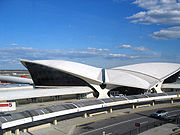 |
John F. Kennedy International Airport 40°38′44.86"N 73°46′39.27"W |
Jamaica Jamaica, Queens Jamaica is a neighborhood in the borough of Queens in New York City, New York, United States. It was settled under Dutch rule in 1656 in New Netherland as Rustdorp. Under British rule, the Village of Jamaica became the center of the "Town of Jamaica"... |
Designed by Eero Saarinen Eero Saarinen Eero Saarinen was a Finnish American architect and industrial designer of the 20th century famous for varying his style according to the demands of the project: simple, sweeping, arching structural curves or machine-like rationalism.-Biography:Eero Saarinen shared the same birthday as his father,... |
|
| 81 | Trinity Chapel Trinity Chapel (Far Rockaway, New York) Trinity Chapel, also known as St. John's Church and Beth-El Temple Church of God in Christ, is a historic Episcopal church at 1874 Mott Avenue in Far Rockaway, Queens, New York. It was built in 1858 to the design of noted architect Richard Upjohn . It is a frame Gothic Revival style chapel on a... |
1874 Mott Avenue 40°36′13"N 73°45′5"W |
Far Rockaway Far Rockaway, Queens Far Rockaway is a neighborhood on the Rockaway Peninsula in the New York City borough of Queens in the United States. It is the easternmost section of the Rockaways. The neighborhood starts at the Nassau County line and extends west to Beach 32nd Street. The neighborhood is part of Queens Community... |
|||
| 82 | Trinity Lutheran Church Trinity Lutheran Church (Queens, New York) Trinity Lutheran Church is a historic Lutheran church at 31-18 37th Street in Astoria, Queens, New York. It was designed by John William Cresswell Corbusier and overseen by noted architect George W. Conable . It was built in 1926 and is a one story Collegiate Gothic style building. It is... |
31-18 37th St. 40°45′42.31"N 73°55′9.2"W |
Astoria Astoria, Queens Astoria is a neighborhood in the northwestern corner of the borough of Queens in New York City. Located in Community Board 1, Astoria is bounded by the East River and is adjacent to three other Queens neighborhoods: Long Island City, Sunnyside , and Woodside... |
(new listing, refnum 08000471) | ||
| 83 | US Post Office-Far Rockaway United States Post Office (Far Rockaway, Queens) US Post Office-Far Rockaway is a historic post office building located at Far Rockaway in Queens County, New York, United States. It was built in 1935, and is one of six post offices in New York State designed by architect Eric Kebbon as a consultant to the Office of the Supervising Architect... |
18-36 Mott Avenue 40°36′12"N 73°45′3"W |
Far Rockaway Far Rockaway, Queens Far Rockaway is a neighborhood on the Rockaway Peninsula in the New York City borough of Queens in the United States. It is the easternmost section of the Rockaways. The neighborhood starts at the Nassau County line and extends west to Beach 32nd Street. The neighborhood is part of Queens Community... |
|||
| 84 | US Post Office-Flushing Main United States Post Office (Flushing, Queens) US Post Office-Flushing Main is a historic post office building located at Flushing in Queens County, New York, United States. It was designed and built between 1932 and 1934 by architect Dwight James Baum and William W. Knowles as consulting architects to the Office of the Supervising Architect... |
 |
41-65 Main St. 40°45′33"N 73°49′43"W |
Flushing Flushing, Queens Flushing, founded in 1645, is a neighborhood in the north central part of the City of New York borough of Queens, east of Manhattan.Flushing was one of the first Dutch settlements on Long Island. Today, it is one of the largest and most diverse neighborhoods in New York City... |
||
| 85 | US Post Office-Forest Hills Station United States Post Office (Forest Hills, Queens) US Post Office-Forest Hills Station is a historic post office building located at Forest Hills in Queens County, New York, United States. It was built in 1937, and was designed by architect Lorimer Rich as a consultant to the Office of the Supervising Architect. It is a one story flat roofed... |
106-28 Queens Blvd. 40°43′18"N 73°50′50"W |
Forest Hills Forest Hills, Queens Forest Hills is a neighborhood in the borough of Queens in New York City, New York, United States.-Neighborhood:The neighborhood is home to upper-middle class residents, of whom the wealthier residents often live in the neighborhood's Forest Hills Gardens area... |
|||
| 86 | US Post Office-Jackson Heights Station United States Post Office (Jackson Heights, Queens) US Post Office-Jackson Heights Station is a historic post office building located at Jackson Heights in Queens County, New York, United States. The original section was built in 1936-1937, and was designed by architect Benjamin C. Flournoy as a consultant to the Office of the Supervising Architect... |
78-02 37th Ave. 40°44′57"N 73°53′16"W |
Jackson Heights Jackson Heights, Queens Jackson Heights is a neighborhood in the Northwestern portion of the borough of Queens in New York, New York, United States. The neighborhood is part of Queens Community Board 3... |
|||
| 87 | US Post Office-Jamaica Main United States Post Office (Jamaica, Queens) US Post Office-Jamaica Main is a historic post office building located at Jamaica in Queens County, New York, United States. It was built in 1932-1934, and is one of two post offices in New York City designed by architects Cross and Cross as a consultant to the Office of the Supervising Architect... |
88-40 164th St. 40°45′40"N 73°48′8"W |
Jamaica Jamaica, Queens Jamaica is a neighborhood in the borough of Queens in New York City, New York, United States. It was settled under Dutch rule in 1656 in New Netherland as Rustdorp. Under British rule, the Village of Jamaica became the center of the "Town of Jamaica"... |
|||
| 88 | US Post Office-Long Island City United States Post Office (Long Island City, Queens) US Post Office-Long Island City is a historic post office building located at Long Island City in Queens County, New York, United States. It was built in 1928, and is one of a number of post offices in New York designed by the Office of the Supervising Architect under director James A. Wetmore... |
 |
46-02 21st St. 40°44′44"N 73°56′57"W |
Long Island City Long Island City, Queens Long Island City is the westernmost neighborhood of the borough of Queens in New York City. L.I.C. is notable for its rapid and ongoing gentrification, its waterfront parks, and its thriving arts community. L.I.C. has among the highest concentration of art galleries, art institutions, and studio... |
||
| 89 | Cornelius Van Wyck House Cornelius Van Wyck House The Cornelius Van Wyck House is an 18th century Dutch Colonial home located on the shore of Little Neck Bay in the Douglaston section of Queens in New York City... |
37-04 Douglaston Parkway 40°46′23"N 73°45′12"W |
Douglaston Douglaston, Queens Douglaston, population 14,168 , is a community in the New York City borough of Queens. Douglaston comprises six distinct neighborhoods: Doug Bay, Douglas Manor, and Douglaston Hill, all located north of Northern Boulevard on the peninsula abutting Little Neck Bay; Douglaston Park, located between... |
|||
| 90 | Vander Ende-Onderdonk House Site Vander Ende-Onderdonk House Site Vander Ende--Onderdonk House is a historic house at 1820 Flushing Avenue in Ridgewood, Queens. It is the oldest Dutch Colonial stone house in New York City.... |
1820 Flushing Ave. 40°42′40"N 73°55′12"W |
Ridgewood Ridgewood, Queens Ridgewood is a neighborhood in the New York City borough of Queens. It borders the neighborhoods of Maspeth, Middle Village and Glendale, as well as the Brooklyn neighborhood of Bushwick. Historically, the neighborhood straddled the Queens-Brooklyn boundary. The neighborhood is part of Queens... |
|||
| 91 | Woodbine-Palmetto-Gates Historic District Woodbine-Palmetto-Gates Historic District Woodbine-Palmetto-Gates Historic District is a national historic district in Middle Village, Queens, New York. It includes 91 contributing buildings built between 1908 and 1911. They consist mainly of three story brick tenements with two apartments per floor... |
Roughly bounded by Forest and Fairview Aves., Woodbine and Linden Sts. 40°42′25"N 73°54′15"W |
Middle Village Middle Village, Queens Middle Village is a neighborhood in central Queens, a borough of New York City. The neighborhood is located in the western central section of Queens, bounded to the north by Eliot Avenue, to the east by Woodhaven Boulevard, to the south by Cooper Avenue, and to the west by Fresh Pond Road... |
|||
| 92 | Wyckoff-Snediker Family Cemetery Wyckoff-Snediker Family Cemetery Wyckoff-Snediker Family Cemetery is a historic cemetery located in the Woodhaven section of the New York City borough of Queens. It is located behind St. Matthew's Episcopal Church. It has grave markers that denote burials dating from 1793 to 1892... |
85-45 96th St. 40°41′46"N 73°50′57"W |
Woodhaven Woodhaven, Queens Woodhaven is a middle-class neighborhood located in the borough of Queens in New York City, New York, United States.Woodhaven is bordered on the north by a public park, Forest Park, and Park Lane South. Woodhaven also borders Richmond Hill to the east, and Ozone Park to the south at Atlantic Avenue... |
See also
- Statewide: National Register of Historic Places listings in New York
- Citywide: Manhattan, Brooklyn, Staten Island, Bronx
- List of New York City Designated Landmarks in Queens