

List of Pennsylvania state historical markers in Susquehanna County
Encyclopedia
This is intended to be a complete list of the official state historical markers placed in Susquehanna County, Pennsylvania
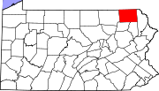
Susquehanna County, Pennsylvania
-Demographics:As of the census of 2000, there were 42,238 people, 16,529 households, and 11,785 families residing in the county. The population density was 51 people per square mile . There were 21,829 housing units at an average density of 26 per square mile...
by the Pennsylvania Historical and Museum Commission
Pennsylvania Historical and Museum Commission
The Pennsylvania Historical and Museum Commission is the governmental agency of the Commonwealth of Pennsylvania responsible for the collection, conservation and interpretation of Pennsylvania's historic heritage...
(PHMC). The locations of the historical markers, as well as the latitude and longitude coordinates as provided by the PHMC's database, are included below when available. There are ten historical markers located in Susquehanna County.
Historical markers
| Marker title | Image | Date dedicated | Location | Marker type | Topics |
|---|---|---|---|---|---|
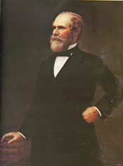
| Galusha Grow Galusha A. Grow Galusha Aaron Grow was a prominent U.S. politician, lawyer, writer and businessman, and was Speaker of the House of Representatives from 1861 to 1863. He was defeated for reelection in 1862... |
 |
Intersection US 11 & PA 547, N of Kingsley 41.76232°N 75.75308°W |
Roadside | Early Settlement, Government & Politics, Government & Politics 19th Century | |
| Galusha Grow Galusha A. Grow Galusha Aaron Grow was a prominent U.S. politician, lawyer, writer and businessman, and was Speaker of the House of Representatives from 1861 to 1863. He was defeated for reelection in 1862... |
 |
PA 547 at cemetery, Harford 41.78005°N 75.70128°W |
Roadside | Early Settlement, Government & Politics, Government & Politics 19th Century | |
| Galusha Grow Galusha A. Grow Galusha Aaron Grow was a prominent U.S. politician, lawyer, writer and businessman, and was Speaker of the House of Representatives from 1861 to 1863. He was defeated for reelection in 1862... |
|
PA 92 just N of PA 374, Glenwood 41.65134°N 75.72123°W |
Roadside | Early Settlement, Government & Politics, Government & Politics 19th Century | |
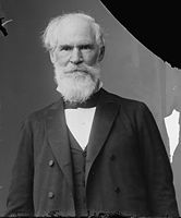
| Jonathan Jasper Wright (1840-1885) Jonathan Jasper Wright Jonathan Jasper Wright was an African American lawyer who served as a judge on the Supreme Court of the State of South Carolina during Reconstruction from 1870 to 1877.... |
 |
PA 29 & Cemetery St. (T361), Springville 41.69523°N 75.91872°W |
Roadside | African American, Government & Politics 19th Century, Professions & Vocations, Underground Railroad | |
| Joseph Smith |  |
US 11 near I-81 interchange, between Great Bend & Hallstead 41.96588°N 75.74065°W |
Roadside | Religion, Writers | |
| Joseph Smith | |
PA 171 at cemetery, near Skinner Rd., W of Oakland °N °W |
Roadside | Religion, Writers | |
| Mother Theresa Maxis Duchemin (1810-1892) | Turnpike St. (SR 1013) & Broad Ave., Susquehanna Depot °N °W |
Roadside | African American, Religion, Women | ||
| Pennsylvania Pennsylvania The Commonwealth of Pennsylvania is a U.S. state that is located in the Northeastern and Mid-Atlantic regions of the United States. The state borders Delaware and Maryland to the south, West Virginia to the southwest, Ohio to the west, New York and Ontario, Canada, to the north, and New Jersey to... |
 |
Lackawanna Trail (US 11), N of Great Bend, near NY state line 42.1475°N 75.7994°W |
Roadside | Government & Politics 17th Century, Government & Politics 18th Century, Religion, William Penn | |
| Starrucca Viaduct Starrucca Viaduct Starrucca Viaduct is a stone arch bridge that spans Starrucca Creek near Lanesboro, Pennsylvania, in the United States. At the time of its construction, the bridge was thought to be the most expensive railway bridge in the world, at a cost of $320,000 , and it was the largest stone rail viaduct in... |
SR 1009 at Lanesboro near viaduct (Missing) °N °W |
Roadside | Navigation, Railroads, Transportation | ||
| Susquehanna County Susquehanna County, Pennsylvania -Demographics:As of the census of 2000, there were 42,238 people, 16,529 households, and 11,785 families residing in the county. The population density was 51 people per square mile . There were 21,829 housing units at an average density of 26 per square mile... |
Monument Square at Maple St. & Lake Ave., adjacent to County Courthouse, Montrose 41.8339°N 75.87682°W |
City | African American, Government & Politics, Government & Politics 19th Century, Underground Railroad |
See also
- List of Pennsylvania state historical markers
- National Register of Historic Places listings in Susquehanna County, PennsylvaniaNational Register of Historic Places listings in Susquehanna County, PennsylvaniaThis is a list of the National Register of Historic Places listings in Susquehanna County, Pennsylvania.This is intended to be a complete list of the properties on the National Register of Historic Places in Susquehanna County, Pennsylvania, United States...