

List of Pennsylvania state historical markers in Snyder County
Encyclopedia

This is intended to be a complete list of the official state historical markers placed in Snyder County, Pennsylvania
Snyder County, Pennsylvania
Snyder County is a county located in the U.S. state of Pennsylvania. As of 2010, the population was 39,702. Snyder County was formed in 1855 from parts of Union County...
by the Pennsylvania Historical and Museum Commission
Pennsylvania Historical and Museum Commission
The Pennsylvania Historical and Museum Commission is the governmental agency of the Commonwealth of Pennsylvania responsible for the collection, conservation and interpretation of Pennsylvania's historic heritage...
(PHMC). The locations of the historical markers, as well as the latitude and longitude coordinates as provided by the PHMC's database, are included below when available. There are 15 historical markers located in Snyder County.
Historical markers
| Marker title | Image | Date dedicated | Location | Marker type | Topics |
|---|---|---|---|---|---|
| Albany Purchase | US 522/US 11 & 15, 1 mile N of Selinsgrove 40.82397°N 76.84705°W |
Roadside | Government & Politics, Government & Politics 18th Century | ||
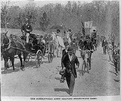
| Coxey's Army Coxey's Army Coxey's Army was a protest march by unemployed workers from the United States, led by the populist Jacob Coxey. They marched on Washington D.C. in 1894, the second year of a four-year economic depression that was the worst in United States history to that time. Officially named the Army of the... |
 |
814 N. Market St. (old U.S. 11 & 15), Selinsgrove 40.8088°N 76.85703°W |
Roadside | George Washington, Military, Military Post-Civil War | |
| Fort Augusta Fort Augusta Fort Augusta was a stronghold in Northumberland County, Pennsylvania, in the upper Susquehanna Valley from the time of the French and Indian War to the close of the American Revolution. The fort was erected by Col... |
U.S. 11, 5.9 miles NW of Selinsgrove near Northumberland Bridge (Missing) °N °W |
Roadside | Forts, French & Indian War, Military | ||
| Harris Ambush - PLAQUE | At the Old Bridge, 1/2 mile W of Selinsgrove °N °W |
Plaque | Early Settlement, French & Indian War, Native American, Navigation | ||
| Lock Number Seven | U.S. 15 & 11 at Mahantango Creek (Missing) °N °W |
Roadside | Canals, Navigation, Transportation | ||
| Penns Creek Massacre | SR 2017 (old U.S. 11 & 15) just N of Selinsgrove °N °W |
Roadside | Early Settlement, Native American | ||
| Penns Creek Massacre - PLAQUE | S end of Old Trail (just E of US 11 & 15) Penns Creek N of Selinsgrove °N °W |
Plaque | French & Indian War, Native American | ||
| Pennsylvania Canal (Susquehanna Division) Pennsylvania Canal (Susquehanna Division) The only canal of the Susquehanna Division of the Pennsylvania Canal ran along the west bank of the main stem of the Susquehanna River between a lock near the mouth of the Juniata River and the canal basin at Northumberland... |
U.S. 11 & 15 at Port Trevorton °N °W |
Roadside | Canals, Navigation, Transportation | ||
| Schoch Blockhouse | US 522 near RR crossing, at village of Kreamer 40.80378°N 76.97012°W |
Roadside | American Revolution, Military | ||
| Shikellamy Shikellamy Shikellamy , also known as Swatana, was an Oneida chief and overseer for the Iroquois confederacy. In his position as chief and overseer, Shikellamy served as a supervisor for the Six Nations, overseeing the Shawnee and Lenape tribes in central Pennsylvania along the Susquehanna River and... |
U.S. 11, 5.4 miles N of Selinsgrove entrance to Shikellamy State Park °N °W |
Roadside | Early Settlement, Native American | ||
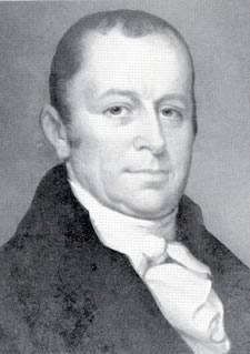
| Simon Snyder Simon Snyder Simon Snyder was the third Governor of the Commonwealth of Pennsylvania from 1808 to 1817. A Jeffersonian Democrat, he served three terms as speaker of the Pennsylvania House of Representatives before becoming governor... |
 |
121 N Marker St., Selinsgrove °N °W |
City | Ethnic & Immigration, Government & Politics, Government & Politics 19th Century, Governors | |
| Simon Snyder Mansion - PLAQUE Gov. Simon Snyder Mansion Gov. Simon Snyder Mansion is a historic home located at Selinsgrove in Snyder County, Pennsylvania. It is a -story stone house built in the early 19th century. It features a gable roof and two gable end chimneys. The building suffered a fire in 1874 after which a Victorian style porch and bay... |
121 N. Market St. (old US 11 & 15), Selinsgrove °N °W |
Plaque | Government & Politics 19th Century, Governors, Houses & Homesteads | ||
| Snyder County Snyder County, Pennsylvania Snyder County is a county located in the U.S. state of Pennsylvania. As of 2010, the population was 39,702. Snyder County was formed in 1855 from parts of Union County... |
County courthouse, 9 W. Market St. (US 522), Middleburg 40.79193°N 77.04648°W |
City | Government & Politics, Government & Politics 19th Century, Governors | ||
| Sunbury Sunbury, Pennsylvania Sunbury is a city in Northumberland County, Pennsylvania, United States. The city is located on the east bank of the Susquehanna River, just downstream of the confluence of its main and West branches. The population was 9,905 at the 2010 census... |
U.S. 11 & 15, 4 miles N of Selinsgrove °N °W |
Roadside | French & Indian War, Government & Politics, Government & Politics 18th Century, Military | ||
| Susquehanna University Susquehanna University Susquehanna University is a liberal arts college in Selinsgrove, Pennsylvania, United States, north of the state capital, Harrisburg.-Academics:... |
University Ave. near 18th St., Selinsgrove 40.79927°N 76.8732°W |
Roadside | Education, Religion |
See also
- List of Pennsylvania state historical markers
- National Register of Historic Places listings in Snyder County, PennsylvaniaNational Register of Historic Places listings in Snyder County, PennsylvaniaThis is a list of the National Register of Historic Places listings in Snyder County, Pennsylvania.This is intended to be a complete list of the properties and districts on the National Register of Historic Places in Snyder County, Pennsylvania, United States...