

List of Pennsylvania state historical markers in Potter County
Encyclopedia
This is intended to be a complete list of the official state historical markers placed in Potter County, Pennsylvania
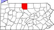
Potter County, Pennsylvania
Potter County is a county located in the U.S. state of Pennsylvania. It is in the Allegheny Plateau region. As of 2010, the population was 17,457. Its county seat is Coudersport. Potter County was named after James Potter, who was a general from Pennsylvania in the Continental Army during the...
by the Pennsylvania Historical and Museum Commission
Pennsylvania Historical and Museum Commission
The Pennsylvania Historical and Museum Commission is the governmental agency of the Commonwealth of Pennsylvania responsible for the collection, conservation and interpretation of Pennsylvania's historic heritage...
(PHMC). The locations of the historical markers, as well as the latitude and longitude coordinates as provided by the PHMC's database, are included below when available. There are 11 historical markers located in Potter County.
Historical markers
| Marker title | Image | Date dedicated | Location | Marker type | Topics |
|---|---|---|---|---|---|
| Allegheny River Allegheny River The Allegheny River is a principal tributary of the Ohio River; it is located in the Eastern United States. The Allegheny River joins with the Monongahela River to form the Ohio River at the "Point" of Point State Park in Downtown Pittsburgh, Pennsylvania... |
Pa. 49, 11 miles NE of Coudersport 41.85492°N 77.87556°W |
Roadside | Environment, Native American, Transportation | ||
| Austin Flood Disaster | Highway 872, 2 miles N of Austin 41.65197°N 78.08451°W |
Roadside | Environment | ||
| David Zeisberger David Zeisberger David Zeisberger was a Moravian clergyman and missionary among the Native Americans in the Thirteen Colonies... |
Pa. 49, 1 mile E of Harrison Valley 41.93431°N 77.63644°W |
Roadside | Early Settlement, Native American, Religion | ||
| David Zeisberger David Zeisberger David Zeisberger was a Moravian clergyman and missionary among the Native Americans in the Thirteen Colonies... |
Pa. 49, 11 miles NE of Coudersport near Raymond 41.8551°N 77.87522°W |
Roadside | Early Settlement, Native American, Religion | ||
| David Zeisberger David Zeisberger David Zeisberger was a Moravian clergyman and missionary among the Native Americans in the Thirteen Colonies... |
2nd St. (U.S. 6), Coudersport (Missing) 41.77445°N 78.01779°W |
Roadside | Early Settlement, Native American, Religion | ||
| David Zeisberger - PLAQUE David Zeisberger David Zeisberger was a Moravian clergyman and missionary among the Native Americans in the Thirteen Colonies... |
2nd St. (US 6) & Main Sts., County Courthouse, Coudersport 41.77473°N 78.02075°W |
Plaque | Early Settlement, Native American, Religion | ||
| Jersey Shore Pike | 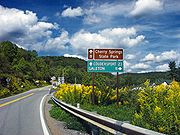 |
U.S. 6, 3.5 miles E of Coudersport 41.76001°N 77.96132°W |
Roadside | Roads, Transportation | |
| Lymansville | Junction U.S. 6 & Pa. 872, 2 miles E of Coudersport 41.77288°N 77.98395°W |
Roadside | Cities & Towns | ||
| Ole Bull's Colony | 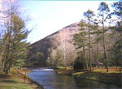 |
Cherry Spgs. Rd. (PA 44), near W Branch Rd., at Cherry Springs State Park Cherry Springs State Park Cherry Springs State Park is a Pennsylvania state park in Potter County, Pennsylvania, in the United States. The park was created from land within the Susquehannock State Forest, and is on Pennsylvania Route 44 in West Branch Township. Cherry Springs, named for a large stand of Black Cherry trees... 41.66113°N 77.82186°W |
Roadside | Ethnic & Immigration, Government & Politics, Government & Politics 19th Century | |
| Pennsylvania Pennsylvania The Commonwealth of Pennsylvania is a U.S. state that is located in the Northeastern and Mid-Atlantic regions of the United States. The state borders Delaware and Maryland to the south, West Virginia to the southwest, Ohio to the west, New York and Ontario, Canada, to the north, and New Jersey to... |
 |
In median opposite 391 Main St., Pa. 449, Genesee °N °W |
Roadside | Government & Politics, Government & Politics 17th Century, William Penn | |
| Potter County Potter County, Pennsylvania Potter County is a county located in the U.S. state of Pennsylvania. It is in the Allegheny Plateau region. As of 2010, the population was 17,457. Its county seat is Coudersport. Potter County was named after James Potter, who was a general from Pennsylvania in the Continental Army during the... |
 |
County Courthouse, 2nd & East Sts., Coudersport 41.77467°N 78.02025°W |
City | Government & Politics, Government & Politics 19th Century |
See also
- List of Pennsylvania state historical markers
- National Register of Historic Places listings in Potter County, PennsylvaniaNational Register of Historic Places listings in Potter County, PennsylvaniaThis is a list of the National Register of Historic Places listings in Potter County, Pennsylvania.This is intended to be a complete list of the properties and districts on the National Register of Historic Places in Potter County, Pennsylvania, United States...