

List of Pennsylvania state historical markers in Greene County
Encyclopedia
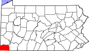
This is intended to be a complete list of the official state historical markers placed in Greene County, Pennsylvania
Greene County, Pennsylvania
-Demographics:As of the census of 2000, there were 40,672 people, 15,060 households, and 10,587 families residing in the county. The population density was 71 people per square mile . There were 16,678 housing units at an average density of 29 per square mile...
by the Pennsylvania Historical and Museum Commission
Pennsylvania Historical and Museum Commission
The Pennsylvania Historical and Museum Commission is the governmental agency of the Commonwealth of Pennsylvania responsible for the collection, conservation and interpretation of Pennsylvania's historic heritage...
(PHMC). The locations of the historical markers, as well as the latitude and longitude coordinates as provided by the PHMC's database, are included below when available. There are ten historical markers located in Greene County.
Historical markers
| Marker title | Image | Date dedicated | Location | Marker type | Topics |
|---|---|---|---|---|---|
| Fort Jackson | E High St. at Woodland Ave., Waynesburg (Missing) °N °W |
Roadside | American Revolution, Forts, Military | ||
| Fort Swan | n/a | Pa. 88, S of Dry Tavern (Missing) °N °W |
Roadside | Forts, Military | |
| Garard's Fort Corbly Family Massacre The Corbly Family Massacre refers to the massacre of members of the family of the Rev. John Corbly by Indians on May 10, 1782.The Corbly family lived one mile north of Garards Fort, in southwest Pennsylvania. The massacre occurred on Sunday morning, May 10, 1782, as the Corbly family traveled on... |
SR 2011, .6 miles E of Garard's Fort °N °W |
Roadside | American Revolution, Forts, Military, Native American | ||
| Greene Academy | Pa. 88, Carmichaels near intersection of Greene & Vine Sts. °N °W |
City | Education | ||
| Greene County Greene County, Pennsylvania -Demographics:As of the census of 2000, there were 40,672 people, 15,060 households, and 10,587 families residing in the county. The population density was 71 people per square mile . There were 16,678 housing units at an average density of 29 per square mile... |
County Courthouse, High St., Waynesburg 39.89635°N 80.18678°W |
City | Government & Politics, Government & Politics 18th Century | ||
| Monongahela College | Pa. 188 in Jefferson at Green & Pine Sts. °N °W |
Roadside | Education, Religion | ||
| Old Glassworks | SR 2014, Greensboro °N °W |
Roadside | Business & Industry, Glass | ||
| Rev. John Corbley Corbly Family Massacre The Corbly Family Massacre refers to the massacre of members of the family of the Rev. John Corbly by Indians on May 10, 1782.The Corbly family lived one mile north of Garards Fort, in southwest Pennsylvania. The massacre occurred on Sunday morning, May 10, 1782, as the Corbly family traveled on... |
SR 2011 between Fordyce and Garards Fort °N °W |
Roadside | Government & Politics, Government & Politics 18th Century, Military, Religion, Whiskey Rebellion | ||
| Ryerson's Blockhouse | Pa. 21 at Wind Ridge °N °W |
Roadside | Native American | ||
| Waynesburg College Waynesburg University Waynesburg University is a private, university located in Waynesburg, Pennsylvania, USA. The university offers graduate and undergraduate programs in more than 70 academic concentrations, and enrolls over 2,500 students, including approximately 1,500 undergraduates.Waynesburg University was... |
N Morris St. (US 19) at W College St., Monument Park in Waynesburg 39.89905°N 80.18845°W |
Roadside | Education, Religion |
See also
- List of Pennsylvania state historical markers
- National Register of Historic Places listings in Greene County, PennsylvaniaNational Register of Historic Places listings in Greene County, PennsylvaniaThis is a list of the National Register of Historic Places listings in Greene County, Pennsylvania.This is intended to be a complete list of the properties and districts on National Register of Historic Places in Greene County, Pennsylvania, United States...