

List of Pennsylvania state historical markers in Chester County
Encyclopedia
This is intended to be a complete list of the official state historical markers placed in Chester County, Pennsylvania
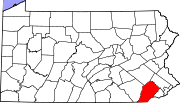
Chester County, Pennsylvania
-State parks:*French Creek State Park*Marsh Creek State Park*White Clay Creek Preserve-Demographics:As of the 2010 census, the county was 85.5% White, 6.1% Black or African American, 0.2% Native American or Alaskan Native, 3.9% Asian, 0.0% Native Hawaiian, 1.8% were two or more races, and 2.4% were...
by the Pennsylvania Historical and Museum Commission
Pennsylvania Historical and Museum Commission
The Pennsylvania Historical and Museum Commission is the governmental agency of the Commonwealth of Pennsylvania responsible for the collection, conservation and interpretation of Pennsylvania's historic heritage...
(PHMC). The locations of the historical markers, as well as the latitude and longitude coordinates as provided by the PHMC's database, are included below when available. There are 63 historical markers located in Chester County.
Historical markers
| Marker title | Image | Date dedicated | Location | Marker type | Topics |
|---|---|---|---|---|---|
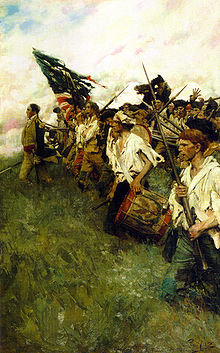
| American Light Infantry (The) Continental Army The Continental Army was formed after the outbreak of the American Revolutionary War by the colonies that became the United States of America. Established by a resolution of the Continental Congress on June 14, 1775, it was created to coordinate the military efforts of the Thirteen Colonies in... |
 |
US 1 (N side), 1 mile W of Chadds Ford °N °W |
Plaque | American Revolution, Military | |
| Ann Preston, M.D. (1813-1872) Ann Preston Ann Preston was an American doctor and educator.Born in West Grove, Pennsylvania as one of eight siblings, she was raised as a Quaker by a Quaker minister Amos and his wife Margaret Preston. Three of the children were girls, but Ann was the only one to survive until adulthood... |
225 State Rd., West Grove 39.8204°N 75.8127°W |
Roadside | African American, Medicine & Science, Religion, Underground Railroad, Women | ||
| Baptist Church in the Great Valley, The | SR 1007 (Valley Forge Rd.), .4 mile SE of Pa. 252, Tredyffrin Twp. 40.10007°N 75.46307°W |
Roadside | Religion | ||
| Battle of Brandywine Battle of Brandywine The Battle of Brandywine, also known as the Battle of the Brandywine or the Battle of Brandywine Creek, was fought between the American army of Major General George Washington and the British-Hessian army of General Sir William Howe on September 11, 1777. The British defeated the Americans and... |
 |
Pa. 842 at intersection SR 3061 SW of West Chester °N °W |
Roadside | American Revolution, Military | |
| Battle of Brandywine Battle of Brandywine The Battle of Brandywine, also known as the Battle of the Brandywine or the Battle of Brandywine Creek, was fought between the American army of Major General George Washington and the British-Hessian army of General Sir William Howe on September 11, 1777. The British defeated the Americans and... |
|
U.S. 1, 1 mile E of Kennett Square 39.8582°N 75.68982°W |
Roadside | American Revolution, George Washington, Military | |
| Battle of Brandywine Battle of Brandywine The Battle of Brandywine, also known as the Battle of the Brandywine or the Battle of Brandywine Creek, was fought between the American army of Major General George Washington and the British-Hessian army of General Sir William Howe on September 11, 1777. The British defeated the Americans and... |
|
U.S. 1, 1 mile E of Kennett Square °N °W |
Roadside | American Revolution, George Washington, Military | |
| Battle of Brandywine Battle of Brandywine The Battle of Brandywine, also known as the Battle of the Brandywine or the Battle of Brandywine Creek, was fought between the American army of Major General George Washington and the British-Hessian army of General Sir William Howe on September 11, 1777. The British defeated the Americans and... |
|
Pa. 926 at intersection SR 1001 (Birmingham Rd.) W of Darlington Corners, West Chester °N °W |
Roadside | American Revolution, Military | |
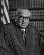
| Bayard Rustin Bayard Rustin Bayard Rustin was an American leader in social movements for civil rights, socialism, pacifism and non-violence, and gay rights.In the pacifist Fellowship of Reconciliation , Rustin practiced nonviolence... |
At the school, Lincoln & Montgomery Aves., West Chester °N °W |
City | African American, Civil Rights, Education | ||
| Birmingham Friends Meeting House Birmingham Friends Meetinghouse Birmingham Friends Meetinghouse is a historic Quaker meeting house at 1245 Birmingham Road in Birmingham Township, Chester County, Pennsylvania. The current meetinghouse was built in 1763 and added to the National Register in 1971. The building and the adjacent cemetery were near the center of... |
Wall of Meetinghouse, SR 2001 (Birmingham Rd.), .5 mile SE of PA 926, West Chester °N °W |
Plaque | American Revolution, Buildings, Medicine & Science, Military, Religion | ||
| Brandywine Mansion | 102 S. 1st Ave., Coatesville 39.98052°N 75.82168°W |
Roadside | Buildings, Business & Industry, Iron, Mansions & Manors | ||
| Chester County Chester County, Pennsylvania -State parks:*French Creek State Park*Marsh Creek State Park*White Clay Creek Preserve-Demographics:As of the 2010 census, the county was 85.5% White, 6.1% Black or African American, 0.2% Native American or Alaskan Native, 3.9% Asian, 0.0% Native Hawaiian, 1.8% were two or more races, and 2.4% were... |
County Courthouse, N. High St., West Chester 39.95997°N 75.60482°W |
City | American Revolution, Early Settlement, Government & Politics, Government & Politics 17th Century, Military, William Penn | ||
| Chester Springs | Pa. 113 at Chester Springs 40.0953°N 75.61762°W |
Roadside | American Revolution, George Washington, Medicine & Science, Military, Sports | ||
| Dilworthtown - PLAQUE |  |
SR 2001 (Birmingham Rd.) & Old Wilmington Pike, Dilworthtown 39.8996°N 75.5671°W |
Plaque | American Revolution, Military | |
| Dr. Charlotte Moore Sitterly (1898-1990) Charlotte Moore Sitterly Charlotte Emma Moore Sitterly was an American astronomer.Charlotte Moore was born in Ercildoun, Pennsylvania, a small village near Coatesville. She graduated from Swarthmore College in 1920 and went on to Princeton to assist Henry Norris Russell. During this time she worked at the Princeton... |
640 Buck Run Rd., East Fallowfield Township °N °W |
Roadside | Medicine & Science, Religion, Women | ||
| Duffy's Cut Mass Grave Duffy's Cut Duffy's Cut is the name given to a stretch of railroad tracks about 30 miles west of Philadelphia, USA, originally built for the Philadelphia and Columbia Railroad in the summer and fall of 1832. The line later became part of the Pennsylvania Railroad's Main Line... |
King Rd. at Sugartown Rd., Malvern 40.0335°N 75.5296°W |
Roadside | Business & Industry, Ethnic & Immigration, Labor, Medicine & Science, Railroads | ||
| Evan Pugh, Ph.D. Evan Pugh Evan Pugh was the first president of the Pennsylvania State University, serving from 1859 until his death from cholera in 1864. An agricultural chemist, he was responsible for securing Penn State's designation in 1863 as a land-grant institution under the Morrill Land Grant Act... |
Jordan Bank Elem. School, S. Fifth and Hodgson streets, Oxford °N °W |
City | Agriculture, Education, Environment, Medicine & Science, Professions & Vocations | ||
| Frederick Douglass (1818-1895) Frederick Douglass Frederick Douglass was an American social reformer, orator, writer and statesman. After escaping from slavery, he became a leader of the abolitionist movement, gaining note for his dazzling oratory and incisive antislavery writing... |
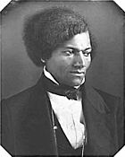 |
West Chester Univ. campus, between Library and Main Hall, facing High St. 39.95235°N 75.59732°W |
Roadside | African American, Civil Rights, Education, Government & Politics 19th Century, Military, Publishing | |
| G. Raymond Rettew |  |
Walnut & Chestnut Streets, West Chester 39.96182°N 75.60485°W |
Roadside | Business & Industry, Medicine & Science, Military, Military Post-Civil War, Professions & Vocations | |
| Gen. Anthony Wayne Anthony Wayne Anthony Wayne was a United States Army general and statesman. Wayne adopted a military career at the outset of the American Revolutionary War, where his military exploits and fiery personality quickly earned him a promotion to the rank of brigadier general and the sobriquet of Mad Anthony.-Early... |
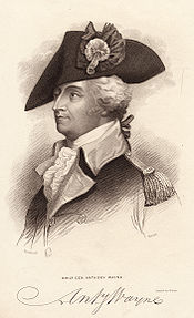 |
U.S. 30 at junction Pa. 252 E of Paoli 40.042°N 75.4767°W |
Roadside | American Revolution, French & Indian War, Military, Native American | |
| General Lafayette | 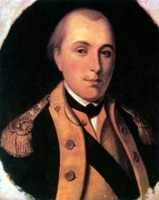 |
NW corner, N. Church & W. Lafayette Sts., West Chester 39.96523°N 75.61°W |
City | American Revolution, Military | |
| General Sir William Howe | 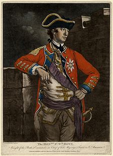 |
U.S. 202, 2.9 miles NE of Paoli (Missing) °N °W |
Roadside | American Revolution, Military | |
| Great Minquas Path Great Minquas Path Great Minquas Path was a 17th-century trade route that ran through southeastern Pennsylvania from the Susquehanna River, near Conestoga, to the Schuylkill River, opposite Philadelphia. The 80-mile east-west trail was the primary route for fur trading with the Minquas people... |
Business U.S. 322, 1 mile SE of West Chester 39.9483°N 75.5938°W |
Roadside | Native American, Paths & Trails, Transportation | ||
| Great Trail (The) - Minquas or Susquehanna Indians- PLAQUE | US 202 & 322, at Church Ave., 1/2 mile S of West Chester 39.9483°N 75.5938°W |
Plaque | Early Settlement, Ethnic & Immigration, Native American, Paths & Trails | ||
| Great Valley Mill | U.S. 202, 1.5 miles NE of Paoli (Missing) °N °W |
Roadside | Buildings, Business & Industry, Mills | ||
| Hopewell Historic District | Intersection of Hopewell & Lower Hopewell Roads, Lower Oxford & E. Nottingham Twps. °N °W |
Roadside | Agriculture, Business & Industry, Education | ||
| Hopewell Village | Pa. 345 at Warwick, just N of junction Pa. 23 39.7796°N 76.017°W |
Roadside | Business & Industry, Furnaces, Iron | ||
| Horace Pippin Horace Pippin Horace Pippin was a self-taught African-American painter. The injustice of slavery and American segregation figure prominently in many of his works.-Biography:... |
327 Gay St., West Chester 39.9583°N 75.61037°W |
City | African American, Artists | ||
| Hosanna Meeting House | Old U.S. 1 (Baltimore Pike) N of Lincoln University campus, Lower Oxford Twp. 39.8115°N 75.9253°W |
Roadside | African American, Houses & Homesteads, Religion, Underground Railroad | ||
| Ida Ella Ruth Jones (1874-1959) | Pa. 82 (Doe Run Rd.) at Rokeby Rd., East Fallowfield 39.93978°N 75.83278°W |
Roadside | African American, Artists, Women | ||
| Indian Hannah (1730-1802) - PLAQUE | PA 52 (E side), .2 mile N of junction US 1, Kennett Square 39.8724°N 75.6687°W |
Plaque | Government & Politics 18th Century, Native American, Religion | ||
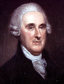
| John Beale Bordley John Beale Bordley John Beale Bordley, was a Maryland planter and judge.Son of Thomas Bordley, from Yorkshire, England 1694, attorney general for Maryland, and his second wife Ariana Vanderheyden.... |
 |
SR 3062 (Strasburg Rd.) just off Pa. 162, 1.6 miles W of Marshalltown °N °W |
Roadside | Agriculture, Environment, Invention, Professions & Vocations | |
| John F. Fritz | Pa. 41, 2.8 miles SE of Cochranville (Missing) °N °W |
Roadside | Business & Industry, Invention, Iron, Professions & Vocations, Steel | ||
| John G. Parke | 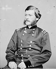 |
Business US 30 at Veterans Hospital, near N Cain Rd., E of Coatesville 39.98853°N 75.79345°W |
Roadside | Civil War, Environment, Government & Politics, Military, Professions & Vocations | |
| Joseph T. Rothrock |  |
NW corner, N. Church St. & W. Lafayette St., West Chester 39.9635°N 75.60922°W |
City | Environment, Medicine & Science, Professions & Vocations | |
| Lightfoot Mill (Mill at Anselma) Lightfoot Mill The Mill at Anselma is an archetypal small, 18th century custom grain mill in Chester Springs, Pennsylvania. It is probably the only surviving one in the United States with an intact colonial-era power transmission system... |
1730 Conestoga Rd. (W side of state hwy. 401), Chester Spgs. °N °W |
Roadside | Business & Industry, Mills | ||
| Lincoln Biography | 28 W. Market St., West Chester 39.95928°N 75.60515°W |
City | Abraham Lincoln, Government & Politics, Government & Politics 19th Century, Publishing | ||
| Lincoln University Lincoln University (Pennsylvania) Lincoln University is the United States' first degree-granting historically black university. It is located near the town of Oxford in southern Chester County, Pennsylvania. The university also hosts a Center for Graduate Studies in the City of Philadelphia. Lincoln University provides... |
 |
SR 3026 (old U.S. 1), 2 miles NE of Oxford 39.8106°N 75.9281°W |
Roadside | African American, Education | |
| Lynching of Zachariah Walker, The | Rt. 82 south, approx. 1/4 mile from Coatesville city limits °N °W |
Roadside | African American, Civil Rights, Government & Politics 20th Century | ||
| Minguannan Indian Town - PLAQUE | Intersection SR 3006 (Yeatman Station Rd.) & SR 3034 (London tract Rd.), 1.5 miles NE of Strickersville °N °W |
Plaque | Cities & Towns, Early Settlement, Government & Politics 17th Century, Native American, William Penn | ||
| Okehocking Indian Town - PLAQUE | PA 3 (West Chester Pike), .5 mile E of PA 926 & 4 miles W of Newtown Square °N °W |
Plaque | Cities & Towns, Early Settlement, Native American, William Penn | ||
| Osborne's Hill - PLAQUE | |
Sr 2001 (Birmingham Rd.) at driveway to Osborne Hill, 1 mile S of Strodes Mill °N °W |
Plaque | American Revolution, Military | |
| Pennhurst State School & Hospital | Schuylkill Rd. (PA 174) near Bridge St., Spring City °N °W |
Roadside | Civil Rights, Education, Government & Politics 20th Century | ||
| Pennsylvania Pennsylvania The Commonwealth of Pennsylvania is a U.S. state that is located in the Northeastern and Mid-Atlantic regions of the United States. The state borders Delaware and Maryland to the south, West Virginia to the southwest, Ohio to the west, New York and Ontario, Canada, to the north, and New Jersey to... |
 |
U.S. 1, approx. .6 miles from state line °N °W |
Roadside | Government & Politics, Government & Politics 17th Century, William Penn | |
| Pennsylvania Pennsylvania The Commonwealth of Pennsylvania is a U.S. state that is located in the Northeastern and Mid-Atlantic regions of the United States. The state borders Delaware and Maryland to the south, West Virginia to the southwest, Ohio to the west, New York and Ontario, Canada, to the north, and New Jersey to... |
|
Pa. 41, approx. .7 miles from state line °N °W |
Roadside | Government & Politics, Government & Politics 17th Century, William Penn | |
| Peter Bezellon | SR 3064 (West Chester Rd.) at Oak St., S end Coatesville 39.98185°N 75.8048°W |
City | Early Settlement, Native American, Professions & Vocations | ||
| Philadelphia & Lancaster Turnpike | E Lincoln Hwy. (Bus. Rt. 30), near Veterans Dr., Cain Twp., just E of Coatesville 39.98848°N 75.79208°W |
Roadside | Government & Politics, Roads, Transportation | ||
| Phoenix Iron Company | Main St., Phoenixville, near municipal parking lot and P.I.C. site °N °W |
City | Business & Industry, Civil War, Iron, Military | ||
| Queonemysing Indian Town (PLAQUE) | PA 100, ~.1 mile N of state line, and at Delaware County line (MISSING) °N °W |
Plaque | Cities & Towns, Early Settlement, Native American, William Penn | ||
| Samuel Barber Samuel Barber Samuel Osborne Barber II was an American composer of orchestral, opera, choral, and piano music. His Adagio for Strings is his most popular composition and widely considered a masterpiece of modern classical music... |
107 S. Church St., West Chester 39.57833°N 75.6045°W |
City | Music & Theater | ||
| Sconnelltown - PLAQUE | |
Near junction SR 3061 & 2001, just off PA 842 SW of West Chester 39.93555°N 75.62505°W |
Plaque | American Revolution, Military | |
| Springton Manor | SR 4023 (Springton Rd.) & Highspire Rd., 1 mile N of U.S. 322, Wallace Twp. °N °W |
Roadside | Government & Politics, Government & Politics 18th Century, Mansions & Manors, William Penn | ||
| Star of the West (Tent #6) | 113 S Adams St., West Chester 39.96137°N 75.59757°W |
City | African American, Women | ||
| Steyning Manor - PLAQUE | SR 3048 (old US 1) southbound, .5 mile W of Kennett Square °N °W |
Plaque | Government & Politics, Mansions & Manors, Native American, William Penn | ||
| The British Attack - PLAQUE | |
PA 926 at intersection SR 2001 (Birmingham Rd.), West Chester °N °W |
Plaque | American Revolution, Military | |
| Thomas B. Read Thomas Buchanan Read Thomas Buchanan Read , was an American poet and portrait painter.-Biography:Read was born in Chester County, Pennsylvania on March 12, 1822.... |
US 322 at Corner Ketch Lyndell Rd.(SR 4037), NW of Downingtown °N °W |
Roadside | Artists, Writers | ||
| Thomas McKean Thomas McKean Thomas McKean was an American lawyer and politician from New Castle, in New Castle County, Delaware and Philadelphia, Pennsylvania. During the American Revolution he was a delegate to the Continental Congress where he signed the United States Declaration of Independence and the Articles of... |
 |
Pa. 896 NW of Pa. 841, Franklin °N °W |
Roadside | Government & Politics, Government & Politics 18th Century, Governors | |
| Trimble's Ford - PLAQUE Trimbleville Historic District Trimbleville, also known as Trimble's Ford and the Trimbleville Historic District is a hamlet of about six homes, in southern Chester County, Pennsylvania, about two miles south of Marshallton.... |
SR 3023 (Camp Linden Rd.), .2 mile E of SR 3058, Marshallton 39.9341°N 75.68042°W |
Plaque | American Revolution, Military | ||
| Village of Valley Forge | Valley Forge Rd. (PA 23) near Owen Dr., at E end of village and Montgomery Co. line °N °W |
Roadside | Early Settlement, George Washington, Government & Politics, Government & Politics 18th Century, Iron | ||
| Village of Valley Forge | n/a | Valley Forge Rd. (PA 23) near Valley Park Rd., W end of village 40.10125°N 75.47447°W |
Roadside | American Revolution, Business & Industry, Cities & Towns, George Washington, Iron, Military | |
| Warwick Furnace | Pa. 23 between Warwick & Knauertown °N °W |
Roadside | Business & Industry, Furnaces, Iron | ||
| Whittier C. Atkinson (1893-1991) | 824 E Chestnut St., Coatesville °N °W |
City | African American, Medicine & Science | ||
| William Darlington William Darlington William Darlington was a member of the U.S. House of Representatives from Pennsylvania.William Darlington was born in Birmingham, Chester County, Pennsylvania. He attended Friends School at Birmingham and spent his youth on a farm... |
13 N. High St. between Market & Gay Sts., West Chester 39.96013°N 75.60477°W |
City | Environment, Government & Politics 19th Century, Medicine & Science, Professions & Vocations | ||
| Woman's Rights Convention of 1852 | 225 N. High St., West Chester 39.96203°N 75.6066°W |
City | Civil Rights, Education, Professions & Vocations, Women |
See also
- List of Pennsylvania state historical markers
- National Register of Historic Places listings in Chester County, PennsylvaniaNational Register of Historic Places listings in Chester County, PennsylvaniaFile:Map of Chester County Pennsylvania NRHP sites.PNG|thumb|right|Map of Chester County poly 77 194 71 185 77 176 100 130 101 113 100 100 97 89 128 71 187 24 216 5 222 7 229 4 237 3 253 11 258 15 262 13 262 9 264 8 277 32 278 34 282 33 281 30 282 26 286 26 289 35 291 43 300 50 300 55 298 58 299 63...