

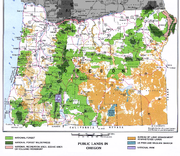
List of Oregon Wildernesses
Encyclopedia
Wilderness Act
The Wilderness Act of 1964 was written by Howard Zahniser of The Wilderness Society. It created the legal definition of wilderness in the United States, and protected some 9 million acres of federal land. The result of a long effort to protect federal wilderness, the Wilderness Act was signed...
in the U.S. state
U.S. state
A U.S. state is any one of the 50 federated states of the United States of America that share sovereignty with the federal government. Because of this shared sovereignty, an American is a citizen both of the federal entity and of his or her state of domicile. Four states use the official title of...
of Oregon
Oregon
Oregon is a state in the Pacific Northwest region of the United States. It is located on the Pacific coast, with Washington to the north, California to the south, Nevada on the southeast and Idaho to the east. The Columbia and Snake rivers delineate much of Oregon's northern and eastern...
.
| Wilderness name | acres | designated | administered by | notes |
|---|---|---|---|---|
| Badger Creek Badger Creek Wilderness The Badger Creek Wilderness is a wilderness area located east of Mount Hood in the northwestern Cascades of Oregon, United States. It is one of six designated wilderness areas in the Mount Hood National Forest; the others being Mark O. Hatfield, Salmon-Huckleberry, Mount Hood, Mount Jefferson,... |
24,000 | 1984 | USFS | |
| Black Canyon | 13,400 | 1984 | USFS | |
| Boulder Creek Boulder Creek Wilderness The Boulder Creek Wilderness is a wilderness area located in the Umpqua National Forest in the southern Cascade Range of Oregon, United States. It was designated by the United States Congress in 1984 and comprises .... |
19,100 | 1984 | USFS | |
| Bridge Creek Bridge Creek Wilderness Bridge Creek Wilderness is a wilderness area located in the Ochoco Mountains of central Oregon, within the Ochoco National Forest. It was established in 1984 and comprises , making it one of the smallest Wilderness areas in the state.-Topography:... |
5,400 | 1984 | USFS | |
| Bull of the Woods Bull of the Woods Wilderness The Bull of the Woods Wilderness is a wilderness area located in the Mount Hood National Forest in the northwestern Cascades of Oregon, United States. It was created in 1984 and consists of including prime low-elevation old growth forest, about a dozen lakes of at least and many large creeks and... |
27,427 | 1984 | USFS | |
| Clackamas Clackamas Wilderness The Clackamas Wilderness is made up of five different tracts of lands with no roads, scattered both left and right of the Clackamas River, approximately 50 miles down. These areas include Big Bottom, Memaloose Lake, Clackamas Canyon, Sisi Butte and South Fork Clackamas. The Clackamas Wilderness... |
9,470 | 2009 | USFS | |
| Copper Salmon Copper Salmon Wilderness The Copper Salmon Wilderness is a protected wilderness area in the Southern Oregon Coast Range and is part of the Rogue River – Siskiyou National Forest... |
13,700 | 2009 | USFS | |
| Cummins Creek Cummins Creek Wilderness The Cummins Creek Wilderness is a wilderness area in the Siuslaw National Forest on the Oregon coast. It is one of three wilderness areas created in the Siuslaw in 1984, along with Drift Creek and Rock Creek... |
9,173 | 1984 | USFS | |
| Diamond Peak Diamond Peak Wilderness The Diamond Peak Wilderness is a wilderness area straddling the Cascade crest and includes the Diamond Peak Volcano. It is located within two National Forests - the Willamette National Forest on the west and the Deschutes National Forest on the east.... |
54,185 | 1964 | USFS | |
| Drift Creek Drift Creek Wilderness Drift Creek Wilderness is a wilderness area in the Siuslaw National Forest on the Oregon Coast. It was created in 1984, along with two other small wilderness areas in the Forest - Cummins Creek Wilderness and Rock Creek Wilderness. The elevation of Drift Creek ranges from , and is characterized... |
5,798 | 1984 | USFS | |
| Eagle Cap Eagle Cap Wilderness Eagle Cap Wilderness is a wilderness area located in the Wallowa Mountains of northeastern Oregon , within the Wallowa–Whitman National Forest. The Wilderness was established in 1940. In 1964, it was included in the National Wilderness Preservation System... |
350,461 | 1964 | USFS | |
| Gearhart Mountain Gearhart Mountain Wilderness Gearhart Mountain Wilderness is a wilderness area located within the Fremont National Forest in Lake County and Klamath County, south-central Oregon. This area was established in 1943 as a Wild Area and designated as Wilderness with the Wilderness Act of 1964. In 1984, an additional were added... |
22,809 | 1964 | USFS | |
| Grassy Knob Grassy Knob Wilderness Grassy Knob Wilderness is a wilderness area in the Klamath Mountains of southwestern Oregon, within the Rogue River-Siskiyou National Forest. It was designated wilderness by the United States Congress in 1984 and now comprises a total of... |
17,200 | 1984 | USFS | |
| Hells Canyon | 214,944 (total) 131,133 (Oregon) |
1975, June 26, 1984 | BLM+USFS | |
| Kalmiopsis Kalmiopsis Wilderness Kalmiopsis Wilderness is a wilderness area in the Klamath Mountains of southwestern Oregon, within the Rogue River-Siskiyou National Forest. It was designated wilderness by the United States Congress in 1964 and now comprises a total of... |
179,755 | 1964 | USFS | |
| Lower White River Lower White River Wilderness Lower White River Wilderness is a protected wilderness in the US State of Oregon on the southern part of Mount Hood. In 2009, Congress designated the area a National Wilderness preserve.The White River rises from White River Glacier in White River Canyon... |
2,870 | 2009 | BLM+USFS | |
| Mark O. Hatfield Mark O. Hatfield Wilderness The Mark O. Hatfield Wilderness is a wilderness area located on the northern side of Mount Hood in the northwestern Cascades of the U.S. state of Oregon, near the Columbia River Gorge and within Mount Hood National Forest... |
39,000 | 1984 | USFS | |
| Menagerie Menagerie Wilderness The Menagerie Wilderness is a designated wilderness area located near Mount Washington in the central Cascade Range of Oregon. It is situated near Highway 20 within the Willamette National Forest and is managed by the US Forest Service.- Geography :... |
4,800 | 1984 | USFS | |
| Middle Santiam Middle Santiam Wilderness The Middle Santiam Wilderness is a wilderness area located near Mount Washington in the central Cascade Range of Oregon, U.S., within the Willamette National Forest.-Topography:... |
7,500 | 1984 | USFS | |
| Mill Creek Mill Creek Wilderness Mill Creek Wilderness is a wilderness area located in the Ochoco National Forest of central Oregon. It was established in 1984 and comprises . Of the three wilderness areas in the Ochoco National Forest - Mill Creek, Bridge Creek, and Black Canyon - Mill Creek is the largest and most heavily... |
17,400 | 1984 | USFS | |
| Monument Rock Monument Rock Wilderness The Monument Rock Wilderness Area is a wilderness area within the Malheur and Wallowa-Whitman National Forests in Blue Mountains of eastern Oregon. It was designated by the United States Congress in 1984 and comprises... |
19,650 | 1984 | USFS | |
| Mount Hood Mount Hood Wilderness The Mount Hood Wilderness is a protected wilderness area inside the Mount Hood National Forest which is located in the U.S. state of Oregon. The area, covering , includes the peak of Mount Hood and its upper slopes, and ranges from temperate rain forests at the lower elevations, to glaciers and... |
47,160 | 1964 | USFS | |
| Mount Jefferson Mount Jefferson Wilderness The Mount Jefferson Wilderness is a wilderness area located on and around Mount Jefferson in the central Cascade Range of Oregon in the United States. It is situated where the Willamette, Deschutes, and Mount Hood National Forests meet... |
107,008 | 1968 | USFS | |
| Mount Thielsen Mount Thielsen Wilderness The Mount Thielsen Wilderness is a wilderness area located on and around Mount Thielsen in the southern Cascade Range of Oregon, United States. It is located within the Deschutes, Umpqua, and Winema National Forests... |
54,267 | 1984 | USFS | |
| Mount Washington Mount Washington Wilderness The Mount Washington Wilderness is a wilderness area located on and around Mount Washington in the central Cascade Range of Oregon in the United States. The Wilderness Area was established in 1964 and comprises of the Willamette and Deschutes National Forests... |
52,738 | 1964 | USFS | |
| Mountain Lakes Mountain Lakes Wilderness The Mountain Lakes Wilderness is a wilderness area located in the Fremont–Winema National Forests in the southern Cascade Range of Oregon, USA. It surrounds a cluster of four overlapping shield volcanoes, the highest of which is Aspen Butte... |
23,071 | 1964 | USFS | |
| North Fork John Day North Fork John Day Wilderness The North Fork John Day Wilderness is a wilderness area within the Umatilla and Wallowa-Whitman National Forests, in the Blue Mountains of northeastern Oregon.... |
121,352 | 1984 | USFS | |
| North Fork Umatilla North Fork Umatilla Wilderness The North Fork Umatilla Wilderness is a wilderness area located inside the Umatilla National Forest, in the Blue Mountains of northeastern Oregon... |
20,435 | 1984 | USFS | |
| Opal Creek Opal Creek Wilderness The Opal Creek Wilderness is a wilderness area located in the Willamette National Forest in the U.S. state of Oregon, on the border of the Mount Hood National Forest... |
20,733 | 1996 | USFS | |
| Oregon Islands | 925.06 | October 23, 1970, October 11, 1978, November 12, 1996 | USFWS | |
| Oregon Badlands Oregon Badlands Wilderness Oregon Badlands Wilderness is a wilderness area located east of Bend in Deschutes and Crook counties in the U.S. state of Oregon. It was created by the Omnibus Public Land Management Act of 2009, which was signed into law by President Barack Obama on March 30, 2009.The wilderness is situated on... |
29,301 | 2009 | BLM | |
| Red Buttes Red Buttes Wilderness The Red Buttes Wilderness is a wilderness area in Rogue River – Siskiyou National Forest in the U.S. states of Oregon and California. It comprises , approximately of which is located in California, and in Oregon... |
19,940 (total) 3,750 (Oregon) |
1984 | USFS | |
| Roaring River Roaring River Wilderness Roaring River Wilderness is a wilderness area in the Mount Hood National Forest in Clackamas County, Oregon, United States. Southwest of Mount Hood, Oregon's tallest mountain, the area was created in 2009... |
36,500 | 2009 | USFS | |
| Rock Creek Rock Creek Wilderness The Rock Creek Wilderness is a wilderness area comprising within the Siuslaw National Forest on the Oregon Coast. It was created in 1984, along with the Drift Creek Wilderness and Cummins Creek Wilderness.-Topography:... |
7,486 | 1984 | USFS | |
| Rogue–Umpqua Divide | 33,200 | 1984 | USFS | |
| Salmon–Huckleberry | 44,560 | 1984 | USFS | |
| Sky Lakes Sky Lakes Wilderness The Sky Lakes Wilderness is a wilderness area located in the Rogue River-Siskiyou and Winema National Forests in the southern Cascade Range of Oregon, U.S.. It comprises . of the area are located in the Rogue River-Siskiyou National Forest, and located in the Winema National Forest... |
116,300 | 1984 | USFS | |
| Soda Mountain Soda Mountain Wilderness The Soda Mountain Wilderness is a protected wilderness area inside the Cascade–Siskiyou National Monument located in the U.S. state of Oregon adjacent to the California state border... |
23,000 | 2009 | BLM | |
| Spring Basin Spring Basin Wilderness Spring Basin Wilderness is a wilderness area located near the town of Clarno in the U.S. state of Oregon. It was created by the Omnibus Public Land Management Act of 2009, which was signed into law by President Barack Obama on March 30, 2009.... |
6,382 | 2009 | BLM | |
| Steens Mountain Steens Mountain Wilderness Steens Mountain Wilderness is a wilderness area surrounding a portion of Steens Mountain of southeastern Oregon, U.S. The reserve falls within the Steens Mountain Cooperative Management and Protection Area . Both the reserve and the CMPA are administered by the Bureau of Land Management. The... |
170,025 | October 30, 2000 | BLM | |
| Strawberry Mountain Strawberry Mountain Wilderness Strawberry Mountain Wilderness is a wilderness area of the Strawberry Mountain Range, within Malheur National Forest in the Blue Mountains of east Oregon. The area comprises , including mountain peaks and several lakes, and contains more than of hiking trails... |
69,350 | 1964 | USFS | |
| Table Rock Table Rock Wilderness The Table Rock Wilderness is a small pocket wilderness designated in 1984in the western Cascade Mountains in northwestern Oregon, United States. The wilderness area protects of forest in the historic Molalla River–Pudding River drainage basin, some southeast of Molalla, Oregon and southeast of... |
5,500 | June 26, 1984 | BLM | |
| Three Arch Rocks | 15 | October 23, 1970 | USFWS+USFS | first NWR west of Mississippi 1907 |
| Three Sisters Three Sisters Wilderness The Three Sisters Wilderness is a wilderness area in the Cascade Range, within the Willamette and Deschutes National Forests in Oregon. It comprises 286,708 acres , making it the second largest Wilderness area in Oregon... |
286,708 | 1964 | USFS | |
| Waldo Lake Waldo Lake Wilderness Waldo Lake Wilderness is a wilderness area surrounding Waldo Lake in the central Oregon Cascades. It is located within the Willamette National Forest... |
39,200 | 1984 | USFS | |
| Wenaha–Tucannon | 177,423 (total) 66,375 (Oregon) |
1978 | USFS | |
| Wild Rogue Wild Rogue Wilderness The Wild Rogue Wilderness is a wilderness area surrounding the eighty-four mile Wild and Scenic portion of the Rogue River in southwestern Oregon, U.S. to protect the watershed. The Wilderness was established in 1987 and now comprises... |
35,818 | February 24, 1978 | BLM+USFS | |
| Total (acres) | 2,395,390.06 (Oregon) | 2,606,439.06 (total) | ||
| Total (square miles) | 3742.8 (Oregon) | 4072.56 (total) | ||
| Total (square km) | 9693.84 (Oregon) | 10547.93 (total) |