

List of National Natural Landmarks in Virginia
Encyclopedia
From List of National Natural Landmarks, these are the National Natural Landmark
s in Virginia
, United States. There are 12 in total, X are lakes or pond, Y are forests, Z are other.
National Natural Landmark
The National Natural Landmark program recognizes and encourages the conservation of outstanding examples of the natural history of the United States. It is the only natural areas program of national scope that identifies and recognizes the best examples of biological and geological features in...
s in Virginia
Virginia
The Commonwealth of Virginia , is a U.S. state on the Atlantic Coast of the Southern United States. Virginia is nicknamed the "Old Dominion" and sometimes the "Mother of Presidents" after the eight U.S. presidents born there...
, United States. There are 12 in total, X are lakes or pond, Y are forests, Z are other.
| Name | Image | Date | Location | County | Description | |
|---|---|---|---|---|---|---|
| 1 | Butler Cave- Breathing Cave | Bath Bath County, Virginia As of the census of 2000, there were 5,048 people, 2,053 households, and 1,451 families residing in the county. The population density was 10 people per square mile . There were 2,896 housing units at an average density of 5 per square mile... |
Two major cave systems that contain a 40-foot waterfall, a natural bridge, unusually fine crystalline formations, and an underground lake. | |||
| 2 | Caledon Natural Area Caledon Natural Area The Caledon Natural Area is a state park located in King George, Virginia. The property was initially owned by the Alexander brothers, founders of the city of Alexandria, and was established in 1659 as Caledon Plantation. Ownership passed, in 1974, to the Commonwealth of Virginia... |
King George King George County, Virginia As of the census of 2010, there were 23,584 people, 9,411 households, and 4,525 families residing in the county. The population density was 93 people per square mile . There were 6,820 housing units at an average density of 38 per square mile... |
One of the best examples of oak-tulip poplar-dominated virgin upland forest in the country. | |||
| 3 | Charles C. Steirly Natural Area | Sussex Sussex County, Virginia As of the census of 2000, there were 12,504 people, 4,126 households, and 2,809 families residing in the county. The population density was 26 people per square mile . There were 4,653 housing units at an average density of 10 per square mile... |
A small essentially virgin stand of climax bald cypress-water tupelo swamp forest. | |||
| 4 | Grand Caverns Grand Caverns Grand Caverns, formerly known as Weyer's Cave, is located in the central Shenandoah Valley near the town of Grottoes, Virginia, USA. A limestone cavern, it claims the distinction of being America's oldest show cave, in operation since 1806.... |
 |
Augusta Augusta County, Virginia As of the census of 2000, there were 65,615 people, 24,818 households, and 18,911 families residing in the county. The population density was 68 people per square mile . There were 26,738 housing units at an average density of 28 per square mile... |
Contains unique shield formations as well as draperies, flowstone, stalactites and stalagmites. | ||
| 5 | Great Dismal Swamp Great Dismal Swamp The Great Dismal Swamp is a marshy area on the Coastal Plain Region of southeastern Virginia and northeastern North Carolina between Norfolk, Virginia, and Elizabeth City, North Carolina in the United States. It is located in parts of southern Chesapeake and Suffolk in Virginia, as well as northern... |
Suffolk City Suffolk, Virginia Suffolk is the largest city by area in Virginia, United States, and is located in the Hampton Roads metropolitan area. As of the 2010 census, the city had a total population of 84,585. Its median household income was $57,546.-History:... |
A remnant of the original Great Dismal Swamp. | |||
| 6 | Luray Caverns Luray Caverns Luray Caverns, originally called Luray Cave, is a large, celebrated commercial cave just west of Luray, Virginia, USA, which has drawn many visitors since its discovery in 1878. The underground cavern system is generously adorned with speleothems... |
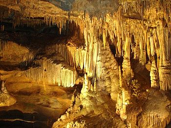 |
Page Page County, Virginia As of the census of 2000, there were 23,177 people, 9,305 households, and 6,634 families residing in the county. The population density was 74 people per square mile . There were 10,557 housing units at an average density of 34 per square mile... |
A cave ornately decorated with cascades, columns, stalactites, stalagmites and pools. | ||
| 7 | Montpelier Forest | Orange Orange County, Virginia As of the census of 2000, there were 25,881 people, 10,150 households, and 7,470 families residing in the county. The population density was 76 people per square mile . There were 11,354 housing units at an average density of 33 per square mile... |
A mature forest dominated primarily by tulip poplar and spicebush. | |||
| 8 | Rich Hole | Rockbridge Rockbridge County, Virginia As of the census of 2000, there were 20,808 people, 8,486 households, and 6,075 families residing in the county. The population density was 35 people per square mile . There were 9,550 housing units at an average density of 16 per square mile... |
An outstanding example of a “cove” hardwood forest. | |||
| 9 | Seashore Natural Area First Landing State Park First Landing State Park offers recreational opportunities at Cape Henry in the independent city of Virginia Beach, Virginia.... |
Virginia Beach Virginia Beach, Virginia Virginia Beach is an independent city located in the Hampton Roads metropolitan area of Virginia, on the Atlantic Ocean at the mouth of the Chesapeake Bay... |
Contains parallel dunes that are densely wooded with two distinct forest types of semitropical character. | |||
| 10 | Virginia Coast Reserve Virginia Coast Reserve The Virginia Coast Reserve is a biosphere reserve created by The Nature Conservancy in the early 1970s. It consists of 14 barrier islands along the Atlantic coast of the Virginia portion of the Delmarva Peninsula, including Parramore Island, Hog Island, Virginia, Smith Island, Virginia, Assawoman... |
Accomack Accomack County, Virginia As of the census of 2010, there were 33,164 people, 15,299 households, and 10,388 families residing in the county. The population density was 84 people per square mile . There were 19,550 housing units at an average density of 43 per square mile... , Northampton Northampton County, Virginia As of the census of 2010, there were 12,389 people, 5,321 households, and 3,543 families residing in the county. The population density was 63 people per square mile . There were 6,547 housing units at an average density of 32 per square mile... |
Relatively undisturbed barrier island-lagoon complex. A refuge for migratory shorebirds, waterfowl and colonial nesting birds. | |||