

List of National Natural Landmarks in Texas
Encyclopedia
From List of National Natural Landmarks, these are the National Natural Landmark
s in Texas
. There are 20 in total, X are lakes or pond, Y are forests, Z are other.
National Natural Landmark
The National Natural Landmark program recognizes and encourages the conservation of outstanding examples of the natural history of the United States. It is the only natural areas program of national scope that identifies and recognizes the best examples of biological and geological features in...
s in Texas
Texas
Texas is the second largest U.S. state by both area and population, and the largest state by area in the contiguous United States.The name, based on the Caddo word "Tejas" meaning "friends" or "allies", was applied by the Spanish to the Caddo themselves and to the region of their settlement in...
. There are 20 in total, X are lakes or pond, Y are forests, Z are other.
| Name | Image | Date | Location | County | Description | |
|---|---|---|---|---|---|---|
| 1 | Attwater Prairie Chicken Preserve Attwater Prairie Chicken National Wildlife Refuge Attwater Prairie Chicken National Wildlife Refuge, is a federally protected refugium encompassing one of the largest remnants of coastal prairie habitat remaining in southeast Texas, United States and home to one of the last populations of the critically endangered Attwater's Prairie Chicken, a... |
Colorado | Contains the only significant segment of gulf coastal prairie. | |||
| 2 | Bayside Resaca Area | Cameron Cameron County, Texas Cameron County is the southernmost county located in the U.S. state of Texas. In 2010, its population was 406,220. Its county seat is Brownsville. Cameron was founded in 1848... |
Contains an excellent example of a resaca Resaca Resaca may refer to:* Resaca, Georgia* Resaca, Ohio* Battle of Resaca -- an inconclusive battle of the American Civil War fought in May 1864* Resaca , channels in the Rio Grande basin of southernmost Texas... . |
|||
| 3 | Catfish Creek (Texas) Catfish Creek (Texas) -References:**USGS Hydrologic Unit Map - State of Texas... |
Anderson Anderson County, Texas Anderson County is a county located in the U.S. state of Texas. As of 2000, the population was 55,109. Its county seat is Palestine. Anderson county was organized in 1846, and is named in honor of Kenneth L. Anderson who had been Vice President of the Republic of Texas.-Geography:According to the... |
One of the few remaining undisturbed riparian habitats in the western Gulf Coastal Plain | |||
| 4 | Caverns of Sonora Caverns of Sonora The Caverns of Sonora, a National Natural Landmark, is a unique cave located west of the small city of Sonora, the seat of Sutton County, Texas. It is a world-class cave because of its stunning array of calcite crystal formations, especially helictites. These helictites are found in extreme... |
 |
Sutton | Contains unusual formations, such as bladed helictites and coralloid growths | ||
| 5 | Devil's Sink hole | Edwards | A deep, bell-shaped, collapsed limestone sink. | |||
| 6 | Dinosaur Valley Dinosaur Valley State Park - History :Dinosaur Valley State Park, located just northwest of Glen Rose in Somervell County, is a scenic park set astride the Paluxy River. The land for the park was acquired from private owners under the State Parks Bonds Program during 1968 and opened to the public in 1972... |
Somervell Somervell County, Texas There were 2,438 households out of which 37.40% had children under the age of 18 living with them, 61.70% were married couples living together, 9.60% had a female householder with no husband present, and 24.50% were non-families. 21.30% of all households were made up of individuals and 9.20% had... |
The only known source of distinct and full-grown sauropod footprints. | |||
| 7 | Ezell's Cave | Hays Hays County, Texas Hays County is a county located on the Edwards Plateau in the U.S. state of Texas. In 2010, its official population had reached 157,107. It is named for John Coffee Hays, a Texas Ranger and Mexican-American War officer. The seat of the county is San Marcos.... |
Houses at least 36 species of cave fauna. | |||
| 8 | Enchanted Rock Enchanted Rock Enchanted Rock is an enormous pink granite pluton rock formation located in the Llano Uplift approximately north of Fredericksburg, Texas, USA and south of Llano, Texas. Enchanted Rock State Natural Area, which includes Enchanted Rock and surrounding land, spans the border between Gillespie... |
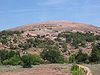 |
Gillespie Gillespie County, Texas Gillespie County is a county located on the Edwards Plateau in the U.S. state of Texas. In 2010, its population was 24,837. It is located in the heart of the Texas Hill Country. Gillespie is named for Robert Addison Gillespie, who came to Texas in 1837. He was a Texas Ranger, an Indian fighter, a... , Llano Llano County, Texas Llano County is a county located on the Edwards Plateau in the U.S. state of Texas. In 2010, its population was 19, 301. Its county seat is Llano, and the county is named for the Llano River.... |
A classic illustration of a batholith Batholith A batholith is a large emplacement of igneous intrusive rock that forms from cooled magma deep in the Earth's crust... and of the exfoliation process. |
||
| 9 | Fort Worth Nature Center and Refuge | Tarrant Tarrant County, Texas Tarrant County is a county located in the U.S. state of Texas. As of the 2010 U.S. Census, it had a population of 1,809,034. Its county seat is Fort Worth. Tarrant County is the sixteenth most populous county in the United States and the third most populous in Texas. The county is named in honor... |
Contains outstanding examples of the unique oak-hickory forest associations called cross timbers. | |||
| 10 | Greenwood Canyon | Montague Montague County, Texas As of the census of 2000, there were 19,117 people, 7,770 households, and 5,485 families residing in the county. The population density was 20 people per square mile . There were 9,862 housing units at an average density of 11 per square mile... |
A rich source of early Cretaceous mammalian fossils. | |||
| 11 | High Plains Natural Area Buffalo Lake National Wildlife Refuge Not to be confused with Buffalo Lake National Wildlife Refuge Once buffalo grazed the shortgrass prairie seen today at Buffalo Lake National Wildlife Refuge in Randall County of the Texas Panhandle. Once a lake reflected the clouds. The buffalo vanished. The lake has dried... |
Randall | One of the best developed, least disturbed natural shortgrass climax communities remaining in the Great Plains. | |||
| 12 | Little Blanco River Bluff | Blanco Blanco County, Texas Blanco County is a county located on the Edwards Plateau in the U.S. state of Texas. As of 2010, the population is 10,497. Its county seat is Johnson City. Blanco is named for the Blanco River which traverses the county. The State of Texas formed Blanco County in 1858 from portions of Burnet,... |
An unspoiled example of the limestone bluff communities of the Edwards Plateau Edwards Plateau The Edwards Plateau is a region of west-central Texas which is bounded by the Balcones Fault to the south and east, the Llano Uplift and the Llano Estacado to the north, and the Pecos River and Chihuahuan Desert to the west. San Angelo, Austin, San Antonio and Del Rio roughly outline the area... . |
|||
| 13 | Longhorn Cavern | Burnet Burnet County, Texas Burnet County is a county located on the Edwards Plateau in the U.S. state of Texas. As of 2000, the population was 34,147. The 2008 Census Bureau Estimate was 44,488. Its county seat is Burnet. Burnet is named for David Gouverneur Burnet, the first president of the Republic of Texas... |
An outstanding example of cave features formed during the phreatic Phreatic The term phreatic is used in Earth sciences to refer to matters relating to ground water below the water table . The term 'phreatic surface' indicates the location where the pore water pressure is under atmospheric conditions... phase of development. |
|||
| 14 | Lost Maples State Natural Area Lost Maples State Natural Area Lost Maples State Natural Area is a state park in the Edwards Plateau of Texas, United States.- Location :Lost Maples State Natural Area is located about north of Vanderpool, Texas and west of San Antonio... |
Bandera Bandera County, Texas Bandera County, formed in 1856 from Bexar and Uvalde counties, is a county located on the Edwards Plateau in the U.S. state of Texas. As of 2000, the population is 17,645. Its county seat is Bandera. Bandera is named for the Spanish word for flag... , Real |
An excellent illustration of Edwards Plateau flora and fauna. | |||
| 15 | Muleshoe National Wildlife Refuge Muleshoe National Wildlife Refuge Muleshoe National Wildlife Refuge is the oldest National Wildlife Refuge in the state of Texas, having been established in 1935. It is located about twenty miles south of Muleshoe, the seat of Bailey County... |
 |
Bailey Bailey County, Texas Bailey County is a county located in the U.S. state of Texas. As of 2010, the population is 7,165. Its county seat is Muleshoe. Bailey is named for Peter James Bailey, a defender of the Alamo... |
Saline lake beds, and shortgrass grama grasslands characteristic of the high plains. | ||
| 16 | Odessa Meteor Crater Odessa Meteor Crater The Odessa Meteor Crater is a meteorite crater in the southwestern part of Ector County, southwest of the city of Odessa, Texas, United States. It is located approximately 3 miles south of I-20 at FM 1936 south... |
Ector | Contains two meteorite impact craters. The largest is 550 feet (167.6 m) in diameter. | |||
| 17 | Palo Duro Canyon State Park | 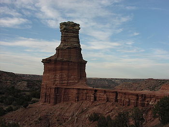 |
Armstrong Armstrong County, Texas Armstrong County is a county located in the U.S. state of Texas, and was formed in 1876 from Bexar County. It is part of the Amarillo metropolitan area. As of 2000, the population is 2,148. Its county seat is Claude. Armstrong is named for one of several Texas pioneer families named Armstrong... , Randall |
Spectacular canyon that is an excellent example of a landform created by running water. | ||
| 18 | Santa Ana National Wildlife Refuge Santa Ana National Wildlife Refuge Santa Ana National Wildlife Refuge is a refuge situated along the banks of the Rio Grande in Hidalgo County, Texas south of Alamo, Texas. It was established for the protection of migratory birds in 1943... |
Hidalgo Hidalgo County, Texas Hidalgo County is a county located in the U.S. state of Texas. Located in the Rio Grande Valley of South Texas, Hidalgo County is one of the fastest-growing counties in the United States, and is the seventh most-populous county in Texas. Its population in 2010 was 774,769, a 35% increase from 2000... |
A living museum of the lowland forested area of the Lower Rio Grande Valley. | |||
| 19 | Natural Bridge Caverns Natural Bridge Caverns Natural Bridge Caverns are the largest known commercial caverns in the state of Texas.The name was derived from the 20 m natural limestone slab bridge that spans the amphitheater setting of the cavern's entrance... |
Comal Comal County, Texas Comal County is a county located on the Edwards Plateau in the U.S. state of Texas. In 2010, its population was 108,472. Its seat is New Braunfels.Comal County is part of the San Antonio Metropolitan Statistical Area.-History Timeline:... |
A multilevel cavern system containing unusual speleothems and intricate helictites. | |||
| 20 | Cave Without a Name Cave Without a Name The Cave Without a Name is a limestone solutional cave located 11 miles northeast of Boerne, Texas off FM 474 and Kreutzberg Road, less than from downtown San Antonio, Texas. It has been commercially operated as a show cave and open for public tours since 1939... |
Kendall Kendall County, Texas Kendall County is a county located on the Edwards Plateau in the U.S. state of Texas. In 2008 census, its population was 32,886. Its seat is Boerne.... |
Contains rare and nationally outstanding examples of speleothems. | |||