

List of National Natural Landmarks in South Dakota
Encyclopedia
From List of National Natural Landmarks, these are the National Natural Landmark
s in South Dakota
.
National Natural Landmark
The National Natural Landmark program recognizes and encourages the conservation of outstanding examples of the natural history of the United States. It is the only natural areas program of national scope that identifies and recognizes the best examples of biological and geological features in...
s in South Dakota
South Dakota
South Dakota is a state located in the Midwestern region of the United States. It is named after the Lakota and Dakota Sioux American Indian tribes. Once a part of Dakota Territory, South Dakota became a state on November 2, 1889. The state has an area of and an estimated population of just over...
.
| Name | Image | Date | Location | County | Description | |
|---|---|---|---|---|---|---|
| 1 | Ancient River Warren Channel Glacial River Warren right|thumb|210px|The course of the Minnesota River follows the valley carved by Glacial River WarrenGlacial River Warren or River Warren was a prehistoric river that drained Lake Agassiz in central North America between 11,700 and 9,400 years ago... |
Grant Grant County, South Dakota As of the census of 2000, there were 7,847 people, 3,116 households, and 2,156 families residing in the county. The population density was 12 people per square mile . There were 3,456 housing units at an average density of 5 per square mile... |
A channel cut by the Ancient River Warren during the Ice Age. | |||
| 2 | Bear Butte Bear Butte Bear Butte is a geological butte feature located in western South Dakota, United States, that was established as a State Park in 1961. An important landmark and religious site for the Plains Indians tribes long before Europeans reached South Dakota, Bear Butte is called Mathó Pahá, or Bear... |
Meade Meade County, South Dakota As of the census of 2000, there were 24,253 people, 8,805 households, and 6,700 families residing in the county. The population density was 7 people per square mile . There were 10,149 housing units at an average density of 3 per square mile... |
A cone-shaped mass of igneous rock standing alone 1300 feet (396.2 m) above the surrounding plains. | |||
| 3 | Bijou Hills | Charles Mix | An excellent example of an erosional remnant of soft clays and shales capped by a channel sandstone and quartzite Quartzite Quartzite is a hard metamorphic rock which was originally sandstone. Sandstone is converted into quartzite through heating and pressure usually related to tectonic compression within orogenic belts. Pure quartzite is usually white to gray, though quartzites often occur in various shades of pink... . |
|||
| 4 | Buffalo Slough | Lake Lake County, South Dakota Lake County is a county located in the U.S. state of South Dakota. As of the 2010 census, the population was 11,200. Its county seat is Madison.-Geography:According to the U.S... |
Excellent examples of a prairie pothole Prairie pothole The Prairie Pothole Region is an area of the northern Great Plains and midgrass and tallgrass prairies that contains thousands of shallow wetlands known as potholes. These potholes are the result of glacier activity in the Wisconsin glaciation, which ended approximately 10,000 years ago... with native emergent vegetation, and a native bluestem prairie. |
|||
| 5 | The Castles | Harding Harding County, South Dakota As of the census of 2000, there were 1,353 people, 525 households, and 352 families residing in the county. The population density was 0.5 people per square mile . There were 804 housing units at an average density of 0.3 per square mile... |
Steep-walled, flat-topped buttes standing 200 to 400 ft (61 to 121.9 m) above the surrounding prairie. | |||
| 6 | Cathedral Spires and Limber Pine Natural Area | 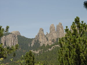 |
Custer Custer County, South Dakota As of the census of 2000, there were 7,275 people, 2,970 households, and 2,067 families residing in the county. The population density was 5 people per square mile . There were 3,624 housing units at an average density of 2 per square mile... |
An excellent, rare example of joint-controlled weathering of granite. | ||
| 7 | Cottonwood Slough- Dry Run | Roberts Roberts County, South Dakota As of the census of 2000, there were 10,016 people, 3,683 households, and 2,618 families residing in the county. The population density was 9 people per square mile . There were 4,734 housing units at an average density of 4 per square mile... |
A completely undisturbed wetland complex including potholes, streams, shallow open water, lakes, and marsh. | |||
| 8 | Fort Randall Eagle Roost | Gregory Gregory County, South Dakota As of the census of 2000, there were 4,792 people, 2,022 households, and 1,290 families residing in the county. The population density was 5 people per square mile . There were 2,405 housing units at an average density of 2 per square mile... |
A prime winter roosting area for bald Bald Eagle The Bald Eagle is a bird of prey found in North America. It is the national bird and symbol of the United States of America. This sea eagle has two known sub-species and forms a species pair with the White-tailed Eagle... and golden eagles Golden Eagle The Golden Eagle is one of the best known birds of prey in the Northern Hemisphere. Like all eagles, it belongs to the family Accipitridae. Once widespread across the Holarctic, it has disappeared from many of the more heavily populated areas... . |
|||
| 9 | Lake Thompson Lake Thompson (South Dakota) Lake Thompson is a lake in Kingsbury County, South Dakota, United States. With an area of , it is one of the largest natural lakes in South Dakota. The maximum depth of the lake is , and the shoreline has a length of . The lake is located in east-central South Dakota, on the Coteau des Prairies and... |
Kingsbury Kingsbury County, South Dakota Kingsbury County is a county located in the U.S. state of South Dakota. As of the 2010 census, the population was 5,148. It's county seat is De Smet. It was named for two brothers, George W. and T. A. Kingsbury, who were prominently involved in the affairs of Dakota Territory and members of... |
Contains a large undisturbed and unmanipulated marsh, an outstanding waterfowl breeding and resting area. | |||
| 10 | Mammoth Site of Hot Springs | Fall River Fall River County, South Dakota As of the census of 2000, there were 7,453 people, 3,127 households, and 1,976 families residing in the county. The population density was 4 people per square mile . There were 3,812 housing units at an average density of 2 per square mile... |
One of the largest concentrations of mammoth remains in the United States. | |||
| 11 | Red Lake | Brule Brule County, South Dakota As of the census of 2000, there were 5,364 people, 1,998 households, and 1,328 families residing in the county. The population density was 6 people per square mile . There were 2,272 housing units at an average density of 3 per square mile... |
One of the largest remaining natural and unmanipulated prairie pothole Prairie pothole The Prairie Pothole Region is an area of the northern Great Plains and midgrass and tallgrass prairies that contains thousands of shallow wetlands known as potholes. These potholes are the result of glacier activity in the Wisconsin glaciation, which ended approximately 10,000 years ago... lakes. |
|||
| 12 | Sica Hollow | Marshall Marshall County, South Dakota As of the census of 2000, there were 4,576 people, 1,844 households, and 1,252 families residing in the county. The population density was 6 people per square mile . There were 2,562 housing units at an average density of 3 per square mile... |
Displays many facets of natural history. | |||
| 13 | Snake Butte | Jackson Jackson County, South Dakota As of the census of 2000, there were 2,930 people, 945 households, and 675 families residing in the county. The population density was 2 people per square mile . There were 1,173 housing units at an average density of 1 per square mile... |
Illustrates one of two types of sand calcite deposits in the world. | |||