

List of National Natural Landmarks in Colorado
Encyclopedia
From List of National Natural Landmarks, these are the National Natural Landmark
s in Colorado
. There are 12 in total, 1 is shared with Wyoming.
National Natural Landmark
The National Natural Landmark program recognizes and encourages the conservation of outstanding examples of the natural history of the United States. It is the only natural areas program of national scope that identifies and recognizes the best examples of biological and geological features in...
s in Colorado
Colorado
Colorado is a U.S. state that encompasses much of the Rocky Mountains as well as the northeastern portion of the Colorado Plateau and the western edge of the Great Plains...
. There are 12 in total, 1 is shared with Wyoming.
| Name | Image | Date | Location | County | Description | |
|---|---|---|---|---|---|---|
| 1 | Lost Creek Scenic Area | Park Park County, Colorado Park County is the 17th most extensive of the 64 counties of the State of Colorado of the United States. The county was named after the large geographic region known as South Park, which was named by early fur traders and trappers in the area. The geographic center of the State of Colorado is... , Jefferson Jefferson County, Colorado Jefferson County , whose slogan is the "Gateway to the Rocky Mountains", is the fourth most populous of the 64 counties of the State of Colorado of the United States. Located along the Front Range of the Rocky Mountains, Jefferson County is adjacent to the west side of the state capital, Denver.... |
Unusual rock formations and underground stream channels. | |||
| 2 | Garden Park Fossil Area | Fremont Fremont County, Colorado Fremont County is the thirteenth most populous of the 64 counties of the state of Colorado of the United States. The county is named for explorer and presidential candidate John C. Frémont. The county population was 46,824 at the 2010 census. The county seat is Cañon City. The Cañon City... |
An internationally known paleontological site. | |||
| 3 | Indian Springs Trace Fossil | Fremont Fremont County, Colorado Fremont County is the thirteenth most populous of the 64 counties of the state of Colorado of the United States. The county is named for explorer and presidential candidate John C. Frémont. The county population was 46,824 at the 2010 census. The county seat is Cañon City. The Cañon City... |
Considered the best trace fossil locality in North America for ancient Ordovician animal life. | |||
| 4 | Morrison Fossil Area | Jefferson Jefferson County, Colorado Jefferson County , whose slogan is the "Gateway to the Rocky Mountains", is the fourth most populous of the 64 counties of the State of Colorado of the United States. Located along the Front Range of the Rocky Mountains, Jefferson County is adjacent to the west side of the state capital, Denver.... |
Site of the first major discovery of giant dinosaur fossils in North America. | |||
| 5 | Raton Mesa | Las Animas Las Animas County, Colorado Las Animas County has the largest area of the 64 counties of the State of Colorado of the United States. Las Animas County takes its name from the Mexican Spanish name of the Purgatoire River, originally called El Río de las Ánimas Perdidas en Purgatorio, which means "River of the Lost Souls in... |
A mesa preserved by a thick lava cap that has resisted destruction from weathering and erosion. | |||
| 6 | Roxborough State Park Roxborough State Park Roxborough State Park is a Colorado State Park known for dramatic red sandstone formations. Located in Douglas County south of Denver, Colorado, the park was established in 1975. In 1980 it was recognized as a National Natural Landmark.-Geography:... |
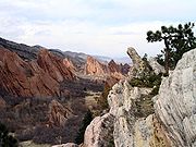 |
Douglas Douglas County, Colorado Douglas County is the eighth most populous of the 64 counties of the state of Colorado, in the United States. The county is located midway between Colorado's two largest cities: Denver and Colorado Springs... |
An excellent example of the tilted and faulted sedimentary strata of the Colorado front range. | ||
| 7 | Russell Lakes | 37°56′41"N 106°07′34"W | Saguache Saguache County, Colorado Saguache County is the seventh most extensive of the 64 counties of the state of Colorado of the United States. The county name comes from a Ute language word meaning “blue earth” or “water at blue earth”. The county population was 5,917 at U.S. Census 2000... |
The most extensive bulrush marsh in Colorado. | ||
| 8 | Slumgullion Earthflow | 37°59′30"N 107°15′25"W | Hinsdale Hinsdale County, Colorado Hinsdale County is the least densely populated of the 64 counties of the State of Colorado of the United States. The county population was 790 at U.S. Census 2000. The county seat and the only municipality in the county is the Town of Lake City. Hinsdale County is named for George A. Hinsdale, a... |
An excellent illustration of the geologic process of mass wasting. | ||
| 9 | Spanish Peaks Spanish Peaks The Spanish Peaks are a pair of volcanic mountains located in southwestern Huerfano County, Colorado. The Ute indians named them Huajatolla , meaning "two breasts". The Spanish name translates as "Breasts of the Earth". The two peaks, West Spanish Peak and East Spanish Peak, are the easternmost... |
Huerfano Huerfano County, Colorado Huerfano County is one of the 64 counties of the State of Colorado of the United States. The county was named for the Huerfano Butte, a local landmark. The county population was 7,862 at U.S. Census 2000... , Las Animas Las Animas County, Colorado Las Animas County has the largest area of the 64 counties of the State of Colorado of the United States. Las Animas County takes its name from the Mexican Spanish name of the Purgatoire River, originally called El Río de las Ánimas Perdidas en Purgatorio, which means "River of the Lost Souls in... |
One of the best known examples of exposed igneous dikes. | |||
| 10 | Summit Lake Summit Lake Park Summit Lake Park is a park located along Mount Evans Scenic Byway about 38 miles west of Denver, Colorado. The park is 160 acres in size and contains alpine tundra. Land to the east of the lake is in a state of permafrost which helps to prevent drainage of the area... |
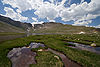 |
39°35′55"N 105°38′39"W | Clear Creek Clear Creek County, Colorado Clear Creek County is one of the 64 counties of the state of Colorado of the United States. The county population was 9,322 at U.S. Census 2000. The county seat is Georgetown... |
A 160 acres (0.65 km²) park which contains alpine tundra Alpine tundra Alpine tundra is a natural region that does not contain trees because it is at high altitude. Alpine tundra is distinguished from arctic tundra, because alpine soils are generally better drained than arctic soils... around a small alpine lake Alpine lake Alpine lakes are classified as lakes or reservoirs at high altitudes, usually starting around 5,000 feet in elevation above sea level or above the tree line.... . Some of the plants that survive in this microclimate are usually found only in the Arctic Circle Arctic Circle The Arctic Circle is one of the five major circles of latitude that mark maps of the Earth. For Epoch 2011, it is the parallel of latitude that runs north of the Equator.... . |
|
| 11 | Garden of the Gods Garden of the Gods Garden of the Gods is a public park located in Colorado Springs, Colorado, USA.-Genesis of the park:Entrance to the park is free according to the wish of Charles Elliott Perkins, whose children donated the land to the city of Colorado Springs in 1909.... |
 |
El Paso El Paso County, Colorado El Paso County is the most populous of the 64 counties of the state of Colorado of the United States, now more populous than Denver County. The United States Census Bureau concluded that the county population was 622,371 in 2010. In recent years, the population had come closer to that of Denver... |
An outstanding illustration of the lithologic character of sedimentary rocks, and of the vertical forces that produced the front range of the Rocky Mountains. | ||
| 12 | Sand Creek | 40°59′49"N 105°46′14"W | Larimer Larimer County, Colorado Larimer County is the seventh most populous and the ninth most extensive of the 64 counties of the State of Colorado of the United States. The county is located at the northern end of the Front Range, at the edge of the Colorado Eastern Plains along the border with Wyoming... |
The most spectacular examples of cross-bedded sandstone and “topple blocks” in North America. NNL area extends across Wyoming border. | ||