
Leadore, Idaho
Encyclopedia
Leadore is an incorporated city of the State of Idaho in Lemhi County
, Idaho
, United States
. The population was 70 in the 1990 census and is currently at 90 from the 2000 census.
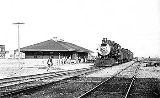
 The town of Leadore dates from 1910, when the Gilmore and Pittsburgh Railroad
was constructed from Armstead, Montana
over Bannock Pass
and into the Lemhi Valley. This occurred because the original location for the train station in the town of Junction had to be altered when the owner of the land refused to sell. The town was home to the railroad's repair shops, and was the point where the railroad's branch line to Gilmore connected with the main line. Though the railroad ceased operating in 1939, Leadore has remained the largest town in the immediate area.
In 2001 a replica of the town's old railway station was constructed in Leadore. The new building serves as the town's community center.
According to the United States Census Bureau
, the city has a total area of 0.3 square mile (0.776996433 km²), all of it land.
of 2000, there were 90 people, 43 households, and 20 families residing in the city. The population density
was 275.1 people per square mile (105.3/km²). There were 66 housing units at an average density of 201.7 per square mile (77.2/km²). The racial makeup of the city was 100.00% White.
There were 43 households out of which 23.3% had children under the age of 18 living with them, 41.9% were married couples
living together, 2.3% had a female householder with no husband present, and 51.2% were non-families. 46.5% of all households were made up of individuals and 20.9% had someone living alone who was 65 years of age or older. The average household size was 2.09 and the average family size was 3.10.
In the city the population was spread out with 24.4% under the age of 18, 1.1% from 18 to 24, 24.4% from 25 to 44, 28.9% from 45 to 64, and 21.1% who were 65 years of age or older. The median age was 46 years. For every 100 females there were 91.5 males. For every 100 females age 18 and over, there were 100.0 males.
The median income for a household in the city was $11,786, and the median income for a family was $13,750. Males had a median income of $32,188 versus $16,250 for females. The per capita income
for the city was $9,452. There were 47.6% of families and 44.8% of the population living below the poverty line, including 50.0% of under eighteens and 28.6% of those over 64.
Lemhi County, Idaho
Lemhi County is a county located in the U.S. state of Idaho. The county was established in 1869, named after Fort Lemhi , a remote Mormon missionary settlement from 1855-58 in Bannock and Shoshone territory. As of the 2000 Census the county had a population of 7,806...
, Idaho
Idaho
Idaho is a state in the Rocky Mountain area of the United States. The state's largest city and capital is Boise. Residents are called "Idahoans". Idaho was admitted to the Union on July 3, 1890, as the 43rd state....
, United States
United States
The United States of America is a federal constitutional republic comprising fifty states and a federal district...
. The population was 70 in the 1990 census and is currently at 90 from the 2000 census.
History
Gilmore and Pittsburgh Railroad
The Gilmore and Pittsburgh Railroad , now defunct, was an American railroad located in southwestern Montana and east-central Idaho. Constructed in 1909 and 1910 between the towns of Armstead, Montana and Salmon, Idaho, the G&P served mining and agricultural areas in Lemhi County, Idaho and...
was constructed from Armstead, Montana
Armstead, Montana
Armstead is a ghost town in Beaverhead County, Montana, United States, about south of the county seat of Dillon. It was named after miner Harry Armstead. Armstead was located in a narrow valley of the Beaverhead River, near the mouth of Horse Prairie Creek. The town was a station stop on the...
over Bannock Pass
Bannock Pass
Bannock Pass is a high mountain pass in the Beaverhead Mountains, part of the Bitterroot Range in the Rocky Mountains The pass lies on the Montana-Idaho border on the continental divide, at an elevation of 7684 feet above sea level....
and into the Lemhi Valley. This occurred because the original location for the train station in the town of Junction had to be altered when the owner of the land refused to sell. The town was home to the railroad's repair shops, and was the point where the railroad's branch line to Gilmore connected with the main line. Though the railroad ceased operating in 1939, Leadore has remained the largest town in the immediate area.
In 2001 a replica of the town's old railway station was constructed in Leadore. The new building serves as the town's community center.
Geography
Leadore is located at 44°40′47"N 113°21′38"W (44.679604, -113.360664).According to the United States Census Bureau
United States Census Bureau
The United States Census Bureau is the government agency that is responsible for the United States Census. It also gathers other national demographic and economic data...
, the city has a total area of 0.3 square mile (0.776996433 km²), all of it land.
Demographics
As of the censusCensus
A census is the procedure of systematically acquiring and recording information about the members of a given population. It is a regularly occurring and official count of a particular population. The term is used mostly in connection with national population and housing censuses; other common...
of 2000, there were 90 people, 43 households, and 20 families residing in the city. The population density
Population density
Population density is a measurement of population per unit area or unit volume. It is frequently applied to living organisms, and particularly to humans...
was 275.1 people per square mile (105.3/km²). There were 66 housing units at an average density of 201.7 per square mile (77.2/km²). The racial makeup of the city was 100.00% White.
There were 43 households out of which 23.3% had children under the age of 18 living with them, 41.9% were married couples
Marriage
Marriage is a social union or legal contract between people that creates kinship. It is an institution in which interpersonal relationships, usually intimate and sexual, are acknowledged in a variety of ways, depending on the culture or subculture in which it is found...
living together, 2.3% had a female householder with no husband present, and 51.2% were non-families. 46.5% of all households were made up of individuals and 20.9% had someone living alone who was 65 years of age or older. The average household size was 2.09 and the average family size was 3.10.
In the city the population was spread out with 24.4% under the age of 18, 1.1% from 18 to 24, 24.4% from 25 to 44, 28.9% from 45 to 64, and 21.1% who were 65 years of age or older. The median age was 46 years. For every 100 females there were 91.5 males. For every 100 females age 18 and over, there were 100.0 males.
The median income for a household in the city was $11,786, and the median income for a family was $13,750. Males had a median income of $32,188 versus $16,250 for females. The per capita income
Per capita income
Per capita income or income per person is a measure of mean income within an economic aggregate, such as a country or city. It is calculated by taking a measure of all sources of income in the aggregate and dividing it by the total population...
for the city was $9,452. There were 47.6% of families and 44.8% of the population living below the poverty line, including 50.0% of under eighteens and 28.6% of those over 64.