
Lautém
Encyclopedia
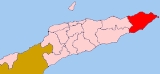
Lautém is one of the districts
of East Timor
, on the eastern end of the island of Timor
. It has a population of 57,453 (census 2004) and an area of 1,702 km2. Its capital is Lospalos
, which lies 248 km east of the national capital, Dili
. The subdistricts are Iliomar
, Lautém
, Lospalos
, Luro
, and Tutuala
.
To the west the district borders the districts of Baucau
and Viqueque
. To the north lies the Banda Sea
, and to the south the Timor Sea
. The district also includes the easternmost point of the island, Kap Cutcha in the subdistrict of Tutuala
, and the small island Jaco
.
The district of Lautém is identical to what was the council of the same name in Portuguese Timor
. At that time, many of the localities had Portuguese names, such as Vila Nova de Malaca (today Lautém
), Nova Nazaré (Com), Nova Sagres (Tutuala
) and Nova Âncora (Laivai).
Lautém has beautiful sand beaches and a wild, mountainous, and raw rugged unspoilt landscape. Many of the endemic birds of East Timor live here. Near the city of Lautém there are cave drawings. Numerous stone sarcophagi and animistic shrines are found throughout the district.
In addition to the official languages of Portuguese
and Tetum, in the district there are 30,000 speakers of the Papuan language Fataluku, mainly in the east of the district, many of whom do not speak a second language.
Districts of East Timor
||East Timor is divided into thirteen administrative districts. The districts are divided into subdistricts, and further subdivided into sucos.The borders between Cova-Lima and Ainaro and between Baucau and Viqueque were changed in 2003.-References:...
of East Timor
East Timor
The Democratic Republic of Timor-Leste, commonly known as East Timor , is a state in Southeast Asia. It comprises the eastern half of the island of Timor, the nearby islands of Atauro and Jaco, and Oecusse, an exclave on the northwestern side of the island, within Indonesian West Timor...
, on the eastern end of the island of Timor
Timor
Timor is an island at the southern end of Maritime Southeast Asia, north of the Timor Sea. It is divided between the independent state of East Timor, and West Timor, belonging to the Indonesian province of East Nusa Tenggara. The island's surface is 30,777 square kilometres...
. It has a population of 57,453 (census 2004) and an area of 1,702 km2. Its capital is Lospalos
Lospalos
Lospalos is a city in East Timor, 248 km to the east of Dili, the national capital. Lospalos has a population of 17,186 and is the capital of the district of Lautém and the subdistrict of Lospalos...
, which lies 248 km east of the national capital, Dili
Dili
Dili, spelled Díli in Portuguese, is the capital, largest city, chief port and commercial centre of East Timor.-Geography and Administration:Dili lies on the northern coast of Timor island, the easternmost of the Lesser Sunda Islands....
. The subdistricts are Iliomar
Iliomar
Iliomar is a town and subdistrict in the Lautém District of East Timor. Its population at the 2004 census was 6,726.-Reference:*...
, Lautém
Lautém (city)
Lautém is a town and subdistrict in the Lautém District of East Timor. Its population at the 2004 census was 13,866.-Reference:*...
, Lospalos
Lospalos
Lospalos is a city in East Timor, 248 km to the east of Dili, the national capital. Lospalos has a population of 17,186 and is the capital of the district of Lautém and the subdistrict of Lospalos...
, Luro
Luro
Luro is a subdistrict and the name of two towns there in the Lautém District of East Timor. Its population at the 2010 census was 5,367, at the 2004 census was 6,205.- Reference :*...
, and Tutuala
Tutuala
Tutuala is a town and subdistrict in the Lautém District of East Timor. Its population at the 2004 census was 3,707....
.
To the west the district borders the districts of Baucau
Baucau (district)
Baucau , is a district of East Timor, on the northern coast in the eastern part of the country. The capital is also called Baucau . The population of the district is 104,571 and it has an area of 1,494 km2. The subdistricts are Baguia, Baucau, Laga, Quelicai, Vemasse, and Venilale...
and Viqueque
Viqueque (district)
Viqueque is the largest of the districts of East Timor. It has a population of 66,434 and an area of 1,781 km2. The capital of the district is also named Viqueque. The subdistricts are Lacluta, Ossu, Uato-Lari , Uato Carabau and Viqueque...
. To the north lies the Banda Sea
Banda Sea
The Banda Sea is a sea in the Maluku Islands of Indonesia, technically part of the Pacific Ocean but separated from it by hundreds of islands, as well as the Halmahera and Ceram Seas...
, and to the south the Timor Sea
Timor Sea
The Timor Sea is a relatively shallow sea bounded to the north by the island of Timor, to the east by the Arafura Sea, to the south by Australia and to the west by the Indian Ocean....
. The district also includes the easternmost point of the island, Kap Cutcha in the subdistrict of Tutuala
Tutuala
Tutuala is a town and subdistrict in the Lautém District of East Timor. Its population at the 2004 census was 3,707....
, and the small island Jaco
Jaco (East Timor)
Jaco is a small island in the Lesser Sunda Islands. It lies across from the easternmost point of the island of Timor, Kap Cutcha. Its geographical coordinates are 8° 27' S and 127° 20' E. Politically it is part of the subdistrict of Tutuala within Lautém district of East Timor...
.
The district of Lautém is identical to what was the council of the same name in Portuguese Timor
Portuguese Timor
Portuguese Timor was the name of East Timor when it was under Portuguese control. During this period, Portugal shared the island of Timor with the Netherlands East Indies, and later with Indonesia....
. At that time, many of the localities had Portuguese names, such as Vila Nova de Malaca (today Lautém
Lautém (city)
Lautém is a town and subdistrict in the Lautém District of East Timor. Its population at the 2004 census was 13,866.-Reference:*...
), Nova Nazaré (Com), Nova Sagres (Tutuala
Tutuala
Tutuala is a town and subdistrict in the Lautém District of East Timor. Its population at the 2004 census was 3,707....
) and Nova Âncora (Laivai).
Lautém has beautiful sand beaches and a wild, mountainous, and raw rugged unspoilt landscape. Many of the endemic birds of East Timor live here. Near the city of Lautém there are cave drawings. Numerous stone sarcophagi and animistic shrines are found throughout the district.
In addition to the official languages of Portuguese
Portuguese language
Portuguese is a Romance language that arose in the medieval Kingdom of Galicia, nowadays Galicia and Northern Portugal. The southern part of the Kingdom of Galicia became independent as the County of Portugal in 1095...
and Tetum, in the district there are 30,000 speakers of the Papuan language Fataluku, mainly in the east of the district, many of whom do not speak a second language.