
Laurel, Oakland, California
Encyclopedia
Laurel is one of the many culturally diverse neighborhoods in Oakland
, California
. It is situated between the foot of the Oakland hills and Mills College
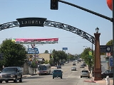
. It lies at an elevation of 226 feet (69 m). At the heart of the neighborhood lies MacArthur Boulevard, a bustling shopping area with annual festivals and many local shops. The Laurel arches on MacArthur Blvd. greet visitors where MacArthur intersects 35th Avenue and High Street.
35th Avenue is the defining east-west reference point through the Laurel District. The south end of the Laurel goes past High Street to the point where Interstate 580 and Highway 13 intersect in a "V". High Street is a major street in the Laurel District. Heading west from Macarthur Blvd. it goes to the south end of the Fruitvale District, but as it heads to the east, past the Laurel Post Office and St. Lawrence O'Toole Catholic Church and School, it goes about a half mile before ending and turning to other smaller residential streets (if followed eventually arrives at Highway 13). 38th Avenue is parallel to and in between 35th Ave and High St, and if traveled to the west a few blocks, just past Interstate 580, it enters the Allendale, Oakland
District, a primarily residential neighborhood, which includes the converted Allendale Theater building, Allendale Park, and Allendale Grammar School. 38th Avenue also eventually reaches Fruitvale furthur in the westerly direction. To the north of 35th Avenue a couple of miles is Coolidge Avenue, separating Laurel from Dimond District.
But 35th Avenue is the main drag on the east-west axis--since it goes straight all the way to East 14th Street to the west, and goes east up to Skyline Boulevard and even beyond into the East Bay Regional Park District, eventually winding all the way to Castro Valley, some twenty miles southeast. 35th Avenue changes names in the process, becoming Redwood Road some eight blocks above MacArthur Boulevard, where there is a curve. At this point the neighborhood is called Redwood Heights. The street retains the name Redwood Road as it drops down the east side of Skyline into the park lands and becomes a rural road.
Laurel, much as other surrounding communities, continues to change as older homeowners move away and younger families move in, some with higher incomes. The neighborhood shows signs of these changes as older homes are renovated and community involvement cleans up "troubled" areas.
In recent years, some have started to insert the article "the" in front of Laurel, as in "I live in the Laurel" or "Shop the Laurel." This practice is frowned upon by long-time residents, who prefer the usage without the article "the". For example, "I live in Laurel" or "I went shopping in Laurel today." Saying "the Laurel District" is acceptable, however.
Surrounding MacArthur Boulevard is a residential area, an elementary school, as well as two highways (Interstate 580
and Highway 13).
operates district public schools. Laurel Elementary School is located in Laurel. Residents are also zoned to Bret Harte Middle School and Skyline High School
.
Two schools of the American Indian Model Schools
, American Indian Public Charter School (AIPCS) and American Indian Public High School (AIPHS), are located in a converted church building in Laurel. By 2006 many Asian-Americans from Laurel began to attend the AIPCS.
Oakland, California
Oakland is a major West Coast port city on San Francisco Bay in the U.S. state of California. It is the eighth-largest city in the state with a 2010 population of 390,724...
, California
California
California is a state located on the West Coast of the United States. It is by far the most populous U.S. state, and the third-largest by land area...
. It is situated between the foot of the Oakland hills and Mills College
Mills College
Mills College is an independent liberal arts women's college founded in 1852 that offers bachelor's degrees to women and graduate degrees and certificates to women and men. Located in Oakland, California, Mills was the first women's college west of the Rockies. The institution was initially founded...
. It lies at an elevation of 226 feet (69 m). At the heart of the neighborhood lies MacArthur Boulevard, a bustling shopping area with annual festivals and many local shops. The Laurel arches on MacArthur Blvd. greet visitors where MacArthur intersects 35th Avenue and High Street.
35th Avenue is the defining east-west reference point through the Laurel District. The south end of the Laurel goes past High Street to the point where Interstate 580 and Highway 13 intersect in a "V". High Street is a major street in the Laurel District. Heading west from Macarthur Blvd. it goes to the south end of the Fruitvale District, but as it heads to the east, past the Laurel Post Office and St. Lawrence O'Toole Catholic Church and School, it goes about a half mile before ending and turning to other smaller residential streets (if followed eventually arrives at Highway 13). 38th Avenue is parallel to and in between 35th Ave and High St, and if traveled to the west a few blocks, just past Interstate 580, it enters the Allendale, Oakland
Allendale, Oakland, California
Allendale is a former settlement in Alameda County, California now annexed to Oakland. It was located northeast of Fruitvale. A post office opened in 1903 and by 1908 was a branch of the Oakland post office. Allendale was named for Charles E...
District, a primarily residential neighborhood, which includes the converted Allendale Theater building, Allendale Park, and Allendale Grammar School. 38th Avenue also eventually reaches Fruitvale furthur in the westerly direction. To the north of 35th Avenue a couple of miles is Coolidge Avenue, separating Laurel from Dimond District.
But 35th Avenue is the main drag on the east-west axis--since it goes straight all the way to East 14th Street to the west, and goes east up to Skyline Boulevard and even beyond into the East Bay Regional Park District, eventually winding all the way to Castro Valley, some twenty miles southeast. 35th Avenue changes names in the process, becoming Redwood Road some eight blocks above MacArthur Boulevard, where there is a curve. At this point the neighborhood is called Redwood Heights. The street retains the name Redwood Road as it drops down the east side of Skyline into the park lands and becomes a rural road.
Laurel, much as other surrounding communities, continues to change as older homeowners move away and younger families move in, some with higher incomes. The neighborhood shows signs of these changes as older homes are renovated and community involvement cleans up "troubled" areas.
In recent years, some have started to insert the article "the" in front of Laurel, as in "I live in the Laurel" or "Shop the Laurel." This practice is frowned upon by long-time residents, who prefer the usage without the article "the". For example, "I live in Laurel" or "I went shopping in Laurel today." Saying "the Laurel District" is acceptable, however.
Surrounding MacArthur Boulevard is a residential area, an elementary school, as well as two highways (Interstate 580
Interstate 580 (California)
Interstate 580 is an 80-mile east–west Interstate Highway in Northern California. The heavily traveled spur route of Interstate 80 runs from San Rafael in the San Francisco Bay Area to Interstate 5 near Tracy in the Central Valley...
and Highway 13).
History
MacArthur Blvd. which runs through the Laurel district was once highway 50 before interstate 580 was built. Two movie houses in the Laurel were in operation from the 1920s until the 1960s. The Laurel Theater is now a church. The Hopkins Cinema is now a Hollywood Video and an auto parts store at 3529 MacArthur Blvd. Earlier (around the 50's)it was a Hagstroms supermarket.Education
The Oakland Unified School DistrictOakland Unified School District
Oakland Unified School District is a public education school district which operates elementary schools , middle schools , and high schools in Oakland, California.-History:...
operates district public schools. Laurel Elementary School is located in Laurel. Residents are also zoned to Bret Harte Middle School and Skyline High School
Skyline High School (Oakland, California)
Skyline High School is a public high school in Oakland, California. It is noted for its strong academics and athletic programs, and consistently ranks as the top performing school in the area in terms of standardized testing, SAT scores, college acceptance rates, and matriculation...
.
Two schools of the American Indian Model Schools
American Indian Model Schools
American Indian Model Schools is a charter school system with its headquarters in Oakland, California.It includes American Indian Public Charter School , a 5th grade-8th grade school, American Indian Public Charter School II , a fifth grade through eighth grade school, and American Indian Public...
, American Indian Public Charter School (AIPCS) and American Indian Public High School (AIPHS), are located in a converted church building in Laurel. By 2006 many Asian-Americans from Laurel began to attend the AIPCS.
See also
- Maxwell Park, OaklandMaxwell Park, Oakland, CaliforniaMaxwell Park is a neighborhood in Oakland, California located in the foothills of Oakland and is known for its close knit community and relatively low crime rate...
External links
- Laurel Neighborhood Map - Oakland Convention and Visitors Bureau
- Laurel District Association - Neighborhood Association for residents and merchants
- Laurel Village Association - Volunteer Neighbors Association for Laurel Residents